PSEB 7th Class Social Science Solutions Chapter 1 Environment

Punjab State Board PSEB 7th Class Social Science Book Solutions Geography Chapter 1 Environment Textbook Exercise Questions and Answers.

PSEB Solutions for Class 7 Social Science Geography Chapter 1 Environment

SST Guide for Class 7 PSEB Environment Textbook Questions and Answers

I. Give answers to the following questions approximately in 1-15 words.

Question 1.
What do you understand by environment?
Answer:
The environment is the surroundings of an organism. It is not the same everywhere. It changes according to the physical factors of some area, i.e. temperature and rainfall which are not the same everywhere.

Question 2.
Which are the main spheres of the environment?
Answer:

  1. Atmosphere,
  2. Lithosphere,
  3. Hydrosphere,
  4. Biosphere.

PSEB 7th Class Social Science Solutions Chapter 1 Environment

Question 3.
How man affects the environment?
Answer:
Man affects the environment in the following ways :

  1. Deforestation’for procuring agricultural land.
  2. Making dams on rivers and changing the direction of- water towards deserts.
  3. Mining to get minerals from the earth.

Question 4.
Write down the names of layers of the earth.
Answer:
The earth has three crusts

  1. Sial
  2. Mantel (Sima)
  3. Nife.

II. Fill in the Blanks :

Question 1.
Environment has been divided in __________ spheres.
Answer:
Four

Question 2.
The SIAL layer of the earth is made up of the material which is rich in and __________
Answer:
Silicon and Aluminium

Question 3.
NiFe is made up of the material which is rich in __________ and __________ elements.
Answer:
Nickel and Ferrous

PSEB 7th Class Social Science Solutions Chapter 1 Environment

Question 4.
The different types of species of animals is known as __________
Answer:
Biodiversity

Question 5.
__________ portion of earth has been covered by hydrosphere.
Answer:
Three fourth.

III. Activity:

Question 1.
Make a list of factors which has effect over the environment.
Answer:

  1. Relief
  2. Temperature
  3. Rainfall
  4. Degradation Processes
  5. Human factors.

PSEB 7th Class Social Science Guide Environment Important Questions and Answers

Multiple Choice Questions :

Question 1.
Which is not a natural ecosystem?
(a) Desert
(b) Forest
(c) Aquarium
(d) None of the above.
Answer:
(c) Aquarium.

PSEB 7th Class Social Science Solutions Chapter 1 Environment

Question 2.
Choose the correct answer out of the three alternatives given :
(a) Hydrosphere
(b) Biosphere
(c) Lithosphere
(d) Atmosphere.
Answer:
(b) Biosphere.

Question 3.
Hard top layer of the earth is called :
(a) Core
(b) Mantle
(c) Crust
(d) Earth.
Answer:
(c) Crust.

Question 4.
Which is a large ecosystem?
(a) Desert
(b) Buildings
(c) Roads
(d) Railways.
Answer:
(a) Desert.

Question 5.
Which is a human made environment?
(a) Mountain
(b) Sea
(c) River
(d) Road.
Answer:
(d) Road.

Fill in the Blanks :

Question 1.
Environment has been divided in __________ sphere.
Answer:
Four

Question 2.
__________ portion of earth has been covered by hydrosphere.
Answer:
Three fourth

PSEB 7th Class Social Science Solutions Chapter 1 Environment

Question 3.
__________ is a human made environment,
Answer:
Road

Question 4.
On __________ june every year world environment day is celebrated.
Answer:
5

Question 5.
__________ environment is the world of nonliving things.
Answer:
Biotic.

True / False :

Question 1.
The combination of Biosphere and physical environment is called ecology.
Answer:
True

Question 2.
The different types of species of animals is known as Biodiversity.
Answer:
True

PSEB 7th Class Social Science Solutions Chapter 1 Environment

Question 3.
Domain of water is called Biosphere.
Answer:
False

Question 4.
The world of living things are called biotic environment.
Answer:
True

Question 5.
Physical environment includes non-living elements.
Answer:
True.

Very Short Answer Type Questions

Question 1.
Name the three realms of the earth.
Answer:
The environment on the earth consists of three major elements-land, water and air. All these elements are very important and lithosphere, hydrosphere and atmosphere are three realms of the earth.

Question 2.
When is the world environment day celebrated?
Answer:
On 5 June.

PSEB 7th Class Social Science Solutions Chapter 1 Environment

Question 3.
What do you mean by Habitat?
Answer:
On the basis, of lithosphere, hydrosphere and atmosphere, a different type of biosphere is created for flora and fauna. Like humans, these also depend upon their environment which is called Habitat.

Question 4.
What do you mean by Ecology?
Answer:
The combination of Bio-sphere and physical environment is called Ecology.

Question 5.
How did the different spheres of the earth come into existence?
Answer:
The earth was a gaseous formation. The gases melt, become cold and solidified. The gaseous elements became atmosphere, watery elements became hydrosphere and solid particles became lithosphere.

Question 6.
What is atmosphere?
Answer:
Around the earth, there is a roundabout of earth which is several hundred kms wide. This is called Atmesphere. This roundabout is about 1600 km in radius but 99% of inhalable air (oxygen) is in the 32 km radius only.

Question 7.
What are the main elements of atmosphere?
Answer:
Temperature, humidity, air pressure, etc.

Question 8.
Describe the distribution of land and wq£er on earth.
Answer:

  • Land-29%,
  • Water-71%.

Question 9.
What is lithosphere? Write two features.
Answer:
The outer solid part of earth’s surface is called lithosphere.

Features:

  • Its thickness is 80-100 km.
  • Its thickness is more on land and less in water.

PSEB 7th Class Social Science Solutions Chapter 1 Environment

Question 10.
What is the utility of lithosphere?
Answer:

  • It provides us forests.
  • It provides grasslands for grazing.
  • It provides land for Agriculture.
  • It provides land for settlement.
  • It is a source of mineral wealth.

Question 11.
Name four types of water bodies included in Hydrosphere.
Answer:
Rivers, lakes, seas, oceans.

Question 12.
State two functions of Atmosphere.
Answer:

  1. It provides life-support gases.
  2. It keeps the earth’s temperature moderate.
  3. It protects us from hot-ultraviolet rays of the sun.

Question 13.
Give four examples of ecosystems.
Answer:

  1. A large rain forest
  2. A grassland
  3. A desert
  4. A mountain.

PSEB 7th Class Social Science Solutions Chapter 1 Environment

Question 14.
Differentiate between Natural and Human Environment.
Answer:

Natural environment Human environment
1. Land, water, air, plants and animals comprise the natural environment. 1. Individual, family, community, education religion,comprise the human environment.
2. It is essential for the existence of plant and human life. 2. It provides knowledge and technology to utilise the natural environment.

Question 15.
Distinguish between Physical and Biological environment.
Answer:

Physical Environment Biological Environment
1. Land, water, air and inorganic elements form the physical environment. 1. Plants, animals (including man) and organisms form biological environments.
2. It is essential for the existence of plants and human life. 2. It provides food and other materials for human beings.
3. It includes non-living elements. 3. It includes all living elements.
4. The physical environment influences human activities. 4. The physical and human environment interact with each other.

Question 16.
What is Biosphere? Write its two components.
Answer:
Plants and animals together form biospljere or the living world. It is narrow zone on the earth where land, water and air comes in contact with each other to support life.

Question 17.
By which name we call the sphere, that is product of interaction of three spheres? Write in brief. ‘ ‘
Answer:
The sphere made up by the combination of three spheres is called biosphere. It is made up of atmosphere, lithosphere and hydrosphere. Biosphere is the most important sphere on the earth because here the effect of natural factors is quite visible.

PSEB 7th Class Social Science Solutions Chapter 1 Environment

Question 18.
What do you mean by changing environment?
Answer:
On the surface, environment is ever changing because all its elements undergo a change. These elements are interdependent. The changes in natural environment brings about changes in Biological environment.

Short Answer Type Questions

Question 1.
Name the uses of Environment.
Answer:

  • It provides the air we breath.
  • It provides water and drink.
  • It provides food we eat.
  • It provides land where we live.

Question 2.
From the earth’s surface till the deep inside, in how many parts has the earth been divided? Write each in brief.
Answer:

  1. Earth’s surface: It is the upper most part of earth. It is called Sial. It has mainly Silicon (Si) and Aluminium (Al).
  2. Mantle: It is the middle part of earth called Sima. Its main components are Silicon (Si) and Magnesium (Mg).
  3. Central part/Core: It is the deep inside of earth called Nife. It has more of Nickle (Ni) and Iron (Ferrous Fe).

PSEB 7th Class Social Science Solutions Chapter 1 Environment 1

Question 3.
What is the importance of oceans?
Answer:
The hydrosphere is the part of the earth’s surface, covered by water. Rivers, lakes, seas and oceans form this sphere. More than 70 per cent of the earth’s surface is covered with water. Continents are like vast islands floating in the oceans. On the other hand, oceans are the major links between landmasses. Water supports all forms of life on the earth and is very crucial for our survival.

Question 4.
‘Man modifies his environments’. Discuss.
Answer:
Human life is closely related to the environment, Man modifies environment according to his needs. He learnt to cultivate crops, domesticate animals and lead a settled life. He used raw materials to make finished goods.

PSEB 7th Class Social Science Solutions Chapter 1 Environment

Question 5.
Why is it necessary to study natural environment?
Answer:
The study of natural environment is necessary because it, provides us conditions for living like land, air, water and food. It affects our economic activities and basic needs of food, shelter and clothing. It is the basic life supporting system on the earth.

Question 6.
‘Most of the environmental problems are man-made.’ Explain.
Answer:
Man is using water, land, soil and other resources at such an alarming rate that there will be serious shortage of these resources in the near future. Careless use may destroy them to such an extent that they may not be available to mankind. Man will have to live in harmony with the environment so that ecological balance is not disturbed.

Question 7.
‘Man has disturbed the environment.’ Discuss.
Answer:
Man has tried to exploit the resources of Biosphere. But he has disturbed the eco-system in this attempt. Human interference with the natural environment has modified or altered the ecosystem in many areas.

  1. Deforestation for cultivation has changed the habitat of the organisms living in the forests.
  2. It has resulted in soil erosion.
  3. Excessive cultivation, over-grazing, and shifting agriculture have increased the rate of soil erosion.
  4. Irrigation projects in dry areas have resulted into salinization of soil and spread of water borne diseases.
  5. Land, air and water have got polluted and have become unsuitable for human consumption.
  6. In recent years, environmental pollution and presence of chemicals in air, water and food has damaged human health.

PSEB 7th Class Social Science Solutions Chapter 1 Environment

Question 8.
‘The earth is a unique planet.’ Give reasons.
Answer:
The earth is a unique planet of the Solar System because its environment favours the evolution and survival of life to make it a life bearing layer or biosphere.

  • It is the only planet supporting plant and human life.
  • On the earth moderate temperatures (Mean temp. 15°C) are found. It is neither too hot like Mercury, nor too cold like Jupiter due to optimum distance of the earth from the sun.
  • The presence of oxygen nad nitrogen in the atmosphere around the earth favours the existence of life on the Earth. The atmosphere protects the earth from high temperatures.
  • The earth is a ‘watery planet’. Water cycle on the earth provides water for growth of all living beings. The earth is the home of man.

Question 9.
Why should we protect our environment?
Answer:

  1. Environment is our basic life support system. It provides the air we breathe, the water we drink, the food we eat and the land where we live.
  2. It provides us natural resources such as wood, fuel, energy and minerals.
  3. Most of the human activities affect the environment in one way or the other.
  4. Many parts of the environment have already been badly damaged by over use or irrational use of resources like forest, pastures and farms.
  5. If we continue to do so, the damage will be irreparable and the consequences will be very serious.

Question 10.
What are the biotic and abiotic components of the natural environment?
Answer:

  • Biotic component is the world of living organisms for example – plants and animals.
  • Abiotic components are non-living elements for example land and minerals etc.

PSEB 7th Class Social Science Solutions Chapter 1 Environment

Question 11.
How many types of environment are there? Give brief account.
Answer:
The environment is of three types-Physical, Cultural and Biological.

  • The physical environment is the prevailing natural conditions comprising the land, water and air.
  • The environment of lifeforms plants, animals including humans and other organisms is called biological environment.
  • Cultural environment includes man-made features like settlements, roads, industries etc.

Long Answer Type Question

Question 1.
Describe the four spheres of environment.
Answer:
Broadly we can divide the environment into four spheres atmosphere, lithosphere, hydrosphere and biosphere.
1. Atmosphere: The atmosphere is the thin layer of air that envelops our earth. It is very dynamic in nature, changes can take place every hour. These changes in the atmosphere produce weather and climate. The atmosphere is not uniform all through its width. There are several layers of the atmosphere. The atmosphere provides a setting in which all forms of life are created and sustained. The force of gravity exerted by the earth holds the atmosphere around it. The atmosphere protects us from scorching heat and harmful ultraviolet radiation.

2. Lithosphere: The lithosphere is the layer of the earth consisting of rock materials, extending both over the continents and ocean basins. The overage thickness of the lithosphere is about 100 km.

  • The lithosphere is composed of oceans and continents. It has two parts—Sial and Sima.
  • The lithosphere is the sphere which provides us land to settle, soils for plants and is a source of mineral wealth.

Four Spheres of The Earth
PSEB 7th Class Social Science Solutions Chapter 1 Environment 2

3. Hydrosphere: The hydrosphere is the part of the earth’s surface, covered by water. Rivers, lakes, seas, and oceans form this sphere. More than 70 percent of the earth’s surface is covered with water. Continents are like vast islands floating in the oceans. On the other hand, oceans are the major link between landmasses. Water supports all forms of life on the earth and is very crucial for our survival. Oceans provide us with food and minerals. Even in the sea-bed, deposits of minerals, oil, and gas are found.

4. Biosphere: The biosphere is a very narrow sphere of the earth that contains life. This sphere includes parts of the atmosphere, hydrosphere, and lithosphere. Most of the living organisms are it plants or animals on the earth are found on or near the surface of land or water surrounded by air. Thus the biosphere is a very narrow zone where life on this planet exists.

PSEB 8th Class Social Science Solutions Chapter 4 Our Agriculture

Punjab State Board PSEB 8th Class Social Science Book Solutions Geography Chapter 4 Our Agriculture Textbook Exercise Questions and Answers.

PSEB Solutions for Class 8 Social Science Geography Chapter 4 Our Agriculture

SST Guide for Class 8 PSEB Our Agriculture Textbook Questions and Answers

I. Answer the following questions in 1-15 words:

Question 1.
What do you understand by Agriculture?
Answer:
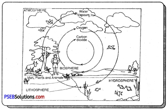
Agriculture includes raising crops, cattle rearing, and other agricultural activities. It also includes dairy farming, poultry, bee-hiving, fishing, floriculture, gur production, flour mills, etc.

Question 2.
Which factors affect Agriculture?
Answer:
The following factors affect agriculture:

  1. Climate
  2. Relief
  3. Type of soil
  4. Irrigation
  5. Method of cultivation
  6. Marketing
  7. Means of transportation and
  8. Banking facilities.

Question 3.
Write a brief note on plantation farming.
Answer:
It includes the cultivation of single crop on large farms.

Question 4.
Write the names of cereal crops.
Answer:
Main cereal crops are Rice, Wheat, Maize, Jowar, Bajra, Pulses and Oilseeds.

PSEB 8th Class Social Science Solutions Chapter 4 Our Agriculture

Question 5.
What is puddling?
Answer:
For rice cultivation, seeds are planted in the fields. The field is levelled and filled with water. This is called puddling the field where rice plants are transplanted.

Question 6.
What products are prepared from Maize?
Answer:
Glucose, starch, alcohol and vegetable oil is prepared from Maize.

Question 7.
How many types of cotton are there on the basis of the length of staple?
Answer:

  1. Long staple cotton (Best Type)
  2. Medium staple cotton
  3. Short staple cotton.

Question 8.
Which are the things that can be made from jute?
Answer:
Bags, ropes, strings, etc. and shoes are prepared from jute.

Question 9.
How does the tea plant look like?
Answer:
Tea plant is a bush. Its leaves provide tea.

Question 10.
Write the names of three types of coffee.
Answer:

  1. Arabica
  2. Robusta
  3. Liberica.

PSEB 8th Class Social Science Solutions Chapter 4 Our Agriculture

Question 11.
What is the percentage of people engaged in agriculture in U.S.A. and Punjab?
Answer:

  • U.S.A.-More than 30% people
  • Punjab-58% people.

II. Answer the following questions in 50-60 words :

Question 1.
After writing the types of Agriculture differentiate between intensive and extensive agriculture.
Answer:
Types of Agriculture :

  1. Sedentary Agriculture
  2. Shifting Agriculture
  3. Dry Farming
  4. Wet Farming
  5. Intensive Farming
  6. Extensive Farming
  7. Mixed Farming
  8. Horticulture
  9. Individual Agriculture
  10. Co-operative Farming
  11. Collective Farming
  12. Plantation Agriculture
  13. Subsistence Agriculture
  14. Commercial Farming.

The distinction between Intensive and Extensive Farming :

  • Intensive farming is done on small farms while extensive farming is done on large farms.
  • Irrigation and fertilizers are used in intensive farming while machines are used in extensive farming.
  • Intensive farming is done in Punjab while extensive farming is done in U.S.A.

Question 2.
Differentiate between subsistence and commercial type of farming.
Answer:
1. Subsistence Farming: Majority of farmers in the country practise subsistence farming. It is characterised by small and scattered land-holdings and use of primitive tools. As the farmers are poor, they do not use fertilisers and high yielding variety of seeds in their fields to the extent they should do. These result into low productivity. Important cash crops like sugarcane, oilseeds, cotton and jute are grown. The subsistence agriculture has given way to commercial agriculture to some extent.

2. Extensive Farming: Extensive farming is bush or tree farming. It is a single crop farming of rubber, tea, coffee, cocoa, spices, coconut and fruit crops. It is capital-intensive and demands good managerial ability, technical know-how, sophisticated machinery, fertilisers, irrigation and transport facilities. Extensive farming is done in U.S.A. and Canada.

PSEB 8th Class Social Science Solutions Chapter 4 Our Agriculture

Question 3.
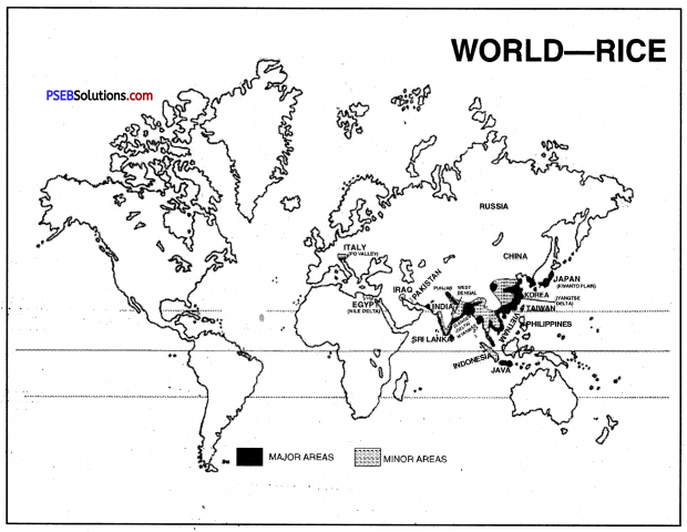
Which are main Rice producing areas?
Answer:
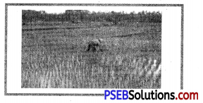
Cultivation of Rice. Rice is grown in deltas, flood-plains, coastal-plains and some terraced fields in the mountainous areas as well. It is one of the crops for which a lot of human labour is required. All operations including the preparation of seedling beds, ploughing, planting, weeding, harvesting and separation of grain are done by human labour.

Rice requires high temperature of over 20°C to germinate, bloom and mature. Rainfall of 100 cm to 150 cm is required. Paddy is cultivated mainly in India, China, Japan, Bangladesh, Indonesia, Thailand and Myanmar.

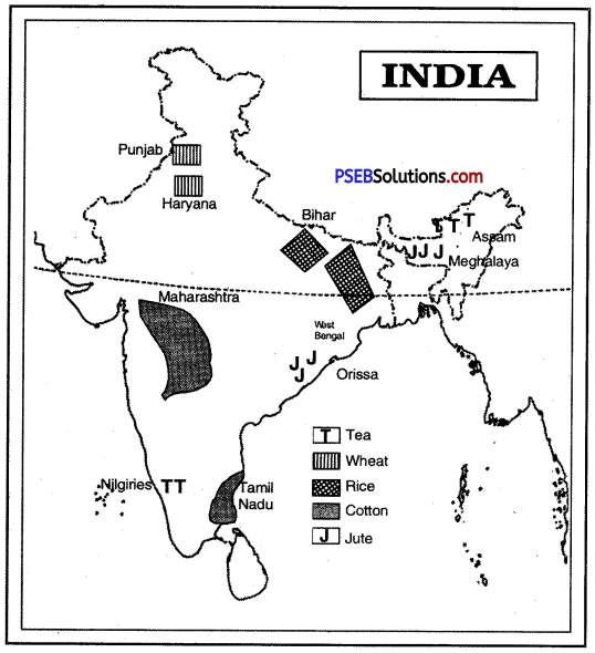
In India rice is cultivated most widely in Uttar Pradesh, West Bengal and Andhra Pradesh. Other producers are Assam, Tamil Nadu, Orissa and Punjab.

In Punjab, rice is grown in districts of Amritsar, Gurdaspur, Ferozepur, Jalandhar, Patiala and Ludhiana.

PSEB 8th Class Social Science Solutions Chapter 4 Our Agriculture 1

Question 4.
Explain the conditions required for cultivation of cotton and jute.
Answer:
Cotton. Cotton requires cloud free sunny days and uniformly high temperature. It grows best in areas where the temperature is between 30°C to. 40°C. Cotton plants require rainfall of 60 to 100 cm. Alluvial and black soils are best suited for cotton plants.

Jute. Jute fibre is obtained from the bark of the jute plant stem.
The jute plant originated in the Indian subcontinent. It grows best in well drained sandy loam and requires warm and humid climate. Jute plant requires temperature of more than 25°C and rainfall of over 150 cm per year.

Question 5.
Write a note on cotton production in Punjab.
Answer:
Punjab and Haryana together produce 25% cotton of India. The major producers are Ferozepur and Sangrur districts. B.T. cotton has been successfully grown in Punjab. Malwa region is also called white gold.

Question 6.
Write about protection of tea and coffee plants.
Answer:
Tea. Tea plants are planted on cleared slope. So that on well drained slopes, water should not stand in the roots of plants. Fertilizers are used for growth of tea plants. Tea plant needs pruning for its proper growth.

Coffee. Coffee saplings are grown in Nursery and then transplanted in the fields. The plants require use of fertilizers, pruning, and irrigation. Sunny weather is required during growth. The tree is pruned to keep it upto a height of 8 feet.

Question 7.
Write a note on the uses of machines in agricultural operations in U.SA.
Answer:
Two types of farms are functioning in the United States viz.,

  1. specialized farms and
  2. mixed farms.

PSEB 8th Class Social Science Solutions Chapter 4 Our Agriculture 2

A specialized farm concentrates on a particular type of crop or livestock, whereas a mixed farm raises a variety of crops. About 95 per cent of farms in the USA are specialized farms. Mostly cereal grains such as corn, wheat, sorghum, rice, barley, oats and rye are grown in specialized farms. However, specialized farms also produce crops such as cotton, groundnut, sugarcane, tobacco, vegetables and fruits. Nearly half the specialized farms in the USA are livestock farms. These livestock farms rear meat animals, raise milk cows, chickens and turkeys. In the mixed farms, farmers produce a variety of crops and rear livestock. The United States is the world’s leader in international agricultural goods market.

III. Answer the following questions in about 125-130 words :

Question 1.
After writing about conditions for the growth of wheat explain the areas of wheat production. (P.B. 2009)
Answer:
Geographical conditions of growth. Wheat needs a cool and wet climate during growing season and a warm dry climate during harvesting season. It requires a rainfall of 50 cm to 75 cm. It is a rabi crop. It grows best in winter due to winter rainfall and regular irrigation. It does not depend on destiny like rice crop. Wheat grows best on loamy soils. Mechanisation and use of chemical fertilizers give higher yields.

Production. Wheat is one of the oldest cereal crops cultivated in the world. Wheat is grown in temperate regions with rainfall ranging between 30 cm to 80 cm.

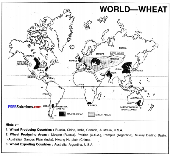
Three countries: the United States of America, Russia and China are the major producers of wheat. The world’s largest producer is China. Other leading producers are India, Ukraine, France, Canada, Pakistan and Argentina. Winter wheat and spring wheat belts of USA and Canada are quite famous.

Wheat cultivation is mainly carried on in fertile soils or loamy soils. Different climatic conditions and sowing seasons across the world have led to harvesting of wheat in every month of the year in one or the other part of the world. It is grown in Punjab, Haryana, Uttar Pradesh, Madhya Pradesh, Maharashtra and Bihar. India is the second largest producer of wheat in the world. The production and yield in Punjab has increased due to Green Revolution, Better seeds, fertilizers and irrigation is used. ,

Question 2.
What are the conditions required for the growth of Tea and Coffee? Explain the main areas of tea and coffee production in India.
Answer:
Geographical Conditions of Growth of Tea. Tea is a plant of both tropical and temperate areas.

  1. Temperature. Tea requires uniformly high temperatures (20° – 30°C) throughout the year. Frost is harmful for tea leaves.
  2. Rainfall. An annual rainfall of 150 cm is essential for the growth of tea.
  3. Soil. Tea requires a deep acidic and fertile soil.
  4. Land. Tea is grown on gently sloping, well drained hill slopes and valley-sides.
  5. Labour. Tea is a labour intensive crop. It requires cheap, skilled labour for picking tea-leaves.

Conditions for Growth of Coffee. One-third of the world population drinks coffee, the second largest beverage after tea. There are two types of coffee plants. Coffee Arabica or Mocha and Coffee Robusta. Robusta is the main variety produced in the world.

The coffee plant requires warm climate and moderate rainfall. Both strong sunshine and snowfall are harmful to the plant. During its growth, coffee plant requires rainfall of 100 cm to 150 cm and temperatures between 15°C and 25°C. Irrigation is required where the annual rainfall is less than 100 cm.

Areas of Cultivation of Tea. More tea is produced in Northern India than Southern India. Tea is grown on an area of 4.21 lakh hectares.

The average yield is 1540 kg per hectare. Assam produces about 50% tea of India.
1. Assam. Assam is the largest producer of tea in India. Tea is grown on the valley sides of Brahmaputra and Duar region.
PSEB 8th Class Social Science Solutions Chapter 4 Our Agriculture 3

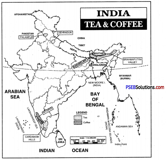
2. West Bengal. Tea is grown in Darjeeling and Jalpaiguri districts in West Bengal. Darjeeling tea has a special flavour. This flavour is due to slow growth under high humidity and low temperature.

3. Southern India. Tea is grown on the slopes of Nilgiris, Cardamom and Anamalai hills, Coimbatore (Tamil Nadu), Malabar coast (Kerala), Coorg region (Karnataka) and Ratnagiri (Maharashtra) are important areas of tea production. Areas of Cultivation of Coffee.

Karnataka is the largest coffee producing state of India.
(а) Karnataka. Coffee is grown in the districts of Chikamanglur, Coorg, Hassan, Shimoga (Nilgiris) in Karnataka state. High rainfall, sunshine, protected slopes, well- drained soils favour the cultivation of coffee.
(b) Arcot, Tinevelley, Madurai, Coimbatore districts of Tamil Nadu grow coffee.
(c) In Kerala, Cardamom hills covering the districts of Palghat and Thiruvananthapuram.

PSEB 8th Class Social Science Solutions Chapter 4 Our Agriculture

Question 3.
Write down the process involved in Jute production. Write in detail the uses and distribution of Jute in the world.
Answer:
Jute: Jute is an industrial fibre. It is the cheapest fibre. It has commercial importance. It is also called ‘golden fibre’. It is used in the making of carpets, ropes, covers and linoleum. It is used for packing many agricultural commodities. Jute is called ‘Brown Paper of Whole-sale trade’. Jute fibre has softness, strength and length.

Conditions of Growth: Jute is a plant of hot-wet tropical areas.

  1. Temperature. It requires uniformly high temperature (27°C) throughout the year.
  2. Rainfall. Jute requires well distributed heavy rainfall (150 cm).
  3. Soil. It is grown on flood plains and deltas. Fertilizers are also used.
  4. Clean Water. Jute needs an ample supply of clean water for washing.

Area and Production: The jute is grown on an area of about 8 lakh hectares. The total production is about 93 lakh bales (each bale = 180 kg). The average yield is 2014 kg per hectare.

India is the largest producer of jute in the world. Due to partition of India 75% of jute producing areas remained in East Pakistan (now Bangladesh). There was shortage of raw jute for jute mills in India. Now India is self-sufficient in jute production. Coarse jute called Mesta is also grown.

Areas of Cultivation

  1. West Bengal. West Bengal is the largest producer of jute in India. Jute is grown in Ganges delta. Murshidabad, Burdwan, Nadiad, Hooghly are the main jute producing districts.
  2. Assam. Jute is grown in Goalpara, Kamrup and Tezpur districts in Brahmaputra valley.
  3. Bihar. Jute is grown in Terai districts of Purnea and Champaran. The major producers of Jute in the world are China, India, Bangladesh, Thailand and Brazil.

Question 4.
What are the similarities and variations in the agriculture of Punjab and the U.S.A.?
Answer:
(A) Agriculture in the U.S.A.-A Glance :

  • Agriculturally, the U.S.A. is a developed country. About 3% of the total population is engaged in agriculture,
  • The main reason behind this is that all the activities of agriculture are carried on by machines and. not by men.
  • Agricultural activities are carried on about 20% part of the land,
  • The main agricultural areas include North-West, North-East, interior plains and coastal plains of the country. Different types of crops are grown in different parts of the country,
  • The farmers of the U.S.A. have large landholdings as compared to that of India. The farm size is very big. The average farm size in U.S.A. is 700 acres. Due to the large size of the fields, extensive type of agriculture is practised.
  • Machines are used at a very large scale. It is almost impossible to work in farms without machines,
  • In a farm, only one type of crop is cultivated. From the sowing of crop to the taking of the crop to markets or stores, every work is done with the help of machines,
  • Insecticides and pesticides are properly utilized. The farmer of U.S.A. practice agriculture like a businessman and not like a mere farmer.

(B) Agriculture in Punjab (India)-A Glance :

  • Punjab in comparison to other states of India, is much advanced in agriculture. The agriculture sector contributes 35% to the total income of the country. About 58% population of the state is engaged in agriculture,
  • The soils here are fertile in nature. To maintain the fertility of the soils, the farmer also uses fertilisers,
  • The farmers of Punjab do not have too much of land. Landholding mostly range between 5 to 25 acres. Some farmers possess even less land. Six percent farmers of the state have more than 25 acres of land.
  • The farmer grows, different types of crops in his fields. The variations in crops mainly depend on climate, size of landholding, type of soil, irrigation facilities and requirements of the farmer.
  • According to the size of the land holding the farmer uses tractor or combine harvester,
  • Almost all the net sown area comes under irrigation. The farmer of Punjab also uses insecticides and pesticides at a large scale to get more production. Though the farmer of Punjab uses the machines, even then the contribution of labourers is too much. This we can estimate from the number of people working in the agricultural sector. In U.S.A. only 3% of population is engaged in agriculture whereas in Punjab 58% people are working in the agriculture sector,
  • The farmer of Punjab (except a few big farmers) does not practice agriculture like a businessmen. He sows a number of crops in his fields. Two-2 crops are taken at the same time,
  • The agriculture of Punjab is an intensive type of agriculture. Therefore, the yield per acre is more than that of the U.S.A.
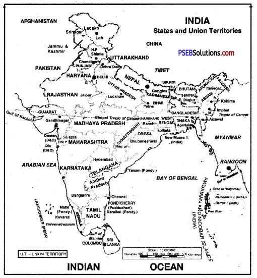
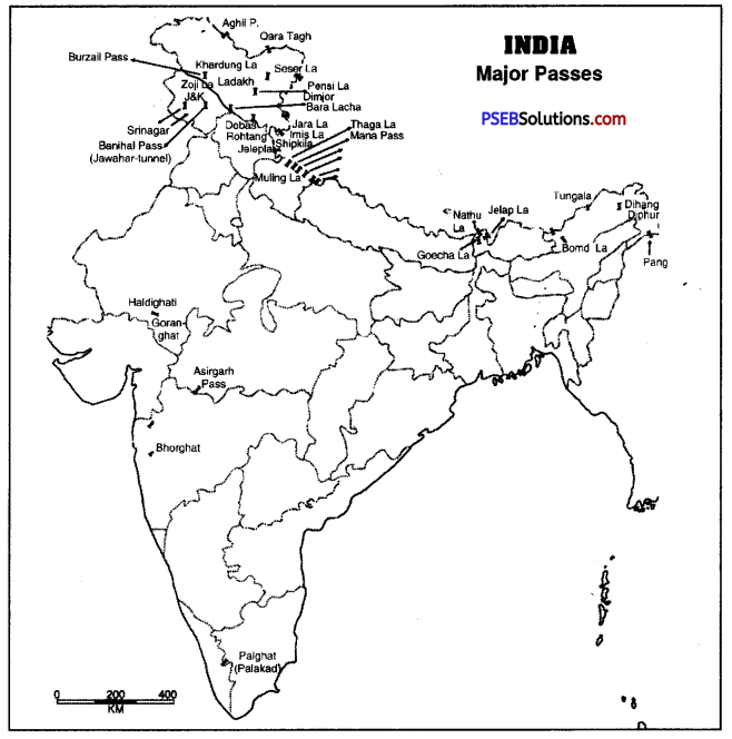
IV. Map Skill

Question 1.
Show two place’s each of following crops on outline map of India. Tea, Wheat, Rice, Cotton, Jute.
Answer:
PSEB 8th Class Social Science Solutions Chapter 4 Our Agriculture 4

PSEB 8th Class Social Science Solutions Chapter 4 Our Agriculture

V. Activity

Question 1.
Name three each of Kharif and Rabi crops mentioning geographical conditions need for each.
Answer:

Crop Temp Rainfall Soils
1. Wheat 10°-20°C 50-100 cm Clay soil
2. Rice 20°-30°C 100-200 cm Alluvial soil
3. Maize 18°-27°C 50-100 cm Levelled plain
4. Cotton 20°-30° 50-100 cm Simple slope
5. Tea 20°-30°C 150-300 cm Sloping
6. Jute 29°-35°C 120-150 cm Alluvial soil

PSEB 8th Class Social Science Guide Our Agriculture Important Questions and Answers

Multiple Choice Questions :

Question 1.
Commercial rearing of silkworm is called
(a) Commercial farming
(b) Pisciculture
(c) Sericulture
(d) Viticulture.
Answer:
(c) Sericulture.

Question 2.
Farming in which the produce is consumed by the farmer’s household is called :
(a) Subsistence
(b) Extensive
(c) Intensive
(d) None of the above.
Answer:
(a) Subsistence.

Question 3.
What does golden filament means?
(a) Cotton
(b) Jute
(c) Silk
(d) Wool.
Answer:
(b) Jute.

PSEB 8th Class Social Science Solutions Chapter 4 Our Agriculture

Question 4.
Which country is the largest producer of rice in the world?
(a) India
(b) Brazil
(c) China
(d) U.S.A.
Answer:
(c) China.

Question 5.
India is largest producer of _________
(a) Tea
(b) Coffee
(c) Rice
(d) Cotton.
Answer:
(a) Tea.

Question 6.
For what purpose the following machine is used?
PSEB 8th Class Social Science Solutions Chapter 4 Our Agriculture 5
(а) For drilling
(b) For showing wheat / rice
(c) For harvesting
(d) For growing vegetables.
Answer:
(c) For harvesting.

Question 7.
In the following picture a plant is shown, name the areas in which plant is found.
PSEB 8th Class Social Science Solutions Chapter 4 Our Agriculture 6
(а) Tropical
(b) Temperate
(c) Tropical & temperate
(d) None of these.
Answer:
(c) Tropical & Temperate.

Question 8.
What is the name of farming of fruit shown in this picture?
PSEB 8th Class Social Science Solutions Chapter 4 Our Agriculture 7
(а) Horticulture
(b) Sericulture
(c) Pisciculture
(d) Viticulture.
Answer:
(d) Viticulture.

Question 9.
Which of the following crops does this picture resemble?
PSEB 8th Class Social Science Solutions Chapter 4 Our Agriculture 8
(a) Paddy (Rice)
(b) Wheat
(c) Maize
(d) Cotton.
Answer:
(a) Paddy (Rice).

PSEB 8th Class Social Science Solutions Chapter 4 Our Agriculture

Question 10.
What type of crops can be grown on the part of land with plenty of black soil?
(a) Sugarcane
(b) Wheat
(c) Cotton
(d) Jute.
Answer:
(c) Cotton.

Fill in the Blanks :

Question 1.
_________ agriculture is done with machines in sparsely populated areas.
Answer:
Extensive

Question 2.
_________ is called cultivation of grapes.
Answer:
Viticulture

Question 3.
Shifting cultivation is also called _________
Answer:
Slash and burn

Question 4.
Coarse grain are also called _________
Answer:
Millets

PSEB 8th Class Social Science Solutions Chapter 4 Our Agriculture

Question 5.
Agricultural activity in India is a _________
Answer:
primary activity.

True/False :

Question 1.
Production of fruit and flower is called viticulture.
Answer:
False

Question 2.
Punjab state is the largest producer of wheat.
Answer:
False

Question 3.
Arabica is a variety of coffee.
Answer:
True

Question 4.
Flax is a fibre crop.
Answer:
True

PSEB 8th Class Social Science Solutions Chapter 4 Our Agriculture

Question 5.
Russia is a leading producer of coffee.
Answer:
False.

Very Short Answer Type Questions

Question 1.
What is meant by agriculture?
Answer:
The word ‘agriculture’ is derived from the Latin words ‘ager’ or ‘agri’ and ’culture’. Ager means soil and culture means cultivation or tilling the soil. Agriculture, thus, means cultivation of soil. But in broader sense, agriculture is growing crops and rearing of livestock. Livestock include animals (cattle, sheep and goat) and birds that are reared for human use.

Question 2.
What are the different forms of the word ‘culture’?
Answer:
The word cuture has many variants like :

  1. Agriculture. Science and art of cultivation on soil, raising crops or livestock.
  2. Sericulture. Commercial rearing of silkworms.
  3. Pisciculture. Breeding of fish for commercial gains.
  4. Viticulture. Cultivation of grapes.
  5. Horticulture. Growing of vegetables, fruits or flowers for commercial use.

Question 3.
What is Sedentary Agriculture?
Answer:
When a farmer practises settled agriculture at a fixed place, it is called sedentary agriculture. Crops can be grown every year at the same field. Organic fertilizers and chemical fertilizers are used to increase the fertility of the soil.

Question 4.
What is mixed farming?
Answer:
In mixed farming, foodgrains, fruit, vegetables are grown along with cattle farming. Fisheries and. bee-hiving is also done. It increases the income of farmers.

PSEB 8th Class Social Science Solutions Chapter 4 Our Agriculture

Question 5.
What is the main characteristic of plantation farming?
Answer:
Crops are grown on large farms. Tea, coffee, rubber are plantation crops which give yield for many years.

Question 6.
Enlist the fibre crops and the beverage crops.
Answer:
Fibre Crops. Cotton, jute, flax.
Beverage Crops. Tea, coffee, cocoa.

Question 7.
Why the people of rich countries prefer wheat to rice?
Answer:
Wheat contains protein, carbohydrate and vitamins. Therefore, wheat is preferred to rice.

Question 8.
State the conditions of growth, temperature, rainfall and land required for maize.
Answer:

  • Temperature: 18°C – 27°C, Frost free season.
  • Rainfall: 50 cm to 100 cm.
  • Land: Level or rolling.

PSEB 8th Class Social Science Solutions Chapter 4 Our Agriculture

Question 9.
What are oilseeds? What is their importance?
Answer:
The seeds which provide oil are called oilseeds. These include til, sunflower, rapeseed, etc. These provide us food and meet our daily needs.

Question 10.
Which sources provide fibre? For which purpose fibre from sheep is used?
Answer:
Fiber is obtained from plants and animals. Wool from sheep is used for woollen clothes.

Question 11.
What is the use of cotton fibre?
Answer:
Cotton fibre is used as a raw material for textile industry. It makes fight and strong clothes.

Question 12.
Explain the term ‘farm system’.
Answer:
Agriculture or farming or cultivation is s system called farm system.

  • Inputs. Include seeds, fertilisers, water, machinery, and labour.
  • Operations. Ploughing, sowing, irrigation, weeding, and harvesting.
  • Outputs. Crops, wool, dairy, products, poultry, etc.

Question 13.
Name the main states producing cotton. Account for large production in these states.
Answer:
Maharashtra, Gujarat and Andhra Pradesh produce more than 60% cotton of India. The large production is due to fertile black soils in these states.

Question 14.
Why is tea grown on hill slopes?
Answer:
Tea needs uniform supply of water throughout the year. Water should not stagnate in the roots of tea bush. Hill slopes are well-drained.

Question 15.
How is coffee powder prepared? Which element of it produces excitement in our bodies?
Answer:
Coffee seeds are dried, roasted and grinded to make powder. It contains Caffeine which produces excitement in our bodies.

Question 16.
How is coffee plant grown?
Answer:
Coffee plant is grown in nurseries. After six months, it is transplanted in fields. It starts giving fruit after 3-4 years.

Question 17.
Agricultural development is uneven in different parts. Give one example.
Answer:
Many parts of Africa are not agriculturally developed. But in U.S.A., agriculture is a commercial and profitable occupation.

PSEB 8th Class Social Science Solutions Chapter 4 Our Agriculture

Question 18.
What is Green Revolution?
Answer:
The increase in agricultural production by introducing scientific methods like; new varieties of seeds, use of fertilizers and good water supply is called green revolution. The increase was in the yields of certain crops like wheat and rice.

Question 19.
Which activities are included in Agriculture?
Answer:
Dairy farming, poultry, honey bee keeping, pisciculture, gur making, flour milks, floriculture all occupations are a part of agriculture.

Question 20.
State two characteristics of Extensive farming.
Answer:

  1. Size of farms is very large.
  2. Yield per acre is less and machines are used for agriculture.

Question 21.
What is the position of Punjab in production of rice?
Answer:
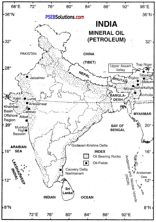
Per hectare yield of rice in Punjab is the highest in India. Punjab produces about 12.2 per cent of total rice of the country. Punjab ranks second in rice production.

Question 22.
If a person has cultivated crops like Tea, Coffee and Cocoa, then identify the types of these crops.
Answer:
Beverage crops.

Short Answer Type Questions

Question 1.
Discuss the main characteristics of shifting cultivation.
Answer:
Shifting Agriculture. In this type of agriculture, first of all, a piece of forest land is cleared by felling trees and burning of trunks and branches. After the land is cleared, crops are grown for two to three years and then the land is abandoned as the fertility of the soil decreases. The farmers then move to new areas and the process is repeated. Dry paddy maize, millets and vegetables are the crops commonly grown in this type of farming. The per hectare yield is low.

Question 2.
Distinguish between dry land farming and wetland farming.
Answer:
Dry land farming. It is practised in areas where the rainfall is low and irrigation facilities are inadequate. Here, emphasis is laid on the conservation of moisture and on crops like jowar, bajra and pulses, which need less water. In dry farming, only one crop is grown in the kharif season.

Wet land farming. It is practised in the areas where rainfall is more than 200 cm per year. It is mostly practised in S.E. Asia. In India, it is practised in West Bengal, Orissa and coastal areas. The main crop is Rice, Sugarcane. Multiple Cropping is done in different seasons.

Question 3.
Distinguish between Individual and Cooperative farming.
Answer:
Individual farming. In this farming, the farmer is the owner of the land. The use of tools, fertilizers and management is in the hands of the farmer. The total income is the personal income of the farmer.

Co-operative farming. In this, the Govt, is the owner of the land. A part of the income goes to the government as tax. The rest of income is divided among the labourers and farmers. This type of agriculture was practised in U.S.S.R.

Question 4.
Write a note on Collective farming.
Answer:
In this type, the farmers join together to form a collective organisation. All the farmers cultivate their own land. The accounts of production is in the hands of the organisation. The decisions are taken for the benefit of farmers. All the profit is distributed among farmers in the ratio of their lands. In India, this type of farming is encouraged by the government.

PSEB 8th Class Social Science Solutions Chapter 4 Our Agriculture

Question 5.
Describe the favourable conditions for growth of Rice.
Answer:

  • Temperature: 20°C to 30°C.
  • Rainfall: 100-200 cm (Irrigation in dry areas)
  • Soils: Alluvial, clay, loamy and delta or black soils.
  • Land: Level land suitable for irrigation.
  • Labour: Cheap and skilled labour.

Question 6.
Describe the cultivation of maize in India and world.
Answer:
Maize: Maize is known as Makka in India, corn in the United States of America, India and Europe. It originated from the American continent. It was introduced in Europe by Columbus and other explorers. It was Native Americans who taught colonizers how to grow maize.

Maize is used as foodgrains and as fodder. It is grown mainly in Russia, Canada and parts of South America. The United States of America is the largest producer. China is the second-largest producer followed by Brazil, Mexico, Argentina and India.

India: Most of Maize is grown in Madhya Pradesh, Andhra Pradesh, Karnataka and Rajasthan. U.P, Himachal Pradesh, J & K, Maharashtra, Punjab and Gujarat are also the producers of Maize. In Punjab, Rupnagar, Amritsar, Hoshiarpur, Jalandhar produce maize.

Question 7.
Write a note on the agricultural development of Punjab.
Answer:
Punjab is one of the leading states of India in agriculture. This is due to :

  • 58% people are engaged in agriculture. 35% of income comes from agriculture.
  • Soils are fertile. Fertilizers are used.
  • Mulitple cropping is done. Better seeds are used. Tractors and Harvesters are used.
  • Irrigation is the basis of agriculture.
  • Pesticides are used to protect crops.
  • Machines are used on large farms.

Question 8.
Why agriculture is called the main stay of the Indian Economy?
Answer:
Indian’s main occupation is agriculture. Two-thirds of India’s population is engaged in agriculture. Agriculture is the main stay of the Indian Economy. Agriculture provides food to the teeming millions in India. It sustains 2/3 of our population. It provides raw material to agro-based industries. Agriculture along with forests and fisheries form 45% of our total national income. Our industrial structure is being built on the broad foundation of Indian agriculture. It is also a great earner of foreign exchange.

Question 9.
What are the main features of Agricultural development in India?
Answer:

  • India is a vast country. More than 70% of its population is dependent upon agriculture for livelihood.
  • The major foodgrains produced in India are rice and wheat.
  • Most of farms are not more than one hectare of land.
  • India is self-sufficient in the production of foodgrains .
  • In India, half of the total cultivable land is irrigated.

Question 10.
What has been the impact of mechanisation on agriculture?
Answer:
The earlier farmers used simple tools. Gradually on-driven ploughs were introduced. But, now in modern times the techniques have been changed. Now in developed countries all farm operations have been mechanised. It has reduced the number of people engaged in agricultural work. Many people can now work in industries and services.

PSEB 8th Class Social Science Solutions Chapter 4 Our Agriculture

Question 11.
What is Agriculture?
Answer:
The word Agriculture is derived from two Latin words ‘agri’ and ‘culture’. ‘Agri’ means’soil and ‘culture’ means cultivation or tilling. Agriculture hence refers to the cultivation of soil for growing crops and rearing of livestocks.

Question 12.
Name the factors influencing agriculture.
Answer:
The factors which influence agriculture are :

  1. Relief
  2. Soil conditions
  3. Temperature
  4. Rainfall.

Question 13.
What is plantation agriculture?
Answer:
It is special type of commercial farming which requires large amount of labour, technical efficiency, very large estates and capital. In this type of agriculture a simple crop of tea, rubber, coffee, sugarcane, cashew, banana or cotton is grown. The produce may be processed on the farm itself or in nearby factories. A well developed transport . network is also required.

Tropical regions of the world are major plantation areas. Rubber in Malayasia, coffee in Brazil, tea in India and Sri Lanka are some examples.

Question 14.
Name the different varieties or crops in India.
Answer:

  1. Cereals
  2. pulses and oilseeds
  3. Fibre crops
  4. Beverage crops
  5. Cash crops

Question 15.
Discuss the different types of fibres.
Answer:
Vegetable fibers are obatained from seeds, barks, leaves and fruit cases.
Animals fibres are produced from insects; such as silkworm and animals such as camels, sheep, goats, yaks, Hamas, rabbits, guanacos, alpacas, vicunas and reindeers.

Mineral fibres such as glass is made from silica sand.
Synthetic fibres are derived from chemical treatment of natural cellulose, which is i made from wood pulp.

Question 16.
What do you know about commercial agriculture?
Answer:
In this type of agriculture the main aim is to produce the crop for sale in the market. It can be intensive or extensive agriculture. The farmers try to keep the cost of production low. The framework is done by machines. This type of agriculture is practised in the prairies of North America, Pampas of South America, Steppes of Russia, Western Europe and in some parts of India.

Question 17.
Write the features of Intensive Subsistence Agriculture.
Answer:
It is a type of subsistence agriculture and its features are :

  • Intensive subsistence agriculture is done on small plot with simple tools.
  • Done by farmer and his family as labour.
  • Produce is used mainly by farmer so food grains are grown.
  • Rice is the main crop. Other crops are wheat, maize, pulses etc are cultivated.
  • Done mainly in thickly populated areas of south, southeast and east Asia.

PSEB 8th Class Social Science Solutions Chapter 4 Our Agriculture

Question 18.
Describe the main characteristics of shifting agriculture.
Answer:

  • In shifting agriculture, a plot of land is cleared by felling trees and burning them.
  • The ashes are then mixed with soil which works as a fertilizer.
  • After the soil loses its fertility, the land is abandoned. Cultivators move to a new plot.
  • It is practised in areas of heavy rainfall and quick generation of vegetation.
  • It is mainly done in Amazon basin, Tropical Africa, Southeast Asia and northeast India.
  • Crops like maize, yam, potatoes, and cassava are grown. This is also known as the ‘slash and burn’ agriculture.

Question 19.
Distinguish between :
(i) Subsistence farming and Commercial farming
Answer:

Subsistence Farming Commercial Farming
1. The practice of farming in which the crops are grown for home consumption by the farmer. 1. The practice of farming in which crops are grown for sale in the market or trade.
2. It is practised on small farms with simple tools and old technology. 2. It is practised on large farms with modern technology.
3. For example The production of wheat in some parts of country. 3. For example The production of sugarcane in U.P.

(ii) Intensive farming and Extensive farming.
Answer:

Intensive Farming Extensive Farming
1. Production is increased by using higher inputs and better agricultural techniques. 1.            Production is increased by bringing more and more land under cultivation.
2. This is practised in areas which are thickly populated. 2. This is practised in areas which are thinly populated.
3. This is practised in areas where there is less land available. 3.            This is done in areas where abundant land is easily available.
4. Livestock farming is little developed due to poor pastures. 4.            Livestock farming Supplements agriculture due to availability of grasslands.
5. Farms are small in size. 5. Farms are very large in size.

Fill in the blanks :

Question 1.
Shifting agriculture is also known as _________
Answer:
Slash and burn

Question 2.
_________, soil and climate are vital factors for agricultural activities.
Answer:
Topography

Question 3.
Advertising is an example of _________ activities.
Answer:
Tertiary

PSEB 8th Class Social Science Solutions Chapter 4 Our Agriculture

Question 4.
Jute is grown intensively in _________ and _________
Answer:
India, Bangladesh

Question 5.
Coarse grains are also called _________
Answer:
Millets.

Long Answer Type Questions

Question 1.
What is the importance of cotton? Explain the conditions of growth and areas of production of cotton and jute in India.
Answer:
Cotton. Cotton has been called ‘the universal fibre’. It is one of the most important fibres of all the fibres. It forms the basis of cotton textile industry. Cotton is the leading fibre crop of India. It is known from the writings of Herodotus that cotton has been in use in India since 3000 B.C.

Geographical Conditions of Growth

  • Temperature. Cotton needs uniformly high summer temperature between 22°C to 32°C. It requires a warm climate with bright sunshine. Frost is harmful to cotton plants.
  • Rainfall. Cotton needs light to moderate rainfall between 50 to 100 cm.
  • Irrigation. In arid treas, irrigation is used. It increases the yield per hectare as in Punjab.
  • Soils. Cotton grows best on rich, well-drained loamy soils or lava soils.

Types of Cotton:

  • The long-staple cotton. This cotton has a length of 25 mm and above.
  • The medium staple cotton. This cotton has a staple length between 18 mm to 25 mm.
  • The short-staple cotton. This cotton has a fibre length of less than 18 mm.

Area of Cultivation
Southern India produces more cotton than Northern India. Gujarat is the leading
producer of cotton in India with a production of 25% of the total production in the country.
1. Black cotton soil region. This is the chief cotton-growing area of India on the ‘lava soil’ of N.W. Deccan Plateau. Gujarat, Maharashtra, and Madhya Pradesh are the major cotton-producing states.

2. Red soil region. Medium staple cotton is grown in the red soil areas including the states of Tamil Nadu, Karnataka, and Andhra Pradesh. The yield is low.

3. Alluvial soil region. Long-staple cotton is grown on the alluvial soils of Northern Plains. The states of Punjab, Haryana, and Rajasthan are the important producers. Punjab has the highest yield per hectare due to its warm climate, fertile soils, and facilities of irrigation.

World Production. The U.S.A. is the leading producer of cotton in the world. China ranks second. India ranks third. Other main producers are Russia, Mexico, Egypt, Sweden, and Pakistan. Egypt is known for long-staple cotton. In the U.S.A., cotton production is decreasing.

PSEB 8th Class Social Science Solutions Chapter 4 Our Agriculture

Question 2.
Describe the different types of Farming.
Answer:
1. Shifting Agriculture. This farming method is practised by primitive people living in dense forests. The land is prepared by felling trees and burning the trees. People move from one area to another when the soil loses its fertility.

2. Subsistence Farming. In this method, farmers use primitive tools to cultivate their lands. Farmers in these regions produce agricultural goods, which are just sufficient to satisfy their own needs.

3. Commercial Farming. When farmers use modern tools and equipment such as tractors, threshers, winnowers, etc., and produce crops mainly to sell them in the market, it is called commercial farming.

4. Extensive Farming. This method is practised in countries where the population is sparse and the availability of land is more. Farmers use machines to a great extent, as the size of land holdings is large.

5. Intensive Farming. In this method of farming, the same piece of land is used throughout the year continuously. The soil is also very fertile. Farmers use more labourers, seeds that can yield more, better manures, and ensure a regular water supply.

6. Irrigation Farming. It is the type of farming, which mainly depends on irrigation through canals, wells, and tanks. Farmers cultivate their lands throughout the year.

Some of the important river valleys of the world where this method is followed are, the Ganga valley and the Indus valley in India, the Nile valley in Egypt, the Xi Jiang valley in China, Missouri, and San Joaquin valley in the United States of America.

7. Rainfed Farming. In the regions where the rainfall is not only seasonal but also scanty, farmers use different measures to cultivate their lands and use the scarce amount of rainwater efficiently. This is known as rainfed farming.

8. Mono-crop Farming. When the farmers specialize in the production of a single crop or if the soil and other natural factors allow farmers to cultivate only one crop that farming is known as one-crop or mono-crop farming.

9. Double and Multi-crop Farming. When two or more crops are cultivated in a plot of land, it is known as double or multi-crop farming. In this method, farmers apply scientific methods—use seeds that can give high yield, and apply manures in an appropriate manner.

PSEB 9th Class SST Solutions Geography Chapter 4 Climate

Punjab State Board PSEB 9th Class Social Science Book Solutions Geography Chapter 4 Climate Textbook Exercise Questions and Answers.

PSEB Solutions for Class 9 Social Science Geography Chapter 4 Climate

SST Guide for Class 9 PSEB Climate Textbook Questions and Answers

Map Work :

Question 1.
Show on the outline map of India :
(i) Direction of Summer Monsoons.
(ii) Direction of Winter Monsoons.
(iii) Two regions receiving more than 200 cm. rainfall.
(iv) Two regions receiving rainfall between 100-200 cm.
(v) Two regions receiving rainfall between 50-100 cm.
Answer:
Do it yourself with the help of India Map.

Question 2.
Class Activity :
(i) Check in the newspapers of March, which regions of Punjab got more than average rainfall. Discuss in your class, the effect of rainfall over underground water, with help of your teacher.
(ii) Note the timings of sunrise and sunset with the help of newspapers in the month of August and discuss ‘Position of Sun and Earth’ with the help of your teacher.
Answer:
Do it yourself with the help of your teacher.

Objective Type Questions :
Answer the following questions in a single word to one sentence length :

Question 1.
What is the reason of winter rainfall in Tamil Nadu?
(a) South-West Monsoon
(b) North-East Monsoon
(c) Local reasons
(d) None of these.
Answer:
(b) North-East Monsoon.

Question 2.
Which city among the following gets maximum average rainfall?
(a) Mumbai
(b) Dharamshala
(c) Mawsynram
(d) Kolkata.
Answer:
(c) Mawsynram.

Question 3.
Which among the following is reason for winter rainfall in Punjab?
(a) Trade winds
(b) Western cyclone
(c) Polar winds.
(d) Mountains
Answer:
(b) Western Cyclone

PSEB 9th Class SST Solutions Geography Chapter 4 Climate

Question 4.
‘Tsunami’ is a word from which language?
(a) French
(b) Japanese
(c) Punjabi
(d) English.
Answer:
(b) Japanese.

Question 5.
Lines joining places with equal rainfall in a map are known as?
(a) Isotherms
(b) Isohyets
(c) Isobars
(d) None of these.
Answer:
(b) Isohyets.

Question 6.
What is Loo?
Answer:
Loo is a local wind. It is very hot and dry wind which blows during the day time in Northern India.

Question 7.
What is climatology called in Punjabi?
Answer:
Mausam Vighaan.

Question 8.
What do you understand by the term ‘Monsoon’?
Answer:
The word ‘Monsoon’ is said to be derived from the Arabic word ‘Mausim’ meaning season. Monsoon winds are those seasonal or periodic winds which change their direction with the season.

Question 9.
What is the relationship of temperature and pressure?
Answer:
They have quite deep relation with each other. Increase in temperature leads to low air pressure and decrease in temperature leads to high air pressure.

PSEB 9th Class SST Solutions Geography Chapter 4 Climate

Question 10.
Name the places with minimum and maximum rainfall in India.
Answer:
Places with highest rainfallMawsynram, Cherrapunji.
Places with lowest rainfall – Western Rajasthan, Kutch region of Gujarat, Ladakh region in Jammu and Kashmir.

Short Answer Questions :
Give short answer for the following questions :

Question 1.
Explain difference between weather and climate.
Answer:

Weather

Climate

1. Weather stands for actual atmospheric conditions for a short period (a day or a week). 1. Climate is the aggregate of atmospheric conditions for a longer period (say 30-50 years).
2. The weather changes from daytoday thus, cannot be generalised. 2. The climate is everlasting and static. It does not change so frequently.
3. Weather depends upon the dominant element at a particular time say Rainfall, temperature etc. 3. Climate is the composite picture of all the elements spread over a longer period.

Question 2.
What do you understand by Ferrel’s law?
Answer:
Coriolis force is an artifact of the earth’s rotation. Once air has been set in motion by the pressure gradient force, it undergoes an apparent deflection from its path, as seen by an observer on the earth. This apparent deflection is called the coriolis force and is a result of the earth’s rotation. As air moves from high to low pressure in the northern hemisphere, it is deflected to the right by the coriolis force. In the southern hemisphere, air moving from high to low pressure is deflected to the left by the coriolis force.

Question 3.
Indian rainfall is neither systemic nor specific. Explain.
Answer:
Indian rainfall is irregular and uncertain. It will be clear by the given ahead points :
1. Summer monsoon is the rain-bringer in India. The weather in S.W. monsoons is highly variable. It does not rain continuously throughout the period of summer monsoons. There are frequent ‘breaks’ or spells of dry weather, some of them lasting several days. This breaks the continuity of rain by S.W. monsoons.

2. The summer monsoons do not have great amount of moisture to give heavy rainfall. The amount of rainfall is increased by tropical depressions, convectional system, and jet stream. These cyclones are irregular and have a fluctuating pattern. The frequency of these cyclones determines the height of rainy season. The absence of these leads to a dry spell.

3. The number of rainy days sometimes increase and sometimes decrease. Some years, it is heavy rainfall, but some years get light rainfall. The start and end of monsoons is early or late. Some areas get high rainfall some areas remain dry.

Question 4.
What is the difference between wind vane and Anemometer?
Answer:
1. Wind Vane. A wind vane is an instrument for showing the direction of the wind. A typical wind vane has a pointer in front and fins in back. When the wind is blowing, the wind vane points into the wind. Reading the wind vane is easy. Whichever direction the fin is pointing will indicate where the wind is coming from.

2. Anemometer. An anemometer is a device used for measuring the speed of wind; and is also a common weather station instrument. It consists of four hemispherical cups mounted on horizontal arms, which are mounted on a vertical shaft. The air flow’past the cups in any horizontal direction turns the shaft at a rate that is roughly proportional to the wind speed. So, counting the turns of the shaft over a set time period produced a value proportional to the average wind spreed for a wide range of speeds.

Question 5.
Write a note on winter rainfall in India.
Answer:
The north plains of India receive winter rainfall ranging between 20 and 50 mm. This rainfall is caused due to the invasion of westerm disturbances (Cyclones). These cyclones originate in West Asia and the Mediterranean Sea. The westerly jet streams steers these cyclones into India during winter. The north west plains get rainfall and the hilly areas get snowfall. In the sameway Tamil Nadu also gets winter rainfall due to retreating monsoon and by the North East monsoon during the winter.

Question 6.
Orographic rainfall is a typically mountainous phenomenon. Explain.
Answer:
Orographic rainfall is produced when moist air is lifted as it moves over a mountain range. As the air rises and cools, orographic clouds form and serve as the source of the precipitation, most of which falls upwind of the mountain ridge. Some also falls a short distance downwind of the ridge and is sometimes called spillover. Because this type of rainfall comes due to mountains, that’s why it comes only in the mountainous region.

PSEB 9th Class SST Solutions Geography Chapter 4 Climate

Question 7.
Write a note on :
(i) Jet stream,
Answer:
Jet stream. A jet stream is a fast flowing wind blowing in narrow zone in the upper atmosphere. The Himalayas divide the jet stream into two parts. A westerly jet stream is placed south of the Himalayas in the winter season. An easterly jet stream is developed at about 25°N in summer. It is believed to be responsible for the sudden outbreak of Monsoons in the Northern India. This is responsible for widespread storms, thunders and rainfall over India in just 8 to 10 days.

(ii) Isotherms,
Answer:
Isotherm. Isotherm are the line drawn on a map or chart joining points with the same temperature. Isotherms are commonly used in meteorology to show the distribution of temperature at the earth’s surface or on a chart indicating constant level or constant pressure.

(iii) Dry and wet bulb thermometer.
Answer:
Dry and wet bulb thermometer. It is an instrument used to measure the relative humidity of the atmosphere. It consists of a thermometer with a bulb that is wet or moist and one that is kept dry. The relative humidity is calculated from the difference in readings of the thermometers when water evaporated from the wet bulb, decreasing its temperature. Humidity in the air is always given in percentage.

Question 8.
Natural calamities cause loss of‘life and property’. In this statement what do you mean by ‘life and property’?
Answer:
There is no denying the fact that whenever any natural disaster occurs, it often leads to the loss of life and property. Here the meaning of life is many people die with the disaster. The meaning of property is many cattle and birds die along with loss of lots of money.

Long Answer Questions :
Answer the following questions in detail:

Question 1.
On what factors does climate of a place depend?
Answer:
The climate of India is mainly based on the following, facts:
1. Latitude. The places which are situated near the equator have high temperature whereas the places away from the equator do not have high temperature.

2. Altitude. The higher you go, the cooler it is. That is why the mountainous regions are cooler than plains.

3. Distance from the sea. The places near the sea have equable climate. Neither the summers are very hot nor the winters are cold, whereas in the parts away from the sea, the summers are hot and winters are cold.

4. Winds. The winds have a great affect on the climate of India. The winds coming from the sea are full of moisture and they cause heavy rain. On the other hand, the winds that come from the land are dry winds and cause no rain.

5. Direction of the mountains. Wherever the mountains are located in the way of the winds, the winds are forced to rise against the mountains and cause rainfall. For example, when the moisture laden monsoon winds strike against Himalayas they cause heavy rain in West Bengal and Assam. On the other hand, the Aravah mountains run parallel to the direction of the monsoon that blow from the Arabian Sea and there is no rain in Rajasthan.

6. Nature of the soil. Sand gets heated and cooled quickly. The land is sandy in Rajasthan. That is why, the temperature is of extreme type there.

7. Slope of the land. If the land slopes towards the sun the rays of the sun will fall vertically and the temperature will be high. On the contrary if the land slopes away from the sun the rays of the sun will be slanting and the temperature will be low.

8. Forests. The regions with dense forests receive heavy rain, because the winds blowing over these forests gain moisture from the leaves of the trees, lose temperature and cause rain.

PSEB 9th Class SST Solutions Geography Chapter 4 Climate

Question 2.
Explain the types of rainfall in detail.
Answer:
There are mainly three types of rainfall and these are :

  1. Convectional Rainfall
  2. Orographic Rainfall
  3. Cyclonic Rainfall.

1. Convectional Rainfall. On equator, sunrays fall directly throughout the year and that’s why this area remains hot throughout the time.
PSEB 9th Class SST Solutions Geography Chapter 4 Climate 1
Due to lot of heat, air pressure reduces to a great extent. When the land warms up, it heats the air above it.
This causes the air to expand and rise. As the air rises, it cools and condenses. If this process continues then rain falls. This type of rainfall is very common in tropical areas. Such rainfall does not last for a very long time because due to less air pressure, rising air is unable to take much of the moisture with it.

2. Orographic Rainfall.
Such rainfall is produced when moist air is lifted as it moves over a mountain range. As the air rises and cools, orographic clouds form and serve as the source of precipitation, most of which falls up wind of the mountain ridge.
PSEB 9th Class SST Solutions Geography Chapter 4 Climate 2
Some also falls a short distance downwind of the ridge and is sometimes called spillover. Such rainfall occurs only in mountains.

3. Cyclonic Rainfall.
Cyclonic or Frontal rain occurs when two air masses meet and form a ‘front’. The warmer, moisture-laden air rises over the colder air as a ‘warm front’. As the air rises it cools, and its relative humidity increases, clouds form as water vapour condenses, and then there is fall of rain. During winters, north and north-west India receives rainfall because cyclones occur in the Mediterranean sea and comes toward India such rainfall is quite useful for the crops of Punjab.
PSEB 9th Class SST Solutions Geography Chapter 4 Climate 3

Question 3.
Name the instruments used for collecting information about various aspects of climate, write in short about all of them?
Answer:
Many instruments are used for collecting information about various aspects of climate and these are given below :
1. Maximum and minimum thermometer. Such a thermometer is used to know about the temperature of a place. If we want to know about the climate of a place, we must know about its temperature. It consists of a U-shaped glass tube with two separate temperature scales set along each arm of the U. One of these is for recording the maximum temperature encountered and the other for the minimum temperature. The arms of the U-shaped tube terminate in sealed glass bulbs. Temperature is measured in centimetre grade or degrees of Fahrenheit.

2. Aniriod Barometer. Aniriod Barometer is a scientific instrument used in meteorology to measure atmospheric pressure. Instead of having a pool of mercury that the atmosphere pushes down or, they have a sealed, air-tight metal box inside. As the air pressure rises or falls, the box either squashes inward a tiny bit or flaxes outward. A spring is cunningly attached to the box and as the box moves in and out in response to the changes in air pressure, the spring expands or contracts and moves the pointer on the dial. The dial is marked with numbers, so you can read the air pressure instantly.

3. Dry and wet bulb thermometer. It is an instrument used to measure the relative humidity of the atmosphere. It consists of a thermometer with a bulb that is wet or moist and one that is kept dry. The relative humidity is calculated from the difference in readings of the thermometers when water evaporated from the wet bulb decreasing its temperature. Humidity in the air is always given in percentage.

4. Rain Gauge. Rain Gauge is used to measure rainfall and the amount of liquid precipitation over a set period of time. Basically it looks like a transparent cylinder with markings. You can read the amount of rainfall in inches or millimetres. It consists of a collector funnel and mechanism to recieve and measure the collected water.

5. Anemometer. An anemometer is a device used for measuring the speed of wind and is also a common weather station instrument. It consists of four hemispherical cups mounted on horizontal arms, which are mounted on a vertical shift. The air flow pass the cups in any horizontal direction turns the shaft at a rate that is roughly proportional to the wind speed. So, counting the turns of the shaft over a set time peirod produces a value proportional to the average wind speed for a wide range of speeds.

6. Wind Wane. A wind wane is an instrument for showing the direction of the wind. A typical wind wane has a pointer in front and fins in back. When the wind is blowing, the wind wane points into the wind. Reading the wind wane is easy. Whichever direction the fin is pointing will indicate where the wind is coming from.

PSEB 9th Class SST Solutions Geography Chapter 4 Climate

Question 4.
What bad effects do natural disasters bring to human lives? Explain.
Answer:
The bad effects of natural calamities is given below :

  • Physical Loss. Natural calamity such as an earthquake can destroy buildings service sector. It can lead to breaking of dams which can further led to more destruction.
  • Death. Earthquake, Tsunami etc. can lead to the death of thousands of people specially people living near the epicentre. Deaths occur more at the places where there is more density of population.
  • Public Health. Thousands of people can be wounded along with broken bones and even the spread of epidemics.
  • Problem in Water Supply. Breaking down of dams and even water supply system can lead to obstacles in water supply.
  • Electricity and Communication. All the communication systems and electric system can get destroyed which can lead to the stand still of the national economy.

PSEB 9th Class Social Science Guide Climate Important Questions and Answers

Multiple Choice Questions :

Question 1.
Which of these seasons do not occur in south India.
(a) Summer
(b) Rainy
(c) Winter
(d) Autumn.
Answer:
(c) Winter.

Question 2.
Cyclonic Rainfall in West Bengal is known as
(a) Kal Baisakhi
(b) Monsoon
(c) Loo
(d) Tsunami.
Answer:
(a) Kal Baisakhi.

Question 3.
Hot and dry wind blowing in north India during summer is known as
(a) Tsunami
(b) Monsoon
(c) Kal Baisakhi
(d) Loo.
Answer:
(d) Loo.

Question 4.
____________ is the most affected area by the Bay of Bengal branch of south-west monsoon.
(a) Chennai
(b) Amritsar
(c) Mawsynram
(d) Shimla.
Answer:
(c) Mawsynram.

Question 5.
____________is majorly affected by the retreating monsoon.
(a) Chennai
(b) Shimla
(c) Delhi
(d) Amritsar.
Answer:
(a) Chennai.

Question 6.
____________ and are two months mostly affected by rain in the whole India.
(a) June, July
(b) July, August
(c) August, September
(d) June, August.
Answer:
(b) July, August.

PSEB 9th Class SST Solutions Geography Chapter 4 Climate

Question 7.
When did Tsunami come?
(a) 26 Dec. 2004
(b) 26 Dec. 2006
(c) 25 Nov. 2003
(d) 25 Nov. 2002.
Answer:
(a) 26 Dec. 2004.

Question 8.
____________ is used to know about the air pressure.
(a) Rain Gauge
(b) Aniriod Barometer
(c) Wind wane
(d) Anemometer.
Answer:
(b) Aniriod Barometer

Fill in the blanks :

Question 1.
Most of the rainfall (75-90%) in India occur during the months from June to
Answer:
September

Question 2.
Rainfall coming with western disturbances is useful for crops.
Answer:
Rabi

Question 3.
Mango shower is useful for the crop of
Answer:
Flowers

Question 4.
____________ coast gets winter rainfall in India.
Answer:
Coromandal

Question 5.
____________ climate is there in the coastal regions of India.
Answer:
Moist

PSEB 9th Class SST Solutions Geography Chapter 4 Climate

Question 6.
____________ is used to measure moisure moisture in air.
Answer:
Dry and wet bulb thermometer

Question 7.
Around people died in many Indian state due to Tsunami.
Answer:
10,500.

True/False :

Question 1.
India has hot climate.
Answer:
True.

Question 2.
Indian climate is very much influenced by monsoon winds.
Answer:
True.

Question 3.
The distribution of rainfall is same in all the parts of India.
Answer:
False

Question 4.
There is a feature of Monsoon type of rainfall that there is no dry spell in it.
Answer:
False

Question 5.
Summer season in India is the lengthiest in all the seasons.
Answer:
True.

Question 6.
Temperature is measured with Aniroid Barometer.
Answer:
False

Question 7.
Wind speed is measured with Anemometer.
Answer:
True.

Very Short Answer Type Questions

Question 1.
Which land form of India acts as a powerful climatic divide?
Answer:
Himalaya mountain acts as a powerful climatic divide.

Question 2.
Which part of India gets rainfall due to western disturbances and for which crop is it useful?
Answer:
North India gets rainfall due to western disturbances and it is useful for rabi crop.

Question 3.
When India gets maximum rainfall?
Answer:
India gets maximum rainfall (75-90%) during the months from June to September.

Question 4.
Give one feature of retreating monsoon.
Answer:
At this time, low pressure area of monsoon becomes weak and it is replaced by high pressure area.

Question 5.
Name two branches of South-West monsoon in India.
Answer:
Arabian sea branch and Bay of Bengal branch.

PSEB 9th Class SST Solutions Geography Chapter 4 Climate

Question 6.
Which part of India has maximum temperature in the beginning of summer season (March)?
Answer:
In the beginning of summer season, southern plateau has maximum temperature.

Question 7.
Which place gets maximum rainfall in the world?
Answer:
Mawsynram gets maximum rainfall in the world.

Question 8.
Which coast of India gets rainfall during winters?
Answer:
Coromandal Coast.

Question 9.
What type of climate does Indian coastal regions have?
Answer:
Equitable climate.

Question 10.
From which word, the word Monsoon originated?
Answer:
The word monsoon originated from the Arabian word Mausim.

Question 11.
What is the average rainfall in India?
Answer:
118 cm of rainfall.

Question 12.
In which part of India, temperature remains high throughout the year?
Answer:
Southern part of India.

Question 13.
What do we call to cyclonic rainfall in West Bengal?
Answer:
Kal Baisakhi.

PSEB 9th Class SST Solutions Geography Chapter 4 Climate

Question 14.
What do we call to the local hot wind blowing in north India during summer season?
Answer:
It is called Loo.

Question 15.
Which hills get maximum rainfall in India?
Answer:
The Hills of Meghalaya.

Question 16.
What is the annual rainfall Mawsynram gets?
Answer:
1141 cm.

Question 17.
Name any two factors affecting climate of India?
Answer:

  1. Distance from equator
  2. Nearness to Indian ocean
  3. Air pressure system
  4. Land form.

Question 18.
Name two places each with minimum and maximum temperature during winter season.
Answer:

  • Minimum Temperature-Amritsar and Leh
  • Maximum Temperature-Mumbai and Chennai.

Question 19.
Name the coldest and hottest places in India during the summer season.
Answer:

  • Coldest place-Leh, Shillong
  • Hottest place-North-West plains of India.

Question 20.
What are Kal Baisakhi?
Answer:
The destructive cyclones are called Kal Baisakhi in West Bengal.

PSEB 9th Class SST Solutions Geography Chapter 4 Climate

Question 21.
What is meant by Mango Shower?
Answer:
North-East Monsoon gives rain in coastal areas of Kerala and Karnataka at the end of summer season. It is called Mango Shower.

Question 22.
At which places do the Monsoon winds coming from Arabian sea and Bay of Bengal meet?
Answer:
The Monsoon winds from Arabian sea and Bay of Bengal meet in Punjab and Himachal Pradesh.

Question 23.
Name the types of rainfall.
Answer:
Three types – Convectional rainfall, Orographic rainfal and Cyclonic rainfall.

Question 24.
Why do Orographic rainfall fall continuously and for a long time?
Answer:
Monsoon winds continuously move from sea to land because of which orographic rainfall fall continuously and for a long time.

Question 25.
Which rainfall is good for the crops of Punjab?
Answer:
Cyclonic rainfall of winters is good for the crops of Punjab.

Question 26.
What is monsoon burst?
Answer:
When monsoon, all of a sudden, gives rainfall, it is called monsoon burst.

Question 27.
What do you mean by Loo?
Answer:
Loos are hot dusty winds caused by low pressure in hot season. These are very hot and are called Loo in local language.

Question 28.
Which instruments are used to check climate or weather?
Answer:
Maximum and minimum thermometer, Aniriod Barometer, Dry and wet bulb thermometer, Rain Gauge, Anemometer, Wind Wane etc.

PSEB 9th Class SST Solutions Geography Chapter 4 Climate

Question 29.
Give major types of natural calamity.
Answer:
Natural calamity comes in different forms such as earthquake, tsunami, cyclone, flood, drought, volcanic eruption etc.

Question 30.
When and in which year did Tsunami come in Indian states?
Answer:
Tsunami came in December, 2004 in Andeman Nicobar, Coast of Tamil Nadu, Andhra Pradesh, Kerala etc.

Question 31.
What type of destruction was caused by Tsunami?
Answer:
It caused death of thousands of persons and damage of property as well.

Short Answer Type Questions

Question 1.
Name the traditional names according to Indian system of Seasons.
Answer:

S.No. Season

Indian Traditional Names

1. Winter Season Mixture of Basant and winter
2. Summer Season Hot Season
3. Rainy Seaspn Rainy Season
4. Season of retreating monsoons Sharad Season

Question 2.
Mumbai is colder than Nagpur. Why?
Answer:
Nagpur is situated away from sea. Whereas Mumbai is situated on the sea shore. There is equable type of climate in Mumbai due to effect of sea. Therefore there is less cold.

In the opposite of it, Nagpur is situated far away from sea and free from sea effect. Therefore, extreme type of climate is found here.

Therefore, Nagpur is colder than Mumbai in winter.

Question 3.
Most of the average Annual rainfall in India comes in just four months of the year.
Answer:
In India, rainfalls mostly from mid-June to mid-September. The Monsoon winds coming from sea blow over India in these four months. There vapour laden winds give heavy rainfall in India.

PSEB 9th Class SST Solutions Geography Chapter 4 Climate

Question 4.
Mawsynram receives maximum rainfall in the world.
Answer:
Mawsynram is situated on southern part with of Garo and Khasi hills. It is situated at the head of a Funnel shaped hill. One branch of Monsoon winds of Bay of Bengal give rainfall here. Due to the strange position of these waves Mawsynram had become the place in world with highest rainfall.

Question 5.
Kolkata receives 145 cm of rainfall where as Jaisalmer receives only 12 cm of rainfall by the South West monsoon.
Answer:
The S. W. Monsoons, from Bay of Bengal, first of all strike in Kolkata in West Bengal. These moisture laden winds give a heavy rainfall of 145 cms here.

Jaisalmer lies to the west of Aravallis in Rajasthan. Aravallis lie parallel to S.W. Monsoons of Arabian sea. So these mountains fail to check S. W. monsoons. These winds move northward giving only 12 cms of rainfall.

Question 6.
Chennai receives most rainfall during winter season.
Answer:
Chennai is situated on Eastern coastal plain of India. It comes under the effect of North-East Monsoon winds. These winds move from land to sea. But while crossing the Bay of Bengal, these pick up moisture. After striking Eastern ghats, these give heavy rainfall in winter. In summer, it gets less rain as it is a rain shadow area.

Question 7.
What is the contribution of western Jet stream in bringing cyclonic rainfall?
Answer:
The west and central Asia remain under the influence of westerlies. A current of westerlies, known as jet stream blows north of the Himalayas, while its southern branch flows south of the Himalayas along 25° N latitude. This branch of jet stream helps in bringing the western disturbances to the Indian sub-continent during winter. These western disturbances originate in west Asia and near the Mediterranean Sea. The westerly jet travels eastwards and steers at least four or five such depressions in India during winter. These cause the needed rainfall on plains and snowfalls on Himalayas.

PSEB 9th Class SST Solutions Geography Chapter 4 Climate

Question 8.
In spite of being close to the Arabian Sea, why does Rajasthan remain dry?
Answer:
The western part of Rajasthan is desert. It gets an annual rainfall less than 20 cms. This is due to the following reasons :

  • Rajasthan is under the influence of S.W. Summer monsoons. The Aravallis system lies parallel to the direction of S.W. monsoons coming from Arabian Sea. So this mountain system is unable to check these winds. So western Rajasthan is practically dry. The southern part get some rainfall.
  • This area lies at a great distance from the Bay of Bengal. The Bay of Bengal monsoons become dry and lose their moisture when they reach Rajasthan.
  • This area is away from the Himalayan region. So it does not come under the influence of monsoons giving rain in Sub-Himalayan region.

Question 9.
How does Himalayas act as a ‘climatic divide’ for India?
Answer:
The Himalayas act as a mountain wall to protect the sub-continent from the northern winds. These cold chilly polar winds cannot enter India, as these cannot cross the lofty Himalayas. So these mountains enable Northern India to have a tropical climate. Thus the Himalayas act as an effective climatic divide.

Question 10.
Distinguish between Mango showers and Kal Baisakhi.
Answer:
Mango Showers. Local rainfall in coastal areas of Kerala and Karnataka at the close of summer premonsoons is called Mango showers. It helps in early ripening of mangoes.

Kal Baisakhi. In summer, West Bengal and Assam get sharp showers by evening thunder-storms. These are called Kal Baisakhi. It means calamity of the month of Baisakh.

Question 11.
Name three characteristics of retreating monsoons.
Answer:
The months of October and November are known for retreating monsoons,

  • The monsoon low pressure trough becomes weaker and is replaced by high pressure.
  • The effect of monsoons over Indian landmass begins to shrink.
  • The direction of surface winds starts reversing.

Question 12.
Why does the Pre-Monsoonal rainfall occur?
Answer:
In summer, equatorial low pressure shifts towards Tropic of Cancer. To fill this space, the S.E. trades cross the Equator and get a direction of S.W. winds due to rotation of the earth. On 1st June, when these winds reach west coast, moderate rainfall occurs on windward slope of west ghats. This is called pre-monsoonal rainfall.

PSEB 9th Class SST Solutions Geography Chapter 4 Climate

Question 13.
Which elements affect the climate of India?
Answer:
The climate of India is mainly based on the following facts :

  1. Distance from the equator. The places which are situated near the equator have high temperature whereas the places away from the equator do not have high temperature.
  2. Height above sea level. The higher you go, the cooler it is. That is why the mountainous regions are cooler than plains.
  3. Distance from the sea. The places near the sea have an equable climate. Neither the summers are very hot nor the winters are cold, whereas in the parts away from the sea the summers are hot and winters are cold.
  4. Winds. The winds have a great affect on the climate of India. The winds coming from the sea are full of moisture and they cause heavy rain. On the other hand, the winds that come from the land are dry winds and cause no rain.

Question 14.
Give main features of Monsoon rainfall.
Answer:

  1. Uncertain rainfall. Summer rainfall is quite uncertain. Sometimes monsoons start early resulting in floods. Often the onset of monsoons is delayed resulting in drought. The early or late retreat of monsoons also results in serious droughts.
  2. Unequal distribution. The rainfall is unevenly distributed over the country. About 10% of the country gets more than 200 cms of rain while 25% of the country gets less than 75 cms of rain.
  3. Heavy rainfall. Indian rainfall is heavy and downpouring type. It is often said, “It pours, it never rains in India”.
  4. Relief rainfall. The amount of rainfall is determined by the presence of mountains. High mountains force monsoons to rise and or rain.

Question 15.
Write a note on winter season.
Answer:
The cold season lasts from December to February. The sun is over head at Tropic of Capricorn. The Indian sub-continent has winter season. January is the coldest month. The southern parts have warm conditions. (20°C) while low temperatures (10°C) are found in N.W. India.

High pressure is developed over N.W. part while a low pressure exists over Indian Ocean with the result winds blow from land to sea. The out-blowing winds are Westerly in Northern plain and North Easterly over the rest of the country.

The N.E. Monsoons are off-shore winds and are dry. But these winds pick up some moisture crossing Bay of Bengal and give rain to S.E. coast of India. Some cyclones from the Mediterranean Sea also bring a small amount of rain (10 to 20 cms.) to Northern plains. Night Frost is common in the N.W. parts.

PSEB 9th Class SST Solutions Geography Chapter 4 Climate

Question 16.
Write a note on the Summer Season.
Answer:
The hot season lasts from March to May. As the sun’s rays fall vertical over ‘Tropic of Cancer, the temperature begins to rise’. The average temperature is above 30°C; the maximum temperature rises to 50°C in Barmer (Rajasthan). The daily range of temperature rises in inland areas. Intense heat results in the development of low pressure over N.W. India and Pakistan. A high pressure exists over Indian Ocean. S.W. Monsoons “begin to blow from sea to land. ‘Norwesters’ and ‘Loo’ blow over Northern plains. Some areas receive convectional rainfall. The west coast also starts receiving rainfall. Most of the country is dry in the pre-Monsoon period.

Question 17.
Why and how is Maximum and Minimum Thermometer used?
Answer:
Such a thermometer is used to know about the temperature of a place. If we want to know about the climate of a place, we must know about its temperature. It consists of a U shaped glass tube with two separate temperature scales set along each arm of U. One of these is for recording the maximum temperature encountered and the other join the maximum temperature. The arms of the U-shaped tube terminate in sealed glass bulb. Temperature is measured in centimetre grade or degrees of Fahrenheit.

Question 18.
Write a note on Aniriod Barometer.
Answer:
Aniriod Barometer is a scientific instrument used in meteorology to measure atmospheric pressure. Instead of having a pool of mercury that the atmosphere is down on, they have a sealed, air-tight metal box inside the air pressure rises or falls, the box either squashes inward a tiny bit or flexes outward. A spring is cunningly attached to the box and as the box moves in and out it response to the changes in air pressure, the spring expands or contracts and moves the pointer on the dial. The dial is marked with numbers so you can read the air pressure instantly.

Question 19.
Write a note on Rain Gauge.
Answer:
Rain Gauge is used to meausre rainfall and the amount of liquid precipitation over a set period time. Basically, it looks like a transparent cylinder with markings. You can read the amount of rainfall in inches or millimetres. It consists of a collector funnel and mechanism to recive and measure the collected water.

Question 20.
Give a brief description of Tsunami.
Answer:
Tsunami is a Japanese word which means a high sea wave. If Tsunami comes at a place, very high sea waves occur at that place. Their height goes upto 10 metre to 50 metre at sea shore. Their speed is quite high. In an open sea, they move at the speed of 400 km-1000 km per hour. Actually if earthquake comes under sea bed, it causes Tsunami. On 26 December, 2004, Tsunami came in South-East Asia which caused a great destruction. Around 10,500 people died in India and it caused a lost of? 10,000 crore to many Indian states.

Long Answer Type Questions

Question 1.
What are the regional variations in the climate of India?
Answer:
1. Range of Temperature. There is a great variation in range of temperatures in different parts of India. Kerala and Andaman-Nicobar islands have a daily range of temperature i. e. 8° C. On the other hand in Thar Desert, if the day temperature is around 50° C, at night it may drop down very close to freezing point (0°C). The daily range of temperature is 50°C.

2. Direction of Rain Bearing Winds. Most of India gets rain in summer from S. W. Monsoons but, in winter Tamilnadu gets rain from N. E. Monsoons.

3. Form of Precipitation. Most of the country gets rain showers, while snowfall occurs in the Himalayas.

4. Amount of Rainfall. The annual rainfall is less than 10 cms in N. W. Himalayas and the Thar Desert, it exceeds 400 cms. in Meghalaya. Mawsynram gets 1,141 cms Rainfall.

5. Rainfall Regime i.e. Seasonal Distribution of Rainfall. There is a great variation in rainfall regimes in the country. Most of the country gets rain from advancing monsoons in summer. Tamilnadu gets rainfall in winter from N.E. monsoons. Some parts receive rainfall from retreating monsoons.

Question 2.
Give an account of the main reasons for the climatic variations in the country.
Answer:
There are great variations in the climate of India. It is not the same throughout the year due to:

  • Northern hilly region remains cold due to high altitude. Coastal areas have an equable climates. Interior areas have high temperatures.
  • Windward slopes get high rainfall but rain shadow areas are dry.
  • In summer, wind blow from sea to land. These moist winds give heavy rainfall. But as these move ahead, the rainfall goes on decreasing.
  • In winter the winds blow from land to sea. These winds are dry. Only S.E. coast of India gets rainfall. Other parts remain dry.

PSEB 9th Class SST Solutions Geography Chapter 4 Climate 4
Monsoons Advancing Season

PSEB 9th Class SST Solutions Geography Chapter 4 Climate

Question 3.
Describe India’s rainy season in India.
Answer:
Rainy season is also called the South West Monsoon season. Its time period is from the June to mid September. The main characteristics of this season are :

  1. A low pressure trough is developed in north-west India.
  2. Winds enter into the country from sea and give heavy rainfall.
  3. The winds filled with humidity move at the rate of 30 km per hour and spread into whole country within one month.
  4. Indian peninsula divides Monsoon into two parts—Monsoon winds of Arabian Sea and Monsoon winds of Bay of Bengal.
  5. Most of rainfall in Western ghat and North East area of India is done by monsoon winds of Bay of Bengal. There is more than 250 cm of rainfall on the winward slopes of western ghats. On the opposite, there is more than 50 cm of rainfall on leeward slopes. Therefore, due to the reason most of rainfall in Northeast states of India is highest and longer on hills of Eastern Himalayas. On the opposite the amount of rainfall goes on decreasing from going East to West.

Question 4.
Give the main characteristics and effects of monsoon rainfall in India.
Answer:
Characteristics of rainfall in India : The average annual rainfall in India is about 110 cms. It is estimated that more than 85% of this rainfall is received in summer. The main characteristics of summer rainfall are as follows :

  1. Monsoonal rainfall. Most of the rain is received from S.W. summer monsoons during the period mid-June to mid-September. It is seasonal rainfall.
  2. Uncertain rainfall. Summer rainfall is quite uncertain. Some times monsoons start early resulting in floods. Often the on set of monsoons is delayed resulting in drought. The early or late retreat of monsoons also results in serious droughts.
  3. Unequal distribution. The rainfall is unevenly distributed over the country. About 10% of the country gets more than 200 cms of rain while 25% of the country gets less than 75 cms of rain.
  4. Heavy rainfall. Indian rainfall is heavy and downpouring type. It is often said, “It pours, it never rains in India”.
  5. Relief rainfall. The amount of rainfall is determined by the presence of mountains. High mountains force monsoons to rise and or give rain.
  6. No continuity of rainfall. Summer rain is characterised by breaks or dry spells.
  7. Variable rainfall. Most of the areas have variable rainfall, as much as 30 cms. plus or minus. Due to variability in areas of low rain, famines result.

Question 5.
Tnspite of great monsoon unity in India, there exist many regional variations.’ Explain the statement.
Answer:
There is a monsoonal unity in India but the rainfall is not uniform in India. Some areas get very high rainfall while others get low; rainfall due to different reasons.

  1. Location. Wind ward slopes get high rainfall. But leeward slopes are in rain shadow and are dry. N.E. plains, Himachal Pradesh and coastal region gets heavy rainfall. But most of Peninsular India gets low rainfall.
  2. Direction of mountains. When the mountains face the on shore winds, they provide heavy rainfall. But when mountains lie parallel to direction of monsoons, these fail to check winds and do not give rainfall. Rajasthan is a desert due to this reason.
  3. Direction of winds. Places where monsoons strike first, get heavy rainfall like Kolkata. But other places like Varanasi get low rainfall.
  4. Distance from the sea. Places near the sea get heavy rainfall. But inland areas remain dry.

PSEB 9th Class SST Solutions Geography Chapter 4 Climate

Question 6.
Describe the distribution of rainfal in India.
Answer:
Distribution of rainfall: The average annual rainfall of India is 115 cms. Regional variations in the distribution are found due to differences in the relief of the country. Rainfall is unevenly distributed throughout the country.

India can be divided into the following rainfall regions :

  1. Areas of Heavy Rainfall. These areas get more than 200 cms. of annual rainfall. These include the Western Coast and the Western Ghats, Sub-Himalayas, and the N.E. parts of India.
  2. Areas of Moderate Rainfall. These areas get annual rainfall of 100-200 cms. These include West Bengal, Orissa, Bihar, Eastern parts of U.P. and Madhya Pradesh and coastal plains of Tamilnadu.
  3. Areas of Low Rainfall. These areas experience an annual rainfall of 50-100 cms. These include the western past of U.P., Haryana, Punjab, Gujarat, Peninsular plateau and Eastern Rajasthan.
  4. Areas of Scanty Rainfall. These areas get less than 50 cms. of annual rainfall. These include Ladakh, S.W. Punjab, Southern Haryana, Western Rajasthan, Kutch and Thar Desert.

PSEB 7th Class Social Science Solutions Chapter 5 Natural Vegetation and Wildlife

Punjab State Board PSEB 7th Class Social Science Book Solutions Geography Chapter 5 Natural Vegetation and Wildlife Textbook Exercise Questions and Answers.

PSEB Solutions for Class 7 Social Science Geography Chapter 5 Natural Vegetation and Wildlife

SST Guide for Class 7 PSEB Natural Vegetation and Wildlife Textbook Questions and Answers

I. Give answers to these questions in approximately 1-15 words.

Question 1.
What do you understand by natural vegetation?
Answer:
It means those herbs, trees and plants which grow on their own. Man has no contribution in it. The natural vegetation of some place depends upon the surface, types of soil, climate, etc.

Question 2.
In how many types natural vegetation can be divided?
Answer:

  1. Forest,
  2. Grasslands, and
  3. Thorny bushes.

Question 3.
Which are the goods we get from the forests?
Answer:
Many types of wood, cane, grass for making paper, gum, biroza, turpentine, the skin for dying leather, medical herbs, etc are received from forests.

Question 4.
How do the forests help us indirectly?
Answer:

  • These take carbon dioxide from atmosphere and release oxygen.
  • These are helpful in bringing rainfall and controlling the temperature.
  • They stop floods and soil erosion.
  • They help in the absorbtion of water by the earth.
  • The forests stop the expansion of deserts and provide natural habitat to wildlife.

PSEB 7th Class Social Science Solutions Chapter 5 Natural Vegetation and Wildlife

Question 5.
What will be the effect of the development of forests?
Answer:
There will be no wood and the world will become a big desert.

Question 6.
How man is disturbing the ecological balance?
Answer:
In order to make residential colonies and for obtaining agricultural land, man is deforesting, which is contributing towards damaging the ecological balance.

II. Answer the following questions in about 50-60 words.

Question 1.
Which are the forests that are economically useful? Explain.
Answer:
The most important and commercially valuable forests are coniferous forests. These forests are known as severgreen forests. In Eurasia these are known as Taiga forests. The trees found here are Cheerh, Fur, Spruce. We can get soft wood from these trees, which is used for making pulp and paper.

Question 2.
Why are the monsoon forests called deciduous forests?
Answer:
These forests are found on less heated latitudes. The areas which has more rainfall in any climate, there these trees have broad leaves. Such type of forests are more in those areas where there is more rainfall, because of monsoon winds. The season where there is no rainfall these trees shed their leaves. These forests are important from commercial point of view. Because these are less dense and within human reach. We get building wood and fuel wood from these forests, but most monsoon forests have been cut to give way for residential colonies and agriculture.

Question 3.
Write about the temperate grasslands.
Answer:
The hot and cold grasslands are found in hot and cold areas where the grass does not grow enough but it is soft and dense, so it is very useful for cattle grazing. In Eurasia these grasslands are called stepese, in North America these are called prairies, in South America-Pampas, in South Africa weld and in Australia these are known as Downs.

Question 4.
Write about the hot desert vegetation.
Answer:
Hot desert vegetation is found mainly in African Sahara and Kalahari, the deserts of Arab and Iran, the Thar desert of India-Pakistan. In South America Autocama, and in North America there is California desert and North Mexico desert and in Australia there is western Australian desert. Because of excess heat and very low rainfall there is very less vegetation. Here only thorny bushes, small herbs and grasses are born. The vegetation has been so made naturally that which can tolerate excess heat and dryness. The roots are long and thick. So that the plants can get moisture from the depth of earth. The bark of the plants is thick, the leaves are also thick and silky so that water is not wasted through vaporization.

Question 5.
Why is it necessary to conserve forests?
Answer:
The forests have a great role to play in our life, these fulfil our many needs. The wood from forests is used as fuel, building, paper making, railway sleepers as well as for cloth making. The forests-help to bring rainfall, control floods and soil erosion. But because of the increase in population the consumption of forests is increasing, so the area under forests is also decreasing. We must take care about planting more and more trees.

III. Things to do :

Question 1.
Prepare a list of various types of trees grown in your school compound. Plant a few sapplings also, with the help of your teacher.
Answer:
Do it yourself.

PSEB 7th Class Social Science Guide Natural Vegetation and Wildlife Important Questions and Answers

Multiple Choice Questions :

Question 1.
Which is an example of biosphere reserve of India?
(a) Corbett Park
(b) Kawal
(c) Pochmari
(d) Guindy.
Answer:
(c) Pochmari.

PSEB 7th Class Social Science Solutions Chapter 5 Natural Vegetation and Wildlife

Question 2.
Which type of forest does sundari tree?
(a) Tropical evergreen
(b) Tropical thorn & scrubs
(c) Tropical deciduous
(d) Mangrove.
Answer:
(d) Mangrove.

Question 3.
What thing restricts the forests of tropical evergreen?
(a) Temperature
(b) Rainfall
(c) Air pressure
(d) Air current.
Answer:
(b) Rainfall.

Question 4.
A change in height also changes the :
(a) Climate
(b) Natural vegetation
(c) Weather
(d) All of the above.
Answer:
(d) All of the above.

Question 5.
Which of the following type of forests called Taiga?
(a) Coniferous
(b) Tropical
(c) Temperate
(d) Deciduous.
Answer:
(d) Deciduous.

Fill in the Blanks :

Question 1.
There is variation in ______ from one area to another due to temperature and moisture variations.
Answer:
Vegetation

PSEB 7th Class Social Science Solutions Chapter 5 Natural Vegetation and Wildlife

Question 2.
In the ______ forests monkey and langoor are found.
Answer:
Tropical, Deciduous

Question 3.
The ______ forests are found between 10°N to 10°S Latitudes.
Answer:
Equatorial

Question 4.
National park covers a ______ area.
Answer:
Large

Question 5.
______ and continents in a combined form are called Eurasia.
Answer:
Europe, Asia.

True / False :

Question 1.
Coniferous forests are dominated by softwood trees.
Answer:
True.

Question 2.
Temperate grasslands are level and plains.
Answer:
True.

Question 3.
Taiga forests are conical in shape.
Answer:
True.

Question 4.
Praries is in South Africa.
Answer:
False

Question 5.
Some plants have very long roots to reach the underground water.
Answer:
True.

Very Short Answer Type Questions

Question 1.
Which are the industries dependent upon the forest wood?
Answer:
Many industries are dependent upon forest wood. These include furniture, sports goods, ships, railway bogeys, paper, plywood, packing boxes, etc.

Question 2.
What are the three factors which affect the varieties of forests?
Answer:

  1. Rainfall,
  2. Climatic conditions,
  3. Temperature.

PSEB 7th Class Social Science Solutions Chapter 5 Natural Vegetation and Wildlife

Question 3.
What is Eurasia?
Answer:
European and Asian continents in a combined form are called Eurasia.

Question 4.
Where is forest wood used mainly?
Answer:
Mainly it is used as fuel i.e. 50%, 33% is used in building, construction and the balance is in other works.

Question 5.
Write some steps for the protection and care of forests.
Answer:

  1. Care should be taken that the forest should not catch fire.
  2. Deforestation should be followed in a limited manner. Along side there should be afforestation also.
  3. The various types of pests and diseases should be removed so as not to destroy the forests.
  4. More and more trees should be planted around canals, ponds, rivers, roads and railway lines.
  5. There should be less use of wood for fuel purpose. Instead we should use sun energy and cow dung gas.
  6. Even in building, instead of wood there should be the use of some alternative material.

Question 6.
Mention the uses of coniferous forests.
Answer:
Coniferous forests are dominated by softwood trees. These woods are very useful for making pulp, which is used in the making of paper and newsprint. Match boxes and packing boxes are also made from softwood.
PSEB 7th Class Social Science Solutions Chapter 5 Natural Vegetation and Wildlife 1

Question 7.
Why the tropical evergreen forests in Brazil are called lungs of the earth?
Answer:
The tropical evergreen forests in Brazil are so extensive that they produce enough oxygen which can be used by the living beings.

Question 8.
List some typical animals lives in the Tropical rain forest.
Answer:
Anaconda, monkey, lemurs, apes, lizards and some kind of frogs are typical to tropical rain forest.

PSEB 7th Class Social Science Solutions Chapter 5 Natural Vegetation and Wildlife

Question 9.
Name the local names of Tropical Grasslands.
Answer:
In Africa these are known as parkland, in Venezuela these are known as Laoess and in Brazil these are known as Pampas.

Question 10.
Write about the vegetation of Cold desert.
Answer:
In cold deserts when the snow melts for a short time some small flowery plants take root. In the northern parts grass like moss and Lichen grow.

Short Answer Type Questions

Question 1.
Why the equatorial forests are considered a skyscraper?
Answer:
Skyscraper means a very high rising multi-storey building. The equatorial forests also represent such a kind of scheme that is why equatorial forest are called skyscrapers :

  1. The uppermost storey is made up of 70m. high trees. Here sun and air both are available. We get both fruit and flower here.
  2. The storey under this is umbrella-shape. The branches of the trees get entangled and take the form of umbrella type roof. Here the sunlight is less.
  3. The lower most storey has branches which rise on the trees and get entangled with each other. The branches which cannot live without sunlight move upwards to get sunlight.
  4. At the lowest level, there is extreme darkness, there is no sunlight. The leaves are damaged and smelly the area is full of insects and pests.

Question 2.
What is known as food-chain? State the status of humans in this food-chain.
Answer:
The feeding relationship between various organisms in an ecosystem is known as food-chain. Green plants use sun’s energy to produce their food. The plant food is eaten by animals. As a result transfer of sun’s energy also takes place. Some animals also eat plant eating animals. Thus energy is transferred to second trophic level. Humans are placed at the top in this food-chain. They eat both plant as well as plant eating animals.
PSEB 7th Class Social Science Solutions Chapter 5 Natural Vegetation and Wildlife 2
Food Pyramid

PSEB 7th Class Social Science Solutions Chapter 5 Natural Vegetation and Wildlife

Question 3.
Give a brief account of Equatorial Forests.
Answer:
These forests are found in those areas which receive over 200 cm of rainfall.
These are also known as tropical rain forests.

Location: These forests are found in the Amazon basin of South America, Zaire basin of Africa, South East Asian countries such as Malaysia, Indonesia, Myanmar, Thailand, New Guinea and Western ghats.

Main features:

  • These trees have broad leaves and their wood is hard.
  • The trees do not shed their leaves at any particular time of the year.
  • The forest is thick and luxuriant with plenty of trees.
  • Trees of same species are scattered in distribution.

Animal Life: Large animals like elephants and rhinoceros are found only in relatively less dense parts of these forests. On the other hand, the animals that can live on trees or in “the water bodies are more numerous. Jaguar, puma, monkey, squirrels and insects are common.

Question 4.
Explain the typical features of Thorny vegetation.
Answer:
Lack of water, dry winds and high temperature make conditions difficult for plants. However, plants do grow in the deserts and are admirably adapted to the environment.

Main features:

  • The roots of some plants spread far and wide but just below the surface of the ground. They absorb the rain water before it soaks away underground. The roots also absorb the dew which forms on the ground at night.
  • Some plants have very long roots to reach the underground water. The roots of the acacia may go down 30 m or more in search of water.
  • The leaves are often shed or reduced and the plant becomes dormant and stops growing during the driest periods in order to survive.
  • The leaves of many plants are tiny, waxy, leathery or varnished to minimize loss of water.

Wildlife: Animals survive the drought and heat at the desert’through adaptation. The typical animals are lizard, snake, camel, etc.

Question 5.
Give a brief description of Temperate Grasslands.
Answer:
Temperate grasslands are level, treeless plains. They lie far away from the influence of the sea. Temperate Grassland are known by different names in different continents.

  • Pampas-Argentina
  • Prairie-North America.
  • Veld-South Africa
  • Steppe-Central Asia
  • Downs-Australia.

Main features :

  • The rainfall is not sufficient for trees to grow. Some trees are found on hill sides with more rainfall, or along rivers. Willows and polar are the common trees.
  • Short grass grows everywhere. Areas, where the rainfall is more than 50 cm, have a rich carpet of grass suitable for cattle rearing.
  • Areas that receive less than 50 cm of rainfall have coarse grass which is suitable for grazing only sheep and goats.
  • The appearance of the grassland varies with the season.

Wildlife: Rodents, such as the prairie dog of America the gerbil of Africa, the hamster of Eurasia and the widespread mole, retreat underground escape from predators and the summer heat.

PSEB 7th Class Social Science Solutions Chapter 5 Natural Vegetation and Wildlife

Question 6.
Describe the main features of Taiga forests.
Answer:

  • These forests are found in higher latitudes. (50°-70° N)
  • These are coniferous forests.
  • These are conical in shape.
  • These are tall softwood evergreen trees.
  • These trees are useful for making pulp for newsprint and paper.
  • Matchbox and packing boxes are made from these.
  • Chir, pine, cedar, are important trees.
  • Silver fox, mink, polar bear are common animals.

Question 7.
Write about the equatorial type of forest.
Answer:
The equatorial forests are found between 10° north and 10° south latitude. These forests are known as evergreen dense forests. On the equator there is high temperature the whole year and there, is more rainfall also. That is why dense forests are found here. The upper branches of these trees are combined in such a manner that these look like an umbrella. Even the sunlight cannot reach earth. There are many types of trees in these forests. Still these trees are not commercially profitable. The reason is that these forests are so dense that it is not possible to cut these off. South America, middle of Africa, south-east Asia and Medagaskar have big areas under these kinds of forests. In Australia and middle America these forests have covered smaller area. In South America-Brazil such forests are known as Selwas in Amazon Basin.

Long Answer Type Questions

Question 1.
Write in detail about the natural vegetation. :
Answer:
Natural Vegetation. It means those herbs, trees and plants which grow on their own. Man has no contribution on it. The natural vegetation of some place depends upon the surface, types of soil, climate, etc.

Parts of Natural Vegetation.

  1. Forest
  2. Grasslands, and
  3. Thorny bushes.

Detailed Description:
1. Forests: Forests are affected by quantity of rainfall, climatic distribution, temperature, etc. This type of vegetation is of three types:
1. Equatorial Forests: The equatorial forests are found between 10° north and 100 south latitude. These forests are known as evergreen dense forests.

On the equator there is high temperature the whole year and there is more rainfall also. That is why dense forests are found here. The upper branches of these trees are combined in such a manner that these look like an umbrella.
Even the sunlight cannot reach earth. There are many types of trees in these forests. Still these trees are not commercially profitable. The reason is that these forests are so dense that it is not possible to cut these off. South America middle of Africa, south-east Asia and Medagaskar have big areas under these kind of forests. In Australia and middle America these forests have covered smaller area. In South America-Brazil such forests are known as Selwas in Amazon Basin.

2. Monsoon Forests. These forests are found on less heated latitudes. The areas which has more rainfall in any climate, there these trees have broad leaves. Such type of forests are more in those areas where there is more rainfall, because of monsoon winds. The season where there is no rainfall these trees shed their leaves. These forests are important from commercial point of view. Because these are less dense and within human reach. We get building wood and fuel wood from these forests, but most monsoon forests have been cut to give way for residential colonies and agriculture.

3. Coniferous Forests. The most important and commercially valuable forests are coniferous forests. These forests are known as evergreen forests. In Eurasia these are known as Taiga forests. The trees found here are Cheerh, Fur, Spruce. We can get soft wood from these trees, which is used for making pulp and paper.

2. Grasslands. The hot and cold grasslands are found in hot and cold areas where the grass does not grow enough but it is soft and dense, so it is very useful for cattle grazing. In Eurasia these grasslands are called stepese, in North America these are called prairies, in South America—Pampas, in South Africa weld and in Australia these are known as Downs.

3. Thorny Bushes. Hot desert vegetation is found mainly in African Sahara and Kalahari, the deserts of Arab and Iran, the Thar desert of India-Pakistan. In South America Atacama, and in North America there is California desert and North Mexico desert and in Australia there is western Australian desert. Because of excess heat and very low rainfall there is very less vegetation. Here only thorny bushes, small herbs and grasses are born. The vegetation has been so made naturally that which can tolerate excess heat and dryness. The roots are long and thick. So that the plants can get moisture from the depth of earth. The bark of the plants is thick, the leaves are also thick and silky so that water is not wasted through vaporization.

PSEB 7th Class Social Science Solutions Chapter 5 Natural Vegetation and Wildlife

Question 2.
Write about the care and protection of wild animals. Describe the role of wild animals in ecological balance.
Or
What is the role of wildlife in maintaining ecological balance?
Answer:
Conservation of Wildlife. India is rich in wildlife. There are about 81,000 known species of animals. She has 2500 species of fish and 1200 species of birds. But many of these species have been destroyed by man. Many rare species have become extinct in India. Our rich wildlife is a rich heritage formed through centuries. It must be preserved. Many of the species are found only in India such as swamp deer, the one- homed rhinoceros, Kashmir stag, Nilgai, etc. These rare species are in danger of extinction. Wildlife Act provides for the protection and conservation of these species. For this, zoos, national parks, bio-reserves and tiger reserves have been established in India.

The wildlife week is celebrated in the first week of October.
Difference between National Park and Sanctuaries

National Park Govt. Sanctuaries
1. A national park is a reserved area meant for preserving natural vegetation, wildlife and natural beauty. 1. A Govt, sanctuary is a reserved area meant for the preservation and development of endangered species.
2. It covers a large area. 2. It covers a small area.
3. Corbett National Park is an example. 3. Kaziranga Sanctuary is an example.

Extinction of certain species of animals and birds: Various kinds of animals and birds are found in the Indian forests. Important among them are the elephants, tigers, leopards, lions, rhinoceros, deer, etc. Several species of animals have become extinct in our country due to their reckless hunting and clearing of forests. As a result, rhinoceros, leopards, lions must deer and the Great Indian Bustard are found only in a small number. We should preserve these precious assets of our country.

Protection of Wildlife: The ways to preserve wildlife are as follows :

  • We should not fall trees thoughtlessly so that the wildlife population may get shelter and increase in the forests.
  • We should not hunt animals and birds in the mating season.
  • There should be a total ban on the hunting of rare species of wild animals so that they may not get extinct.
  • We should co-operate with the government in its efforts to preserve wildlife.

PSEB 6th Class Social Science Solutions Chapter 6 Our India – In World

Punjab State Board PSEB 6th Class Social Science Book Solutions Geography Chapter 6 Our India – In World Textbook Exercise Questions and Answers.

PSEB Solutions for Class 6 Social Science Geography Chapter 6 Our India – In World

SST Guide for Class 6 PSEB Our India – In World Textbook Questions and Answers

I. Answer the following questions :

Question 1.
Which latitude divides India into two parts? Name the two parts.
Answer:
The Tropic of Cancer (23°30′ N) divides India into two parts. The northern part is called Sub-tropical India and the Southern part is known as Tropical India.

Question 2.
Name the neighbouring countries of India.
Answer:
India has seven countries as her neighbours. They are Pakistan, Afghanistan, China, Nepal, Bhutan, Myanmar and Bangladesh.

Question 3.
Write down the. latitudinal and longitudinal location of India.
Answer:
The latitudinal location of India is 8°4′ N to 37°6′ N and the longitudinal location is 67°7′ E to 97°25′ E.

Question 4.
Why is India called a sub-continent?
Answer:
India is called a sub-continent because she has a great longitudinal and latitudinal length. She stands out’distinctly from the rest of the countries of the world.

PSEB 6th Class Social Science Solutions Chapter 6 Our India - In World

Question 5.
Into how many States and Union Territories India is divided from administrative point of view?
Answer:
From administrative point of view, India is divided info 28 States and 8 Union Territories.

Question 6.
Write down the names of the three seas or oceans that engulf the Indian Peninsula.
Answer:
The Indian Peninsula is engulfed by the Indian Ocean, the Arabian Sea and the Bay of Bengal.

II. Fill in the blanks in the following :

Question 1.
_______ state is the lrgest state of India.
Answer:
Rajasthan

Question 2.
_______ is the smallest state of India.
Answer:
Goa

Question 3.
Indira Point is the _______ point of India.
Answer:
southernmost

Question 4.
From Kashmir to _______ India is one.
Answer:
Kanyakumari

PSEB 6th Class Social Science Solutions Chapter 6 Our India - In World

Question 5.
Arunachal Pradesh is in _______ part of India.
Answer:
eastern.

III. Make proper pairs:

Question 1.

A B
(i) Andaman and Nicobar (i) Our eastern neighbour
(ii) Maldives (ii) Southern neighbour
(iii) Myanmar (iii) Indian Island Group
(iv) Sri Lanka (iv) Connected through oceanic boundary

Answer:

A B
(i) Andaman and Nicobar (iii) Indian Island Group
(ii) Maldives (ii) Southern neighbour
(iii) Myanmar (i) Our eastern neighbour
(iv) Sri Lanka (iv) Connected through oceanic boundary

Activity (Something To Do)

Question 1.
Name two main port cities which are also capital cities.
Answer:
Mumbai and Chennai.

PSEB 6th Class Social Science Solutions Chapter 6 Our India - In World

Question 2.
Name three capital cities that are located fairly close to the tropic of cancer.
Answer:

  1. Gandhinagar
  2. Bhopal
  3. Ranchi.

Question 3.
Name five states from West to East.
Answer:

  1. Gujarat
  2. Madhya Pradesh
  3. Jharkhand
  4. West Bengal
  5. Tripura.

PSEB 6th Class Social Science Solutions Chapter 6 Our India - In World 1

Area, Population And Density Of States And Union Territories (2011):
PSEB 6th Class Social Science Solutions Chapter 6 Our India - In World 2
PSEB 6th Class Social Science Solutions Chapter 6 Our India - In World 3
PSEB 6th Class Social Science Solutions Chapter 6 Our India - In World 4
PSEB 6th Class Social Science Solutions Chapter 6 Our India - In World 5

Based upon the Survey of India map, with the permission of the Surveyor General of India. The territorial waters of India extend into the sea to a distance of twelve nautical miles measured from the appropriate baseline. The boundary of Meghalaya shown on this map is as interpreted from the North-Eastern Areas (Reorganisation) Act. 1971, but has yet to be verified. Responsibility for the correctness of internal details shown on the map rests with the publisher.

PSEB 6th Class Social Science Guide Our India – In World Important Questions and Answers

Multiple Choice Questions :

Question 1.
Which of the following is the exact north-south extent of India?
(A) 2933 km
(B) 3214 km
(Q 2930 km
(D) 3014 km
Answer:
(B) 3214 km.

PSEB 6th Class Social Science Solutions Chapter 6 Our India - In World

Question 2.
Which of the following is the southernmost tip of the mainland?
(A) Kanyakumari
(B) Indira point
(Q J&K
(D) Malabar.
Answer:
(A) Kanyakumari.

Question 3.
How many islands lie in the Bay of Bengal?
(A) 250
(B) 204
(C) 205
(D) 206.
Answer:
(B) 204.

Question 4.
Which one of the following longitudes is the standard meridian for India?
(A) 69° 30’ E
(B) 82° 30’ E
(C) 75° 30’ E
(D) 90° 30’ E.
Answer:
(B) 82° 30’ E.

Question 5.
Which one of the following countries is larger in area than India?
(A) China
(B) Egypt
(C) France
(D) Iron.
Answer:
(A) China.

Fill in the Blanks :

Question 1.
_______ separates as India from Sri Lanka.
Answer:
Palk Strait

Question 2.
_______ is the smallest state of India.
Answer:
Goa

PSEB 6th Class Social Science Solutions Chapter 6 Our India - In World

Question 3.
Lakshadweep is the _______ U.T.
Answer:
Smallest

Question 4.
_______ is the southernmost point of India.
Answer:
Indira point

Question 5.
_______ separates the Andaman Islands from the Nicobar Islands.
Answer:
Ten-degree channel.

True/False :

Question 1.
India has four physiographic units.
Answer:
False

Question 2.
Ahmedabad is located on Tropic of Cancer.
Answer:
True.

PSEB 6th Class Social Science Solutions Chapter 6 Our India - In World

Question 3.
Fifteen states are coastal states of India.
Answer:
False

Question 4.
International boundaries of 7 countries touch India.
Answer:
True.

Question 5.
Lakshadweep is a group of coral islands.
Answer:
True.

Very Short Answer Type Questions

Question 1.
Name the Indian states having common frontiers with China.
Answer:
J&K, Uttarakhand, Himachal Pradesh, Sikkim, Arunachal Pradesh.

Question 2.
Between which latitudes and longitudes the Indian sub-continent lies?
Answer:
Between 8° N To 37° N latitude and 68°E to 97° E longitudes.

Question 3.
Name the major rivers of India which constitute the North Indian Plain.
Answer:
The major rivers of India constituting the North Indian Plain are the Sutlej, Ganga and Brahmaputra.

PSEB 6th Class Social Science Solutions Chapter 6 Our India - In World

Question 4.
Name five major hill ranges constituting the Purvanchal.
Answer:
Five major hill ranges constituting the Purvanchal are Patkoi Bum, Garo, Khasi, Jaintia and Lushai.

Question 5.
Why are the Himalayas called young mountains?
Answer:
The Himalayas are called young mountains because they have been formed recently in world history.

Question 6.
Which is the largest delta in the world?
Answer:
The Ganga-Brahmaputra Delta is the largest delta in the world.

Question 7.
Which strait separates India from Sri Lanka?
Answer:
Palk Strait separates India from Sri Lanka.

Question 8.
Name the largest and the smallest Union Territories in area.
Answer:
Andaman and Nicobar is the largest and Lakshadweep is the smallest in terms of area.

Question 9.
What is the length and breadth of the Himalayas?
Answer:
The length of the Himalayas is 3600 km and breadth is 150 to 400 km.

Question 10.
Name three ranges of the Himalayas.
Answer:
Three ranges of the Himalayas are the Shiwaliks, Himachal (Lesser Himalayas) and the Himadris (Greater Himalayas).

PSEB 6th Class Social Science Solutions Chapter 6 Our India - In World

Question 11.
What are dunes? Give one example.
Answer:
The longitudinal valleys between the Shiwaliks and Lesser Himalayas are called dunes. For example, Dehradun.

Question 12.
Name some famous hill stations found in Himachal ranges.
Answer:
Dalhousie, Shimla, Mussoorie, Nainital and Darjeeling are some famous hill stations found in Himachal ranges.

Question 13.
Name the highest mountain peak of the world.
Answer:
Mt. Everest is the highest mountain peak of the world. Its height is 8848 metres.

Question 14.
Name the highest mountain peak of the Himalayas in India.
Answer:
The highest mountain peak of the Himalayas in India is Kanchanjunga (Sikkim).

Question 15.
Name the plateaus in Central Highlands.
Answer:
Malwa, Bundelkhand, Baghelkhand and Chhotanagpur.

PSEB 6th Class Social Science Solutions Chapter 6 Our India - In World

Question 16.
Name the main ranges of Western Ghats.
Answer:
Sahyadri, Nilgiris, Annamalai and Cardamom hills.

Question 17.
Name a group of coral islands.
Answer:
The Lakshadweep Islands.

Short Answer Type Questions

Question 1.
Name the island groups in Arabian Sea and Bay of Bengal.
Answer:
The Arabian Sea has Lakshadweep Group of Islands and the Bay of Bengal has Andaman Group of Islands and Nicobar Group of Islands. India has almost a total of 250 islands, out of which 204 lie in the Bay of Bengal.

Question 2.
What is a sub-continent?
Answer:
A sub-continent is a part of continent, an independent geographical unit, distinctly separated from the main continent.

Question 3.
Write a short note on the Himalayas.
Answer:
The Himalayas are young fold mountains. They have been formed due to folding by different earth movements. Parallel mountain ranges are formed in these mountains. These mountains are the loftiest mountain system of the world. The highest mountain peak Mt. Everest (8848 mt.) lies in the Himalayas. These mountains extend in an arc. Here, deep gorges anc U-shaped valleys are formed.

PSEB 6th Class Social Science Solutions Chapter 6 Our India - In World

Question 4.
Distinguish Shiwaliks from Greater Himalayas.
Answer:

Shivalik Greater Himalayas
1. Shiwaliks are called Outer Himalayas. 1. Greater Himalayas are called Himadris.
2. These mountains have an average height of about 1200 metres. 2. These mountains have an average height of about 6000 metres.
3. These consist of loose unconsolidated sediments. 3. These consist of the highest peaks like Mt. Everest.

Question 5.
Describe the boundaries of India.
Answer:
Boundaries of India.

  • India is a country of vast geographical expanse.
  • It is bounded by the mighty Himalayas in the north.
  • Arabian sea bounds it in the west.
  • Bay of Bengal forms its boundary in the east.
  • Indian ocean bounds it in the south.

Question 6.
How is India a country of vast geographical expanse?
Answer:

  • India has an area of about 32.8 crore hectares.
  • Its north-south extent from Kashmir to Kanyakumari is about 3200 kms.
  • It extends east-west from Arunachal Pradesh to Kutchh over 2900 kms.
  • The lofty mountains, the Thar desert, the Northern plains, Peninsular Plateau, east and west coasts and islands present a diversity of land forms.

PSEB 6th Class Social Science Solutions Chapter 6 Our India - In World

Question 7.
How does unity in diversity exist in India?
Answer:
(a) There is a great variety in climate, vegetation, wildlife as well as language and culture in India.
(b) In this diversity there is unity. It is reflected in traditions that bind us as one nation.
(c) India has a population of 1.22 billion crore according to the Census of 2011.
(d) It is the second-most populous country of the world after China.

Question 8.
Write any four features of the Ganga Basin.
Answer:
The Ganga basin is a part of northern plains. It lies at the foot of the Himalayas. It is an alluvium plain formed by the deposition of sediments brought from the Himalayas by rivers. It is a flat lowland. It has fertile alluvial soils, namely Khadar and Bangar. These soils have led to the development of agriculture. The basin has been divided into many Doabs.

Question 9.
Name the major rivers of Peninsular India.
Answer:
Some rivers of Peninsular India flow eastward into the Bay of Bengal. These are Mahanadi, Godavari, Krishna and Kaveri. Some rivers flow westward into the Arabian Sea. These rivers include Narmada and Tapti.

Long Answer Type Questions

Question 1.
Describe the Northern Plains of India.
Answer:
The Northern Plains of India are a region of a vast alluvial plain. This region extends from Punjab-Haryana Plains to Assam Valley. It is 3200 km long and 150 to 300 km wide. Its average height is 150 metres. It covers an area of 7.5 lakh sqvkm.

It can be divided into the following parts :
1. The Punjab-Haryana Plains. These plains owe their origin to the depositional work of the Sutlej, the Beas and the Ravi rivers. This is a uniform and flat plain and is formed by the Indus and its five tributaries. Due to creation of international border between India and Pakistan in 1947, greater part of it went to Pakistan. To the other side, due to the rise of surface near Delhi, the Yamuna has started flowing towards east. Delhi and its surrounding area work as a water divide between the Ganga and Indus River Drainage System.

The interfluves formed on the basis of river boundaries can be divided into four sub-divisions :

  • Bari Doab or Majha: Area between the Ravi and the Beas is known as Bari Doab or the Majha plain in Punjab.
  • Bist Doab: Area between the Beas and the Sutlej is called Bist Doab or the Doaba plain in Punjab.
  • Malwa: Plain area spreading from the Satluj to the Ghaggar is called Malwa Plain in Punjab.
  • Plain of Haryana: Area from the Ghaggar to the Yamuna is known as Plain of Haryana.

2. The Thar Desert Plain. The drier and the flat area extending from the southern parts of Punjab and Haryana to the Rann of Kuchchh of Gujarat is known as the Thar Desert. The Aravali mountain ranges form its eastern boundary. Due to the scarcity of rain, whole of the region has become sand-duned. In the Barmer District sand-dunes are 50 to 100 metres high. In whole of this dry region the action of wind is very fast. Westward along the Aravalis, there are fertile plains, called Rohi. There are many salt lakes like Samber lake.

3. The Ganga Plain. This plain is spread over the states of Uttar Pradesh and Bihar, extending from the Yamuna in the west to the international boundary of Bangladesh in east and the Shiwaliks in the north. This vast and fertile plain is important from the historic, agricultural and dense population point of view. The main rivers of this plain are the Ganga, the Yamuna, the Ramganga, the Chambal, the Betwa, the Kali and the Pandu.

4. The Brahmputra Plain. These plains are also called the Assam plains. The Brahmputra, Sesari, Dibang and Lohit are the rivers of this plain.

PSEB 6th Class Social Science Solutions Chapter 6 Our India - In World

Question 2.
Explain the Indian islands.
Answer:
India has almost a total of 250 islands. On the basis of their location, these islands are divided into two main sub-divisions :

  1. Offshore Islands
  2. Onshore Islands.

1. Offshore Islands.: These islands are further divided into two :
(a) The Island Group of the Arabian Sea. Formed with the deposit of coral reefs in the South-eastern Arabian Sea these islands are known as Lakshadweep. They are 25 in number. The whole group has three major parts. The northern part is named as Amindive, the middle as Laccadive and the southern as Minicoy.

(b) The Island Group of the Bay of Bengal. Some of these islands are made up by volcanic eruption and some are the raised parts of the peaks of sub-merged hills.

These islands also have three main parts :

  1. Andaman Island Group,
  2. Nicobar,
  3. Other Adjoining Islands.

There are about 120 islands in the Andaman Group of Islands. Indira Point island of Nicobar is the southernmost point of India.

2. Onshore Islands. In these islands near the delta of Ganges, small islands such as Wheeler, New Moor, etc. are found. Some islands are found near the coast of Tamil Nadu. Big islands like Diu are situated near the coast of Gujarat.

In Khambat and Rann of Kutchchh, islands of various sizes are found.

PSEB 6th Class Social Science Solutions Chapter 5 Realms of the Earth

Punjab State Board PSEB 6th Class Social Science Book Solutions Geography Chapter 5 Realms of the Earth Textbook Exercise Questions and Answers.

PSEB Solutions for Class 6 Social Science Geography Chapter 5 Realms of the Earth

SST Guide for Class 6 PSEB How Maps Help Us Textbook Questions and Answers

I. Answer the following questions in brief :

Question 1.
What is Lithosphere?
Answer:
The realm of the earth consisting of rocks, stones, and soil, etc. is called the lithosphere.

Question 2.
Name the main landforms of the earth.
Answer:
The main landforms of the earth are mountains, plateaus, and plains.

Question 3.
How all the realms of earth affect each other?
Answer:
All the realms of the earth are inter-related with each other. Any change in one realm affects the other realms also. For example, felling of trees may lead to washing off the soil cover. This may increase silting in the river beds and ultimately leads to flooding of the rivers.

Question 4.
What is mountain range?
Answer:
A mountain range is a group of very high hills usually forming a long chain.

Question 5.
Name the important plateaus of the world.
Answer:
The important plateaus of the world are :

  • The Deccan Plateau in India,
  • Appalachian Plateau in North America,
  • Plateau of Central Africa,
  • Tibetan Plateau.

PSEB 6th Class Social Science Solutions Chapter 5 Realms of the Earth

Question 6.
How the atmosphere helps the life system to live?
Answer:
The air envelope surrounding the ea^th is called the atmosphere. The air is a .mixture of gases such as nitrogen, oxygen and carbon dioxide. The air near the earth’s surface has a fairly constant proportion of these gases, i.e. nitrogen -78%, oxygen – 21% and other gases – one per cent by volume. Oxygen may be regarded as the breath of life, for without it life would not be possible. Nitrogen alone cannot support life but it helps in the growth of living organisms. Carbon dioxide and water help plants to grow. In its lower parts, the atmosphere contains water vapour, which gives us rain and snow.

Question 7.
Which landform is called tablelands, and why?
Answer:
Plateaus are called tablelands. They are called so because their shape is like that of a table.

Question 8.
What is the importance of the Hydrosphere to man?
Answer:
The Hydrosphere consists of oceans, seas, rivers, lakes and other water bodies. All the water bodies are quite necessary for the existence of life on this earth. Without water, life is impossible.

Question 9.
What is meant by a continent?
Answer:
A continent is a large separated landmass surrounded by an ocean or watermass.

Question 10.
How many continents are there on the earth? Name them. Which is the largest continent?
Answer:
There are seven continents on the earth. They are Asia, Africa, North America, South America, Antarctica, Europe and Australia. Of these seven continents, Asia is the largest continent.

Question 11.
Write the names of the oceans; Also tell by which colour these oceans are represented on the Globe.
Answer:
There are four oceans on the earth. In order of their size they are the Pacific Ocean, the Atlantic Ocean, the Indian Ocean and the Arctic Ocean. On the Globe, these oceans are represented in blue colour.

PSEB 6th Class Social Science Solutions Chapter 5 Realms of the Earth

Question 12.
What is Biosphere? Give brief explanation regarding this.
Answer:
There is a very narrow zone on the earth where land, water and air come in contact with each other. This is called Biosphere. All the living things such as plants, animals and human beings, exist only in the biosphere.

Question 13.
Why is Northern Hemisphere called land sphere and Southern Hemisphere is called water sphere?
Answer:
Northern Hemisphere has more landmass than the watermass, while in the Southern Hemisphere the watermass is more than the landmass. This is the reason why Northern Hemisphere is called land sphere and Southern Hemisphere is known as water sphere.

Question 14.
Being an important inmate of the Biosphere, what precautionary steps are to be taken by man?
Answer:
Being an inmate of the Biosphere, the following precautionary steps are to be taken by man

  • Man must check the growth of human population so that the burden on the biosphere is reduced.
  • He must use natural resources carefully so that the biosphere is kept clean.
  • He must control the pollution of air, water and land so that the biosphere is not affected.
  • He should adopt the principle of live and let live. He should not hunt animals.

II. Fill in the blanks :

Question 1.
_________ is the smallest continent of the world.
Answer:
Australia

Question 2.
_________ is the second biggest continent.
Answer:
Africa

Question 3.
Arctic Ocean has encircled Pole.
Answer:
North

PSEB 6th Class Social Science Solutions Chapter 5 Realms of the Earth

Question 4.
Southern Ocean has encircled _________ continent.
Answer:
Antarctica

Question 5.
2/3rd of the Earth is covered by _________
Answer:
water

Question 6.
_________ continent is called white continent.
Answer:
Antarctica

Question 7.
_________ realm is affected by the three realms of the Earth.
Answer:
Biosphere.

III. Make pairs of the following :

Question 1.

A B
1. Continent (i) the Arctic
2. Landform (ii) Biosphere
3. Life (iii) Antarctica
4. Ocean (iv) Plateau

Answer:

A B
1. Continent (iii) Antarctica
2. Landform (iv) Plateau
3. Life (ii) Biosphere
4. Ocean (i) Arctic

PSEB 6th Class Social Science Guide Realms of the Earth Important Questions and Answers

Multiple Choice Questions :

Question 1.
Thick blue line on map is usually used to show :
(A) Electricity power station
(B) Stream
(C) River
(D) Dam.
Answer:
(c) River.

PSEB 6th Class Social Science Solutions Chapter 5 Realms of the Earth

Question 2.
The hard top layer of the earth is called :
(A) Lithosphere
(B) Hydrosphere
(C) Biosphere
(D) Atmosphere.
Answer:
(A) Lithosphere.

Question 3.
Which of the following is not a main gas of air?
(A) Nitrogen
(B) Oxygen
(C) Nitric
(D) Carbondioxide.
Answer:
(C) Nitric.

Question 4.
Which one of the following is a deeper ocean?
(A) Pacific
(B) Atlantic
(C) Arctic
(D) Indian.
Answer:
(A) Pacific.

Question 5.
An irregular surface with various landforms is :
(A) Hydrosphere
(B) Biosphere
(C) Lithosphere
(D) Atmosphere.
Answer:
(C) Lithosphere.

Question 6.
A large area of continuous land rising above sea level is called :
(A) Continent
(B) Ocean
(C) Plain
(D) Plateau.
Answer:
(A) Continent.

Fill in the Blanks :

Question 1.
About _________ of earth surface is covered by water.
Answer:
70%

PSEB 6th Class Social Science Solutions Chapter 5 Realms of the Earth

Question 2.
There are _________ continents in the world.
Answer:
Seven

Question 3.
_________ is a mixture of gases.
Answer:
Atmosphere

Question 4.
_________ is the realm of water.
Answer:
Hydrosphere,

Question 5.
_________ and _________ two continents lie entirely in the Southern Hemisphere.
Answer:
Australia, Antarctica.

True/False :

Question 1.
The Indian Ocean is named after a country.
Answer:
True

Question 2.
Shape of the Pacific Ocean is triangular.
Answer:
False.

Question 3.
Air moves from Low pressure to high pressure.
Answer:
False.

PSEB 6th Class Social Science Solutions Chapter 5 Realms of the Earth

Question 4.
Carbon dioxide is an important gas of air.
Answer:
True

Question 5.
Europe lies to the west of North America.
Answer:
False.

Very Short Answer Type Questions

Question 1.
Which two continents are spread on both sides of the equator?
Answer:
Africa and South America are spread on both sides of the equator.

Question 2.
Name the highest plateau in the world.
Answer:
Tibet Plateau is the highest plateau in the world.

Question 3.
Which continent is known as the island continent?
Answer:
Australia is known as the island continent.

Question 4.
Which is the busiest ocean from the viewpoint of trade and commerce?
Answer:
The Atlantic Ocean is the busiest ocean from the view-point of trade and commerce.

PSEB 6th Class Social Science Solutions Chapter 5 Realms of the Earth

Question 5.
Name the canal separating Africa from Asia.
Answer:
The Suez Canal separates Africa from Asia.

Question 6.
In which ocean does the deepest trench called Mariana Trench lie?
Answer:
Mariana Trench lies in the Pacific Ocean.

Question 7.
In which hemisphere does Asia lie?
Answer:
Asia lies in the Northern Hemisphere.

Question 8.
Which strait connects the Arctic Ocean with the Pacific Ocean?
Answer:
Berring Strait connects the Arctic Ocean with the Pacific Ocean.

Question 9.
Name the mountains that separate Asia and Europe.
Answer:
Ural mountains separate Asia and Europe.

Question 10.
In which hemisphere does North America lie?
Answer:
North America lies in the Northern Hemisphere.

Question 11.
Which are the highest mountain ranges in the world?
Answer:
The Himalayas are the highest mountain ranges in the world.

Question 12.
What is the Southern Ocean?
Answer:
The extension of the Pacific Ocean, the Altantic Ocean and Indian Ocean around Antarctica is called the Southern Ocean.

PSEB 6th Class Social Science Solutions Chapter 5 Realms of the Earth

Question 13.
Name the ocean which is named after a country.
Answer:
The Indian Ocean is named after a country, namely India.

Question 14.
Which gas is known as the ‘life breath’?
Answer:
Oxygen is known as the ‘life breath’.

Question 15.
What is soil erosion?
Answer:
The washing off the upper layer of soil is called soil erosion.

Question 16.
What is an island?
Answer:
An island is a small landmass surrounded by water.

Short Answer Type Questions

Question 1.
Why is the earth called a unique planet?
Answer:
The earth is the only planet in the Solar System which has life on it. No other planet is said to have life. That is why the earth is called a unique planet.

Question 2.
Why is the earth called a watery planet?
Answer:
71 per cent of the earth is covered by water, while 29 per cent of it is covered by land. Since two-third of the earth’s surface is covered by water, we call it a watery planet.

Question 3.
Why does the level of sea water remain the same everywhere?
Answer:
All the oceans of the world are connected with one another. Therefore, the level of sea water remains the same everywhere.

PSEB 6th Class Social Science Solutions Chapter 5 Realms of the Earth

Question 4.
What is the average height of the continents and the average depth of the oceans?
Answer:
The average height of the continents is only about 700 metres above sea level, while the average depth of the oceans is about 4000 metres.

Question 5.
What is meant by continents? Explain their importance.
Answer:
Continents are large separated landmasses which are surrounded by oceans or watermasses.

Importance of Continents:

  • Their soil is used for agricultural as well as plantation purposes.
  • Minerals are mined from them.
  • They are a base for human activities and dwelling places of human beings and animals.

Question 6.
What is a plain? How are plains formed?
Answer:
A plain is a relatively flat stretch of land that is not very high above sea level.
Most of the plains are formed by the material brought by the rivers flowing down the mountains.

Question 7.
Name the major mountain systems of the world.
Answer:
Rockies in North America, Andes in South America, Himalayas in Asia, Atlas in Africa, Alps in Europe and Great Dividing Range of Australia are the major mountain systems of the world.

Long Answer Type Questions

Question 1.
Describe in detail the oceans of the world.
Answer:
There are four oceans of the world. They are the Pacific Ocean, the Atlantic Ocean, the Indian Ocean and the Arctic Ocean.
1. The Pacific Ocean: It is the largest of all the oceans. It separates Asia and Australia from North America. It covers about one third of the area of the earth. This is larger than all the continents put together. The deepest trench of the world Mariana Trench lies in this ocean. It, on one side, extends upto North America and South America and on the other side, extends upto Asia and Australia.

2. The Atlantic Ocean: The Atlantic Ocean is the second largest ocean. It is situated between North America and South America on the one side and Europe and Africa on the other side. It is the busiest ocean in the world. All the important sea routes pass through this ocean. There are many important harbours on its coastline. North America and Europe make it very important for trade and commerce.

3. The Indian Ocean: It is the only ocean that is named after a country i.e. India. It is surrounded by three continents : Asia in the north, Africa in the west and Australia in the east. In ancient times, the trade and commerce of India was mainly done through this ocean.

4. The Arctic Ocean: It is the smallest ocean in the world. It encircles the North Pole. It lies within the Arctic Circle. Bering Straits- connects it with the Pacific Ocean. It is bounded by Russia, Scandinavia, Greenland, Canada, and Alaska. It remains covered with snow most of the year.

5. The Southern Ocean: Antarctica, the Pacific, and the Indian oceans merge together in the Southern Hemisphere. This vast ocean is called the Southern Ocean. It surrounds the continents of Antarctica. It also remains covered with snow most of the year.

PSEB 6th Class Social Science Solutions Chapter 5 Realms of the Earth

Question 2.
Describe the area of different continents.
Answer:
There are seven continents in the world.

S. No. Continent Area Sq. km. (Million) Area of the total land in %
1. Asia 41.6 29.5
2. Africa 29.8 20.0
3. North America 24.3 16.3
4. South America 17.5 11.3
5. Europe 9.6 6.5
6. Antarctica 14.2 9.6
7. Australia 7.6 5.2

PSEB 9th Class SST Solutions Geography Chapter 2b Punjab: Physical Features or Physiography

Punjab State Board PSEB 9th Class Social Science Book Solutions Geography Chapter 2b Punjab: Physical Features or Physiography Textbook Exercise Questions and Answers.

PSEB Solutions for Class 9 Social Science Geography Chapter 2b Punjab: Physical Features or Physiography

SST Guide for Class 9 PSEB Punjab: Physical Features or Physiography Textbook Questions and Answers

Map Work:

Show the outline map of Punjab:
(i) Hoshiarpur Shiwalik and Ropar Shiwaliks.
(ii) Bet region of river Sutlej.
Answer:
Do it yourself with the help of India Map.

Activity:
Prepare three lists of districts of semi-mountainous, plains and south-western sandy regions to display in your classroom.
Answer:
Do it yourself.

Objective Type Questions:
Answer the following questions in a single word to one sentence length.

Question 1.
What are old alluvial plains known as?
Answer:
Bhangar.

Question 2.
What do you understand by khadar or Bet?
Answer:
Khadar or Bet are the plains of new alluvial soil. This soil exists in the lower areas of river banks.

PSEB 9th Class SST Solutions Geography Chapter 2b Punjab: Physical Features or Physiography

Question 3.
In how many classifications can we divide Punjab plains?
Answer:
The plains of Punjab can be divided in five parts:

  1. Plains of Cho region,
  2. Flood plains,
  3. Naili,
  4. Alluvial Plains,
  5. Sand dunes in alluvial plains.

Question 4.
In which direction sandy highlands fall in Punjab?
Answer:
Sand dunes in Punjab are available in south-west side along with the Rajasthan border.

Question 5.
What is meant by Changa?
Answer:
The Kandi region near Anandpur Sahib is known as Changar.

Question 6.
Which of the following is right and which is wrong:
1. The outermost range of Himalayas is Shiwaliks.
Answer:
True.

2. Kandi region falls in south of Roopnagar and Patiala.
Answer:
False

3. Hoshiarpur Shiwalik falls between Sutlej and Beas.
Answer:
True.

4. Alluvial plains of Ghagar in south-east Punjab are known as Nally.
Answer:
True.

Short Answer Questions:
Give short answer for the following questions:

Question 1.
Explain characteristics of Kandi region. In which districts of Punjab does it fall?
Answer:
There exist open plains in the west of Punjab’s Shiwalik hills and in the east of Nurpur Bedi Tehsil of Roopnagar district. In local language, they are called Kandi areas.

This area or region is spread in 5 lakh hectare area of 5 districts and 22 blocks of Punjab which becomes 10% of Punjab’s total area.

Features:

  • The soil of this region is not smooth and is full of Chos.
  • This region is spread in the narrow bets of 300-400 metres along with Shiwalik.
  • After every kilometre, there exists one Cho or Nala.
  • This region is spread between the districts of Chandigarh, Hoshiarpur, Roopnagar (Ropar) etc.

PSEB 9th Class SST Solutions Geography Chapter 2b Punjab: Physical Features or Physiography

Question 2.
What are seasonal Choes? Give examples of these rivelets.
Answer:
Few Chos flow in the rainy season. They become dry in the summer season. Such Nalas are known as seasonal Chos. There exist a number of seasonal Chos in Roopnagar of Ropar Shiwalik. Here they are called Rao and Ghare.

Question 3.
Write a note on origin of alluvial plains of Punjab.
Answer:
Punjab’s 70% land is surrounded with alluvial plains. These plains are the part of Ganga and Indus plains. They originated due to the soil brought up by the parennial rivers of the Himalaya mountain. Indus and its tributaries such as Sutlej, Ravi and Beas have played a very important role in its formation. Their height is 300 metres to 2000 metres from sea level.

Question 4.
Write a note on Gurdaspur-Pathankot Shiwaliks.
Answer:
Gurdaspur-Pathankot Shiwalik mountain range is spread in the Gurdaspur and Pathaiikot districts. Dhar Kalan Block of Pathankot district is completely situated in the Shiwalik hills. The average height of these hills is around 1000 metres.

The hill slopes of this region are cut down due to fast flowing water with which deep trenches become gullies. The seasonal rivers flowing in this region, Chaki Khad and its tributaries flow into Beas river.

PSEB 9th Class Social Science Guide Punjab: Physical Features or Physiography Important Questions and Answers

Multiple Choice Questions:

Question 1.
What type of land has Punjab?
(a) Mountains
(b) Plains
(c) Plateau
(d) Desert.
Answer:
(b) Plains.

Question 2.
The Shiwalik hills of Punjab originated due to the collision of
(а) Gondwana land and Dabar plains
(b) Angara land and Shiwalik plains
(c) Gondwana land and Eurasia plate
(d) Angara land and Eurasia plate.
Answer:
(c) Gondwana land and Eurasia plate.

Question 3.
Another name of Bari Doab is:
(a) Malwa
(b) Chaj
(c) Naili
(d) Majha.
Answer:
(d) Majha.

Question 4.
Terai region which is full of Chos in Punjab is known as
(a) Kandi
(b) Bari Doab
(c) Bet
(d) Bolla.
Answer:
(a) Kandi.

PSEB 9th Class SST Solutions Geography Chapter 2b Punjab: Physical Features or Physiography

Question 5.
Alluvial plains of Ghagar are called
(a) Cho
(b) Naili
(c) Tethys
(d) None of these.
Answer:
(b) Naili.

Fill in the blanks:

Question 1.
Sand dunes exist in the __________ region of Punjab.
Answer:
south-west

Question 2.
Kandi region is __________ % of the total region of Punjab.
Answer:
10

Question 3.
Kandi region near Sarsa river is known as __________
Answer:
Ghere

PSEB 9th Class SST Solutions Geography Chapter 2b Punjab: Physical Features or Physiography

Questions 4.
70% of Punjab’s land is __________ plains.
Answer:
Alluvial

Question 5.
Punjab plains are the parts of __________ and __________ plains.
Answer:
Ganga, Indus.

True/False:

Question 1.
Punjab’s Shiwalik range touches Rajasthan.
Answer:
False

Question 2.
Talwara is the highest block of Hoshiarpur Shiwalik.
Answer:
True.

Question 3.
Gurdaspur-Pathankot Shiwalik hills are spread from Ravi to Beas.
Answer:
True.

Question 4.
Ropar Shiwalik’s length is 1900 kms.
Answer:
False

PSEB 9th Class SST Solutions Geography Chapter 2b Punjab: Physical Features or Physiography

Question 5.
The region between Ravi and Sutlej rivers is known as Bari Doab.
Answer:
True.

Very Short Answer Type Questions

Question 1.
On which side of Punjab the Shiwalik hills are situated?
Answer:
East and North-west side.

Question 2.
The Shiwalik hills of Punjab touch the boundaries of which state?
Answer:
Himachal Pradesh.

Question 3.
What is the average height of Shiwalik hills of Punjab?
Answer:
600 metres to 1500 metres.

Question 4.
Which block of Pathankot district is completely situated in the Gurdaspur-Pathankot Shiwalik hills?
Answer:
Dhar Kalan.

Question 5.
Which is the highest block of Hoshiarpur Shiwalik?
Answer:
Talwara (741 metres).

Question 6.
Name two major Chos of Hoshiarpur Shiwalik.
Answer:
Kot – Mairan.

PSEB 9th Class SST Solutions Geography Chapter 2b Punjab: Physical Features or Physiography

Question 7.
Due to which river, the continuity of Ropar Shiwalik range breaks down?
Answer:
Due to a tributary of Sutlej river-Sarsa.

Question 8.
In which physical units the alluvial plains of Punjab are divided?
Answer:
Bari Doab, Bist Doab, Sij Doab.

Question 9.
Where can we find the Dhaiya of changing course of rivers?
Answer:
At Philaur.

Question 10.
What do we call the higher regions away from rivers in the alluvial plains of Punjab?
Answer:
Bang.

Question 11.
What is the, approximate length of Shiwalik hills of Punjab?
Answer:
280 km.

Question 12.
What do we call the southern part of Hoshiarpur Shiwalik?
Answer:
Kataar di Dhaar.

PSEB 9th Class SST Solutions Geography Chapter 2b Punjab: Physical Features or Physiography

Question 13.
Give length and breadth of Hoshiarpur Shiwalik.
Answer:

  • Length – 130 kilometres
  • Breadth – 5 – 8 kilometres.

Short Answer Type Questions

Question 1.
“There exists diversity of land in Punjab.’ Give exmaple.
Answer:
If we look at the physical map of India, we can observe that it is a plain but from physiographic point of view, there exists too much diversity of land over here. The most fertile plains of the world lie in Punjab. In the east and north-east of Punjab, there exist Shiwalik hills. Sand dunes are also there in the south-west region of Punjab.

Question 2.
Discuss the spread of Shiwalik hills in Punjab.
Answer:
Shiwalik. hills are the part of outer Himalaya. These mountains are spread for 280 km. along with the boundary of Himachal Pradesh in the eastern Punjab.

Shiwalik hills are divided into three parts:

  1. Gurdaspur-Pathankot Shiwalik. These hills are spread upto Ravi and Beas rivers.
  2. Hoshiarpur Shiwalik. These hills are spread upto Beas and Sutlej rivers.
  3. Ropar Shiwalik. They are spread upto Sutlej and Pathar rivers.

Question 3.
Where and how was Kandi region of Punjab formed?
Answer:
Kandi region is formed in the foothill plains of Terai region of Shiwalik. Alluvial-Pankh played an important role in their formation. These geo-compositions meet each other in Terai plains and create the Kandi region. The underground level of water in this region is quite low.

Question 4.
Give four features of Ropar Shiwalik.
Answer:

  1. This range of Shiwalik lies between Sutlej and Ghagar rivers. It is spread in Roopnagar district and towards south-west direction and towards north-west direction of the boundaries of Himachal Pradesh.
  2. These mountains start from the north of Nangal and are stretched upto Ghaghar river near Chandigarh.
  3. The length of this range is 90 km. Its continuity breaks down due to Sarsa river, a tributary of Sutlej.
  4. Like other Shiwalik ranges, this range is also full of Chos.

Question 5.
Make a list of Alluvial plains of Punjab according to Doabs.
Answer:
Alluvial Plains of Punjab:

Bari Doab

Bist Doab

Sij-Doab

(Beas-Ravi) (Beas-Sutlej) (Sutlej-Y amuna)
Ravi Sakki Kiran West Doab Kotkapura Pathar
Sati-Kiran-Udiyar Manjri Doab Naili
Tendiara-Kasoor Dhak Doab Puadh
Kasoor-Patti Bet/Khadar Flood Plains
Patti-Beas Sand Dunes

Question 6.
How were Shiwalik mountains (hills) formed?
Answer:
The outermost range of the Himalayas is called the Shiwaliks. They extend over a width of 10-50 km and have an altitude varying between 900-1100 metres. These ranges are composed of unconsolidated sediments brought down by rivers from the main Himalayan ranges located farther north. Shiwalik hills were formed from the Tethys sea like Himlayas. With the collision of Eurasia plate with Gondwana land, the land moved up and took the form of mountains.

PSEB 9th Class SST Solutions Geography Chapter 2b Punjab: Physical Features or Physiography

Question 7.
Which is the largest area of Punjab Plains? Name the districts included in it.
Answer:
The largest area of Punjab’s Plains is Malwa. It includes many districts of Punjab such as Firozpur, northern part of Faridkot, Moga, Ludhiana, Barnala, Sangrur, Patiala, Western Roopnagar, Sahibzada Ajit Singh Nagar (Mohali), Fatehgarh Sahib etc.

Question 8.
Name any two Doabs of Punjab and write about the districts included in them.
Answer:
Bari Doab and Bist Doab are the two major Doabs of Punjab. Their description is given below:

  1. Bari Doab. The region between Ravi and Sutlej rivers in Punjab is known as Bari Doab. It is also known as Majha region. It includes the districts of Pathankot, Gurdaspur, Amritsar and Taran Taran.
  2. Bist Doab. The region between Beas and Sutlej rivers is known as Bist Doab. It includes the districts of Jalandhar, Kapurthala, Hoshiarpur and Sahid Bhagat Singh Nagar (Nawanshahar).

Question 9.
Give a brief description of the Sand Dunes situated in the south-west part of Punjab.
Answer:
Along with Rajasthan border in the south-west of Punjab, we can find Sand Dunes at many places. Such sand dunes are available in the southern parts of Bathinda, Mansa, Fazilka, Faridkot, Sangrur, Muktsar and Patiala. Few sand dunes are also available in the central part of the Ferozpur disctrict. The slope of these sand dunes is not gentle.

The climate of this region is semi dry. Efforts are on to flaten the sand dunes to provide land for agriculture. The hardworking farmers of Punjab have developed agriculture over here with the help of irrigation. That’s why the natural physical feature of this region has disappeared.

Long Answer Type Question

Question 1.
In how many parts can we divide the surface of Punjab? Explain in detail about the Shiwalik hills.
Answer:
There is no denying the fact that Punjab is famous in the whole world for its large fertile plains. But Punjab is not only a plain region. There is lot of great diversity in its land. There exist Shiwalik hills in the east and north-east direction of Punjab. Sand dunes are also there in the southwest region of Punjab.

The surface of Punjab can be divided in following parts:

  1. Shiwalik hills
  2. Large Alluvial plains
  3. Sand Dunes of south-west.

PSEB 9th Class SST Solutions Geography Chapter 2b Punjab Physical Features or Physiography 1

Shiwalik hills are the part of outer Himalayas. These mountains are spread in the east of Punjab for 280 km. along with the borders of Himachal Pradesh. The average breadth of this mountain range is 5-12 km. and average height from sea level is 600-1500 metre.

Parts of Shiwalik Hills. Shiwalik hills can be divided in three parts:

  1. Upto Pathankot Ravi and Beas, Gurdaspur-Hoshiarpur Shiwalik.
  2. Upto Beas and Sutlej rivers.
  3. Upto Sutlej and Ghaghar, Ropar Shiwalik.

Their description is given below:
1. Gurdaspur-Pathankot Shiwalik. This mountain range is spread in Gurdaspur and Pathankot districts. Dhar Kalan block of Pathankot district is completely situated in the Shiwalik hills. The average height of these mountains is 1000 metre. The mountain slopes of this region are cut down due to fast flowing water which forms the gullies. This region has many seasonal rivers such as Chaki Khad and they meet the Beas river.

2. Hoshiarpur Shiwalik. The region of Hoshiarpur Shiwalik is spread between Beas and Sutlej rivers and in Hoshiarpur, Shahid Bhagat Singh Nagar (Nawanshahar and Nurpur Bedi of Roopnagar district). Its length and breadth is 130 km and 5-8 km respectively. Hills in the north are quite wide but they are narrow in the south.

The highest block in this region is Talwara and its height is 741 metres. These slopes of Shiwalik are the victims of Gully erosion. After almost every kilometere, we can find a Cho. Due to head-ward erosion of these Chaos, these hills are cut down at many places. In the south of Hoshiarpur, they are called ‘Katar di Dhar’. Its middle part is situated in the east of Garhshankar. Kot, Mairan, Dalle di Khad are major Chos of this region.

3. Ropar Shiwalik. This range of Shiwalik is situated between Sutlej and Ghagar rivers. It is spread in the Roopnagar district in the northwest to southeast along with the borders of Himachal Pradesh. These mountains start from the north of Nangal and are stretched up to the Ghaghar river near Chandigarh.

The length of this range is 90 km. Its continuity breaks down due to the Sarsa river, a tributary of Sutlej. Like other Shiwalik ranges, this range is also full of Chaos. Here these are called Rao and Ghere.

PSEB 7th Class Social Science Solutions Chapter 3 Atmosphere and Temperature

Punjab State Board PSEB 7th Class Social Science Book Solutions Geography Chapter 3 Atmosphere and Temperature Textbook Exercise Questions and Answers.

PSEB Solutions for Class 7 Social Science Geography Chapter 3 Atmosphere and Temperature

SST Guide for Class 7 PSEB Atmosphere and Temperature Textbook Questions and Answers

I. Answer the following questions in about 1-15 words.

Question 1.
What do you understand by the atmosphere?
Answer:
There is a big protective balloon around the earth with a radius of almost 1600 kins. But the breatheable air (99%) is in the radius of 32 kms only.

Question 2.
Why we study atmosphere in Geography?
Answer:
Because atmosphere is the factor which mostly affects the life on earth.

Question 3.
Which is called Tropopause limit?
Answer:
The upper limit of stratosphere is known as tropopause limit.

Question 4.
What do you understand by Exosphere?
Answer:
The outer layer of atmosphere is called Exosphere. We don’t know much about this layer. Only this much is known that this layer contains very light gases like Hydrogen and Helium.

PSEB 7th Class Social Science Solutions Chapter 3 Atmosphere and Temperature

Question 5.
What are the elements other than the gases present in the atmosphere?
Answer:
Water vapours and dust particles besides gases which are present in atmosphere.

Question 6.
What is air pollution?
Answer:
Every year, thousand tons of pollutants accumulate in atmosphere. These pollutants are not natural. This man-made activity is called air pollution. It is of two types—Solid and Gas.

Question 7.
What is temperature and what are the units of measuring the temperature?
Answer:
In the air, the current heat element is called its temperature. Like the air temperature, the element of current heat inside something or organism is also called temperature. The temperature remains fluctuating.

Units of measureing temperature are :

  1. Celsius Scale
  2. Fahrenheit Scale.

Question 8.
Why is temperature very high on the Equator?
Answer:
On the equator, the’ sun rays are very -straight, so the temperature is more.

II. Give answers to the following questions in about 50-60 words.

Question 1.
What are the main factors that cause air pollution?
Answer:
1. Solid factors:

  • Volcanoes pollute air through dust particles,
  • In cities, many solid particles are emitted into air by man-made activities.
  • After fuel combustion, the carbon particles accumulate in the air.
  • The factories emit dust pollutants which contains Asbestos—a dangerous source of pollution.

2. Gaseous factors:

  • The fumes emitted by motor vehicles is a dangerous source of air pollution.
  • There is an extremely poisonous gas called carbon monoxide in the atmosphere where there is a maximum of transportation vehicles.
  • Smog is another air pollutant that is a combination of smoke and fog.
  • Another main reason for air pollution is the less ozone in the air.

Question 2.
What we call the lower layer of the atmosphere?
Answer:
The lower layer is called troposphere. This is the most dense layer of the atmosphere. It is actually an oval-shaped construction around the earth. Its average height is 12 kms. On the equator, it is almost 16-18 kms in height while at the poles, it is almost 6-8 kms. This layer always remains disturbed because all the activities like rainfall, clouds, thunder storms, etc. take place in this layer only. Most of the water vapours are also found in troposphere. 75% of air is found in the troposphere. When we move up the troposphere, the temperature decreases and the rate of decrease is 6.5 Celsius per km.

PSEB 7th Class Social Science Solutions Chapter 3 Atmosphere and Temperature

Question 3.
Write the ratio of main gases in the air.
Answer:
Air is actually a mixture of gases. Main gases are Nitrogen and Oxygen. Other important gases are argon, Carbon dioxide and Hydrogen. Nitrogen is almost 78.03%, Oxygen is 20.99%, Argon is 0.94%, Carbon dioxide is 0.03% and Hydrogen is almost 0.01%. In the whole atmosphere, more or less the quantity of gases almost remains stable. But as the height increases, the percentage of these gases decreases.

Question 4.
In which layer of the atmosphere the ozone gas exists? Why is it so important?
Answer:
In the atmosphere, ozone gas is found in stratosphere.

Importance It is a very important gas because it protects the live-world from the dangerous ultraviolet rays of the sun. It absorbs the heat from sun and the heat remains in the stratosphere. The upper layer of stratosphere remains heated as a consequence.

III. Fill in the Blanks :

Question 1.
As we go up to the hills, the temperature ___________
Answer:
decreases

Question 2.
The main sources of the temperature are ___________ and ___________
Answer:
sun, internal parts of earth

Question 3.
The ozone gas absorbs ___________ rays.
Answer:
ultraviolet

PSEB 7th Class Social Science Solutions Chapter 3 Atmosphere and Temperature

Question 4.
The electrically charged particles are found in ___________ layer.
Answer:
ionosphere

Question 5.
The wireless communication system works under ___________ waves.
Answer:
radio

Question 6.
___________ gas is found in maximum quantity in atmosphere.
Answer:
Nitrogen.

IV. Things to do:

Question 1.
What rules should be followed to avoid air pollution, prepare a chart and put it in your classroom.
Answer:
Do it yourself.

Question 2.
Draw a diagram of atmosphere showing different layers.
Answer:
Do it yourself.

PSEB 7th Class Social Science Guide Atmosphere and Temperature Important Questions and Answers

Multiple Choice Questions :

Question 1.
Trade winds are called :
(a) Seasonal winds
(b) Permanent Winds
(c) Local Winds
(d) Western Winds.
Answer:
(b) Permanent Winds.

PSEB 7th Class Social Science Solutions Chapter 3 Atmosphere and Temperature

Question 2.
The most important layer of the atmosphere is :
(a) Troposphere
(b) Tropospause
(c) Stratosphere
(d) Stratopause.
Answer:
(a) Troposphere.

Question 3.
How much percentage of atmosphere is made up of oxygen gas?
(a) 10.95%
(b) 20.95%
(c) 25.95%
(d) 30.55%.
Answer:
(6) 20.95%.

Question 4.
Which is the closest layer to the earth?
(a) Stratosphere
(b) Troposphere
(c) Mesosphere
(d) Excosphere.
Answer:
(b) Troposphere.

Question 5.
Which winds are seasonal winds?
(a) Trade
(b) Permanent
(c) Monsoons
(d) Westerlies.
Answer:
(c) Monsoons.

Fill in the Blanks :

Question 1.
Atmosphere is a mixture of different ___________
Answer:
Gases

PSEB 7th Class Social Science Solutions Chapter 3 Atmosphere and Temperature

Question 2.
Nitrogen and ___________ are the two main gases of atmosphere.
Answer:
Oxygen

Question 3.
___________ layer is the closest to the earth.
Answer:
Troposphere

Question 4.
The uppermost layer of stratosphere is called ___________
Answer:
Tropopause

Question 5.
___________ is the unit of measuring the temperature.
Answer:
Farenheit Scale.

True / False :

Question 1.
The big protective layer surrounding the earth is called lithosphere.
Answer:
False

Question 2.
On the equator temperature is very high.
Answer:
True

PSEB 7th Class Social Science Solutions Chapter 3 Atmosphere and Temperature

Question 3.
Troposphere is the upper most layer of the atmosphere.
Answer:
False

Question 4.
Weather is the day to day phenomena.
Answer:
True

Question 5.
During day time earth’s surface attracts sun rays.
Answer:
True

Very Short Answer Type Questions

Question 1.
Write the elements of Atmosphere.
Answer:
Air, temperature, humidity, air pressure, etc.

Question 2.
What is temperature?
Answer:
In the air, the current heat element is called its temperature. Like the air temperature, the. element of current heat inside something or organism is also called temperature. The temperature remains fluctuating.

PSEB 7th Class Social Science Solutions Chapter 3 Atmosphere and Temperature

Question 3.
Write the importance of the following gases.
Answer:

  1. Nitrogen: It is found in the lower layer of the atmosphere. This gas helps the flora from dying.
  2. Oxygen: It protects the flora and fauna which cannot survive without oxygen.
  3. Carbon dioxide: Carbon dioxide protects the flora. It makes a blanket around the earth and does not let the heat escape from the atmosphere.

Question 4.
What is the importance of water vapours?
Answer:
The water vapours play a great role in changing the temperature.

Question 5.
What is condensation?
Answer:
When the air heats up it expands and becomes lighter and goes up in the air. The heavy air comes down and takes the base of displaced air. This process goes on and takes the form of a cycle. This cycle is known as condensation process.

Question 6.
As we move up the mountains, the temperature decreases. Why?
Answer:
The reason for less temperature at high places is that rays from the sun first heat up the surface and then heat up the atmosphere. So, the atmosphere near the earth’s surface becomes hot quickly and the upper part becomes less hot. This is the reason when we go up the mountains the temperature decreases.

Question 7.
(a) Write a note on ozone layer of the atmosphere.
Answer:
Ozone layer: A thick layer of ozone gas exists in upper atmosphere. This layer is useful as it absorbs ultraviolet rays of the sun.

(b) Why is it depleting? Where has been a hole in this layer found?
Answer:
ue to excessive use of chemicals and carbons (which react with ozone layer) the ozone layer is being depleted. This atoms explosions also deplete the ozone layer. In 1980, a hole in the ozone layer was noticed over Antarctica,

(c) What are its harmful effects?
Answer:
Through this hole, ultra-violet rays will reach the earth. These rays are harmful as these cause skin cancer. It may cause blindness.

PSEB 7th Class Social Science Solutions Chapter 3 Atmosphere and Temperature

Question 8.
“The atmosphere acts as a blanket or a glass-house.’ Discuss.
Answer:
Atmosphere acts like a blanket keeping the earth warm. It absorbs incoming solar radiation and does not allow radiation to escape. So equable temperatures are found.

Question 9.
Name the layers of atmosphere.
Answer:

  1. Troposphere
  2. Stratosphere
  3. Mesosphere
  4. Thermo-sphere.

Question 10.
Why there is difference in day time and night time temperature?
Answer:
During day time, earth’s surface attracts sun rays and at night, releases the heat absorbed. So at night, the temperature is low as compared to the day.

Short Answer Type Questions

Question 1.
Explain the Greenhouse effect of the atmosphere.
Answer:
The atmosphere is heated by the radiation from the earthy surface flow. This action is compared to that of a glass house on greenhouse in which vegetables and flowers are grown in polar areas. Glasshouse permits radiations to get in but does not allow radiation to escape out. Therefore glass house is warmer from inside than outside. The atmosphere also acts like a blanket keeping the earth warm. It is known as the greenhouse effect of atmosphere. This is due to presence of carbon dioxide in the atmosphere. Carbon dioxide has the ability to absorb earth radiation. The carbon dioxide layer acts as a glass roof of the greenhouse. With the increase in carbon dioxide, the temperature of the earth is increasing. Due to this, the year 1955 was the hottest year in India during this century.

Question 2.
What is global warming? What are its causes? State its effects.
Answer:
Global warming. The burning of fossil fuels (coal, gas, petroleum), the cultivation of soil, large scale industrialisation, rapid means of transport and deforestation has caused an imbalance in the atmosphere. These activities are increasing the amount of carbon dioxide. Thus greenhouse effect has raised the average, the temperature of the earth by 0.5° C. By the year 2050, the earth’s average temperature will go up by 2°C. This is called global warming. Global warming is causing a rise in sea levels due to melting of glaciers. It is threatening to submerge many coastal areas.

PSEB 7th Class Social Science Solutions Chapter 3 Atmosphere and Temperature

Question 3.
Write a note on Environmental pollution.
Answer:
Environmental pollution has become a serious problem for mankind. It is threatening the existence of mankind. The composition of air is being altered by undesirable chemical, physical and biological elements. It is known as air-pollution.

Pollutants: The common pollutants found in air are as follows :

  • Deposited matter like soot, smoke, sand-dust.
  • Gases like sulphur, carbon monoxide, nitrogen oxide, Ammonia, Flourine, etc.
  • Chemical Compounds like arines, phosgenes, detergents.
  • Metals like lead, iron, zinc, mercury.
  • Sewage.
  • Radio-active substances.
  • Noise and heat.

A. Atmospheric Pollution: Atmosphere is of fundamental importance for our existence. Due to industrial revolution, the atmospheric pollution is increasing gradually. It has harmed the ultra-violet shielding ozone layer. The addition of heat-trapping greenhouse gases will cause a disaster.

The volcanic eruptions, forest fires, natural decay of organic and inorganic matter is causing visibility. Smoke is injurious to health. Acid rain has changed the composition of air and water.

Fossil Fules: The buring of fuels and chemicals is increasing the amount of carbon dioxide in atmosphere. It has increased by 25%. With the result, the average temperature of the earth is increasing. It has increased 0.3°C to 0.7°C during the last century. Deforestation has also led to increase in carbon-dioxide. The increasing use of fuels in vehicles has increased the amount of sulphur dioxide, carbon monoxide and has created many respiratory diseases.

B. Water Pollution: Water is another indispensable source of our life. Pollution of water has caused far-reaching implications. It is a serious problem in metropolitans like Delhi, Kolkata and Mumbai. It not only affects the water of rivers, tanks and lakes; but also ocean water.

The following factors affect water pollution

  • Domestic sewage .
  • Industrial wastes
  • Agricultural activities
  • Thermal pollution
  • Marine pollution.

C. Land Pollution: Land is one of the most important components of life support system. Land is degrading due to overuse from centuries depletion of land is caused by :

  1. Soil erosion
  2. Pollutant.

PSEB 7th Class Social Science Solutions Chapter 3 Atmosphere and Temperature

Question 4.
Explain in detail the layers of atmosphere.
Answer:
It is estimated that the atmosphere is spread up to a radius of 1600 kms. It can be divided into four main layers described as follows :
1. Troposphere: This is the lowermost layer of atmosphere and is closest to the earth. Its average height is 12 km. Most of the clouds, water vapours and dust particles are found in this layer. This is the weather-making layer and favours human life. The temperature decreases in this layer at the rate of 1°C for every 165 metres.

2. Stratosphere: This layer lies next to the troposphere. Its height ranges from 12 to 80 km. The temperatures are very low and fairly constant. It is free from clouds, dust particles and convection currents.

3. Ozonosphere: This is a zone of ozone gas. It absorbs ultraviolet rays of the sun. It has high temperature. It is known as thermosphere also.

4. Ionosphere: This layer extends upto a height of 800 kms. Ozone gas, lone gas electrons and atoms are found in this layer. This layer absorbs ultraviolet rays of the sun and reflects radio waves.

5. Exosphere: This is the uppermost layer of the atmosphere. Its upper height is unknown due to inaccessibility. It is a highly rarefied layer. It is known only to aerospace-ships.

Long Answer Type Questions

Question 1.
Explain the composition of atmosphere.
Answer:
Composition of the Atmosphere. The atmosphere mainly consists of a mixture of gases in a fairly constant composition.

The atmosphere is composed of the following three elements :
1. Gases: Nitrogen and Oxygen are the two major gases found in the atmosphere. In pure dry air, Nitrogen occupies 78% and Oxygen occupies 21% by volume. The remaining 1% is composed of a number of gases like Hydrogen, Argon, Ozone, Helium, Carbon dioxide. The proportions of the gases remain constant.

Active gases: Oxygen, Nitrogen, Hydrogen, Carbon dioxide, Ozone are active gases. Oxygen is the most vital gas for sustaining life. Nitrogen and Carbon dioxide are essential for plant life and help in the process of Photosynthesis.
Inert Gases: Argon, Neon, Helium, Krypton are inert gases which are not so effective.
PSEB 7th Class Social Science Solutions Chapter 3 Atmosphere and Temperature 1
Atmosphere: Composition

Gas % of total Atmosphere Height in km.
Nitrogen 78.03% 125
Oxygen 20.95% 95
Argon 0.93%
Carbon dioxide 0.03% 30
Hydrogen 0.01% 200
Other gases 0.05%
Total 100.00%

It shows that Nitrogen (N2) alone occupies about four-fifths of air by volume and oxygen (02) one-fifth. In addition to the above, other gases like Neon, Methane, Krypton and Radon are also present in the atmosphere. The atmoshpere is odourless, colourless and tasteless. It is mobile, elastic, both compressible and expandable. It is invisible but, it has weight and pressure.

2. Water Vapour: Water vapour represents 2% of the air by volume. It is mostly found in the lower layers of the troposphere. About half the water vapour in the air lies below an altitude of 2000 metres. It is of primary importance to man. It absorbs insolation. It is the source of all condensation and precipitation on the earth. Water vapour, an unstable element is obtained from oceans, lakes, rivers and other water bodies.

3. Dust Particles: The atmosphere holds in suspension many dust particles whose sizes vary. The major source of dust particles are deserts, lake beds, beaches and dry river beds. These are found in the lower layer of the atmosphere. These affect sun rays by scattering and absorbing insolation. These are responsible for the formation of clouds, fog and smog. Solid particles like carbon, salt, pollen grains, etc. are also found in the lower layers of the atmosphere.

PSEB 7th Class Social Science Solutions Chapter 3 Atmosphere and Temperature

Question 2.
Explain in detail the factors affecting the temperature of a place.
Answer:
Temperature is never stable. It goes on changing with time and place. Many factors affect the temperature which are as follows :
1. Distance from the Equator: On the equator the sun rays are straight. So, the heat is more and as a result the temperature is more. As we move towards polar regions the sun rays become .slant and as a result these regions are cold and the temperature is very less.

2. Height from Sea Level: The place which is higher than the sea level has less temperature. The reason is that when we near the sea coast the air is dense but as we move up the air becomes thin. So, the high places have low temperature, e.g. Shimla is at a more height than Chandigarh. So, the temperature of Shimla is less than the temperature of Chandigarh.

3. Distance from Sea: In comparison to land, the water beats up early. So, the places which are near the sea the temperature is neither more nor less. But the places which are away from the sea, there the temperature is less in winter and more in summer, e.g. Mumbai has stable temperature because of its closeness to sea. Whereas, Amritsar is very far away from sea and as a result there is much difference in summer and winter temperature.

4. Sea Waves: The sea waves are of two types hot and cold. Where the hot waves flow the temperature there increases and where the cold waves flow the temperature there decreases.

5. Winds: The winds that come from sea are full of water vapours and produce rainfall. As a result the temperature becomes less. On the other hand the winds coming from dry areas increase the temperature of places which come in their contact.

6. Direction of Mountains: The mountains which are horizontal to the direction of winds they cannot stop the watery winds and as a result no rainfall happens there. But the areas with vertical mountains to the wind direction can stop the winds and cause rainfall.

7. Slope of Mountains: The mountain’s slope facing the sun had more temperature. While the other side of the mountains has no temperature.

8. Types of Soil: The sandy soil heats up quicker than the clay. So, in the arid areas the temperature in the daytime, is more. But in the nighttime, it is less.

9. Clouds and Rains: The places where there are more clouds and rains have less temperature because clouds stop the sunlight from reaching the earth directly. As a result, the temperature is less. Similarly, the rains also decrease the temperature.
PSEB 7th Class Social Science Solutions Chapter 3 Atmosphere and Temperature 2
Layers of Atmosphere

PSEB 9th Class SST Solutions Geography Chapter 2a India: Physiographic Units

Punjab State Board PSEB 9th Class Social Science Book Solutions Geography Chapter 2a India: Physiographic Units Textbook Exercise Questions and Answers.

PSEB Solutions for Class 9 Social Science Geography Chapter 2a India: Physiographic Units

SST Guide for Class 9 PSEB India: Physiographic Units Textbook Questions and Answers

Map Work:

Show on the outline map of India :
(i) Karakoram, Pir Pajal, Shiwalik, Satpura, Patkai Bam, Khasi and Garo mountain Ranges.
(ii) The mountain Peaks of Kanchanjunga, Godwin-Austin, Dhaulagiri, Guru Shikhar and Anai Mudi.
(iii) Any five passes and three plateau regions.
Answer:
Do it yourself with the help of India Map.

Objective Type Questions:
Answer the following questions in a single word to one sentence length :

Question 1.
Name any two physiographic region of India.
Answer:
On the basis of physiography, India can be divided in five parts :

  1. Himalaya Mountain,
  2. Northern Plains,
  3. Peninsular Plateau,
  4. Coastal Plains,
  5. Indian Islands.

Question 2.
If you visit Guru Shikhar, in which mountain range you shall be there?
Answer:
Mount Abu (Aravali Mountain).

Question 3.
What is the length and breadth of Northern Plains of India?
Answer:
The length of northern plains is 2400 km and breadth is 150-300 km.

Question 4.
In how many categories the India archlipelogos are divided in?
Answer:
Indian islands are mainly divided in two parts- Andaman-Nicobar islands and Lakshdweep islands.

Question 5.
Which of following is not a part of plains?
(i) Bhabar
(ii) Bhangar
(iii) Khayal
(iv) Kallar.
Answer:
(iii) Khayal.

Question 6.
Which among the following is not a lake?
(i) Saddle
(ii) Sambar
(iii) Chilka
(iv) Vembanand.
Answer:
(i) Saddle.

PSEB 9th Class SST Solutions Geography Chapter 2a India: Physiographic Units

Question 7.
Which of the following is odd?
(i) Sharda
(ii) Kaveri
(iii) Gomati
(iv) Yamuna.
Answer:
(ii) Kaveri.

Question 8.
Which of the followinis not a range of Himalayas?
(i) Rakashposhi
(ii) Dafla
(iii) Zaskar
(iv) Nilgiri.
Answer:
(iv) Nilgiri.

Short Answer Questions :
Give short answers for the following Questions :

Question 1.
Write a note on the formation of a Himalaya.
Answer:
Millions of years ago, the Himalayas were occupied by a geosyncline known as Tethys. It was sandwiched between two long and large landmasses—Angara land on the north and Gondwana land on the south. The Tethys sea stretched over the Northern plains in east-west direction. For millions of years, sediments were deposited in Tethys sea. These sediments were folded to form the Himalayas. The landmasses of Angara land and Gondwana land drifted slowly towards each other. The horizontal forces worked from two opposite directions resulting in compression. It led to sinking of the ‘Tethys Sea”.

The Indian plate was driven northwards and pushed beneath the Eurasian plate. When the two plates came closer, the Tethys sea’s crust fractured. The sediments buckled and folded to form the mighty fold mountains of the Himalayas. It has been observed that the “Himalayas are still rising”.

Question 2.
Describe the Khadar plains. How are they different from the Bet areas?
Answer:
Khadar is a plain made up with new alluvial soil. This plain is made up of deposition of sediments of Himalayan rivers which spread over the region. This soil is quite fertile. Such plains with same soil are called Bet in Punjab. So, Bet is the local name of plains with Khadar soil.

PSEB 9th Class SST Solutions Geography Chapter 2a India: Physiographic Units

Question 3.
Write a note on the Central Himalayas.
Answer:

  1. Lesser Himalaya is also known as Himachal or Central Himalaya. Its average height is 3500′ metres to 5000 metres and breadth of the mountains of this range is 60-80 km.
  2. Ranges. This part of Himalaya has many ranges such as Pir Panjal and Naga Tibha in J&K, Dhauladhar and Kumaon in Himachal, Mahabharat in Nepal, Kumaon and Mussoorie in Uttrakhand and Thimpu in Bhutan.
  3. This region of Himalaya has many beautiful places where people come and enjoy for sometime such as Shimla, Srinagar, Mussoore, Nainital, Darjeeling etc.

Question 4.
What is the difference between Eastern and Western Ghats?
Answer:

Western Ghats

Eastern Ghats

1. The Western ghats form a continuous chain from Gulf of Cambay to Kanyakumari. 1. The Eastern ghats form a discontinuous chain of low hills from Orissa to Coromandel coast.
2. These consist of Sahyadri, Nilgiris, Annamalai and Cardamom hills. 2. The Eastern ghats are known by local names.
3. The main passes in Western ghats are: Thai ghat, Bhor ghat and Pal ghat. 3. There are wide gaps in Eastern ghats, through which rivers flow.
4. The average height of Western ghats is 1000 metres. The highest peak is Anaimudi (2965 metres) in Kerala. 4. The average height of Eastern ghats is 450 metres. These merge with western ghats in Nilgiris.

Question 5.
Describe the Indian Archipelagos and write the names of the Islands.
Answer:
There are 267 Indian islands and they can be divided in two parts :
1. Andaman & Nicobar islands. These islands form two major groups in Bay of Bengal. These are Andamans and Nicobar islands. These islands extend between 6° and 14° N latitudes for a distance of 600 kms. These islands are 214 in number. The Nicobar group consists of 15 islands extending between 6° N to 10° N latitudes. Ten-degree channel separates the Andaman group of islands from the Nicobar group. These islands form a union territory of India with Port Blair as its capital. Indira Point in the Nicobar islands is the southernmost point of the Indian Union. These islands form the summits of the submerged hills of the ocean floor.

2. Lakshadweep islands. These islands are situated in the Arabian Sea and lie 320 km off the coast of Kerala between 8° and 12° North latitudes. These are coral islands.

Question 6.
Differentiate between Bhabar and Terai.
Answer:

Terai

Bhabar

1. Terai is a broad long zone south of Bhabar plain. 1. Bhabar is a long, narrow plain along the foothills.
2. It is a marshy damp area covered with thick forests. 2. It is a pebble studded zone of porous beds.
3. It is 20-30 kms. wide. 3. It is 8-16 kms. wide.
4. Many streams re-emerge here from the Bhabar area. 4. Streams are lost in the region due to porous rocks.
5. It is suitable for agriculture. 5. It is unsuitable for agriculture.

Long Answer Questions:
Answer the following questions in detail :

Question 1.
Explain in detail mountain ranges of peninsular plateau.
Answer:
The Deccan Plateau is the oldest structure of India. It is the core of the geology of India. It is surrounded by oceans on three sides. Therefore it is often called Peninsular plateau. It covers an area of about 16 lakh sq. km. The average altitude of the’plateau varies from 600 to 900 metres. Its limits are formed by the Aravallis in the North, Rajmahal Hills and Shillong plateau in the East. The southernmost point is known as Kanyakumari. It is an ancient, stable, hard block formed by Igneous and Metamorphic rocks. It was a part of Gondwana land.

Division of Peninsular Plateau. A series of low hills, known as Satpura ranges between 21° N to 24° N latitudes divides the Peninsular plateau into two parts :
(a) Malwa Plateau
(b) Deccan Plateau

(a) Malwa Plateau. The Malwa plateau covers a large part of central highlands. It extends from Aravallis in the West to Ganges valley in the North and East, and Vindhyas in the South. The Aravallis are residual mountains or Relict Mountains. Its highest peaks sire Mt. Abu (1158 metres) and Guru Shikhar (1722 metres). This plateau includes Bundelkhand, Baghelkhandand, Chambal valley. The Vindhyan plateau consists of long, narrow ridges made up of quartzite rocks. It extends upto Mahadeo Hills, Kaimur range, Maikal range, Rajmahal hills in the East. In the East lies Chotta Nagpur plateau drained by Damodar river. This plateau is the storehouse of minerals of India.

(b) Deccan Plateau. This plateau lies South of Narmada river. It is surrounded by mountain ranges on three sides-Western Ghats, Eastern Ghats and Satpuras. Narmada and Tapti valleys are rift valleys between Satpuras and Vindhyas. Karnataka Plateau lies between Eastern Ghats and Western Ghats. Deccan plateau is a tilted plateau with a general eastward slope. It covers an area of about 70 lakh sq. km. Its average height varies between 500 metres to 1000 metres. The rivers have divided this plateau into many sub-divisions.

N. W. Deccan plateau is made up of lava and is known as Deccan trap.
1. Western Ghats. Western Ghats extend from Tapti valley up to Kanyakumari for about 1500 kms. It has three passes-Thal ghat, Bhor ghat and Pal ghat. These ranges rise abruptly from the coast. Short swift streams flow towards the west and do not form deltas. The average height is about 1200 metres. Godavari, Krishna and Cauvery rivers rise from Western ghats and flow towards East.

2. Eastern Ghats. Eastern Ghats extend for about 800 kms from Mahanadi valleys upto Nilgiris. These are not continuous ranges. Rivers form wide gaps. Javadi, Shevroy and Nallamalai hills are found in the Southern part.

3. Nilgiris. Western ghats and Eastern ghats join together to form a knot known as Nilgiris. Anai Mudi (2698 metres) is the highest peak. Anaimalai, Palni, and Cardamom Hills are found in the southern part.

PSEB 9th Class SST Solutions Geography Chapter 2a India: Physiographic Units

Question 2.
Describe the formation of Ganga-Brahmputra plains and write their regional distribution.
Answer:
Northern Plain of India :
This great plain extends in between the Himalayas and the Peninsular plateau extending from Punjab Plains to Assam Valley. It is 2400 km. long and 240 to 320 km wide. Its average height is 150 metres. It covers an area of 7.5 lakh sq. km.

It is an alluvium filled trough. It has been formed by the deposition of sediments brought from the Himalayas by the Ganga, Sutlej and by the. rivers of the peninsular plateau. Therefore it is called an alluvial plain. It is a dead flat lowland. The maximum height is 283 metres near Ambala. It has fertile alluvial soils of Khadar and Bangar. It is agriculturally a very productive part of India.

Division of Northern Plain :

  1. Bhabar and Terai. It is a long, narrow zone along the foothills. It is a pebble studded zone. Swampy areas occur in Terai.
  2. Punjab Plain. This plain has a slope in the South-West direction. It has been formed by the deposition of sediments by Ravi, Beas and Sutlej rivers. Chos (Seasonal streams) cause soil erosion in the foothills of Shivalik.
  3. Ganga Plain. This plain has been formed by the deposition of sediments brought by the Ganga and its tributaries. It can be divided into three regions :
    (1) upper Ganga plain,
    (2) middle Ganga plain and
    (3) the lower Ganga plain. It occupies an area of about 3.5 lakh sq. km. Sunderban Delta is formed in the lower Ganga plain. This fertile delta is the largest delta of the world.
  4. Brahmaputra Plain. This plain is situated in the eastern part and is often known as Assam valley. The Brahmaputra river forms a large delta in Bangladesh. The river forms a narrow, deep gorge called ‘Dihang gorge’ which is 12,000 metres deep.

Question 3.
Describe the Indian Coastal Plains.
Answer:
Coastal plains are spread along with Arabian Sea and Bay of Bengal. They can be divided in two parts-Western coastal plains and Eastern coastal plains.

Western Coastal Plain

Eastern Coastal Plain

1. West Coast is a narrow alluvial plain with a width of 50-80 kms. It is uneven and wet. 1. The Eastern Coast has a wide plain with well developed delta 80 to 120 km. wide. It is level and dry.
2. Beautiful lagoons are found on the Malabar Coast. 2. The Eastern Coast has only two or three lagoons.
3. The short swift rivers do not make any deltas on the Western Coast. The Tapti and Narmada make estuaries. 3. The large rivers make wide deltas on the Eastern Coast. Mahanadi, Godavari, Krishna, Cauvery make well-developed deltas.
4. Kandla, Mumbai, Marmagao, Mangalore and Cochin are major ports on West’coast. 4. Tuticorin, Chennai, Vishakhapatnam, Paradeep and Kolkata are major ports on the East coast.
5. Western Coastal plains receive rainfall in summer season due to advancing monsoon winds. 5. Many of the Eastern coastal plain areas recieve winter rainfall due to retreating monsoon winds.

Question 4.
Differentiate between the advantages of Himalayan mountains and Peninsular plateau.
Answer:
Himalaya mountain and Deccan plateau are the twq important physiographic divisions of India. Both these make India prosperous in their own way. Their comparison of advantages is given below :

Advantages of Himalaya Mountain :

  1. Rainfall: The monsoon winds coming from the Indian ocean get struck with Himalaya and give lot of rainfall to the region. They also give rainfall to the northern plains.
  2. Many rivers: Almost all the rivers flowing in northern India originate in Himalaya mountain such as Ganga, Yamuna, Sutlej, Brahmaputra. These are perennial rivers and the melting snow of Himalaya gives water to such rivers.
  3. Fruit and Tea: The slopes of Himalaya are quite productive for producing tea and different types of fruit.
  4. Useful Wood. Dense forests are there on Himalaya. These forests are our wealth. Wood obtained from these forests is quite useful for us and many industries are dependent upon them. This wood is also used for construction of houses as well.
  5. Good grasslands: Many green grasslands are available on Himalayas. Many tribal communities rear animals on such grasslands.
  6. Places of entertainment: There are many beautiful valleys in the Himalayan region. Kashmir valley is such beautiful valley which was known as heaven on earth. The valleys of Kullu and Kangra in Himachal Pradesh and Kumaon in Uttrakhand are other major valleys of this region. People often visit such places to relax.

Advantages of Deccan Plateau :

  • Deccan plateau is rich in mineral resources. 98% of the country’s mineral wealth is available in the region. Coal, iron, manganese etc. many minerals are available in this region.
  • Its soil is quite useful for the growth of cotton, tea, rubber, sugarcane, coffee, spices etc.
  • Its rivers form many waterfalls which are quite useful for the production of hydroelectricity.
  • This region is quite famous for the forests of saal, sagvan, chandan etc.

PSEB 9th Class Social Science Guide India: Physiographic Units Important Questions and Answers

Multiple Choice Questions:

Question 1.
The height of Mount Everest is
(a) 9848 m.
(b) 7048 m.
(c) 8848 m.
(d) 6848 m.
Answer:
(c) 8848 m.

Question 2.
Jog waterfall is on:
(a) Ganga river
(b) Sharavathi river
(c) Yamuna river
(d) Chenab river.
Answer:
(b) Sharavathi river.

Question 3.
Most of the part of Himalaya is spread in:
(a) India
(b) Nepal
(c) Tibet
(d) Bhutan.
Answer:
(c) Tibet.

Question 4.
Himalaya mountain originated from:
(a) Tethys sea
(b) Pacific Ocean
(c) Indian Ocean
(d) Bay of Bengal.
Answer:
(a) Tethys sea.

PSEB 9th Class SST Solutions Geography Chapter 2a India: Physiographic Units

Question 5.
The part between Ravi and Reas rivers is known as:
(a) Bist Doab
(b) Peninsular Plateau
(c) Chaj Doab
(d) Malabar Doab.
Answer:
(a) Bist Doab.

Question 6.
Konkan plain is spread
(a) From Daman to Goa
(b) From Mumbai to Goa
(c) From Daman to Bengaluru
(d) From Mumbai to Daman.
Answer:
(a) From Daman to Goa.

Question 7.
Major peak of Western Ghats is :
(a) Guru Shikhar
(b) Vabulamals
(c) Konkan Shikhar
(d) Mount Kg.
Answer:
(a) Guru Shikhar.

Question 8.
The plain made by Sutlej, Brahmaputra and Ganga river system is known as:
(a) Southern plain
(b) Eastern plain
(c) Northern plain
(d) Tibetan plain.
Answer:
(c) Northern plain.

Fill in the blanks:

Question 1.
The average height of Trans Himalaya is ________ metres.
Answer:
6000

Question 2.
________ is the highest peak of the world.
Answer:
Mount Everest

Question 3.
The end point of Indian peninsular plateau is ________
Answer:
Kanyakumari

Question 4.
Thai ghat, Bhor ghat and ________ are the passes of western ghats.
Answer:
Pal Ghat

PSEB 9th Class SST Solutions Geography Chapter 2a India: Physiographic Units

Question 5.
Chilka lake is India’s largest ________ lake.
Answer:
saline

Question 6.
________ river becomes a boundary between two parts of a great plateau.
Answer:
Narmada

Question 7.
________ Himalaya is the longest and highest range of India.
Answer:
Great

Question 8.
Malabar coast is spread from Goa to ________
Answer:
Mangalore

Question 9.
The plain of Chhattisgarh is made by ________ river.
Answer:
Mahanadi.

True/False:

Question 1.
Trans Himalaya is also known as Tibetan Himalaya.
Answer:
True

Question 2.
Most of the places of entertainment of Himalaya are situated in Great Himalaya.
Answer:
False

Question 3.
Kaveri and Krishna played a very important role in the formation of northern plains.
Answer:
False

PSEB 9th Class SST Solutions Geography Chapter 2a India: Physiographic Units

Question 4.
There are 3 passes in western ghats: Thai Ghat, Bhor Ghat and Pal Ghat.
Answer:
True.
Question 5.
Western Ghats are also knwon as Suhadris.
Answer:
True.

Very Short Answer Type Questions

Question 1.
What is the size of the Himalayan Mountain range?
Answer:
Himalayas are a convex curve. Its central part is bent along Indo-Nepalese border and looks like a bow.

Question 2.
How did Himalayan mountain regions originate?
Answer:
Himalayas have arisen out of Tethys sea.

Question 3.
Name the major peaks of Trans Himalayas.
Answer:
The main peaks are Mount Kg, Godwin Austin, Hindon Peak, Broad Peak Geyserabam, Rakaposhi, Harmush.

Question 4.
Which mountain peaks are found at the height above 8000 metres in Greater Himalayas?
Answer:
Mount Everest (8848 metres),Kanchenjunga (8598 metres), Makalu (8481 metres), Dhaulagiri (8172 metres), Manalasu, Naga Parbat and Annapurna.

PSEB 9th Class SST Solutions Geography Chapter 2a India: Physiographic Units

Question 5.
Name the young and old moutains of India.
Answer:
Himalayas are young mountains. Old mountains include Aravallis, Vindhyas, Satpuras.

Question 6.
Where are rift valleys located in India?
Answer:
Rift valleys are found over peninsular India like Narmada and Tapti valleys.

Question 7.
What is meant by delta?
Answer:
A triangular shaped land formed in the lower course of a river is called a delta.

Question 8.
Name some important deltaic regions of India.
Answer:
The main deltas are: Ganga Brahmaputra, Godawari Delta, Kaveri Delta, Krishna Delta and Mahandi Delta.

Question 9.
Which passes are found in the Himalayan Mountains?
Answer:
The main passes in Himalayas are Burzel, Zojila, Nanak La, Chang La, Khurnak La, Baralg., Shipki La, Nathula, Takla Kot.

Question 10.
Name the important mountain ranges of lesser Himalayas.
Answer:

  1. Pir Panjal in Kashmir
  2. Dhauladhar to Kumaon in H.P.
  3. Mahabharat ranges in Nepal
  4. Mussorie in U.P.
  5. Thimpu in Bhutan.

Question 11.
Which hill stations and valleys are found in Lesser Himalayas?
Answer:
Shimla, Dun, Path Doon, Kothri Doon, Udhampur, Kotli.

PSEB 9th Class SST Solutions Geography Chapter 2a India: Physiographic Units

Question 12.
Name the main Doon valleys of our country.
Answer:
Dehra Dun, Patli Doon, Kothri Doon, Udhampur, Kotli.

Question 13.
Name the major Eastern off-shoots of Himalayas.
Answer:
Patkoi Bum, Garo, Khasi, Jaintia, Tripura. .

Question 14.
Which landform features formed by rivers are found in the Great Northern plains?
Answer:
Alluvial cones, Fans, Meanders, River terraces, Natural leaves and Flood plains.

Question 15.
Which inter-fluves are formed in the North-Western Plains?
Answer:

  1. Bari Doab (Majha),
  2. Bist Doab (Doaba),
  3. Malwa,
  4. Haryana Plains.

Question 16.
What is the size of the Brahmaputra plain?
Answer:
Brahamputra plain is 640 km long and 90-100 km wide. This narrow plain slopes from N.East to West.

Question 17.
What is the extent of Aravalli mountain range? Give the name of its highest peak.
Answer:
Aravallis extend from Delhi to Gujarat. It is 725 km long. Guru Shikhar 1722 metres high is the highest peak.

Question 18.
Name the major peaks of western ghats.
Answer:

  1. Vania Mala (2339 metres),
  2. Kudremukh (1849 metres),
  3. Pushpagiri (1714 metres),
  4. Kalsubai (1646 metres).

PSEB 9th Class SST Solutions Geography Chapter 2a India: Physiographic Units

Question 19.
Name the southern mountains of the Eastern Ghats.
Answer:
Javadi, Gingee, Shevroy, Kalaimalais, Panchmalais, Godumalai are the hills of Eastern ghats.

Question 20.
Which hill stations are found in the Deccan plateau’s hilly region?
Answer:
Doda Beta, Ootacumand (Udagmandlam), Kodaikanal.

Question 21.
Name the Islands in the Arabian sea.
Answer:
This group of islands is called Lakshadweep. It includes Amini Divi, Central (Lacca deep), Minicoi in South.

Question 22.
Where is the Southern frontier point of India located?
Answer:
Indira Point (Near Great Nicobar).

Question 23.
Give any three uses of the coastal plains to the entire country.
Answer:

  1. Natural Bays and Ports are found.
  2. Many lagoons are found.
  3. It is a rich fishing ground.

Question 24.
Which river becomes a boundary between two large Indian plateaus?
Answer:
Narmada River.

Question 25.
Which are the Island groups of India and where are they situated?
Answer:
Andaman Nicobar and Lakshdweep are two Island groups and they are situated in Bay of Bengal and Arabian Sea respectively.

Question 26.
Which range of Himalaya is called Shiwalik?
Answer:
Outer Himalaya range.

Question 27.
Which rivers played an important role in the formation of Northern plains of India?
Answer:
Sutlej, Brahmaputra and Ganga river system.

Question 28.
What do you call the coastal region from Goa to Mangalore?
Answer:
Malabar Coast.

Question 29.
From where to where the Konkan coast is stretched?
Answer:
Konkan coast is stretched from Daman to Goa.

PSEB 9th Class SST Solutions Geography Chapter 2a India: Physiographic Units

Question 30.
Which region of India is quite rich in mineral resources?
Answer:
Peninsular Plateau.

Short Answer Type Questions

Question 1.
Give any two proofs of Himalayas’ successive upliftment.
Answer:
Himalayas were formed about 400 lakh years ago in the Tethys sea. Rivers continued depositing sediments in the Tethys sea between the Tibet and Indian Plateau. Both the plates—Eurasian and Indian—drifted towards each other. It resulted in folds in sediments and began to rise. The Himalayas are still rising. Thus the Himalayas were formed due to this uplift.

Question 2.
Do we find any similarities between Himalayan mountain and the Deccan Plateau?
Answer:
The following similarities are found between the Himalayas and the Southern plateau.

  • The Himalayas came into existence due to presence of the Southern plateau.
  • The hills, faults and folds of the southern peninsula have been formed due to pressure from the Himalayas.
  • Many minerals are found in both areas.
  • Forests are found in both areas for use in the country.

Question 3.
Are the Himalayan mountains still in youth or young stage?
Answer:
There is no doubt about the fact that Himalayas are still young fold mountains. They have been folded out of sediments deposited by rivers. Folds were formed in sediments due to the drifting of two blocks on either side. It increased the height of Himalayas. Himalayas are still rising. These mountains were formed at a later stage as compared to other mountains. So these are called young mountains.

Question 4.
Which alluvial plains have been formed in the Great Himalayas?
Answer:
The following are the alluvial plains included in Northern great plain:

  • Khadar plains
  • Bangar plains
  • Bhabar plains
  • Terai plains
  • Barren plains.

Question 5.
Write a geographical note on the Thar Desert.
Answer:
Thar Desert extends from southern borders of Punjab and Haryana to Rann of Kutch (Gujarat). It is a plain and arid area. Aravallis form its eastern boundary. It has international boundary of Pakistan in the West. It is 640 km. long and 300 km. wide. In ancient period, this region was under sea. Proofs show that this desert was once a fertile area. But due to low rainfall and deforestation, it has been changed into areas of sand dunes.
PSEB 9th Class SST Solutions Geography Chapter 2a India Physiographic Units 1

PSEB 9th Class SST Solutions Geography Chapter 2a India: Physiographic Units

Question 6.
What could be the different divisions of Indian islands on the basis of location? Explain with examples and diagrams.
Answer:
On the basis of location, Indian islands can be divided into the following two groups:

  1. Islands situated away from the coast. There are about 230 islands found in groups. Such Coral islands exist in Arabian Sea and are called Lakshdweep islands. Amandivi, Lakshadweep, Minicoy are other islands. Andaman-Nicobar islands, Norcadam, Barren islands are found in Bay of Bengal.
  2. Islands situated near the coast. The new moor islands Sorat, Wheeler islands are found near Ganges delta. Other islands are Bhasara, Diu, Palmbam, Mandapam, Elephanta.

Question 7.
What is the contribution of coastal plains to entire country?
Answer:
(t) Coastal plains are known for rice, dates, coconuts, spices, ginger, cardamoms, etc.
(ii) It leads in the international trade.
(Hi) High grade fishes are caught in these coastal areas,
(iv) Beaches along Goa, Mumbai, Tamilnadu are a great attraction for the tourists,
(v) Salt is prepared on the marshy areas of west coast.

Question 8.
‘The western coastal plains of India are not only narrow, but are also without Deltaic deposit. Explain.
Answer:
The western coastal plain is narrow. It has no deposition of sediments.

  • There are not many rivers which fall into Arabian sea. The western ghats are not well dissected. Most of large rivers fall into Bay of Bengal and deposit sediments on plateau.
  • The rivers are swift and short. So the rivers (Narmada, Tapti) do not make any deltas ; but estuaries are formed.

Question 9.
What is the contribution of the Himalayan Region to the development of the country as a whole?
Answer:
The following are the advantages of the Himalayas to India:

  1. Useful Rivers. All the important rivers such as the Ganga, the Yamuna, the Satluj, the Brahamputra etc. rise in the Himalayas.
  2. Useful Wood. On account of heavy rainfall, dense forests are found in the Himalayas. Teak, deodar and pine are some of the trees, the wood of which is of great use.
  3. Minerals. Many types of minerals are found in the Himalayas.
  4. Fruits and Tea. The slopes of the Himalayas are very favourable for the growth of various fruits and tea. Assam is known for good quality of tea.
  5. Fodder and Medicinal Herbs. Many varieties of medicinal herbs and grasses for fodder grow over most of the parts of Himalayas.

Question 10.
How does the peninsular plateau affect the other physical region of India?
Answer:

  1. Peninsular India is a part of old Gondwana land. The rivers rising out of it helped in the formation of Himalayas. After that it helped in the formation of Northern plains.
  2. On both sides of the plateau, there are many dams. These dams provide water for irrigation to the plains and power for industries.
  3. The forests of this area meet the needs of the other parts of the country.

PSEB 9th Class SST Solutions Geography Chapter 2a India: Physiographic Units

Question 11.
Differentiate between
(i) Terai and Bhabar
Answer:
Difference between Terai and Bhabar region :

Terai

Bhabar

1. Terai is a broad long zone south of Bhabar plain. 1. Bhabar is a long narrow plain along the foothills.
2. It is a marshy damp area covered with thick forests. 2. It is a pebble-studded zone of porous beds.
3. It is 20-30 kms wide. 3. It is 8-16 kms wide.
4. Many streams reemerge here from the Bhabar area. 4. Streams are lost in the region due to porous rocks.
5. It is suitable for Agriculture. 5. It is unsuitable for Agriculture.

(ii) Bangar and Khadar
Answer:
Difference between Bangar and Khadar :

Bangar

Khadar

1. The older alluvium of the high plain is called Bangar. 1. The younger alluvium of the flood plain is called Khadar.
2. This area stands above the level of the flood plain. 2. Flood water spreads a new layer over it every year.
3. It is composed of calcarous Kankars and clay. (Dahia) 3. It is composed of fertile alluvium. (Bet)

(iii) Chos and wasteland
Answer:
Difference between Chos and Wasteland :

Chos

wasteland

1. The seasonal streams flowing down the Shiwaliks are called Chos. 1. Wasteland include Ravines formed by chos.
2. These deposit sand and make the soil infertile. 2. These are not fit for agriculture.
3. These are active during rainy season along Shiwaliks. 3. These are also called Badland.

(iv) Estuarty and Delta.
Answer:
Difference between Estuary and Delta :

Estuary

Delta

1. An estuary is a funnel shaped channel at the mouth of a river. 1. A delta is a triangular shaped land formed at the mouth of a river.
2. An estuary is a long narrow channel. 2. A delta resembles the Greek letter delta (∆).
3. Narmada and Tapti rivers make estuaries on the West coast. 3. Ganges-Brahmaputra Delta is the biggest delta in the world.

PSEB 9th Class SST Solutions Geography Chapter 2a India: Physiographic Units

Question 12.
Throw some light on the surface features of Great Himalayas.
Answer:
The Himalayas extend from Indus Valley to Dihang Gorge in the East. Its main characteristics are:

  • It is the longest and the highest mountain range of the country. It includes old rocks of granite, gneiss crystalline metamorphic rocks.
  • It has Mount Everest 8848 metres high, the highest peak of the world.
  • The peaks of the Himalayas are always snow-covered.
  • Many passes make routes across it.
  • It includes important valleys of Kathmandu and Kashmir.

Question 13.
Explain in brief about the Great plains in India.
Answer:
The great plains of India are also known as Satluj-Ganga plains. Alongwith Himalaya mountains, they are spread from west to east direction. They are spread from Rajasthan to Assam. Except few of its western desert region, whole of the northern plain is quite fertile. It is formed by the alluvium brought about by the perennial rivers. That is why, they are also called Alluvium plains.

It can be divided in four parts :

  1. Punjab-Haryana plains
  2. Thar desert plain
  3. Ganga plain and
  4. Brahmaputra plain. Northern plains are quite helpful in the progress of the country. Many crops are grown here which make India a self-sufficient country.

Question 14.
Compare Western and Eastern Coastal plains.
Answer:

Western Coastal Plain Eastern Coastal Plain
1. West coast is a norrow alluvial plain with a width of 50-80 kms. It is uneven and wet. 1. The Eastern coast has a wide plain with well developed delta 80 to 120 km., wide. It is level and dry.
2. Beautiful lagoons are found on the Malabar coast. 2. The Eastern coast has only two or three lagoons.
3. The short swift rivers do not make any delta on the western coast. The Tapti and Narmada make estuaries. 3. The large rivers make wide (jeltas on the Eastern coast. Mahanada, Godavari, Krishna, Cauvery make well develped deltas.

Question 15.
Compare Deccan Plateau with Indo-Gangetic Plains.
Answer:

Deccan Plateau Indo-Gangetic Plains
1. Location. It is a triangular plateau bounded by Vindhyas, Western ghats and Eastern ghats. 1. It is an alluvial plain stretching from Punjab to Assam valley.
2. Relief. The relief of this plateau is uneven. Its average height above sea level is more than 600 metres. 2. This is a level plain about 200 metres high above sea level.
3. Climate. The climate here is hot and humid. 3. Here the summers are hot and winters are cold.
4. Crops. Jowar, Bajra, Spices and Groundnut are grown here. 4. Rice, Wheat, Cotton and Sugarcane are mostly grown here.
5. Rivers. Cauvery, Mahanadi, Godavari, Narmada and Tapti are main seasonal rivers here. 5. Ganga, Yamuna and Brahmaputra are the main perennial rivers.

Question 16.
What do you mean by Trans Himalayas?
Answer:
Trans Himalayas. These mountains lie beyond the great Himalayas. These include Karakoram, Ladakh, Kailash and Zanskar ranges, K2 or Mt, Godwin Austin (8611 metres) i.e. Baltro Glacier (60 km.) and Siachen Glacier (72 km.) Most of its part is in Tibet. That’s why it is also known as Tibetan Himalaya. Its total length is 1000 km and breadth is 40 km. Its average height is 6000 metres. K2 is the second highest peak of the world.
PSEB 9th Class SST Solutions Geography Chapter 2a India Physiographic Units 2

Question 17.
Write a note on Outer Himalayas.
Answer:
Shiwalik Ranges. The southernmost range of the Himalayas is known as the Shiwaliks or outer Himalayas. Its average height is less than 1000 metres. Although these extend from Kashmir to Arunachal Pradesh, yet these are not continuous ranges. These are made of loose, unconsolidated sediments broguht down by rivers. Soil erosion by chos is at its worst in this region. In between the Shiwaliks and the lesser Himalayas, longitudinal valleys called Duns are found such as Dehradun.

PSEB 9th Class SST Solutions Geography Chapter 2a India: Physiographic Units

Question 18.
Which mountain ranges constitute the Purvanchal?
Answer:
The Brahmaputra marks the easternmost geographical limit of the Himalayas. The Himalayas, making a hairpin bend, extend southward. The mountains situated along the eastern boundary of India are called Purvanchal. These mountains are of medium height. These include Patkoi and Naga Hills in the north, Lushai hills in south, Mizo hills in Mizoram. These also include Garo, Khasi, Jaintia hills in Meghalya. These mountains are less spectacular than western mountains.

Question 19.
Divide Northern plain into four regions based on variations in relief.
Answer:
On the basis of relief, the Northern plain is divided into four sections :
Bhabar plain. It is located in the foothills of mountains. Rivers are lost in this section.
Terai plain. South of Bhabar, lies the Terai belt. The rivers reappear in this swampy and marshy region.
Bangar plain. The flood plain formed by old alluvium is called Bangar plain.
Khadar plain. The new young deposits of flood plain is called Khadar.

Long Answer Type Questions

Question 1.
Divide the relief of India and explain in detail any one region.
Answer:
India is divided into following physiographic divisions :

  1. Himalayan Ranges
  2. Northern Great Plain
  3. Peninsular India
  4. Coastal Plains
  5. Indian Islands.

Himalayan Ranges. The Himalayas are spread over the northern boundary of India like an arc, from west to east. The length of these mountains is about 2500 kilometres and breadth is between 250 to 400 kilometres. Mount Everest (8,848 metres) is the highest peak of the Himalayas.

The Himalayas can be divided into three parts :
1. Northern Kashmir Himalayas. The north-western part of the Himalayas is known as the Kashmir Himalayas. Karakoram, Laddakh, Zaskar and Kailash are the main ranges of the Kashmir Himalayas.

2. Main Himalayas. Main Himalayas consist of the following :

  • Greater Himalayas or Himadri. This range spreads from East to West. Mount Everest (8,488 metres), the highest peak of the world lies in the range. Jojila, Jailpa la and Lingshila are some of the important passes in this range.
  • The Himachal Range or Lesser Himalayas. The average height of this range is 3500 to 4500 metres and its breadth is 60 to 80 kilometres. Hill stations like Shimla, Mussoorie and Nainital are situated on this range.
  • Shiwaliks or Outer Himalayas. The average height of these hills is 900 to 1200 metres and breadth is only 10 to 50 kilometres.

3. Off-shoots of the Himalayas. The Himalayas turn to the south on the eastern and western flanks. They are respectively known as the Eastern and the Western Himalayas in the east and the west.
(a) Eastern Himalayas. The Himalayas consist of the famous hills of Patkoi, Naga and Manipur. They are very low hills and are fully covered with forests.
(b) Western Himalayas. In the West, Suleman and Kirthar ranges are dominant. They have many important passes like Khyber, Tochi and Bolan.

Question 2.
Write a note on the origin and structure of the Himalayas. Are they still rising?
Answer:
Millions of years ago, the Himalayas were occupied by a geosyncline known as Tethys. It was sandwiched between two long landmasses: Angara land on the north and Gondwana land on the south. The Tethys sea stretched over the Northern plains in east-west direction. For millions of years, sediments were deposited in Tethys sea. These sediments were folded to form the Himalayas. The land masses of Angara land and Gondwana land drifted slowly towards each other. The horizontal forces worked from two opposite directions resulting in compression. It led to sinking of the Tethys sea.

The Indian plate was driven northwards and pushed beneath the Eurasian plate. When the two plates came closer, the Tethys sea’s crust fractured. The sediments buckled and folded to form the mighty fold mountains of the Himalayas. It has been observed that the ‘Himalayas are still rising.’

PSEB 9th Class SST Solutions Geography Chapter 2a India: Physiographic Units

Question 3.
Give a detailed description of the size, origin and regional division of India’s Northern plain.
Answer:
Extent. This great plain extends in between the Himalayas and the Peninsular plateau. It is 3200 km long and 150 to 300 km wide. Its average height is 150 metres. It covers an area of 7.5 lakh sq. km.

Formation. It is an alluvium filled trough. It has been formed by the deposition of sediments brought from the Himalayas by the Ganga, Satluj and other rivers.

Main Characteristics :

  • It is a dead flat lowland. Its maximum height above sea level is 263 metres.
  • It has a gentle gradient.
  • It has a huge depth of alluvium.
  • A large number of rivers flow in this plain dividing it into Doabs.
  • It has fertile alluvial soils namely Khadar and Bangar soils.

Division of Northern Plain :

  1. Bhabar and Terai. It is a long, narrow zone along the foothills. It is a pebble-studded zone. Swampy areas occur in Terai.
  2. Punjab Plain. This plain has a slope in the South-West direction. It has been formed by the deposition of sediments by Ravi, Beas and Sutlej rivers. Chos (seasonal streams) cause soil erosion in foothills of Shivaliks.
  3. Ganga Plain. This plain has been formed by the deposition of sediments brought by the Ganga and its tributaries. It can be divided into three regions: upper Ganga plain, middle Ganga plain and the lower Ganga plain. It occupies an area of about 3.5 lakh sq. km. Sunder Ban Delta is formed in the lower Ganga plain.
  4. Brahmaputra Plains. These plains are situated in the Eastern part and are often known as Assam valley. The Brahmaputra river forms a large delta in Bangladesh.

The Great Indian Desert plain of the west. This covers the western part of the Aravali mountains. This region has a sandy land, so it is also known as the Thar desert. This region gets very little rainfall, due to which the agriculture is not developed here. There are many saltwater lakes like the Sambhar, Didwana and Panchpadra, from which salt is extracted.

The formation of Northern Plain.
The northern plain lies in between the Himalayas and the peninsular India. It has been formed by the filling of the depression formed by Tethys sea. The Himalayan rivers after eroding the Himalayas deposited huge amount of silt and deposition in the ever shrinking Tethys sea. This depression has been filled gradually to form northern plain or the Indo-Gangetic plain. The Himalayan rivers have deposited silt to form Ganges delta in Bangladesh. Due to continuous deposition, the delta is still advancing towards sea.

Question 4.
Compare and contrast the geomorphological features of the Himalayas with those of the Indian plateau.
Answer:

The Himalayas

Indian Plateau

1. The Himalayas are young new fold mountains. 1. The Indian plateau is an ancient crystalline tableland.
2. These mountains have been formed due to folding by different earth movements. 2. This plateau has been formed as a horse.
3. The relief features show young age of the Himalayas. 3. The plateau is old and well dissected.
4. Parallel mountain ranges are formed in the Himalayan region. 4. Rift valleys are formed due to faulting.
5. These mountains are the loftiest mountain system of the world with the highest mountain peak Mt. Everest 8848 mts. above sea level. 5. It is an old eroded crystal rock with the highest peak Anaimudi 2695 mts. above sea level.
6. These mountains extend in an arc. 6.            This plateau is triangular in shape.
7. Deep gorges and U-shaped valleys are formed. 7. Narrow deep river valleys are formed on the plateau.
8. These have been formed out of Tethys sea in Mesozoic period. (276 million years ago.) 8. This plateau has been lifted out of the sea in the preCambrian period. (1600 million years ago.)
9. It is made up of sedimentary rocks. 9. It is made up of igneous rocks.

PSEB 9th Class SST Solutions Geography Chapter 2a India: Physiographic Units

Question 5.
Write a note on the following :
(i) Vindhyachal
Answer:
Vindhyachal. This range extends from east to west in the north of river Narmada. It separates Northern India from Southern India. Its average height is 300 metres. It starts from Gujarat in the west and goes upto Bihar in the east passing through the Vindhya Pradesh.

(ii) Satpura
Answer:
Satpura. This mountain range spreads between the Narmada and the Tapti rivers. They extend from Gujarat in the west to Amarkantak in the east. Dhupgarh (1350 metres) is the highest point of these ranges.

(iii) Aravali Hills
Answer:
Aravali Hills. Aravali mountain range is extended from Delhi to Gujarat in 800 km. Their direction is southwest and now these are small residue parts of hills. Their highest peak is Mount Abu. (1722 m.)

(iv) Nilgiri Hills.
Answer:
Nilgiri Hills. The western and eastern ghats join each other in the south where they are known as the Nilgiris. Doda Betta (2637 metres) is the highest peak in the Nilgiri. They are also known as the Blue mountains.

PSEB 10th Class SST Solutions Geography Chapter 6 Minerals and Power Resources

Punjab State Board PSEB 10th Class Social Science Book Solutions Geography Chapter 6 Minerals and Power Resources Textbook Exercise Questions and Answers.

PSEB Solutions for Class 10 Social Science Geography Chapter 6 Minerals and Power Resources

SST Guide for Class 10 PSEB Minerals and Power Resources Textbook Questions and Answers

I. Answer the following questions objectively:

Question 1.
Name the important minerals.
Answer:
Iron ore, manganese, coal, limestone, bauxite are the main minerals of India.

Question 2.
What are the uses of Manganese?
Answer:
Manganese is used in steel making and strengthening steel.

Question 3.
What is the position of India amongst the manganese ore producing countries of the world?
Answer:
India ranks fourth in the world after Brazil, South America and Russia.

Question 4.
Name the position of India amongst the mica producing countries in the world.
Answer:
First position.

Question 5.
Name the state that produces more than half of the total production of Mica.
Answer:
Bihar.

Question 6.
Name the industries in which Mica is used as a raw material.
Answer:
It is used in electrical goods industries.

Question 7.
Which mineral is obtained from Bauxite ore?
Answer:
Aluminium.

PSEB 10th Class SST Solutions Geography Chapter 6 Minerals and Power Resources

Question 8.
What are the uses of Copper?
Or
Cite any two uses of copper.
Answer:
Copper is used for making utensils. It is used in electric goods industries because it is a good conductor of heat.

Question 9.
Name the place and state where maximum gold is produced.
Answer:
Kolar (Karnataka).

Question 10.
In which industry is the limestone used to the maximum?
Answer:
In cement industry.

Question 11.
What is the place of India in coal production in the world?
Answer:
India ranks third after China and U.S.A.

Question 12.
What is the percentage of coal reserves found in Damodar Valley?
Answer:
About three fourth of the total reserves.

Question 13.
Which organisation controls the management of coal production?
Answer:
Coal India Limited (CIL).

Question 14.
Name the four major atomic energy-producing centres.
Answer:

  1. Tarapur-Along the border of Maharashtra, Gujarat.
  2. Rawat Bhata-Near Kota in Rajasthan.
  3. Kalpakkam-Tamil Nadu.
  4. Narora-Near Buland Shahar (U.P.)

Question 15.
What is Wind Energy?
Answer:
The energy produced by windmills and the power of the wind is called wind energy.

Question 16.
Which material is extracted from Bai^adila Mines?
Answer:
Iron ore.

Question 17.
Which mineral is extracted from Kolar Mines?
Answer:
Gold.

Question 18.
What is the other name given to Lignite?
Answer:
Brown coal.

Question 19.
For which work is the ship ‘Sagar Samrat’ used?
Answer:
Sagar Samrat is a mobile drilling platform bought from Japan. It is used for exploring oilfields in coastal areas like Bombay High.

PSEB 10th Class SST Solutions Geography Chapter 6 Minerals and Power Resources

Question 20.
Which energy is derived from Uranium?
Answer:
The atomic energy power source is obtained from Uranium.

II. Answer the following questions in short:

Question 1.
Describe the role of minerals in the National Economy.
Answer:
Minerals have an important part to play in the Indian Economy.

  1. There are great possibilities of industrial development due to minerals. Coal and Iron with large reserves form the basis of the machine age.
  2. Mining provides income to states.
  3. Mining provides employment to millions.

Question 2.
Name the Manganese producing states of India.
Answer:
Orissa is the largest producer of Manganese in India. After Orissa, M.P., Maharashtra and Karnataka are the main producers. Andhra Pradesh, Gujarat, Goa and Bihar also produce Manganese. Orissa has the main mines at Keonjhar, Kalahandi and Mayur Bhanj. Madhya Pradesh has mines at Bala Ghat, Chindwara and Jabalpur.

Question 3.
Name the major Bauxite producing centres.
Answer:
Bauxite deposits are found in many areas of India. Jharkhand, Gujarat and Chhattisgarh are the main producers of Bauxite. Good quality Bauxite is mined in Kolhapur district (Maharashtra).

During the last few years, the Bauxite deposits of Orissa have been developed. The largest aluminium plant of Asia (with a capacity of 8 lakh tonnes alumina and 2.25 lakh tonnes aluminium) has been set up in this state.

Question 4.
Name the copper-producing centres in India
Answer:
Most of the copper of India is mined in Singhbhum (Jharkhand), Balaghat (M.P.), Alwar, Jhunjhnu (Rajasthan). Khaman in Andhra Pradesh, Chitrakoot and Hassan in Karnataka and Sikkim also produce some copper.

Question 5.
What are the causes of the non-availability of minerals in Punjab?
Answer:
Most of Punjab is made up of alluvial soils. It is a flat low land area suitable for agriculture. Minerals were formed in ancient periods in the areas of Igneous and Metamorphic Rocks. Therefore, minerals are not found in alluvial soils of Punjab.

Question 6.
Name the coal-producing centres in India.
Answer:
Three fourth of coal reserves are found in the Damodar Valley. Raniganj, Jharia, Gridihi, Bokaro arrd Karanpura are major coalfields in West Bengal, Jharkhand and Bihar states. Coal is also mined in Singarauli, Suhagpur and Raigarh in Chhattisgarh. Singareni (Andhra Pradesh), Talcher (Orissa) and Chouda (Maharashtra) are other coal fields.

PSEB 10th Class SST Solutions Geography Chapter 6 Minerals and Power Resources

Question 7.
Name the main coal-producing centres in Orissa.
Answer:
Three fourth of coal reserves are found in the Damodar Valley. Raniganj, Jharia, Gridihi, Bokare arrd Karanpura are major coal fields in West Bengal, Jharkhand and Bihar states. Coal is also mined in Singarauli, Suhagpur and Raigarh in Chhattisgarh. Singareni (Andhra Pradesh), Talcher (Orissa) and Chouda (Maharashtra) are other coal fields.

Question 8.
What were the causes of Nationalisation of coal production?
Answer:
The main aims of the Nationalisation of coal industry were’:

  1. To protect labourers.
  2. Planned mining.
  3. To preserve the environment.

Question 9.
Name the non-conventional Sources of Energy.
Answer:
Non-conventional sources are:

  • Solar power
  • Wind power
  • Tidal power
  • Geothermal power
  • Trees
  • Urban Waste.
  • Power from organic material.

Question 10.
Describe the importance of wind energy in India.
Answer:
Wind power is an unlimited and less expensive source of power. New industries can be set up in isolated areas.

Uses:

  • Irrigation in rural areas.
  • Electricity is generated by windmills and is included in the grid system.

Question 11.
What is the role of Indian Government in mining industry?
Answer:
The government provides guidelines in mining. Laws are made according to Mineral Act 1957. The government provides “licences and contracts for mining. The government takes steps for development of mining and changes the rules regarding old contracts.

Question 12.
From which districts of Madhya Fradesh is iron ore extracted?
Answer:
Iron ore is mined in Jabalpur and Balaghat districts. Modern techniques are used in Bailadila Mines (Bastar). Iron ore is exported to Japan.

Question 13.
Name all the institutes associated with exploration, refinement and regional distribution of oil.
Answer:
The organisations are:

  • Oil and Natural Gas Commission (O.N.G.C.)
  • Oil India Limited (O.I.L.)
  • Hindustan Petroleum Corporation (H.P.C.)
  • Gas Authority of India Limited (G.A.I.L.).

PSEB 10th Class SST Solutions Geography Chapter 6 Minerals and Power Resources

Question 14.
Why is solar energy said to be a future energy reserve?
Answer:
Coal and oil are exhaustible sources of power. These will not last long. On the other hand solar power is an inexhaustible source of power.

It provides unlimited power, when oil and coal will be exhausted, solar power will be used.

Question 15.
What is the importance of natural gas in manure industry?
Answer:
Natural gas is a raw material for fertiliser industry. It helps to increase agriculture production. It is transported to factories through pipe-lines. 1730 K.M. long HBJ gas pipe-lines provide natural gas to 6 fertiliser factories.

Question 16.
What are the problems faced in the regional distribution of Hydroelectric energy in India?
Answer:
The main problems are:

  1. The consumer centres are situated away from bower generating centres. It becomes expensive to layout grid system.
  2. Some part of electricity is lost on the way.
  3. Due to some fault in the grid system electricity supply is stopped.

Question 17.
Describe in brief the importance of mineral reserves in India.
Answer:
India is rich in mineral wealth.

  • India is especially rich in Iron ore. Iron and coal are the bases of the machine age. India had 1/4th reserves of Iron ore of the world. India has rich reserves as well as good quality iron ore.
  • India has rich reserves of Manganese which is useful for alloy steel.
  • India has huge reserves of coal. But coking coal reserves are low. Coal and Iron ore are found adjacent to each other which makes up the deficiency of coking coal.
  • Limestone is widely found in India.
  • India is rich in Bauxite (used for aluminium) and Mica (used for electrical goods).

Question 18.
Describe the main iron ore producing centres of India.
Answer:
India has huge iron ore reserves. It is of good quality, namely Haematite and Magnetite iron ore. This has 60 to 70% iron ore content. So it has a great demand in the international market.

Areas: Iron ore is found in many areas. India has, an iron ore reserve of 1757 crore tonnes. One-half of the reserves are found in Singhbhum (Jharkhand) and Keonjhar,

Bonai, Mayurbhanj (Orissa). This is the largest iron ore belt of the world. It is also found in Bihar, Chhattisgarh. Andhra Pradesh, Tamil Nadu, and Karnataka states.

PSEB 10th Class SST Solutions Geography Chapter 6 Minerals and Power Resources

Question 19.
Describe efforts made in the field of exploration and refinement of oil in India after independence.
Answer:
Potential oil-bearing area extends over 10 lakh 700 km. in India ; (almost 1/3rd of area of the country). It includes the Ganges-Brahmputra plain, coastal belts, Gujarat plains, Thar Desert and Andaman Nicobar inlands.

Position at the time of Independence. At the time of independence, oil was found only in Assam. Oil refinery was set up at Digboi. It was a small oilfield. But it worked for about 100 years.

Oil-exploration after the independence. Oil exploration was started to meet the growing demand. Oil and natural gas was discovered in off-shore regions of Gujarat and Gulf of Cambay. Oil was found at Bombay (Mumbai) High at a distance of 115 kms from Mumbai coast. At present, it is the largest oilfield of India. A mobile drilling platform ‘Sagar Samrat’ from Japan was used to explore oil. India extended this oil region. New oilfields have been discovered in off-shore regions of deltas of Mahanadi, Godavari, Krishna, Cauvery. New oil reserves have been found in Assam.

Question 20.
Describe the development in the electrification process in villages after independence.
Answer:
Special attention was paid to the rural electrification after independence. Schemes were launched jointly by States and Electricity Boards. More than 5 lakh villages were electrified till 2000. 98 lakh tube-wells were installed. About 84% of villages were electrified. In Punjab all the villages have been electrified. To supply electricity in areas of scheduled castes and tribes, priority is being given. It will provide a multipurpose development of the villages.

Question 21.
Write in detail about the ‘Power-village Scheme’.
Answer:

  • Power-village Scheme’ has been started by Govt, of India with the aim of providing power to inaccessible rural areas.
  • It includes the setting up of Gobar gas plants with the help of organic materials, Gobar, by-products of human waste.
  • It is being set up at individual, collective and village level.
  • Bio-gas plants in urban areas are run on the human waste.
  • In recent years Power-village scheme has been completed in 184 villages. Besides, 222 villages have this scheme at different stages.
  • A survey of Power in 1680 villages has been completed and a survey of 344 villages is being conducted.

Question 22.
Write about a programme of Smokeless stoves being planned at the national level (Pb. 2004, 10)
Answer:
A special programme of Smokeless Chullahas is being set up at national level. Its main aim is to save fuel and remove the problem of wood-collection by rural women.

Power is mostly used in kitchen. Cow dung and wood is used as fuel. The traditional chullahas consume more fuel and emit more smoke. So this scheme was started in ) December 1983. A smokeless chullah can save 700 kg fuel per year. It saves 20 to 35% fuel-wood. 2.85 crore Smokeless Chullahas had been set up till March 1998. These pollution free chullahas have a bright future.

PSEB 10th Class SST Solutions Geography Chapter 6 Minerals and Power Resources

Question 23.
Describe Solar energy as an inexhaustible source of energy. Which parts of the country can make maximum utilization of solar energy?
Answer:
Solar energy is an unlimited and inexhaustible source of power. It is widely used and has a bright future. Solar energy can be used at a low cost, for water heating, cooking, heating the rooms, making the water lighter and drying up of crops. An area of 2.80 lakh sq. km had been marked as a potential area for the use of Solar energy till March 1993. About 5 lakh Solar cookers had been sold till March 1998.

Potential Areas. The more potential area for the use of Solar energies is Rajasthan. This state gets Solar Heat throughout the year. This energy can be supplied to scattered villages without any problem. It is the source of power for the future.

Question 24.
Write a short note on the progress made in the generation of Hydro¬electricity.
Answer:
Hydel power is a major source of Power. In 1988-89, the total installed capacity of electric power was 4 crore kW in the country. It was twice the developed water power. In 1999-2000, the developed electric power was 97.8 thousand MW units. Besides this 23.8 thousand MW units of water power and 2.7 thousand MW units of atomic power were developed; showing an increase every year.

Electric power houses are widely scattered in the country. The developed power forms a grid. It saves the loss of power. A National Electric Grid is being formed. The power is developed from all the sources. Coal, Gas, oil, water and atomic power will be integrated into a grid.

Question 25.
Describe the peaceful utilisation of atomic energy in India. Also write about the related international pressures due to this.
Answer:
Atomic energy is destructive, but India is using it for peaceful purposes. Atomic energy stations can be set up in areas deficient of other sources, or where these sources cannot meet the demands. India is trying its use. in peaceful purposes like agriculture and medicines.

The rich countries do not want its successful working in developing countries like India. So these countries want an international contro^over its working. So these countries want India to sign an international treaty. India’s argument against it is that it is a discriminating treaty that obstructs the peaceful use of atomic energy in India. Pressure is being mounted on India. India has to face difficulties to get the instruments required for it. The scientists are trying to find substitutes. India achieved a major success when Nuclear Reactor at Rawa Bhata (Rajasthan) was repaired with indigenous techniques. It saves a lot of foreign exchange and Nuclear technology receives a great boost. It is a matter of pride for India.

III. Answer the following questions subjectively:

Question 1.
Describe in detail the main problems which are being faced with the increase in coal production.
Answer:
Coal is the major source of power for industries. It is important for iron and steel, and chemical Industries. India has huge reserves of coal. 3/4th of coal reserves are located in Damodar valley. Madhya Pradesh, Andhra Pradesh and Maharashtra have also coal fields.

Nationalisation of coal fields. After independence, coal industry has been nationalised. Its main aim is to protect the coal labourers from injustice.

Importance of coal. Light brown coal is of great importance for India. It has been useful for producing electricity and gas. Oil can be obtained from it. Mini thermal plants have been set up near coal fields. The electricity produced thus is connected with national electric grid. It saves time and expenditure both.

Production. In 1951, coal production was 3.5 crore tonnes. Now it has increased to 333.58 million tonnes.

Problems:

  • There is shortage of high grade coal.
  • Fire accidents have taken the lives of several labourers.
  • Coal fields are found at great depth. Its mining is expensive.
  • The technical development of coal production is slow.

Question 2.
Describe about the progress made by India in development of atomic energy.
Answer:
Thermal power is produced with the use of coal, petroleum and natural gas. These sources are called fossil fuels. These cannot be re-used. Besides these, Atomic fuel and Heavy water is used to generate electricity. Thus, electricity is generated as Hydel power, Thermal power and atomic power. Electricity is used in Agriculture, Industries, transformation and domestic purposes. It is impossible to imagine life without electricity.
PSEB 10th Class SST Solutions Geography Chapter 6 Minerals and Power Resources 1
In 1999-2000, the total production of electricity was 897.8 thousand MW. It included 74.9% as thermal power, 23.5% a Hydel power and 1.60% as atomic power. The share of thermal power has increased rapidly. The installed capacity was 81.8 thousand MW in 1994-95. During eighth five year plan (1992-97), the target was to increase it by 30,858 MW. But during the first four years only 14,799 MW Or 48% has been increased. Thus there is a great difference in potential and developed power in India.

PSEB 10th Class SST Solutions Geography Chapter 6 Minerals and Power Resources

Question 3.
Write about the importance and development of non conventional sources of energy.
Answer:
Non-conventional sources of energy. Today non-conventional sources of energy include wind, tides, geothermal heat, biogas, farm and animal waste including human excreta. All these sources are renewable or inexhaustible. They are inexpensive in nature.

These sources include the following:
1. Wind energy. It can be used for pumping water. It is used in irrigating farms in the countryside. Also, it can be used for generating electricity. It is estimated that wdnd alone can provide 2000 MW of electricity. The states of Gujarat, Tamil Nadu, Maharashtra and Orissa are better placed in regard to this energy. Areas with constant and high speed winds are suitable for the purpose.

2. Tidal energy. This is another inexhaustible and inexpensive source of energy. The Gulfs of Kutch and Cambay are ideally suited to develop electricity from the energy produced by high tides entering into narrow creeks.

3. Geo-thermal energy. India is not rich in this source. However, efforts are being made to utilize natural energy of the hot springs at Manikaran in Himachal Pradesh. Energy so produced can be used for running cold storage plants.

4. Energy from urban waste. A pilot plant for demonstration purposes had already been set up in Delhi to treat solid municipal waste for conversion into energy. It produces nearly 4 MW energy every jmar. Sewage in cities is used for generating gas and electricity.

5. Biogas based power plants. Biogas, farm wastes, rice husk are being used to produce electricity.

6. Farm animal and human wastes (Urja Gram). By using biogas, animal, poultry wastes and human excreta, gobar gas plants are being set up in villages. The power so produced is used for cooking, lighting homes and streets and meeting irrigation needs of the village. The plants are being set up both at individual and community or village levels. Nearly 3 million smokeless chullahas are in operation. This saves nearly 2 million tonnes of firewood.

7. Solar Energy. It is the most abundant, cheapest and inexhaustible source of energy produced from sunlight. Solar cookers are used in cooking food. Solar power is being used for cooking, water heating, water desalination, space heating, crop drying. Solar energy is going to be the energy of the future.

Question 4.
What is the importance of electricity in the industrialisation of country?
Or
Explain the role of energy in the industrialization of the country.
Answer:
Electricity is important for the development of industries in India.

  • Industries are run with the help of machines that use electricity.
  • Electricity is generated from coal, water and atomic energy.
  • Some power is obtained from non-conventional sources.
  • Coal is a raw material also which is used in Iron and Steel industry.
  • Coal and lignite provide more than 60 per cent of the needs of our country.
  • The exploitation of oil has increased in industries.
  • Natural gas is used in fertilizer industry.

IV. Show/Mark the following on the map of India:

Question 1.
(i) Iron-ore producing areas
(iii) Manganese producing areas
(iii) Coal producing areas
(iv) Centres of Atomic energy
(v) Iron producing areas of Damodar Valley
(vi) Four major reserves of Bauxite
(vii) Gold producing areas in Koiar
(viii) Lignite coal-producing areas
Answer:
PSEB 10th Class SST Solutions Geography Chapter 6 Minerals and Power Resources 2

PSEB 10th Class Social Science Guide Minerals and Power Resources Important Questions and Answers

Answer the following questions in one word or one line:

Question 1.
Which is the hardest mineral?
Answer:
Diamond.

Question 2.
Name one example of a ferrous mineral.
Answer:
Iron.

Question 3.
Name two Non-ferrous minerals.
Answer:
Bauxite, Copper.

Question 4.
Which is the best quality iron ore?
Answer:
Magnetite.

Question 5.
Name a mineral in which India is deficient.
Answer:
Copper.

Question 6.
Name the largest iron ore producing state.
Answer:
Jharkhand.

PSEB 10th Class SST Solutions Geography Chapter 6 Minerals and Power Resources

Question 7.
Name an industry in which limestone is used.
Answer:
Cement.

Question 8.
Name a conventional source of energy.
Answer:
Coal.

Question 9.
Name the best quality coal.
Answer:
Anthracite.

Question 10.
Where is lignite coal found?
Answer:
Neyvelli.

Question 11.
Name an offshore oilfield.
Answer:
Mumbai High.

Question 12.
Name a nuclear power station in Tamil Nadu.
Answer:
Kalpakkam.

Question 13.
Name a solar plant in India.
Answer:
Madhopur.

Question 14.
Why have the minerals become more important in Modern age?
Answer:
Due to scientific research and technological development.

Question 15.
How can you say that India is rich in basic minerals?
Answer:
India is rich in Manganese ore to make the best quality of steel. India is also rich in Bauxite and Mica.

Question 16.
How is the distribution of minerals unequal in India?
Answer:
North Eastern plateau of India is considered as one of the rich mineral areas of the world, others have no minerals.

Question 17.
Why is North Eastern plateau considered as a gift in the industrial development?
Answer:
Good quality of iron ore is found in North Eastern plateau.

Question 18.
In which two states of India iron ore is found? Name one mine of these two states.
Answer:
Iron ore is found in the states of Bihar and Orissa in India. Iron ore is mined at Singhbhum in Jharkhand and Keonjhar in Orissa.

PSEB 10th Class SST Solutions Geography Chapter 6 Minerals and Power Resources

Question 19.
Which four ports export Iron ore? Which country is the main importer of our iron ore?
Answer:
The four ports exporting iron ore are—Kolkata, Vishakhapatnam, Goa and Paradip.

Question 20.
Name any two districts of Jharkhand where iron ore is found.
Answer:
Iron ore is found in the districts of Raigarh and Bilaspur in Jharkhand.

Question 21.
Name four mines of Manganese ore in Orissa.
Answer:
The four mines of Manganese ore situated in Orissa are Keonjhar, Kalahandi, Mayurbhanj and Talchir.

Question 22.
In which state of India Mica is mostly found? Name two other mica producing states.
Answer:
Mica is mostly found in the state of Jharkhand in India. The other two mica producing states are Andhra Pradesh and Rajasthan.

Question 23.
Name two main Bauxite producing states.
Answer:
The two main bauxite producing states are Jharkhand and Chhattisgarh.

Question 24.
In which state copper is mainly found? Name two mines situated there.
Answer:
Copper is mainly found in Jharkhand. Its two mines are situated at Singhbhum and Hazaribagh.

Question 25.
Name four main coal mines of India.
Answer:
The four main coal mines of India are Raniganj, Jharia, Giridih and Bokaro.

Question 26.
Which was main oil producing state in India before independence? In which other states oil is mined in modern times?
Answer:
Assam was the main oil producing state in India before independence. Gujarat and (Bombay High) Maharashtra are other states in which oil is mined.

Question 27.
Name the atomic minerals found in India. In which states are they found? ‘
Answer:
Uranium is found in Bihar. Beryllium is found in Rajasthan. There is a huge reserve of mineral (Thorium) sand along the coast of Kerala.

PSEB 10th Class SST Solutions Geography Chapter 6 Minerals and Power Resources

Question 28.
Which atomic centres are w orking today in India.? Which is the oldest one?
Answer:
Tarapur, Rana Pratap Sagar Dam and Kalpakkam.

Question 29.
How many atomic energy centres are there in India?
Answer:
As per 2016, India has 22 nuclear reactors in operation at seven cities.

Question 30.
Which is the oldest Atomic Power Centre in India?
Answer:
Tarapur Atomic PowTer Station. (T.A.P.S.)

Question 31.
For which two peaceful purposes is atomic energy used in India? For which purpose it may be used in the future?
Answer:
India is using atomic energy for making medicines and improving the quality of seeds. It may be used for making water reservoirs, changing the course of rivers and developing mineral wealth.

Fill in the blanks:

Question 1.
Khetri is famous for________
Answer:
cooper

Question 2.
Singhbhum is famous for__________
Answer:
iron ore

Question 3.
Oil is drilled at __________
Answer:
Digboi

Question 4.
Tamilnadu has ______________atomic plant.
Answer:
Kalpakkam

Question 5.
Iron is a __________ mineral.
Answer:
ferrous

PSEB 10th Class SST Solutions Geography Chapter 6 Minerals and Power Resources

Question 6.
Hirakud dam is___________metre long and__________metre high.
Answer:
48,00 metres, 61 metres

Multiple Choice Questions:

Question 1.
Which is the hardest mineral?
(a) Diamond
(b) Granite
(c) Basalt
(d) Galbro.
Answer:
(a) Diamond

Question 2.
Which is a ferrous mineral?
(a) Bauxite
(b) Iron
(c) Mica
(d) Coal.
Answer:
(b) Iron

Question 3.
Which mine is famous for copper?
(a) Bastar
(b) Khetri
(c) Nellore
(d) Jharia.
Answer:
(b) Khetri

Question 4.
Gold is mined at
(a) Shimoga
(b) Chittradrug
(c) Koiar
(d) Bellary.
Answer:
(c) Koiar

PSEB 10th Class SST Solutions Geography Chapter 6 Minerals and Power Resources

Question 5.
Jharia is famous for:
(a) Oil
(b) Coal
(c) Gas
(d) Atomic energy.
Answer:
(b) Coal

True /False:

Question 1.
T.A.P.S. was the first commercial nuclear power station built in India.
Answer:
True.

Question 2.
Limestone is an example of metallic mineral.
Answer:
False

Question 3.
Anthracite is the best quality coal.
Answer:
True.

Question 4.
Madhopur is atomic energy plant.
Answer:
False

Question 5.
Kalapakkam is in Tamil Nadu.
Answer:
True.

Short Answer Type Questions

Question 1.
Write a note on the production and distribution of iron ore.
Answer:
India has about 25% of the iron ore reserves in the world. According to one estimate, India has 2,100 crore tons of iron ore reserves.

Production. The output of iron ore in India has greatly increased during the past few years. In 1957 India produced only 40 lakh tonnes of iron ore but in 2011-12 the output touched 90 Million tonnes.

Distribution. The maximum quantity of iron ore (40%) in India is mined in Orissa. Jharkhand is the second-largest producer of iron ore. The other important iron ore producing areas are Madhya Pradesh, Chhattisgarh, Karnataka, Andhra Pradesh, Maharashtra and Rajasthan.

Question 2.
Name the four important mineral regions of India and also give the names of important minerals found in each region.
Answer:
Four important mineral regions of India are given below:

  1. Chhota Nagpur in Bihar and Northern Orissa. It is a very well developed mineral region. Iron and coal are found in this region.
  2. There are vast reserves of minerals in central Rajasthan. This region is being developed. Copper, lead, zinc and mica are found in this region.
  3. Southern India is very important for minerals. Goa, Karnataka and Tamil Nadu are included in this region. Iron ore and lignite are found in this region.
  4. This region consists of southern Madhya Pradesh and eastern Maharashtra. Iron ore and manganese are found in this region.

PSEB 10th Class SST Solutions Geography Chapter 6 Minerals and Power Resources

Question 3.
What are the advantages of hydroelectricity over other sources of energy?
Answer:
There are four main sources of energy—coal, petroleum, hydroelectricity and atomic energy. Hydroelectricity has special importance as source of energy. It has the following advantages:

  1. Coal and petroleum deposits will be exhausted sooner or later but the rivers will continue flowing for thousands of years and so long as the rivers flow there will be no dearth of hydroelectricity.
  2. While producing hydroelectricity water is not lost. Hydroelectricity is produced by moving turbines with the help of fast-flowing water. The water is afterwards used for irrigation.
  3. It is not easy to transport coal or petroleum from one place to another and it costs a lot but hydroelectricity can be taken hundreds of kilometres away by wires only.
  4. Hydroelectricity is cheaper than coal or petroleum.

Long Answer Type Questions

Question 1.
What is the importance of iron in modern age? Give a detailed account of the production of iron ore in different parts of India. Also describe the total production and reserves of iron ore in our country.
Answer:
Iron has great importance in the modern age. It is the foundation stone of industry. There cannot be any economic progress in any country without iron. All the machinery used in the factories is made of iron. It is used for making railways, aeroplanes and ships. Iron has more strength as compared to other metals and it is also cheaper.

Regional distribution. Iron in India is found in the regions given below:

  1. Orissa. The largest quantity of iron ore in India ns produced in Orissa. The chief
    districts producing iron ore in this state are Mayurbhunj, Bonai, Sambalpur and Cuttack, Gurumathasani, Badampahar and Sulaipet are the chief iron ore mines in this state.
  2. Jharkhand and Bihar. Jharkhand and Bihar are the second most important iron producers in India. The highest amount of iron ore is produced in Singhbhum, Hazaribagh and Shahabad districts.
  3. Madhya Pradesh and Chhattisgarh. These two states have the third position as producer of iron ore. The ore is mainly produced in the districts of Jabalpur, Bilaspur, Raigarh, Durg and Balaghat.
  4. Karnataka. Karnataka is the 4th important producer of iron ore in India. Cudoor
    district is well-known for production of iron ore in this state. The iron ore is mined at Kamengudi in Baba Budhan hills. Iron is also mined in Sindur and Sheetal Durg districts.

Production. There has been a great increase in the production of iron ore during the last few years. In 1956, India produced only 40 lakh tonnes of iron ore but in 2011-12 India produced 900 lakh tonnes of iron ore. In terms of money, it will come to 95 crores of rupees.

Reserves. There are 2,100 crore tonnes of iron ore reserves in India. This is about 25% of the iron ore reserves in the world.

PSEB 10th Class SST Solutions Geography Chapter 6 Minerals and Power Resources

Question 2.
Describe the mineral wealth and power resources of India.
Or
Where are the following minerals found in India? What is their importance? — Coal, Iron, Manganese, Bauxite, Mineral oil, Copper and Mica.
Answer:
Mineral wealth has great importance for every country. No country can run its industry without mineral wealth. India is fairly rich in mineral wealth. The following minerals are the chief minerals found in India.
PSEB 10th Class SST Solutions Geography Chapter 6 Minerals and Power Resources 3
1. Coal. Coal is an important mineral. It is a big source of energy. Most of the coal in the country is used in Industry. Main coal mines are situated in Bihar. Besides, there are coal mines at Jharia and Raniganj. In 2010-11, India produced 333.58 million tonnes of coal. India exports a small quantity of coal.

2. Iron. Iron is considered as foundation of industrialisation. There are huge deposits of iron in India. The chief mines of iron ore are in Singhbhum (Bihar), Mayurbhunj, Keonjhar, Bonai (Orissa) and Salem (Tamil Nadu). Iron is also found in Karnataka, Madhya Pradesh and Chhattisgarh. India exports some of its iron ore to Japan. This iron ore deposits of India are estimated to be 78,000 lakh tonnes. India can depend on its iron ore deposits for a long time to come. In 2010-11 India produced 90 million tonnes of iron ore.

3. Manganese. India is the third largest producer of manganese in the world. India produces about 20% of the world production of manganese.Russia and Brazil lead the world in the production of manganese. In India the chief producers of manganese are Madhya Pradesh, Chhattisgarh, Tamil Nadu, Maharashtra, Jharkhand and Bihar. Manganese is used for making steel from iron but this industry is not fully developed and India exports a large quantity of manganese. The manganese in India is of high quality. It is exported to U.S.A. and U.K.

4. Mica. Mica is a costly mineral. It is used in the manufacture of gases and electrical goods. India is the largest producer of mica in the world. It produces about 75% of the world output of mica. It is mainly produced in Jharkhand and Andhra Pradesh. A small quantity of mica is also produced in Rajasthan. India exports mica to Britain, France, U.S.A., Japan, Italy, Canada-and Australia.

5. Bauxite. It is used for making aluminium. Aluminium is used for making railway coaches, buses, aeroplanes, electrical goods, utensils, paints etc. It is also used for refining petroleum, making cement and many other chemical products. India is self-sufficient in the productionof bauxite. Bauxite in India is produced in Bihar, Jharkhand, Gujarat, Tamil Nadu, Orissa and Jammu and Kashmir states.

6. Mineral Oil. Mineral oil is very important in the modern age. It is not only a source of energy but also a raw material for many industrial products. Petroleum is used for running trains, buses, ships, aeroplanes etc. When mineral oil is refined it leaves behind many type of products like wax, mobil oil, grease, etc. Most of the mineral oil in India is produced in Assam. The chief centres of oil production in Assam are Makum, Digboi, Nihar Khatia and Badurpur. Oil is also produced near Ankleshwar in Gujarat and Bwibay High near Mumbai sea coast. The production of oil in India is much less than its requirements hence India has to import petroleum from other countries. India produces only 20% of her oil requirements.