Punjab State Board PSEB 8th Class Social Science Book Solutions Geography Chapter 2 Natural Resources Textbook Exercise Questions and Answers.
PSEB Solutions for Class 8 Social Science Geography Chapter 2 Natural Resources
SST Guide for Class 8 PSEB Natural Resources Textbook Questions and Answers
I. Answer the following questions in 1-15 words:
Question 1.
Into which relief features can the land be divided?
Answer:
Mountains, plateaus, and plains.
Question 2.
What is the importance of plains?
Answer:
Plains support agriculture and dense population. These meet human needs. Plains are suitable for the development of vegetation and crops.
Question 3.
What are the factors that affect the formation of soils?
Answer:
Parent rocks, climate, plants and animals.
Question 4.
How many types of soils are found in India? Write the names of these types.
Answer:
- Alluvial soils
- Black soils
- Red soils
- Laterite soils
- Forest and Mountain soils
- Desert soils.
Question 5.
What type of crops can be grown on Black soil?
Answer:
Cotton, wheat, jowar, flax, tobacco, sun flower, crops are grown in Black soils. Rice and sugarcane are grown with the help of irrigation.
Question 6.
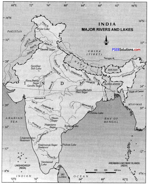
Write the names of main sources of water.
Answer:
- Rainfall
- Rivers and streams
- Canals
- Tanks
- Groundwater.
![]()
Question 7.
What is given by the natural vegetation to man?
Answer:
- Timber (wood) which is used for buildings.
- Fruit, medicines and other products.
Question 8.
Name the types of forests found in India.
Answer:
- Evergreen forests
- Deciduous forests
- Desert forests
- Mountain forests
- Delta forests.
Question 9.
What are migratory birds and where do they come from?
Answer:
In cold season birds migrate to India. These are called migratory birds. These come from Mosay Siberia and China.
II. Answer the following questions in 50-60 words :
Question 1.
Write about the land use in India.
Answer:
Land use pattern. India has a total geographical area of 32.8 crore hectares. Main characteristics of land use are given below:
- Net Sown Area. About 46% of total land (77 crore hectares) is net sown area. This vast area shows the importance of agriculture in India as crops are grown in it
- Fallow land. About 8% land (2.2 crore hectares) is left as fallow land and is cultivated after two or three years.
- Forests. About 22.2% of land is (6.6 crore hectares) under forests. It should be 33%. Afforestation be done and’ deforestation be banned.
- Plantation crops. About 1% land is under plantation crops like tea, coffee, etc.
- Other uses. Land under permanent grassland, cultivable waste and not available for cultivation amounts to about 5 crore hectares.
- Area under forests is increasing. Fallow land has been reduced in area. Net sown area under doubled cropped area is also increasing.
Question 2.
After mentioning the types of soil write the importance of alluvial soil.
Answer:
There are six types of soils in India :
- Alluvial soils
- Black soils
- Red soils
- Laterite soils
- Forest and Mountain soils
- Desert soils.
Alluvial Soils: These are made up of fine particles. These are clay soils and fertile soils. Therefore, the alluvial plains are very useful for agriculture. For example, the Indus- Ganga-Brahmputra plain of India. It has two types-Khadar and Bangar soils.
![]()
Question 3.
How is the soil resource being conserved?
Answer:
Soil Conservation. Soil is a very fundamental natural resource. Soil formation is a slow process, but it is easily lost by soil erosion. Sound farming practices and measures be adopted to conserve, protect, renew and maintain soil fertility.
These methods constitute soil conservation.
- Afforestation: Afforestation and reforestation is needed to hold the soil.
- Controlled grazing: The number of cattle to be grazed on slopes should be according to the carrying capacity of the pastures.
- Terraced agriculture: Slopes must be cut into a series of terraces (fields) for cultivation so as to slow down the flow of rain water.
- River dams: River dams are built in the upper course of rivers to control floods and check soil erosion.
- Crop rotation: Crop rotation system be applied and the land should be allowed fallow for some time. Soil fertility can be maintained in this way.
Question 4.
Give the importance of rivers and canals.
Answer:
India has a total of 1869 billion cubic metre water resources. Out of this, only 660 billion cubic metres have been utilized for irrigation. India needs to plan these water resources to be utilized for agriculture. For this more multipurpose projects should be planned and completed. Ground water resource should be used for providing water power to tubewells. A lot has been done to manage our water resources, but due to technological and financial limitations, still much of water goes waste to oceans.
Question 5.
How the water can be conserved?
Answer:
Water is a vital resource for the development of economic activities. Water should be conserved in the following ways. Waters of ocean, river and lakes should not be polluted. It should he saved from urban waste and chemicals of industries. It should be recycled to use it again. Dams should be built across the rivers and lakes to store water in reservoirs.
Question 6.
Write a note on Deciduous forests.
Answer:
Deciduous forests shed their leaves in a specific season. In spring season, these leaves become green.’These are the most widespread forests in India. These are economically very important from the point of getting timber. These include Sal, Teak, Bamboo, Shisham and Khair trees.
![]()
Question 7.
What steps have been taken by Govt, of India for protection and conservation of wildlife? (P.S.E.B. 2020)
Answer:
Wildlife plays an important role in the human progress and civilisation. The primitive man had to depend on animals for food and other basic needs. Later on, man began to domesticate animals. Still hunting is carried on in many parts of the world. Many useful and valuable species are becoming extinct due to hunting or killing of animals. Man has upset the ecological balance by killing of birds and animals.
Many steps have been taken for the preservation of wildlife.
- Parks and sanctuaries have been established in hilly areas and forests.
- Hunting of some rare species of animals has been banned.
- Public attention is focused on making efforts for the preservation of wildlife.
- Wild animals like lion, tiger, deer, etc. are protected during closed season when they cannot be hunted.
III. Answer the following questions in about 125-130 words :
Question 1.
What are Natural Resources? Write down the types and importance of soils and natural vegetation.
Answer:
Natural Resources are free gifts provided by nature. These include land, water, soil, forests, wildlife, minerals, etc.
1. Soils: The main types of soils are :
- Alluvial soils
- Black soils
- Red soils
- Laterite soils
- Forests and Mountain soils
- Desert soils.
Importance: Soil is a valuable resource. It is required for cultivation of crops. Fertile soil is the basis of developed agriculture. It becomes more important for a country like India which is an agricultural country. Many types of soils are found in India and many types of crops are grown on it.
2. Vegetation: The following types of vegetation is found in India :
- Evergreen forests
- Deciduous forests
- Desert forests
- Mountain forests .
- Delta forests.
Importance of Forests: Forests are a valuable resource like a river system, it is a multiple resource. Forests provide mankind with a number of products. Forests have greatly influenced human activities. Modem civilization depends more and more on forests.
Following are the direct and indirect advantages of forests :
- Forests provide many things to meet our food requirements like wild fruits, nuts, berries, etc. Many tribes are dependent on gathering of these products in forests.
- Forests are a source of timber for house-building, furniture-making, ship-building, etc.
- Forests supply about 40% of fuel of the world. Wood has been the major source of fuel in house smelting industries and running locomotives.
- Soft wood trees supply raw materials, wood pulp, paper, rayon industries.
- Many products like rubber, pitch, gum, tanning materials, cork, camphor, fir, herbs, etc. are gathered from forests.
- Forests provide plywood and fibre wood for packing purposes
![]()
Question 2.
How the water and wildlife can be conserved? Express your views.
Answer:
India is rich in fauna and flora. There is a great biological diversity in, India. There are about 90000 known species of animals. It has 2500 species of fish and 1200 species of birds. But many of these fauna have been destroyed by-man. Many rare species have become extinct in India. Our rich wildlife is rich heritage formed through centuries. It must be preserved. Many of the fauna are found only in India such as swamp deer, the one-horned rhinoceros, the bison, Kashmir stag, Nilgai, etc. These rare species are in danger of extinction.
The following measures have been taken for conserving and protecting wildlife as well as its bio diversity in the country. Wildlife is a gift of nature and a thing of beauty. Wildlife Act provides for the protection and conservation of these species.
For this purpose :
- A network of 89 national parks, 490 sanctuaries and 13 biosphere reserves have been established.
- Under Project Tiger 27 Tiger Projects in 14 states have been set up.
- 15 mangroves have already been identified for intensive conservation and management purpose.
Conservation and Management of Water Resources
1. Watershed Management. The management of the divide between two drainage basin called watershed is taken as a physiographic unit. The inter-basin management of water helps to divert water from surplus areas to scarcity areas. It also helps replenish ground water resources. It involves integrated development of two or diverse basins and saves on technical and financial resources.
2. Rainwater Harvesting. Rainwater is stored in roof top tanks, on ground Or underground tanks or check dams, percolation pits, etc. during rainy season and then it is used for irrigation, improving vegetation cover in dry season. While it increases productivity it also replenishes ground water resources.
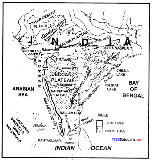
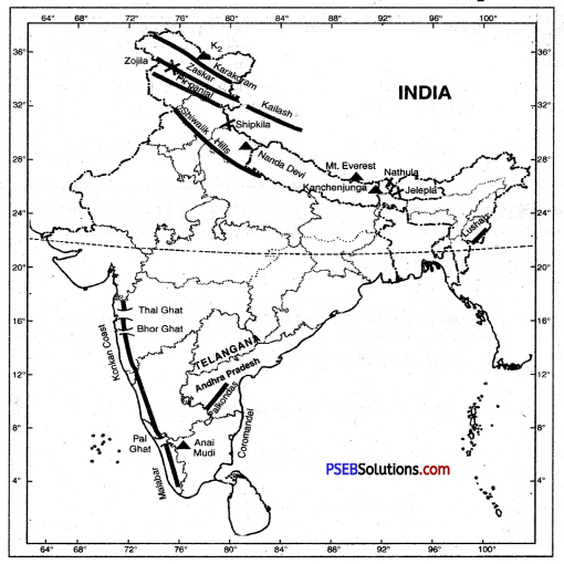
IV. Map Skill
Question 1.
Show the following on the outline map of India :
1. Northern plains of India
2. Ganga and Brahmputra Rivers
3. Region of Alluvial soils
4. A state with black soil
5. An area of evergreen forests
6. A region with mountain and delta vegetation.
Answer:
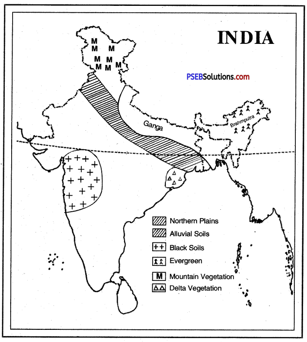
![]()
V. Activity
Question 1.
Show eight types of soils on the map of India.
Answer:
PSEB 8th Class Social Science Guide Natural Resources Important Questions and Answers
Multiple Choice Questions :
Question 1.
Which one of the following is not a type of forest found in India?
(a) Evergreen forest
(b) Tidal forest
(c) Deciduous forest
(d) Desert forest.
Answer:
(b) Tidal forest.
Question 2.
Cutting down of trees is called :
(a) Afforestation
(b) Deforestation
(c) Slash and Burn
(d) Strip cropping
Answer:
(b) Deforestation.
Question 3.
Sunderbans is the habitat of :
(a) Tiger
(b) Lions
(c) Elephants
(d) Camels
Answer:
(a) Tiger.
Question 4.
Which is the oldest landmass of India?
(a) Northern Plain
(b) Peninsular Plateau
(c) Himalayas
(d) Aravallis.
Answer:
(b) Peninsular Plateau.
Question 5.
Natural vegetation and wildlife is found in :
(a) Biosphere
(b) Hydrosphere
(c) Atmosphere
(d) None of the above.
Answer:
(a) Biosphere.
![]()
Question 6.
Following picture shows a specific type of forests, names these forests.

(a) Evergreen forests
(b) Tidal forests
(c) Deciduous forests
(d) Deserts
Answer:
(a) Evergreen forests.
Question 7.
Study the following picture and give the answer what this picture is explained?

(a) Afforestation
(b) Deforestation
(c) Slash and Burn
(d) Strip Gopping
Answer:
(b) Deforestation.
Question 8.
Jhoolan Devi does the agricultural work with her family but her family is forced to migrate to other place to do agriculture due to reduction in soil fertility. What type of farming does this situation represent?
(a) Permanent agriculture
(b) Horticulture.
(c) Intensive agriculture
(d) Jhum cultivation.
Answer:
(d) Jhum cultivation.
Question 9.
How much part of total area of India is under forests? (P.S.E.B. 2020)
(a) 11.9%
(b) 52.2%
(c) 22.2%
(d) 32.2%.
Answer:
(c) 22.2%
Fill in the Blanks :
Question 1.
In India soils are of types.
Answer:
six
Question 2.
__________ is the upper most layer of the earth crust .
Answer:
soil
Question 3.
Land use depends on __________ factor.
Answer:
physical
![]()
Question 4.
Ice-sheets are found in __________
Answer:
greenland
Question 5.
About ________% of the total surface area of the earth is under water.
Answer:
71
True/False :
Question 1.
The original rock called Parent Rock.
Answer:
True
Question 2.
Pollution means contamination of natural resources.
Answer:
True
Question 3.
A dripping tap wastes 100 litres in a year.
Answer:
False
Question 4.
An average urban Indian uses about 35 litres of water everyday.
Answer:
False
Question 5.
Land suitable for agriculture is called Arabic land.
Answer:
True.
Very Short Answer Type Questions
Question 1.
Describe the distribution of Land and Water on earth.
Answer:
29%-Land and 71%-Water.
Question 2.
Why is there need for Afforestation in India?
Answer:
There should be at least 33% area under forests in India. But only 22.2% area is under forests in India. So there is need for growing trees on large scale.
Question 3.
What do you mean by culturable waste?
Answer:
Some land is culturable, but it is not cultivated due to some reasons. Such as scarcity of water, soil erosion, waterlogging, etc.
![]()
Question 4.
In which areas forest and mountain soils are found? State any two characteristics.
Answer:
These soils are found along forests and hill slopes.
Characteristics:
- These have organic elements.
- These lack in Potash, Phosphorus, Lime. Therefore, use of fertilizer is essential.
Question 5.
What are alluvial soils?
Answer:
Alluvial soils are formed by deposition of fine sediments. These sediments are brought by the river. Sea waves also deposit these along coasts. Alluvial soils are very fertile.
Question 6.
Why is black soil called cotton soils? Name one other name of it.
Answer:
Black soil is suitable for the cultivation of cotton. So it is called cotton soil. It is also called Regur soil.
Question 7.
Where are desert soils found in India?
Answer:
Desert soils are found in Rajasthan, Punjab, Haryana and in some parts of Gujarat.
Question 8.
Why is earth called a ‘watery planet’?
Answer:
Most of the earth (71%) is covered with water. So it is called watery planet due to excess of water.
Question 9.
In which form most of water is found on earth? How much per cent is it of total water?
Answer:
Most of water is found in the form of oceans, seas and salt lakes. It contains 97.20% of total water.
Question 10.
For which purpose, most of water is used and how much?
Answer:
93.37% of total water is used for agricultural purposes.
![]()
Question 11.
Where are Tanks found?
Answer:
Tanks are found in areas where there are no perennial rivers and canals. Ground water is very deep. In India most of tanks are found in southern India.
Question 12.
Write briefly about desert vegetation.
Answer:
Desert vegetation is found in arid areas. The vegetation is scanty. It includes Date palm, Cactus and Thorny bush. In India, this type of vegetation is found in Rajasthan, Gujarat and Haryana.
Question 13.
Name four trees of mountain vegetation.
Answer:
- Fir
- Deodar
- Oak
- Nuts.
Question 14.
What is terrace farming?
Answer:
Terrace farming. The growing of crops on level steps or terraces that have been constructed on hillsides.
Question 15.
What is a wildlife sanctuary?
Answer:
A wildlife sanctuary is dedicated to protect wildlife and conserve forests.
Question 16.
What are Protected forests?
Answer:
There are forests reserved for timber but grazing is allowed subject to minor restrictions. These are 29.2% of total forests.
Question 17.
What is contour ploughing?
Answer:
Contour Ploughing: Technique of ploughing parallel to the contours of a hill slope rather than up and down the slope, so as to reduce soil erosion.
Question 18.
What is strip cropping?
Answer:
Strip Cropping. Growing of different crops on parallel narrow strips of ground, usually following the contour patterns.
![]()
Question 19.
What is a shelterbelt?
Answer:
Shelter belt: In dry regions, rows of trees are planted to check the wind movement for protecting soil cover.
Short Answer Type Questions
Question 1.
Write a note on alluvial soils. Classify these into two groups.
Answer:
Alluvial soils. These cover 45% land of India :
- Alluvial soil is deposited by rivers.
- These soils are limited to river basins and plains.
- These are very fertile soils.
- These consist of fine-grained. clay and sand.
- These soils are rich in potash, but poor in phosphorus.
- These are usually deep soils.
Types:
(a) Khadar soils
(b) Bangar soils.
(a) Khadar soils are new alluvial soils while
(b) Bangar soils are old alluvial soils.
Question 2.
State the characteristics of Black soils. Describe its distribution in India.
Answer:
Black Soils. Black soils are mainly found over the Deccan Lava tract (Deccan trap) including Maharashtra, Madhya Pradesh, Gujarat and Andhra Pradesh. These soils are found in river valleys of Narmada, Tapti, Godavari and Krishna. These soils have
been formed due to weathering of lava rocks. These soils cover an area of about 5 lakh sq. km. These soils are rich in lime, iron, magnesia and alumina. But these lack in phosphorus, nitrogen and organic matter. These are also called ‘Regur Soils’. These soils are most suitable for cotton cultivation and are known as ‘Black Cotton Soils’. These soils are compared with Chernozem soils of Russia and Prairies soils of U.S.A. These soils can hold water. These soils are suitable for rice, wheat, jawar, sugarcane, tobacco and oilseeds.
Question 3.
Write a note on desert soils.
Answer:
Desert Soils. These soils cover 2 lakh sq. km. area in dry areas of Rajasthan, Gujarat, Punjab, Haryana. These coarse soils are suitable for the cultivation of jawar, bajra, cotton, oats, maize, pulses etc. Methods of irrigation are used. These are sandy soils and are infertile. These do not hold water. So these are used for dry crops. In India 4.3% area is covered by desert soils.
![]()
Question 4.
State the characteristics and distribution of Red Soils in India.
Answer:
Red Soils: These soils are found in Chotta Nagpur plateau, Telangana, Nilgiris, Tamil Nadu, Karnataka, Andhra Pradesh and areas on periphery of Deccan Plateau. These soils have been formed due to decomposition of underlying igneous rocks under heavy rainfall. These soils have different shades of red and yellow. The red colour of these soils is due to oxidation and diffusion of iron in hard crystalline rocks. These are used for the cultivation of millets, pulses, linseed, tobacco, etc. These soils cover the largest area (10.6%) in Peninsular India, particularly S.E. part of the Peninsula. These soils are poor in lime, nitrogen and humus. Fertilizers are added to make these fertile.
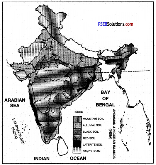
Question 5.
What are the characteristics of laterite soils? Describe its distribution in India.
Answer:
- The laterite soils are of brick colour.
- These are shallow, acidic and less fertile.
- These are less fertile due to leaching of soil.
- These are poor in nitrogen, potash but very rich in iron.
- These are found in Tamil Nadu, Western Ghats, Rajmahal hills, Vindhyas, Satpuras and Malwa plateau. These soils cover 7.5% area of the country
- Some areas of Maharashtra, Andhra Pradesh, Orissa, Karnataka, Jharkhand also have laterite soils.
- These are suitable for cultivation of Rubber, Tea, Coffee and Coconut.
Question 6.
What do you mean by wildlife? Describe in brief the wildlife of India.
Answer:
Like diverse flora, our fauna is found to be equally rich and varied. There are about 80,000 known species. The country in its fresh and marine waters has as many as 2500 species of fish. Likewise there are about 1200 species of birds. In addition there are amphibians, reptiles, mammals and small insects and worms. Migratory birds also come to India during winter
Mammals: Among the mammals, the elephant is the stately animal. It is a typical animal of hot wet equatorial forests. It is found in the jungles of Assam, Kerala and Karnataka. In these areas, it rains heavily and the forests are very dense. On the other hand camels and wild asses are found in hot deserts. Camels are found in Thar desert.
Question 7.
Why is the Land considered an important resource?
Answer:
Land is considered as an important resource because:
- It is used for different purposes like agriculture, forests, pastures.
- Human beings make their houses and live on it and also it provides most of the products they need; like food, wood etc.
Question 8.
Name the five factors controlling soil formation.
Answer:
The five factors controlling soil formation are:
- Nature of the parent rock
- Topography
- Climate
- Time
- Organism in it.
![]()
Question 9.
Write any two reasons for land degradation today.
Answer:
There are many factors which lead to the degradation of land. Both nature and human factors can lead to degradation of land.
- Growing population and their ever growing demand is the main reason of land degradation today.
- Deforestation is the another main reason of land degradation.
Question 10.
Why is land considered an important resource?
Answer:
Land is considered as an important resource because :
- It is used for different purposes such as agriculture, forest, mining, pastures, etc.
- Human beings make their houses and five on it and also it provides most of products they need like food, wood, etc.
- Human beings set up their industries, build roads and run other commercial activities.
Question 11.
What factors control the utilization of land?
Answer:
The physical and human factors control the utilization of land. These include :
- relief of features,
- climatic conditions,
- soils,
- density of population,
- technical level of the people,
- land tenure,
- duration of the occupation of the area etc.
The interplay of physical and human factors has developed many types of land uses.
Question 12.
What is terrace farming?
Answer:
Terrace farming: The growing of crops on level steps or terraces that have been constructed on hillsides.
Question 13.
What is a wildlife sanctuary?
Answer:
A wildlife sanctuary is dedicated to protect wildlife and conserve forests.
![]()
Question 14.
What are the effects of deforestation?
Answer:
The effects of deforestation are as under :
- It affects the ecosystem.
- It increases soil erosion.
- It affects underground flow of water.
- Disappearance of wildlife as well as variety of plants.
- Leads to serious deterioration of genetic reserves.
Question 15.
What are Protected forests?
Answer:
These are also forests reserved for timber but grazing is allowed subject to minor restrictions. These are 29.2% of total forests.
Question 16.
What is contour ploughing?
Answer:
Contour ploughing: Technique of ploughing parallel to the contours of a hill slope rather than up and down the slope, so as to reduce soil erosion.
Question 17.
What is strip cropping?
Answer:
Strip Cropping. Growing of different crops on parallel narrow strips of ground, usually following the contour patterns.
Question 18.
For what purposes land is used? What is land use pattern?
Answer:
Land is used for different purposes.
They are :
- Cultivation of crops agriculture.
- Grazing of animals.
- Building houses and roads.
- Mining.
- Industries.
These uses of land is commonly termed as land use pattern.
![]()
Question 19.
What is a shelterbelt?
Answer:
Shelterbelt: In dry regions, rows of trees are planted to check the wind movement for protecting soil cover.
Question 20.
Write the importance of forests.
Answer:
Importance of forests. Forests play an important role in human life. They provide food, wood and timber to us. Many medicinal plants are found in the forests. They also help in maintaining ecological balance and checking soil erosion. They play an important role in the economy of our country.
Question 21.
What is the role of insects in soil formation?
Answer:
Insects play a very important role in soil formation. Without worms and insects, the work of soil formation will be incomplete. They do it through both physical or mechanical means and speeding up chemical reactions.
Question 22.
Why does soil lose fertility?.
Answer:
The soil loses its fertility when continuously used. When crops are grown every year it loses its nutrients which are necessary for good soil.
Question 23.
What are the factors that control soil formation?
Answer:
Soil formation is controlled by five factors. These are :
- Nature of parent rock
- The topography
- The climate
- The organism in the soil
- Time.
Question 24.
What is the importance of landforms?
Answer:
Man’s economic activities differ with different landforms.
- Mountainous regions are not much suitable for human settlements.
- Dense population is found in plains.
Question 25.
‘Land plays a fundamental role.’ Discuss.
Answer:
Plains are known for agriculture and dense population. Plains, 43% area of India, fulfill man’s many needs. The agriculture depends upon plain.
Question 26.
What is fallow land?
Answer:
The land which is not used for agriculture for 1 to 5 years is left vacant. It restores the fertility of the soil. It is called fallow land.
![]()
Question 27.
Examine the importance of water.
Answer:
Water is a valuable and important resource. It is the basis of life on earth. Water fulfils many human requirements. It is used for drinking, bathing, washing and agriculture.
Question 28.
Name the major threats to be environment.
Answer:
Land degradation, landslides, soil erosion and desertification are the major threats to the environment. This is because of expansion of agriculture and construction activities.
Question 29.
Write the steps that can help in conserving degraded land.
Answer:
The following steps may help in conservation and reclamation of degraded land:
- Afforestation and control on overgrazing.
- Plantation of land reclamation of plants.
- Regulated use of chemical pesticides and fertilisers.
- Proper discharge of sewage industrial effluents.
- Maintain proper mining processes and technique.
Fill in the blanks :
Question 1.
Nearly 97% of the earth’s total water is in the form of __________ and __________
Answer:
Sea, oceans
Question 2.
Tiger park at Dudhwa is situated in the state __________
Answer:
Uttar Pradesh
Question 3.
__________ is produced with the help of running and falling water.
Answer:
Hydro-electricity
Question 4.
Polar areas are populated areas.
Answer:
sparsely
![]()
Question 5.
We can __________ the supply of drinking water by installing desalination plants.
Answer:
increase
Question 6.
In __________ areas landslides have been a major and widely spread natural disaster.
Answer:
mountains.
Long Answer Type Questions
Question 1.
What are the sources of fresh water in India? Describe each.
Answer:
Two types of water is found on earth-saline and fresh. Man uses freshwater for different purposes. Its sources are :
1. Rainfall. Rainfall is the major source of water on the earth. Some water is evaporated, some water flows down to the oceans and some water goes underground through percolation. India has average annual rainfall of 118 cm.
Rain water or running water flowing on the surface of land is called surface water. It includes water in oceans, seas, lakes, rivers, etc. India’s total surface water resources are 1869 billion cubic metres.
2. Ground Water. Rain water that goes beneath the surface of the earth by percolation is called ground water. India has a total ground water resources of 40 million hectare metres. This water can be obtained by digging wells. Sometimes it comes out through springs also.
3. Rivers and Canals. From early periods, rivers and canals have been very important. Many civilisations developed along river banks. Man built dams on rivers to use water for irrigation through canals.
4. Tanks. Tanks are found in areas deficit in rainfall. The water level is very deep so it is difficult to use it. Rain water is collected in depressions called tanks. Tanks are mostly found in southern India.
![]()
Question 2.
What do you mean by Natural Vegetation? On what factors does it depend? Describe the different types of forests found in India.
Answer:
Natural vegetation includes plants and trees which grow automatically according to climate. It depends upon climate, soil, drainage, temperature, rainfall and altitude.
We can divide India into the following vegetation belts :
- The Tropical Rain Forests.
- The Tropical deciduous or the Monsoon forests.
- The Thorn Forests.
- The Tidal Forests.
- Mountain Forests.
1. The Tropical Rain Forests are of two varieties: evergreen and semi-evergreen. Regions having more than 300 centimetres of rainfall have evergreen forests. The hills of Assam and the rainy slopes of the Western Ghats are such areas. The region where the rainfall is between 200 and 300 centimetres have semi-evergreen forests. Such areas are there in Assam, West Bengal, Orissa and in Western Ghats.
2. The Tropical Deciduous or Monsoon Forests are found in the regions where rainfall is between 100 and 200 centimetres. Teak and sal are the most important trees of monsoon forests besides sheesham, mahua, bamboo, etc. The belt of monsoon forests extends from the Western Ghats in the south to the Shiwalik hills in the north.
3. The Thorn Forests are found in Rajasthan, Haryana, Punjab, Gujarat, dry parts of Madhya Pradesh and the Deccan, where the rainfall is less than 80 centimetres. Kikar, Babool and Wild Palm are the common trees of this type of forests.
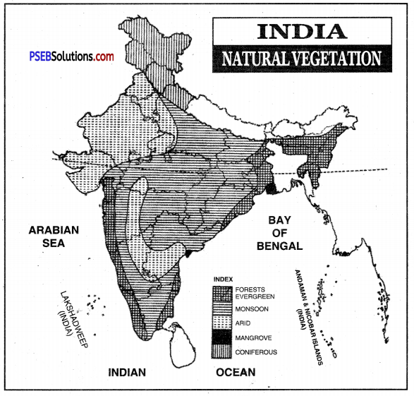
4. The Tidal Forests are mainly found along the river deltas. Mangrove and Sundri trees are the common trees found in the Ganga delta in Bengal which is also “called the Sundarban.
5. The Mountainous Forests. The foothills of the Himalayas are covered with tropical deciduous forests. At high slopes, oak, chestnuts, chir, pine trees of sub-tropical type are formed. At a height of 3300 metres, coniferous forests like blue pines, cedars silver firs, deodars are found. Alpine pastures are found at high altitudes.
Question 3.
Write a short note on conservation of soils.
Answer:
Soil Conservation. Soil is a fundamental natural resource. Soil formation is a slow process, but it is easily lost by soil erosion. In fact, more soil is being lost each year than nature makes. Soil erosion must be checked. Sound farming practices and measures be adopted to conserve, protect, renew and maintain soil fertility.
These methods constitute soil conservation.
1. Afforestation: In some areas, the original vegetation cover has been removed such as in Shiwalik hills. In such areas afforestation and reforestation is needed to hold the soil. Advance of deserts can be checked by planting trees along the margins of deserts.
2. Controlled grazing: The number of cattle to be grazed on slopes should be according to the carrying capacity of the pastures.
3. Terraced agriculture: Slopes must be cut into a series of terraces (fields) for the cultivation so as to slow down the flow of rain water.
4. Contour Ploughing: It is done to check soil wash on slopes. Ploughing is done at right angles to the hill slopes.
5. Crop rotation: Crop rotation system be applied and the land should be allowed fallow for some time. Soil fertility can be maintained in this way.
![]()
Question 4.
Distinguish between Evergreen Forests and Deciduous Forests.
Answer:
| Evergreen Forests | Deciduous Forests |
| 1. Evergreen forests are found in regions that experience tropical climate throughout the year. | 1. Deciduous forests are found in regions that experience rainy and dry season. |
| 2. They do not shed their leaves in any season of the year. | 2. They shed their leaves once a year. |
| 3. Their height exceeds 60 metres. | 3. They are less than 50 metres in height. |
| 4. They have less economic importance as the wood from them is very hard and is of not much use. | 4. They have more economic value, as their wood is soft and durable. |
| 5. Some trees are ; Rosewood, Mahogany etc. | 5. Some trees are ; Teak, Sal, etc. |
Question 5.
What is the most important feature of the Landuse pattern in India?
Answer:
- India has total geographical area of 828 million sq. km. (3280 lakh hectares). The land use data is available for about 93% of the total area. It shows that 151 million hectares (47%) is net sown area. Thus India has a very high percentage (47%) of total area under cultivation. No other big country has such a large area under cultivation.
- Another satisfying feature is that only 8% of land is fallow which is not cultivated so as to restore the fertility of the land. It is notable that fallow land has risen to 8% from earlier figure of 5%. It reflects that care for land resources has become essential.
- The area under pastures is also small (4%).
- The area under cultivable waste is 5%. This wasteland can be brought under cultivation to increase productivity.
- The forest cover is low, only 22%. It is desirable to have about one third of the total land area under forests to maintain a healthy environment.
Question 6.
Explain the factors controlling soil formation.
Answer:
Soil formation is controlled by five factors :
- nature of parent rock,
- the topography,
- the climate,
- the organism in the soil and
- time.
1. Parent Rock: The original rock called parent rock, from which the soil is formed, determines its basic characteristics. For example, shales contribute clays, while sandstones contribute sand grains.
2. Climate: Temperature and precipitation are the main climatic factors affecting soil formation. Frequent temperature changes and presence of water quicken soil formation through increased weathering.
3. Topography: Topography affects the drainage of an area. On a steep slope, there is hardly any chance of accumulation of weathered rocks. They are moved down the slope by water and under force of gravity. In plains and areas with gentle slope, soils are accumulated without any hindrance.
4. Organisms: Dead plants and animals provide humus to soil. Organisms like earthworms and ants through their movements create space for air and water in the soil.
5. Time: Time factor is also important because longer the time for soil formation, more deeper is the soil layer. Besides weathering of rocks, soil is also formed by deposition of materials by moving waters (rivers) and winds in low-lying areas. Alluvial soils of river valleys are very fertile and deep.
Question 7.
What are water resources? What are their uses?
Answer:
Water Resources. Water is a unique liquid because there is no alternative for it. It is essential for all forms of life. Compared to most other liquids, water has a high capacity to absorb or store heat.
Water is a major body constituent of several plant and animal species. Seventy percent of the human body consists of water. Humans use water for several purposes—domestic (drinking, cooking, washing, etc.), agricultural (irrigation), industrial and generation of electricity.
![]()
Question 8.
How are vegetation and wildlife useful for us?
Answer:
Vegetation and wildlife are valuable resources
1. Plants provide us
- Timber, fruits, nuts, latex, oil, gum, medicinal herbs, etc.
- Shelter for animals and birds.
- Protect soil and storage and water.
- Oxygen to breathe.
2. Wildlife provides us
- with milk, meat, hides, wool, honey.
- helps as decomposers, act as scavengers.
- maintain the ecological balance.
- The birds feed on insects and act as decomposers as well.
- Vulture each dead livestock and act as scavengers. They are considered as a vital cleaner of environment.