Punjab State Board PSEB 6th Class Social Science Book Solutions Geography Chapter 2 Globe – The Model of the Earth Textbook Exercise Questions and Answers.
PSEB Solutions for Class 6 Social Science Geography Chapter 2 Globe – The Model of the Earth
SST Guide for Class 6 PSEB Globe – The Model of the Earth Textbook Questions and Answers
I. Answer the following questions in brief:
Question 1.
Why is Globe called a model of the Earth?
Answer:
Globe shows the earth in its true shape. The shapes and sizes of all the physical features of the earth such as continents and oceans, distances and directions, etc. are correctly represented on it. As such, it is a correct replica of the round shape of the earth. That is why Globe is called a model of the earth.

Globe
Question 2.
What is the name of the ending of screw of Globe?
Answer:
The upper screw of Globe is known as North Pole and lower one is called South Pole.
Question 3.
What is the name given to the semi-circles that connect both the poles?
Answer:
The semi-circles that connect both the poles are named as longitudes.
Question 4.
What is Hemisphere? Name the line that cuts the Globe or Earth into the Hemispheres.
Answer:
The half of a sphere is called hemisphere. The equator cuts the Globe or Earth into the hemispheres.
![]()
Question 5.
What is the Prime Meridian? From where it passes?
Answer:
0° longitude is called the Prime Meridian. It passes through Greenwich in England.
Question 6.
What is the difference between Longitudes and Latitudes?
Answer:
Longitudes are angular distances of a place from the Prime Meridian, whereas latitudes are angular distances of a place from the equator.
Question 7.
Why longitudes are called Meridians of Longitude? Into how many Meridians do we divide the Earth or Globe?
Answer:
Longitudes are called Meridians of Longitude because they are drawn through the Prime Meridian. We divide the Earth or Globe into 360° meridians.
Question 8.
Which is the largest circle of Globe? Name it.
Answer:
The circle of equator is the largest circle of Globe.
Question 9.
What is the difference between Parallels of Latitude and Meridians of Longitude?
Answer:
| Parallels of Latitude | Meridians of Longitude |
| 1. Parallels of latitude are imaginary circles drawn parallel to the equator. | 1. Meridians of longitude are imaginary lines running from North to South. |
| 2. These are circles. | 2. These are semi circles. |
| 3. The distance between them is measured in degrees of latitude. | 3. The distance between them is measured in degrees of longitude. |
| 4. They are 180+1 in number. | 4. They are 360 in number. |
Question 10.
What is the importance of Longitudes?
Answer:
The importance of longitudes is as follow :
- Longitudes help us in knowing the east-west distance of a place.
- They help us in calculating the local time of a place.
Question 11.
Which lines help us to divide the Earth into Heat Zones? Give reasons why there are Heat Zones.
Answer:
Latitudes help us to divide the earth into Heat Zones. Heat Zones are there because of the following reasons :
1. The rays of the sun which are vertical, occupy less space but intensity of heating is very high and the rays of the sun which are slanting, occupy more space but intensity of heating is low.
2. The shape of the earth is spherical. The central, the bulging part of the earth receives maximum heat of the sun and as we go away from the central part towards the poles, the heat reduces.
Question 12.
What is the difference between Local Time and Indian Standard Time?
Answer:
1. Local Time. Local time is the time reckoned by the noon sun at a given place. At any place a watch can he adjusted to read 12 O’ clock when the sun is at the highest point in the sky or when it is mid day. The time shown by such a watch will give the local time for that place. All the places, on a given meridian of longitude, have the same local time.
2. Indian Standard Time. In a particular country, local time of a particular or rather a central place is adopted as the uniform time for the whole country. It is called the standard time of that country or that area. In India, the local time of 8214 ° E Longitude is used as the standard time for the whole country. It is called the Indian Standard Time. 8214° E is thus the standard meridian of India.
II. Fill in the blanks :
Question 1.
Tropic of Cancer is depicted by ________ Parallel of Latitude.
Answer:
0 to 23 1/2° North
Question 2.
Tropic of Capricorn is depicted by ________ Parallel of Latitude.
Answer:
0 to 23 1/2° South
![]()
Question 3.
Latitudes and Longitudes make a on a Globe.
Answer:
grid
Question 4.
The distance between any two parallels is always ________
Answer:
equal
Question 5.
The ________ is also known as Zero Meridian.
Answer:
Prime Meridian
Question 6.
In India, the Longitude of ________ is considered the Standard Meridian.
Answer:
82 1/2° East
Question 7.
The time difference between Greenwich Mean Time and Indian Standard Time is ________
Answer:
5 hours 30 minutes.
III. Say whether the following statements are True or False :
Question 1.
Each parallel of Latitude is a semi-circle.
Answer:
False
Question 2.
Temperature increases as we go away from the equator.
Answer:
False
![]()
Question 3.
The Torrid Zone lies between the Tropic of Cancer and Tropic of Capricorn.
Answer:
True.
Question 4.
The Earth rotates from the West to East direction.
Answer:
True.
IV. Things To Do (Activity):
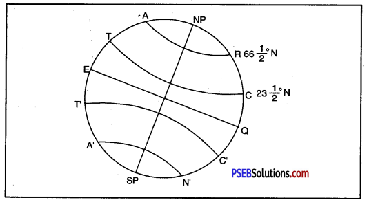
Question 1.
Draw a diagram of the earth, liark the earth’s Axis, the Great Circle, Tropic of Cancer, Tropic of Capricorn, Arctic Circle and Antarctic Circle on it.
Answer:
- N.P. – S.P. = Axis
- EQ = Great Circle
- TC = Tropic of Cancer
- T’C’ = Tropic of Capricorn
- AR = Arctic Circle
- A’N’ = Antarctic Circle.
PSEB 6th Class Social Science Guide Globe – The Model of the Earth Important Questions and Answers
Multiple Choice Questions :
Question 1.
As earth is a globe, most accurate model of it is :
(A) Map on chart
(B) Globe
(C) Map on spherical fruit
(D) Map on a circular paper.
Answer:
(B) Globe.
Question 2.
A system of orbiting satellites that send radio signals to receivers on earth is a
(A) Navigator
(B) Radio
(C) Radar
(D) GPS.
Answer:
(D) GPS.
![]()
Question 3.
A great circle is a circle which passes through the centre of the earth and bisects it into two equal hemispheres is called :
(A) Arctic circle
(B) Antarctic circle
(C) Great circle
(D) Equator.
Answer:
(C) Great circle.
Question 4.
The ends of the axis are called :
(A) Equator
(B) Poles
(C) Great Divide
(D) Great Circle.
Answer:
(B) Poles.
Question 5.
The zone with moderate temperatures is called :
(A) Temperate zone
(B) Tropical zone
(C) Equatorial zone
(D) None of these.
Answer:
(A) Temperate zone.
Fill in the Blanks :
Question 1.
The tropic of capricorn is located at ________
Answer:
23% south of equator
Question 2.
The standard meridian of India is ________
Answer:
82’4° East,
Question 3.
The 0° meridian is also known as ________
Answer:
Prime meridian
![]()
Question 4.
The distance between the longitudes decreases towards ________
Answer:
Poles
Question 5.
The arctic circle is located in the hemisphere.
Answer:
Northern.
True/False :
Question 1.
Frigid zone lies between the arctic circle and the north pole.
Answer:
True
Question 2.
With longitudes we can divide the earth into heat zones.
Answer:
False
Question 3.
Local time is the time of a central meridian of an area.
Answer:
False
Question 4.
Latitude is the angular distance of a place north to south of the equator.
Answer:
True
![]()
Question 5.
I.S.T. is termed as Indian Standard Time.
Answer:
False
Very Short Answer Type Questions
Question 1.
Name the two Hemispheres.
Answer:
The two Hemispheres are Northern Hemisphere and Southern Hemisphere.
Question 2.
What is Northern Hemisphere?
Answer:
The northern and upper part of Globe from equator is called Northern Hemisphere.
Question 3.
What is Southern Hemisphere?
Answer:
The southern and lower part of Globe from equator is known as Southern Hemisphere.
Question 4.
Explain Parallel Lines.
Answer:
Parallel lines’are those lines which run at equal distance and never meet with each other. They may be straight or circular.
Question 5.
What is Equatorial Line?
Answer:
The line drawn through the centre or 0° latitude is known as Equatorial Line.
Question 6.
How many Parallels of Latitude are there?
Answer:
There are 180+1 Parallels of Latitude.
Question 7.
What degree of angle does the equator represent?
Answer:
The equator represents 0° latitude.
![]()
Question 8.
What does 90° South Latitude indicate?
Answer:
90° South Latitude indicates South Pole.
Question 9.
Where does the Tropic of Cancer lie on Globe?
Answer:
The Tropic of Cancer lies in the Northern Hemisphere on Globe.
Question 10.
What is the angular distance of the Tropic of Cancer from the equator?
Answer:
The angular distance of the Tropic of Cancer from the equator is 231/4° North.
Question 11.
What is the angular distance of the Tropic of Capricorn from the equator?
Answer:
The angular distance of the Tropic of Capricorn from the equator is 2354° South.
Question 12.
What is the Indian Standard Time?
Answer:
The Indian Standard Time is taken in the longitude of 8214° E.
Question 13.
Which area on the earth receives the maximum heat?
Answer:
The area lying between the Tropic of Cancer and the Tropic of Capricorn receives the maximum heat.
Question 14.
Into how many Heat Zones has the earth been divided?
Answer:
The earth has been divided into three Heat Zones.
![]()
Question 15.
What is the basis of the division of Heat Zones?
Answer:
Temperature is the basis of the division of Heat Zones.
Short Answer Type Questions
Question 1.
Distinguish between Northern Hemisphere and Southern Hemisphere.
Answer:
| Northern Hemisphere | Southern Hemisphere |
| 1. The part of the earth which lies in the northern part of equator is called Northern Hemisphere. | 1. The part of the earth which lies to the south of the equator is called Southern Hemisphere. |
| 2. 0° to 90° North latitude mark Northern Hemisphere. | 2. 0° to 90° South latitude mark Southern Hemisphere. |
Question 2.
Distinguish between Latitude and Longitude.
Answer:
| Latitude | Longitude |
| 1. Latitude is the angular distance of a place North or South of the Equator. | 1. Longitude is the angular distance of a place East or West of Prime Meridian. |
| 2. The latitude value increases in North-South directions from the Equator. | 2. The longitude value increases in East-West directions from meridian. |
| 3. Its value ranges between 0° to 90° N, 0° to 90°S. | 3. Its value ranges between 0° to 180°E, 00 to 180°W. |
![]()
Question 3.
Distinguish between Local and Standard Time.
Answer:
| Local Time | Standard Time |
| 1. Local time of a place is the time of its meridian. | 1. Standard time is the time of a central meridian of an area. |
| 2. Each place has its own local time. | 2. All places have a uniform or same time. |
| 3. When it is noon, the local time is 12 o’clock. | 3. It has not any relation with noon or height. of the sun. |
| 4. All places on the Meridian have same local time. | 4. All places within a country have the same standard time. |
| 5. The places in the East are ahead of west in time. For 10 longitude there is difference of 4 minutes of time. | 5. There is no change in time. So it is known as standard time. |
Question 4.
In which hemisphere does the Tropic of Cancer lie?
Answer:
The Tropic of Cancer lies in the Northern Hemisphere. It is at an angular distance of 23’A° North from the equator. It runs in an east-west direction almost mid-way through our country.
Question 5.
What are Temperate Zones?
Answer:
The areas bounded by the Tropic of Cancer and the Arctic Circle in the Northern Hemisphere and the Tropic of Capricorn and the Antarctic Circle in the Southern Hemisphere are called Temperate Zones.
Question 6.
What are Frigid Zones?
Answer:
The areas lying between the Arctic Circle and the North Pole in the Northern Hemisphere and the Antarctic Circle and the South Pole in the Southern Hemisphere are known as Frigid Zones.
![]()
Question 7.
Where is Greenwich? For what is it famous?
Answer:
Greenwich lies near London in England. It is the place where British Royal Observatory is located. Greenwich Mean Time (GMT) has been fixed here.
Question 8.
Discuss the importance of Grid.
Answer:
The importance of Grid is as follows :
1. Grid helps us in making maps and atlases.
2. It helps us in reading maps.
3. It helps us in fixing the boundary between two countries.
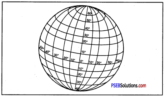
Grid
Question 9.
What is the importance of Latitudes?
Answer:
The importance of latitudes can be discussed as under :
1. We can very easily form an idea of the temperature of a place.
2. We can divide the earth into Heat Zones.
3. We can find the exact location of a place.
Question 10.
Why do we use models to show earth?
Answer:
The earth is very large in size. We cannot’ see the whole of the earth in its actual size and shape in one go. So we use models, photographs, and maps to see the earth.
Question 11.
Why is the globe a correct replica of the earth?
Answer:
On the globe, shapes, sizes, distance and directions of continents and oceans are correctly represented.
Question 12.
How many parallels of latitude are there?
Answer:
There are 90 imaginary lines drawn to the north of equator and 90 imaginary lines drawn to the south of equator. It makes 181 parallels of latitude in all.
![]()
Question 13.
How to locate a place on it (The Earth/Globe)?
Answer:
If we want to locate a place on the globe we have to do the following exercise :
- First we have to know the latitude and longitude of that place.
- Now we draw the meridian and parallel of latitude of that place on the basis of its longitude and latitude.
- The point where these meridian and parallel of latitude intersect themselves, will be the location of that place.
Question 14.
Do you know what is the time difference between India and England?
Answer:
The time difference between India and England is of 5.30 hours.
1. If it is noon in England, it is 5.30 p.m. in India because time is ahead in India than in England by 5.30 hours.
2. This can be calculated in the following manner :
- Difference between 0° longitude and 82 1/4° E longitude = 82 1/4°
- Time in the East is ahead by 4 minutes on passing every meridian
- Hence time ahead 82 1/4° × 4 = 330 minutes or 5.30 hours.
Long Answer Type Questions
Question 1.
In what way is a globe different from maps?
Answer:
Globe is a true jnodel of the earth while a map is a picture of the earth. A globe has three dimensions, while a map has two dimensions. Globe gives correct idea of shape of the earth, but a map gives details of an area. It is easy to carry maps, but globes are not portable. Globe is not*fixed. It can be rotated while map is fixed. A globe can be rotated as a top spin or a potter’s wheel. On the globe, countries, continents and oceans are shown in their correct size.
![]()
Question 2.
List the situation in which the globe is far more useful than maps.
Answer:
- Earth is truly shown by a globe. It gives shapes and directions correctly.
- It is a true model of our planet.
- Lines of latitudes and longitudes are shown correctly on a globe.
- NoW-a- days relief features can be shown on globe.
- It can be rotated on its axis.
- Globe is an important tool of Geography.
- Globe can be rotated like a top spin or a potter’s wheel.
Question 3.
What are the shortcomings of a globe?
Answer:
A globe has some limitations :
- It is not easy to carry globes.
- It is not useful for studying an area of a country.
- Only one hemisphere can be studied from a globe.
- Distances cannot be measured on a spherical globe.
- Globes do not show details.
Question 4.
Into how many Heat Zones can tile earth be divided? Explain each zone.
Answer:
The earth can be divided into three Heat Zones. They are Torrid Zone, Temperate Zone and Frigid Zone.
1. Torrid Zone: It lies between the Tropic of Cancer and the Tropic of Capricorn. It is the hottest zone of the world. The noon sun shines vertically over this part of the earth.
2. Temperate Zone: It lies between the Tropic of Cancer and the Arctic Circle in the Northern Fig. Heat Zones of Earth
Hemisphere and between the Tropic of Capricorn and the Antarctic Circle in the Southern Hemisphere. The sun is never overhead in this zone. It is neither very hot in summer nor very cold in winter. It is, therefore, called the Temperate Zone.
3. Frigid Zone: It lies between the Arctic Circle and the North Pole in the Northern Hemisphere and the Antarctic Circle and the South Pole in the Southern Hemisphere.
Question 5.
Describe the important Parallels of Latitude.
Answer:
The Equator, the Tropic of Cancer, the Tropic of Capricorn, the Arctic Circle, and the Antarctic Circle is the important Parallels of Latitude.
- The Equator: The equator is the most important parallel of latitude. It divides the earth into two equal parts. These parts are the Northern Hemisphere and the Southern Hemisphere. It is the largest possible circle that can be drawn around the earth.
- The Tropic of Cancer: It lies in the Northern Hemisphere at 23°30′ latitude. It is an angular distance of 2314° N from the equator.
- The Tropic of Capricorn: It is also an imaginary circle measuring the angular distance of 23/4° to the south from the central point of the equator.
- The Arctic Circle: It is the parallel of latitude that lies at a distance of 6614° North of the equator.
- The Antarctic Circle: It lies in the Southern Hemisphere and is at 66!4° South to the equator.
![]()
Question 6.
How do longitudes help us in calculating time?
Answer:
Longitude and Time.
- Longitudes help us to calculate time.
- It takes 24 hours for the earth to complete one rotation.
- This means in 24 hours the Earth completes 360°.
- Hence, it takes about 4 minutes for crossing one degree of longitude.
- This means each place has a different time of Sunrise and Sunset.
- Places East of the Greenwich Meridian experience day or sunrise earlier than the places lying west of this Meridian.
In other words, time is ahead in the east than that in the west, at the rate of 4 minutes per degree of longitude.