PSEB 9th Class SST Solutions Geography Chapter 1b Punjab: Size and Location

Punjab State Board PSEB 9th Class Social Science Book Solutions Geography Chapter 1b Punjab: Size and Location Textbook Exercise Questions and Answers.

PSEB 9th Class Social Science Solutions Geography Chapter 1b Punjab: Size and Location

SST Guide for Class 9 PSEB Punjab: Size and Location Textbook Questions and Answers

Map Work :

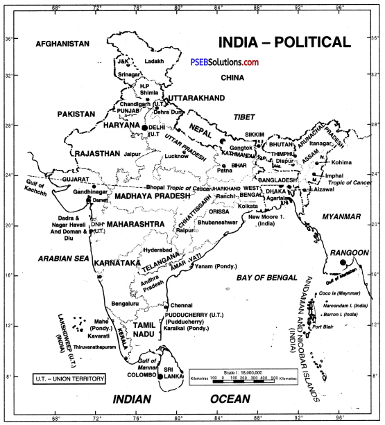
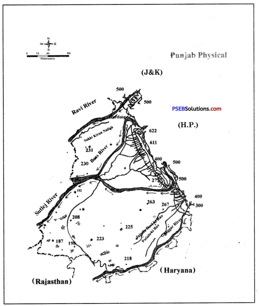
Show in an outline map of Punjab:
(i) Six districts of Punjab adjoining the international border.
Answer:
Do it yourself with the help of India Map.

(ii) The capital and 22 District headquarters of Punjab.
Answer:
Do it yourself with the help of India Map.

Objective Type Questions :
Answer the following questions in a single word to one sentence length :

Question 1.
What is literary meaning of word Punjab?
Answer:
The word Punjab is made up of two Persian words-Punj and Aab which mean five rivers.

Question 2.
Give full form of PEPSU.
Answer:
Patiala and East Punjab States Union.

Question 3.
What are Latitudinal and Longitudinal extent of Punjab?
Answer:
The Latitudinal extent of Punjab is 29°30′ N to 32°32′ N and its Longitudinal extent is 73° 55′ E to 76°50′ E.

Question 4.
What are ancient names of Ravi, Beas and Satluj?
Answer:
Purushivi, Vipasha and Satudari are the ancient names of Ravi, Beas and Satluj respectively.

PSEB 9th Class SST Solutions Geography Chapter 1b Punjab: Size and Location

Question 5.
Which of the following districts do not touch International boundary?
(i) Pathankot
(ii) Faridkot
(iii) Fazilka
(iv) Taran Taran.
Answer:
Faridkot.

Question 6.
Which Pair among the following is not correct :
(i) Batala : Agricultural Implements Industry
(ii) Jalandhar : Sports Material in Industry
(iii) Abohar : Musical Instruments Industry
(iv) Gobindgarh : Iron Furnaces Industry
Answer:
Abohar : Musical instruments Industry.

Short Answer Questions :
Give short answers for the following Questions:

Question 1.
Name any six non-private Universities of Punjab and their place of location.
Answer:

  1. Guru Nanak Dey University-Amritsar
  2. I.K. Gujral Punjab Technical University-Kapurthala
  3. Punjab University-Chandigarh
  4. Punjab Agriculture University-Ludhiana
  5. Central University of Punjab-Bathinda.
  6. Punjabi University-Patiala.

Question 2.
What is the geographical location of Punjab and its neighbourhood?
Answer:
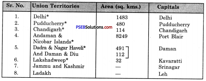
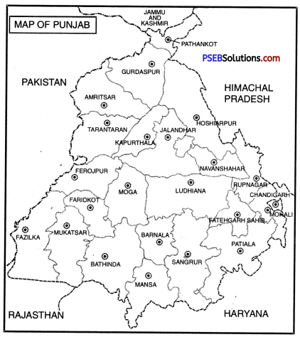
Present Punjab is extended from 29°30’ North Latitude to 32°32 North Latitude and 73°55’ East Longitude to 76°50’ East Longitude. Total geographical area of Punjab is 50,362 Sq. km which is 1.6 % of India’s total area. Punjab holds 20th position among Indian states from geographical point of view. Present Punjab is situated in the north-east of Punjab. Pakistan is in its north direction and Himachal Pradesh is in north-east direction. Haryana is situated in its south and Rajasthan is situated in its south-west direction.

Question 3.
How many divisions, districts, tehsils and blocks are there in Punjab?
Answer:
There are 5 divisions, 22 districts, 91 tehsils and 150 blocks in Punjab.
PSEB 9th Class SST Solutions Geography Chapter 1b Punjab Size and Location 1

Question 4.
Write a note on PEPSU.
Answer:
The complete name of PEPSU is Patiala and East Punjab States Union. It was constituted on 15th July, 1948 by combining the principalities of Patiala, Nabha, Malerkotla, Jind, Kapurthala, Nalagarh and Kalsia. In 1956, all the Indian states were reorganised and PEPSU was added into Punjab.

PSEB 9th Class SST Solutions Geography Chapter 1b Punjab: Size and Location

Question 5.
If we want to go to Fazilka from Pathankot without touching any border district, what way shall you follow?
Answer:
For this, we have to cross through the following districts : Pathankot → Hoshiarpur → Kapurthala → Moga → Faridkot → Shri Muktsar sahib → Fazilka.

Long Answer Questions :
Answer the following Questions in detail:

Question 1.
Introduce with geographical history of Punjab.
Answer:
The boundaries of the Punjab territory varied from time to time throughout its history.

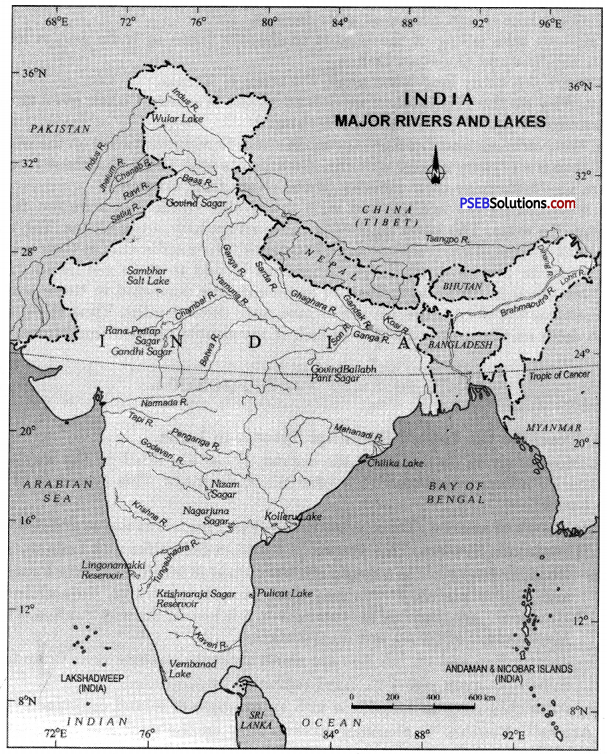
  1. According to the Rig-Veda, the boundaries of Punjab included the regions covered by the rivers Indus, Jhelum, Chenab, Ravi, Beas, Satluj and Saraswati.
  2. During the Mauryan and Kushan periods, the boundaries of Punjab extended upto Hindukush mountain ranges and Taxila.
  3. During the Sultanate period (1206-1526), the boundaries of Punjab extended from Lahore to Peshawar, During the Mughal period (1526-1707), the Punjab was divided into two provinces, namely, Lahore Suba and Multan Suba.
  4. During the reign of Maharaja Ranjit Singh, the boundaries of Punjab extended from the river Satluj to Peshawar.
  5. The British named the territory of Lahore kingdom of Maharaja Dalip Singh (son of Maharaja Ranjit Singh) as the Punjab after annexing it to the British Indian Empire.
  6. After the partition of India, a major part of the Punjab was transferred to Pakistan.
  7. On the basis- of language, Punjab was divided into three states namely Punjab, Haryana and Himachal Pradesh.

Question 2.
Give summarised information about any five districts falling in malwa region.
Answer:
The description of major districts of Malwa region is given below :

  1. Barnala. Once Barnala was a part of the Patiala kingdom. In 2006, it was made a separate district. According to census survey of 2011, Barnala was the least populated district of Punjab.
  2. Bathinda. Bathinda is known as the heart of Malwa region. Its mention also exists in the writings of famous traveller Ibn Battuta. First female Muslim ruler Razia Sultan stayed in Bathinda for some time. Presently Bathinda is a major railway junction.
  3. Faridkot. Faridkot district was made in 1972 on the name of famous Sufi Saint Baba Farid. In 1995, two more districts were carved out of the same district.
  4. azilka. Fazilka was the 21st district situated in the cotton belt. This district is famous for the production of Kinnow and other fruits.
  5. Firozpur. Firozpur is one of the historical cities and quite an old district. It was also a district even before independence.
  6. Ludhiana. Ludhiana was established in 1480 by the Lodhi rulers. Now it is famous for hosiery goods and for Punjab Agriculture University.
  7. Mansa. Mansa was made a district in 1992. It is famous for the production of cotton. It is also known as the land of white gold.
  8. Moga. It was made 17th district of Punjab in 1995. During the British times, it was the second largest centre of Christians after Ludhiana.
  9. Shri Muktsar Sahib. It is one of the historical cities and was made a district in 1993.
  10. Sangrur. Sangrur was the capital of Jind principality.

PSEB 9th Class SST Solutions Geography Chapter 1b Punjab: Size and Location

Question 3.
Which centres have developed as cottage or small scale Industries in Punjab, Introduce those?
Answer:
From industrial point of view, Punjab is a developing state. Its industries are continually developing. Many of its cities, places are important because of their small scale industries. Their brief description is given below.

  1. Batala. Batala is a city in Gurdaspur district. It was developed because of the industries of agricultural implements.
  2. Mahilpur. It is one of the towns of Hoshiarpur district and is famous for its football industry.
  3. Tanda. Tanda is also in Hoshiarpur district. It is famous for the industries of furniture and musical instruments.
  4. Sansarpur. It is one of the villages in Jalandhar district and is quite famous as nursery of hockey players.
  5. Sahibzada Ajit Singh Nagar. This city is also known as Mohali and is a major centre of many small industries.
  6. Ludhiana. Ludhiana is one of the largest districts of Punjab. It was developed with the development of Hosiery and Cycle industry.
  7. Jalandhar. It is one of the main districts of Punjab and has developed as a centre of furniture and sports goods.

PSEB 9th Class Social Science Guide Punjab: Size and Location Important Questions and Answers

Multiple Choice Questions :

Question 1.
What was the name of Punjab during the times of Maharaja Ranjit Singh?
(a) PEPSU Suba
(b) Tak Pradesh
(c) Lahore Suba
(d) Panjnad.
Answer:
(c) Lahore Suba.

Question 2.
Which country is situated in the West of Punjab?
(a) Pakistan
(b) China
(c) Myanmar
(d) Bhutan.
Answer:
(a) Pakistan.

Question 3.
Which of these districts is not included in Doaba region of Punjab?
(a) Jalandhar
(b) Amritsar
(c) Hoshiarpur
(d) Kapurthala.
Answer:
(b) Amritsar.

PSEB 9th Class SST Solutions Geography Chapter 1b Punjab: Size and Location

Question 4.
Which of these districts of Punjab was also a district even before 1947?
(a) Faridkot
(b) Ludhiana
(c) Patiala
(d) Firozpur.
Answer:
(d) Firozpur.

Question 5.
Which of these districts is the smallest district of Punjab?
(a) Sangrur
(b) Patiala
(c) Pathankot
(d) Fazilka.
Answer:
(c) Pathankot.

Fill in the blanks :

Question 1.
There are ___________ administrative divisions in Punjab.
Answer:
5

Question 2.
There are ___________ districts in Punjab.
Answer:
22

Question 3.
The earlier name of Roopnagar was ___________
Answer:
Ropar

PSEB 9th Class SST Solutions Geography Chapter 1b Punjab: Size and Location

Question 4.
Sahibzada Ajit Singh Nagar is known by the name of ___________
Answer:
Mohali

Question 5.
Total area of Punjab is ___________ sq. km.
Answer:
50,362.

True/False:

Question 1.
Razia Sultan stayed for sometime in Bathinda.
Answer:
True

Question 2.
Jalandhar is known as Riyasti city.
Answer:
False.

Question 3.
In Rigveda, Punjab was known as Sapt Sindhu.
Answer:
True

Question 4.
PEPSU was formed in 1948.
Answer:
True

PSEB 9th Class SST Solutions Geography Chapter 1b Punjab: Size and Location

Question 5.
States were reorganised in 1950.
Answer:
False.

Very Short Answer Type Questions

Question 1.
Punjab is known as the place of which civilisation?
Answer:
Indus Valley Civilisation.

Question 2.
With which name Punjab was known in Rigveda?
Answer:
Sapt Sindhu or land of seven rivers.

Question 3.
Who gave the name of Pentapotamia to Punjab?
Answer:
Greeks.

Question 4.
What is meant by Pentapotamia?
Answer:
Land of five rivers.

Question 5.
Presently, how many and which rivers flow through Punjab?
Answer:
Three rivers – Sutlej, Ravi and Beas.

PSEB 9th Class SST Solutions Geography Chapter 1b Punjab: Size and Location

Question 6.
When was PEPSU state organised?
Answer:
15 July, 1948.

Question 7.
Tell the expansion of Punjab during the times of Maharaja Ranjit Singh.
Answer:
During the times of Maharaja Ranjit Singh, Punjab was spread from Kabul (Afghanistan) in north west to Sutlej river.

Question 8.
According to Cunningham, why was Punjab called the Tak Pradesh?
Answer:
Due to the living place of Tak tribe over here.

Question 9.
When did present Punjab come into being?
Answer:
1st November, 1966.

Question 10.
According to the recommendations of Shah Commission, which two new states were created by dividing Punjab?
Answer:
Haryana and Himachal Pradesh.

Question 11.
When were all the Indian states reorganised?
Answer:
In 1956.

PSEB 9th Class SST Solutions Geography Chapter 1b Punjab: Size and Location

Question 12.
What was the impact of reorganisation of states on the PEPSU province in 1956?
Answer:
In 1956, PEPSU province was added to Punjab.

Short Answer Type Questions

Question 1.
What is the importance of geographical location of Punjab on Indian subcontinent? Explain.
Answer:
Punjab is a part of the land of five rivers. Its geographical location is quite important for Indian subcontinent. Punjab is known as the maker of Indian history and civilisation. It was a living place of the Indus Valley civilisation which was one of the ancient civilisations of the world. Aryans, Greeks, Kushanas, Turks, Mughals and Afghans entered India only through Punjab. Its people changed the form of Indian history, culture and civilisation.

Question 2.
Name the districts included in Majha region and Doab region of Punjab.
Answer:
1. Districts of Majha region.

  • Shri Amritsar,
  • Gurdaspur,
  • Pathankot and
  • Taran Taran Sahib.

2. Districts of Doab region.

  • Hoshiarpur,
  • Jalandhar,
  • Kapurthala and
  • Shahid Bhagat Singh Nagar.

PSEB 9th Class SST Solutions Geography Chapter 1b Punjab: Size and Location

Question 3.
Write the names of districts in the Puadh region and give brief description of Sahihzada Ajit Singh Nagar (Mohali).
Answer:
Districts. 1. Fatehgarh Sahib, 2. Patiala, 3. Roopnagar and 4. Sahibzada Ajit Singh Nagar (Mohali).
Sahibzada Ajit Singh Nagar (Mohali). This city was made a district in 2006 and became the 18th district of Punjab. Presently it is better known with the name of Mohali.

Question 4.
Briefly explain any two districts of Puadh region.
Answer:
Fatehgarh Sahib and Patiala are the two important districts of Puadh region their brief description is given below :

  1. Fatehgarh Sahib. This city was made a district in 1992.
  2. Patiala. It is one of the Princely cities and was the capital of PEPSU province till 1955. It is quite famous for its educational institutions. Two more districts were carved out of Patiala.

Question 5.
What was the earlier name of Roop Nagar? Briefly explain this district.
Answer:
The earlier name of Roop Nagar was Ropar. It is quite an old city. It existed even in 11th century. It is situated on the banks of river Satluj. This city was one of the border cities during the times of Maharaja Ranjit Singh.

Question 6.
Write about any two important districts of Majha region.
Answer:
Shri Amritsar Sahib and Taran Taran Sahib are two important districts of Majha region. They are situated on the north-west border of Punjab.

  1. Shri Amritsar Sahib. The meaning of Amritsar is Sarovar of Amrit. Its earlier name was Chak Ramdas. For years, this city remained famous as a trading centre.
  2. Taran Taran Sahib. Taran Taran Sahib was made a district in 2006 A.D. This city was founded by the fifth Guru, Guru Arjan Dev Ji.

PSEB 9th Class SST Solutions Geography Chapter 1b Punjab: Size and Location

Question 7.
In which region of Punjab, the districts of Gurdaspur and Pathankot are situated? Explain briefly about them.
Answer:
Gurdaspur and Pathankot are situated in the Majha region of Punjab.

  1. Gurdaspur. This city was founded in the 16th century. In one of the famous towns of Gurdaspur, Kalanaur, the coronation of Mughal Emperor Akbar took place. Batala is now another famous district carved out of Gurdaspur.
  2. Pathankot. This district was formed in 2011 A.D. It is mainly a Terai region and the smallest district of Punjab.

Question 8.
Write a brief note on the Hoshiarpur and Jalandhar districts of Punjab.
Answer:

  1. Hoshiarpur. This district is situated in Doab region and is a mixture of semi-mountainous and plain region. One of its town Mahilpur is famous as a nursery of football. Its another town Tanda is famous for its furniture and musical instruments.
  2. Jalandhar. Jalandhar is one of the historical cities of Punjab. It is one of the media centres and is famous for its sports industry. One of its villages, Sansarpur, is known as a nursery of Hockey players.

Question 9.
Write about any two districts of Doab region.
Answer:
The following two districts are included in the Doab region of Punjab :

  1. Kapurthala. Kapurthala was one of the princely states before Independence. After 1947, Kapurthala became famous for J.C.T. Institution and Pushpa Gujral Science City, Kapurthala.
  2. Shahid Bhagat Singh Nagar (Nawan Shahar). In 1995, Nawan Shahar was made a district. Later on, this district was given the name of Shahid Bhagat Singh Nagar.

Question 10.
Why is Bhatinda district of Punjab famous?
Answer:
Bhatinda is known as the heart of the Malwa region of Punjab. The mention of this city is also available in the writings of famous traveller Ibn Battuta. First female Muslim ruler Razia Sultan also stayed at Bhatinda for some time. Presently it is one of the important railway junctions.

Question 11.
Tell something about the least populated district and the district producing citrus fruits in Punjab.
Answer:
These districts are Barnala and Fazilka.

  1. Barnala: This city was once a part of the Patiala Kingdom. In 2006, it was made a separate district. According to the census survey of 2011, it was the least populated district of Punjab.
  2. Fazilka: It is the 21st district of Punjab situated in the cotton belt of Punjab. Due to its equatorial climate, Fazilka is famous for producing Kinnow and other citrus fruits.

Question 12.
Name any two districts of Punjab which were once related with the princely states.
Answer:

  1. Sangrur. Sangrur had been full of diversities and was once the capital of Jind princely state. Its southern part is attached with the Puadh region.
  2. Patiala. Patiala was also one of the princely states. Till 1955, it had been the capital of PEPSU province. It is famous for its educational institutions. Two new districts were carved out of Patiala.

PSEB 9th Class SST Solutions Geography Chapter 1b Punjab: Size and Location

Question 13.
Write the names of Tehsils/Sub-divisions and Sub-Tehsils of the Gurdaspur district.
Answer:
Tehsils.

  1. Gurdaspur,
  2. Batala,
  3. Dera Baba Nanak.

Sub-Tehsils.

  1. Kahnuwan
  2. Kalanaur,
  3. Dma Nagar,
  4. Naushera Majja Singh,
  5. Dhariwal,
  6. Shri Hargobindpur,
  7. Qadian,
  8. Fatehgarh Churivan.

Question 14.
Write the names of Sub-Tehsils and Blocks of Amritsar district.
Answer:
Sub-Tehsils:

  1. Majitha,
  2. Attari,
  3. Tarsikka,
  4. Lopoka,
  5. Ramdas.

Blocks:

  1. Tarsikka,
  2. Raiya,
  3. Ajnala,
  4. Chaugavan,
  5. Majitha, Verka, Jandiala Guru,
  6. Harshi China,
  7. Attari.

PSEB 9th Class SST Solutions Geography Chapter 1b Punjab: Size and Location

Question 15.
Write the names of Sub-Tehsils of Jalandhar district of Punjab. Which of these tehsils are blocks as well?
Answer:
Sub-Tehsils:

  1. Adampur,
  2. Bhogpur,
  3. Kartarpur,
  4. Mehtpur,
  5. Lohiya,
  6. Noormahal,
  7. Goraya.

Out of these, Bhogpur, Mehtpur and Noormahal are blocks as well.

Question 16.
Write the names of Sub-divisions (Tehsils) of Ludhiana district. Write the names of any four new blocks of this district.
Answer:
Sub-divisions (Tehsils):

  1. Ludhiana east,
  2. Ludhiana west,
  3. Jagraon,
  4. Payal,
  5. Samrala,
  6. Raikot,
  7. Khanna.

Blocks:

  1. Machiwara,
  2. Doraha,
  3. Raikot,
  4. Khanna.

Long Answer Type Questions

Question 1.
Explain in brief the political history of Punjab from 1947 to 1966.
Answer:
With the partition of India in 1947, Punjab was also divided. Due to partition, most of Punjab’s fertile land went over to Pakistan. Its only 34% part remained in India. Most parts of rivers also went over to Pakistan. Indian Punjab is known as Eastern Punjab.

Establishment and end of PEPSU State. On 15th July, 1948, many princely states were collaborated and were made a part of the PEPSU state and these princely states were Patiala, Nabha, Malerkotla, Jind, Kapurthala, Faridkot, Nalagarh and Kalsia. Full form of PEPSU was Patiala and East Punjab States Union. In 1956, all the Indian states were reorganised. Then PEPSU state was made a part of Punjab.

Reorganisation of Punjab. On 1st November, 1966, on the recommendations of Shah Commission, Punjab was again divided and new states of Haryana and Himachal Pradesh were carved out of Punjab.

Question 2.
Write in detail about the districts and cities of Majha region.
Answer:
Major districts of Majha region are Shri Amritsar Sahib, Gurdaspur, Pathankot and Taran Taran Sahib.

  1. Shri Amritsar Sahib. The meaning of Amritsar is Sarovar of Amrit. Its earlier name was Chak Ramdas. For years, this city remained famous as a trading centre.
  2. Gurdaspur. This city was founded in the 16th century. In one of the famous towns of Gurdaspur, Kalanaur, the coronation of Mughal Emperor Akbar took place. Batala is now another famous district carved out of Gurdaspur. It is famous for the making of agricultural implements.
  3. Pathankot. This district was formed in 2011 A.D. It is mainly a Terai region and the smallest district of Punjab.
  4. Taran Taran Sahib. Taran Taran Sahib was made a district in 2006 A.D. This city was founded by the fifth Guru Arjan Dev Ji.

PSEB 9th Class SST Solutions Geography Chapter 1b Punjab: Size and Location

Question 3.
Write in detail about the districts of the Doaba region of Punjab.
Answer:
The districts of Hoshiarpur, Jalandhar, Kapurthala, and Shahib Bhagat Singh Nagar (Nawanshahar) are included in the Doaba region of Punjab. Their description is given below:

  1. Hoshiarpur. The district is situated in the Doab region and is a mixture of semi-mountainous and plain regions. One of its towns Mahilpur is famous as a nursery of football. It another town Tanda is famous for its furniture and musical instruments.
  2. Jalandhar. Jalandhar is one of the historical cities of Punjab. It is one of the media centres and is famous for its sports industry. One of its villages, Sansarpur, is known as a nursery of Hockey players.
  3. Kapurthala. Kapurthala was one of the princely states „before Independence. After 1947, Kapurthala became famous for the J.C.T. institution and Pushpa Gujral Science City, Kapurthala.
  4. Shahid Bhagat Singh Nagar (Nawanshahar). In 1995, Nawanshahar was made a district. Later on, this district was given the name of Shahid Bhagat Singh Nagar.

PSEB 9th Class SST Solutions Geography Chapter 6 Population

Punjab State Board PSEB 9th Class Social Science Book Solutions Geography Chapter 5 Natural Vegetation and Wild Life Textbook Exercise Questions and Answers.

PSEB Solutions for Class 9 Social Science Geography Chapter 6 Population

SST Guide for Class 9 PSEB Population Textbook Questions and Answers

Map Work :

Question 1.
Show in the outline map of India :
(i) State and Union territory with highest population.
(ii) State and Union territory with lowest population.
(iii) State and UTs with population density more than 1000 per square km.
(iv) State and UTs with population density less than 100 per square km.
Answer:
Do it yourself with the help of India Map.

Question 2.
(i) Prepare a chart of occupational structure of Punjab with the help of your teacher and put on the wall of your classroom.
Answer:Do it yourself with the help of your teacher.
(ii) Prepare a chart of sex ratio of Punjab (district wise) and discuss with your subject teacher.
Answer:
Do it yourself with the help of your teacher.

Objective Type Questions :

Question 1.
Which state has highest population as per census 2011 among the followings :
(a) Uttar Pradesh
(b) Bihar
(c) Bengal
(d) Kerala.
Answer:
(6) Bihar.

Question 2.
Shifting the place of the residence is known as :
(a) Dwelling
(b) Independence
(c) Urbanisation
(d) Migration.
Answer:
(d) Migration.

Question 3.
What percentage of Population was agricultural workers in Punjab as per census 2011?
(a) 35.5
(b) 40.5
(c) 30.5
(d) 27.5
Answer:
(a) 35.5.

PSEB 9th Class SST Solutions Geography Chapter 6 Population

Question 4.
What is meant by female foeticide?
Answer:
Killing of female foetus in the womb of mother is called female foeticide. It reduces sex ratio in the country.

Question 5.
Which factors are necessary to find out the nations socio-economic development?
Answer:
Literally, health, income etc. are the necessary elements to know about the social and economic developoment of the country.

Question 6.
How percentage of increase in population is calculated?
Answer:
It can be calculated by a formula :
\(\frac{\text { No. of Literate persons }}{\text { Total population }}\) × 100

Question 7.
When do we celebrate the World Population Day?
Answer:
World Population Day is celebrated on 11 July.

Short Answer Questions :

Question 1.
Write a note on the position of India in terms of population in the world?
Answer:
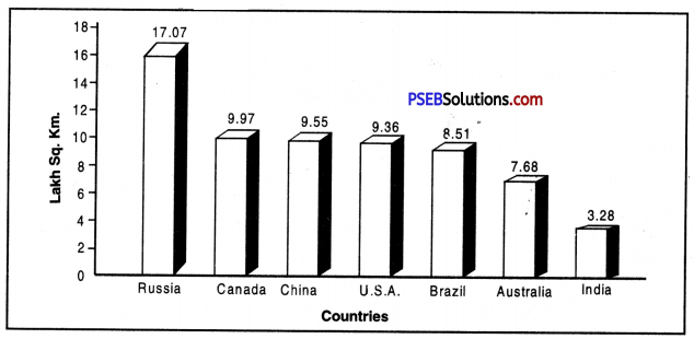
According to Census survey of 2011, India’s population was 1,21,05,69,5.73 means more than 121 crore. If we look at the expected data of 2016, it has reached upto 132 crores. Presently, the total population of the world is 742 crore. India’s geographical area is 32 Lakh 87 thousand sq. km. and India is at seventh place in the world. But India’s place is second from population’s aspect and around 17.2% people of the world live in India. It means every sixth person in the world is Indian.

Question 2.
The citizen of Punjab shall be on what rank, in terms of density of population, literacy rate and sex ratio.
Answer:

  1. Punjab is at 15th place from populations aspect and its population is 2,77,43,338.
  2. The Density of population in Punjab was 551 persons per sq. km. in 2011 which was 484 persons in 2001.
  3. Sex ratio in India was 1000 : 895 in 2011 which is actually quite less. Child sex ratio in Punjab was 1000 : 846 in 2011.
  4. Punjab’s literacy rate is 75.8% and it holds 15th place in India.

Question 3.
What are the main reasons of migration?
Answer:

  1. Migration in search of employment.
  2. Migration to find land for agriculture.
  3. Migration for religious freedom.
  4. Migration in the hope of more income.
  5. Migration due to some pressure or any other reason.
  6. People migrate for political freedom.
  7. Migration to do marriage.
  8. Rural people migrate to urban areas in search of better facilities.

PSEB 9th Class SST Solutions Geography Chapter 6 Population

Question 4.
How do we calculate literacy rate? How Punjab is behind many states in India in terms of literacy rate?
Answer:
According to Census of India, one who can* read and write in any Indian language is a literate person. In 1991, it was decided that children below the age of 7 years will be considered illiterate. This decision was followed even in 2Q01 and 2011 Census. There is a formula to know about literacy rate and this is :
Literacy Rate = \(\frac{\text { No. of Literate persons }}{\text { Total population }}\) × 100

If we look at Punjab’s position in terms of literacy rate then Punjab is at 14th place as its literacy rate is 75.8%. It is quite less in comparison to many other states such as Kerala (94%), Mizoram (91.3%), Goa (88.7%), Tripura (87.2%) etc.

Question 5.
Write a note on the distribution of rural-urban population in Punjab?
Answer:
Total population of Punjab is 2,77,43,338 out of which 1,03, 99,146 persons live in urban areas and 1,73,44,192 persons live in villages. In this way 37.5% people live in towns and 62.5% people live in villages. Urban population in 2001 was 33.9% which increased to 37.5% in 2011. Actually due to many factors, urban population is increasing such as more facilities, more opportunities of education and employment. During this period, there came great urbanisation in Sahibzada Ajit Singh Nagar district in which 54.8% people live in cities. In Taran Taran, only 12.7% live in urban areas and 87.3% people live in villages. So, we can say that gradually urban population is increasing.

Question 6.
Describe the National Population Policy 2000.
Answer:
While keeping in mind many objectives, Indian Government in 2000, made National Population Policy whose major aims are given below :

  • Compulsory and free education upto the age of 14 years.
  • To reduce the number of students who leave their education at primary and secondary level.
  • To reduce infant mortality rate upto 30 per 1000.
  • To reduce maternal mortality rate less than 100 per 1,00,000.
  • To give preference to small family.
  • To encourage girls to not to marry before the age of 18.
  • To give stress on delievering children from trained individuals.
  • To achieve the target of stable population till 2045.

Long Answer Questions :
Answer the following questions in detail :

Question 1.
What are the -specific problems adolescents may face?
Answer:
When a child crosses the age of 10 years, he enters the adolescent age. This age remains till 19 years. In this age, many physical and mental changes come in a child because of which he/she faces many problems which are given below :

  1. Child Marriage. This custom still prevails in many parts of the country and children with less than prescribed age group gets married. It reduces their physical and mental development. They are even unable to get proper education.
  2. Child Labour. A large portion of Indian population still lives below poverty line. That’s why children are forced to do any work to maintain their ‘house. They come under pressure in very early age to earn money when there is a time to take education.
  3. Drug Addiction. In this age, children very quickly adopt a wrong path and many children become drug addicts. Their future gets spoiled.
  4. Inadequate Diet. This is the age when children need good and healthy diet for proper physical and mental development. But due to poverty or any other reason, they are unable to get nutritious diet. It creates an obstacle in their allround development.
  5. Problem of Dropouts from Schools. This is the age when children take education and make their future. But it has been seen many parents withdraw their children from schools even before secondary level. They are forced to earn money which becomes a major problem for them.

PSEB 9th Class SST Solutions Geography Chapter 6 Population

Question 2.
Discuss situation of India and Punjab from migration point of view.
Answer:
Population of an area never remains the same. Birth rate and death rate plays an important role in increasing or decreasing population. But migration also plays an important role in this. But question arises that what is Migration? Actually the meaning of migration is when people leave one place to another place to live over there. This mobility or movement can be temporary as well as permanent
1. India’s Position. There is no denying the fact that many Indians migrate to foreign countries. North Indians prefer to migrate to the countries such as U.S.A., Canada, England, Australia, Germany etc. South Indians prefer to migrate to Gulf Countries. Actually everyone wants to earn more money and that’s why they migrate to western countries. The value of currency of western countries is much higher as compared to Indian currency. Consequently, Indians get attracted towards these countries. Doctors, Engineers, I.T. Professionals always try to migrate to earn more money. That’s why many Indians migrate each year to different countries.

2. Punjab’s Position. Like other Indians, Punjabi’s also prefer to mirgrate. A number of males of Jalandhar Doab region have already migrated to western countries and then they took their families with them. Their favourite destinations are Australia, U.S.A. Canada and England. They get attracted towards Dollars and leave no earth and stone to migrate from India.

If Punjabis are migrating to other countries then many people are also coming to Punjab. These are .those migrated labourers who come from the states like U.P. Bihar etc. to earn more money. They either work in industries or in agricultural fields. In 2011, around 21,30,262 people came to Punjab which become 8.7% of the total population of Punjab.

Question 3.
Describe the population density of India.
Answer:
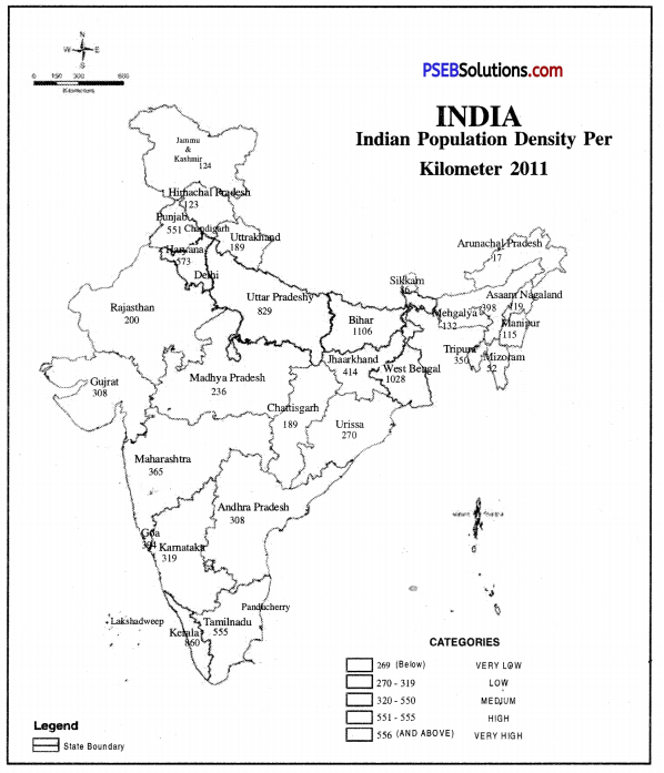
The distribution of population in India is very unequal. According to 2011 census the total population of India is 121 crores and the density of population is 382 persons per sq. kilometre. The density of population varies according to relief, climate and the agricultural productivity of the land. The density of population depends on the amount of rainfall. The areas of sufficient rainfall can support a large number of people.

1. Densely populated areas. These areas have a density of more than 400 persons per sq. kilometre. The high density areas makes a girdle round the Deccan plateau. Right from Satluj-Beas plain to Brahmaputra valley, the density of population is very high.
(а) West Coastal Plain. Kerala has 860 persons per sq. kilometre density of population.
(b) The East Coastal Plain. Tamil Nadu has a density of 555 persons per. sq. kilometre.
(c) The Northern Plain. It includes West Bengal (1028), Bihar (1106) , Uttar Pradesh (829), Punjab (551).
PSEB 9th Class SST Solutions Geography Chapter 6 Population 1

Factors favouring high density.

  • Sufficient rainfall
  • Fertile river valleys and deltas
  • 2 to 3 crops of rice in a year
  • Healthy climate
  • Rich in minerals and power resources.

2. Moderately populated areas. These include the areas with a density between 200 to 400 persons per sq. kilometre. These areas are surrounded by Eastern Ghats and Western Ghats. Haryana (573) Maharashtra (365), Andhra Pradesh (308), Karnataka (349), Gujarat (308), Orissa (270), Goa (394), Assam (398) have a moderate density.

Factors for moderate density.

  • Agriculture is not developed due to thin and rocky soils.
  • Rainfall is uncertain
  • Means of transportation are not developed.
  • Some areas have high density of population due to irrigation, lava soils and mineral resources.

3. Sparsely Populated Areas. These areas have a density less than 200 persons per sq. kilometre.
(a) North-Eastern India. This region includes Meghalaya (132), Manipur (115), Nagaland (119), Sikkim (86) and Arunachal (17).
(b) Rajasthan Desert. Rajasthan has a density of 200 persons per sq. kilometre.
(c) Western Himalayas. It includes Jammu and Kashmir (124), Himachal Pradesh (123).

PSEB 9th Class SST Solutions Geography Chapter 6 Population

Question 4.
Discuss Indian population from health and population fronts.
Answer:
1. Health. Health is considered as one of the important aspect of population structure which affects the development process of a country. Due to continuous government efforts, people’s health is continuely improving. In 1951, death rate was 25 per 1000 but in 201 h, it reduced to 7.9 per thousand. In the same way average age in 1951 was 36.7 years which also increased to 65.2 years in 2011.

This important change came due to many factors such as health of people, security from many diseases, using modern facilities etc. Government has opened up thousands of hospitals, dispensaries, health centres to provide better health services to the people. Even then health is a major cause of concern for us. Per capita calorie consumption is still quite less. A large portion of our population is still unable to get nutritious food. Clean drinking water and basic health facilities are still a distinct reality for large number of people. To remove such problems, a proper population policy is required.

2. Occupation. The percentage of working population in economy is an important indicator of development. Division of population on the basis of different occupations is called occupational structure. People are actually engaged in different occupations which are divided in three parts—primary, secondary and tertiary.
(а) Primary occupations. It includes agriculture, pastoralism, fishing, mining etc.
(b) Secondary occupations. It includes industries, construction etc.
(c) Tertiary occupations. It includes those people who give their services to the people such as administration, banking, insurance sectors etc.

The proportion of people engaged in different occupations is different in developed and developing countries. In developed countries, more people are engaged in secondary and tertiary sectors. But in developing countries, more people are engaged in primary sector. In India, 53% people are engaged in primary sector, 13% in secondary sector and 20% in tertiary sector. During recent times, this number has witnessed a continues change due to development of industrialization and urbanization.

PSEB 9th Class Social Science Guide Population Important Questions and Answers

Multiple Choice Questions :

Question 1.
India stands at___________place in the world from population point of view.
(a) Second
(b) Fourth
(c) Fifth
(d) Ninth.
Answer:
(a) Second.

Question 2.
How much of India’s population lives in Punjab?
(a) 1.3%
(b) 2.3%
(c) 3.2%
(d) 1.2%.
Answer:
(b) 2.3%.

Question 3.
How much of India’s population lives in rural areas?
(a) 70%
(b) 75%
(c) 78%
(d) 68%.
Answer:
(d) 68%.

PSEB 9th Class SST Solutions Geography Chapter 6 Population

Question 4.
Punjab’s densities of population in 2011 was
(a) 888
(b) 944
(c) 551
(d) 933.
Answer:
(c) 551.

Question 5.
In 2011, how many females were there behind every 1000 males?
(a) 943
(b) 933
(c) 939
(d) 894.
Answer:
(a) 943.

Question 6.
Which Indian state has highest density of population?
(a) Uttar Pradesh
(b) Bihar
(c) Rajasthan
(d) Tamil Nadu.
Answer:
(b) Bihar.

Question 7.
Which Indian state has least density of population?
(a) Mizoram
(b) Sikkim
(c) Arunachal Pradesh
(d) Nagaland.
Answer:
(c) Arunachal Pradesh.

Question 8.
What was sex ratio of Punjab in 2011?
(a) 943
(b) 866
(c) 872
(d) 895.
Answer:
(d) 895.

Question 9.
Which Indian district has highest population?
(a) Thane
(b) Uttar Chaubis Pargana
(c) Dibang Ghati
(d) Anjah.
Answer:
(a) Thane.

PSEB 9th Class SST Solutions Geography Chapter 6 Population

Question 10.
Which of these is the reason of migration?
(a) Search of employment
(b) Religious Freedom
(c) Political Freedom
(d) All of these.
Answer:
(d) All of these.

Fill in the blanks :

Question 1.
In 2011, India’s total urban population was ___________
Answer:
35 crore

Question 2.
In rural areas, the percentage of labourers is _________
Answer:
40%

Question 3.
In 2011, India’s density of population was _________ persons per sq.km.
Answer:
382

Question 4.
The percentage of labourers in India is _________
Answer:
37.50

Question 5.
_________ state has maximum percentage of labourers.
Answer:
Andhra Pradesh

Question 6.
The population in the age group of 15-65 years is
Answer:
58.4.

True/False :

Question 1.
India holds first place in the world from population point of view.
Answer:
False

PSEB 9th Class SST Solutions Geography Chapter 6 Population

Question 2.
Population in mountainous and desert regions is quite dense.
Answer:
False

Question 3.
In poor countries, more population comes in the age group of 10-14 years.
Answer:
True.

Question 4.
India’s sex ratio is quite less.
Answer:
True.

Question 5.
Natural growth in population depends upon the difference in birth rate and death rate.
Answer:
True.

Very Short Answer Type Questions

Question 1.
What is meant by Density of Population?
Answer:
An average number of people living in square kilometres is known as density of population.

Question 2.
Which is the major factor affecting population distribution in India?
Answer:
Agricultural productivity.

Question 3.
Name any two parts of India with a dense populations.
Answer:
Upper Ganga Valley and Malabar region.

Question 4.
Which areas of India has less density of population?
Answer:
North-eastern states, western Rajasthan, few parts of Gujarat etc.

PSEB 9th Class SST Solutions Geography Chapter 6 Population

Question 5.
What are the adverse consequences of increasing population in urban areas?
Answer:
Pressure on available resources and public facilities.

Question 6.
What is meant by sex ratio?
Answer:
Number of females after every 1000 males in any area is called sex-ratio.

Question 7.
What is meant by working population?
Answer:
Working population is that population which is engaged in different occupation to earn money.

Question 8.
What is dependent population?
Answer:
All those children and old age persons come in dependent population who cannot earn and are dependent on working population.

Question 9.
Give reason of decreasing death rate.
Answer:
The spread of health services by the government.

Question 10.
Name the Indian state with least population.
Answer:
Sikkim.

Question 11.
What is the density of population in India?
Answer:
382 persons per sq.km.

PSEB 9th Class SST Solutions Geography Chapter 6 Population

Question 12.
What is the density of population in West Bengal?
Answer:
1028 persons per sq.km.

Question 13.
Which state has highest density of population?
Answer:
Bihar.

Question 14.
Which state has highest population in India?
Answer:
Uttar Pradesh.

Question 15.
What is density of population in Delhi?
Answer:
11297 persons per sq.km.

Question 16.
What was sex ratio in India in 2011?
Answer:
943 persons after every 1000 males.

Question 17.
Which state in India has highest literacy rate?
Answer:
Kerala.

Question 18.
Which state has lowest density of population?
Answer:
Arunachal Pradesh.

PSEB 9th Class SST Solutions Geography Chapter 6 Population

Question 19.
What is the most important and valuable resource of a country?
Answer:
The people of the country healthy, mentally as well as physically is the biggest natural source of a country.

Question 20.
What were the causes of slow increase in population before independence?
Answer:
The causes of this normal growth are epidemics, wars and famines which increase death rate.

Question 21.
What was the population of India in the year 1901?
Answer:
The population of India was 23,83,96,327 (23.8 Crore) in the year 1901.

Question 22.
What is the population of India in the year 2011?
Answer:
The population of India was 121 crores in the year 2011.

Question 23.
What is rank of India in the world from the point of view of populations?
Answer:
India ranks second in world (after China) in the view of population.

Question 24.
Write the name of the states with highest and lowest population.
Answer:
Uttar Pradesh has the highest population (19.9 crore) and Sikkim has the lowest population to (6 lakh) in India.

PSEB 9th Class SST Solutions Geography Chapter 6 Population

Question 25.
Name the states which have a population of more than 5 crores.
Answer:
There are 10 states of India in which population is more than 5 crores.

Question 26.
What was the population of Punjab in the year 2011 and what is the rank of Punjab from the population point of view?
Answer:
The population of Punjab was 2.77 crores in the year of 2011 and Punjab ranks 15th in the country in the view of population.

Question 27.
What percentage of population of India lives in Punjab?
Answer:
Almost 2.3 percent of total population of country live in Punjab.

Question 28.
How many cities are there in India with a population of more than one lakh?
Answer:
There are 302 cities in India with the population of more than one lakh.

Question 29.
How much per cent of population of our country live in plains?
Answer:
40% of population of the country lives on the plains.

Question 30.
How much percentage of population of the country lives in villages?
Answer:
More than 68% of population of the country lives in the villages.

Question 31.
What is the average density of population in our country?
Answer:
The average density of population in India is 382 persons per square kilometres.

PSEB 9th Class SST Solutions Geography Chapter 6 Population

Question 32.
Name the states having highest and lowest density of population.
Answer:
Bihar is the state with highest density of population (1102) and Arunachal Pradesh is the state with lowest density of population (17) in India.

Question 33.
What is the density of population in Punjab?
Answer:
The density of population is 551 persons per square kilometre in Punjab. Question 34. Which union territory has the highest.density of population? Answer:National Capital Area Delhi has the largest density of population (11297).

Question 35.
Name the elements that determine the age structure.
Answer:
The factors which determine the age structure are :

  • Fertility
  • Mortality
  • Migration.

Question 36.
What is percentage of population that fall in the 0-14 years age group in our country?
Answer:
37.2% of population is found in the country with the age of 0-14 years.

Question 37.
What percentage of population falls in the 15-64 years age group in our country?
Answer:
58.4% of population is found in the country with the age group of 15-65 years.

Question 38.
What do you understand by sex ratio?
Or
What is meant by sex ratio?
Answer:
The number of women per thousand men is sex ratio.

Question 39.
What is sex ratio of the population of the year 2011?
Answer:
The sex ratio is 943 females for 1000 males in India according to 2001 census.

Question 40.
What are the rural and urban sex ratio?
Answer:
The sex ratio is 939 in rural areas and is 894 per thousand men in urban areas in the year of 2011.

PSEB 9th Class SST Solutions Geography Chapter 6 Population

Question 41.
Give two reasons decreasing sex ratio in India.
Answer:
Female foeticide and lower status of females in India.

Question 42.
What is birth rate?
Answer:
Number of births behind every 1000 persons in a particular area is called birth rate.

Question 43.
What is death rate?
Answer:
Number of deaths behind every 1000 persons in a particular area is called birth rate.

Question 44.
What is migration?
Answer:
When a person leaves his geographical area moves to other area to live is called migration.

Question 45.
What is adolescent age?
Answer:
Age between 10-19 years is called adolescent age.

Question 46.
Give one problem of adolescent age.
Answer:
Many physical changes come in this age and children feel quite awkward.

Question 47.
Why migrant labourers come to India?
Answer:
To earn money by working in industries and in agricultural fields.

Question 48.
From which states did migrant labourers come to Punjab?
Answer:
Uttar Pradesh, Bihar, Jharkhand, West Bengal etc.

Question 49.
Which district of India have highest and lowest population?
Answer:
Highest Population: Thane (Maharashtra)- 1,10,60,148 persons.
Lowest Population: Dibang Ghati (Arunachal Pradesh)-8004 persons.

Question 50.
What is literacy rate in India?
Answer:
In 2011, literacy rate in India was 74.04%.

Question 51.
Which district of Punjab has highest sex ratio?
Answer:
Hoshiarpur-1000: 961.

PSEB 9th Class SST Solutions Geography Chapter 6 Population

Question 52.
Which district of Punjab has highest literacy rate?
Answer:
Hoshiarpur-84.16%.

Short Answer Type Questions

Question 1.
What do you mean by Census Survey? Write a note on it.
Answer:
Indian government conducts counting of population after every ten years which is called census survey. In this, information is collected about the age, sex, house, literacy rate etc. First census in India was held in 1872 and after this, census is held in the first year of each decade. The census of 2011 was 15th census survey in which? 2200 crore were spent and 27 lakh officer conducted this survey.

Question 2.
What is the difference between Regional distribution of Population and density of population?
Answer:
Distribution of population refers to a place or area, but density of population refers to a ratio. Distribution reflects a pattern of population. It shows Whether population is scattered or concentrated at a place. But density of population shows size of population ratio between men and land.

Question 3.
What are the factors that affect the distribution of population?
Answer:
Population in India is not evenly distributed many factors are responsible for this.

  1. Fertility of the soil. The states in which there is a large fertile area the density of population is high. U.P. and Bihar are such states.
  2. Amount of rainfall. The density of population is higher in regions of abundant rain. In northern India the amount of rainfall goes on decreasing from east to west. The density of population also goes on decreasing in the same direction.
  3. Climate. Wherever the climate is congenial the density of population will be high. In Assam even though there is abundant rainfall but the density of population is low because the climate is unhealthy. The malaria is always there is an epidemic form.
  4. Developed means of transportation. With the development of means of transportation the business makes rapid progress and the density of population increases. The reason for high density of population in U.P., Bihar and West Bengal is the development of means of transportation.

Question 4.
Why is India known as country of villages?
Answer:
There is no doubt that India is a country of-villages.

  • Most of people live in villages.
  • 3/4th of population lives in rural areas.
  • There are more than 5 lakh and 50 thousand rural settlements but 71% of urban population lives in 302 towns.
  • About 40.1% of labourers live in rural areas and 30.2% of labourers live in urban areas.

PSEB 9th Class SST Solutions Geography Chapter 6 Population

Question 5.
What are characterisitc features of regional distribution of population?
Answer:
Characteristics :
1. The distribution of population is uneven in India. There is dense population in river valleys and coastal plains. There is space population in hilly, deserts areas and drought affected areas, 16% of the area of the country, in the Northern plains only 3% people of India live. 94% of population lives on an area of 18% in plains. Only 2% population lives on an areas of 6% in Rajasthan.

2. Most of the people live in villages. Only 31% people live in urban areas.

3. A large part of minorities live in sensitive border area. Along the N.W. border of India. Sikhs in Punjab and Muslims in J & K. form a majority community. Along the borders of China and Burma, in the North East, mostly Christians are found. It has created many political economic and social problems.

4. On the one hand, there is concentration of population in river valleys and coastal areas but deserts, hilly areas are sparsely populated. It looks like a demographic divide.

Question 6.
What do you mean by density of population? Tell something about density of population in India.
Answer:
Persons living in a square kilometre is called density of population. How many persons live in a particular area, will be known only by looking at density of population. According to Census survey of 2011, population density in India was 382 persons per sq.km. There are many Indian states where density of population is quite high such as Bihar (1106), West Bengal (1028), Kerala (860), Uttar Pradesh (829), Punjab (551) etc. But there are few states in which there is quite less density of population such as Nagaland (119), Sikkim (86), Mizoram (52), Arunachal Pradesh (17) etc. Delhi’s density of population is 11297 which is highest among all the union Territories.

Question 7.
Write a note on population Growth.
Answer:
Population of a place or a country never remains the same but it changes from time to time. That’s why when positive changes come at a particular place on a particular time, it is called population growth. This population growth can be due to many reasons such as birth rate, death rate, migration of people etc. The population growth of India between 2001 to 2011 was 17.68% and that of Punjab was 13.9%. Population growth can be calculated with a formula :
Population Growth = \(\frac{\text { Pure growth in Ten Years }}{\text { Total population }}\) × 100

Question 8.
Name few factors responsible for population growth.
Answer:
Many factors are responsible for population growth such as:

  • If birth rate is more than death rate then population increases.
  • If girls get married at an early age then there is a possibility of population growth.
  • If climate is positive for life then also there will be an increase in population.
  • Universality of marriage is also responsible for population growth.

Question 9.
Write a note on Age composition.
Answer:
The process of dividing population of a place, state or country in different age groups is called age composition. Generally, whole of the population is divided in three groups. In first group, people with the age of 0-14 years are included. In the second group, people with the age of 15-84 years are included which is known as working class. Third group includes people with the age of 65 years or above which is known as dependent group. First and third group are dependent upon second group for their needs. Dependency ratio can be expresses with a formula :
Dependency Ratio = \(\frac{\text { No. of children }+\text { No. of old Age people }}{\text { No. of Adults }}\) × 100

Question 10.
What is sex-ratio? Explain sex ratio in India.
Answer:
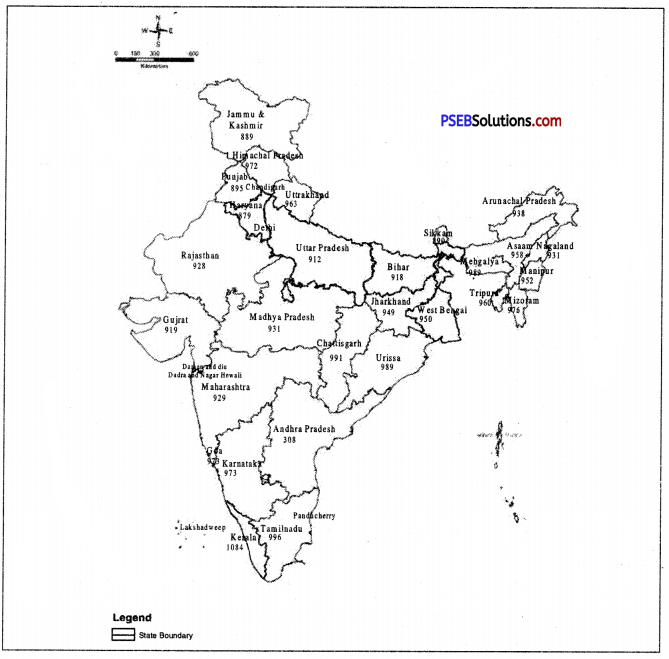
Number of females behind 1000 males in a particular area is known as sex ratio. In 2011, sex ratio in India was 1000 : 943 means there were 943 females behind every 1000 males. Sex ratio in India was always low. Only Kerala (1084) and Puducherry (1037) has positive sex ratio but it is negative in other states. In Punjab (895) and Haryana (879), it was quite less. If we want to know about the status of women in any society, we must look in for sex ratio of that place. But during last few decades, it is continuely improving due to official efforts.

Question 11.
What are the causes of low sex Ratio in India?
Answer:
The sex ratio of India is 943 per thousand males. There is a general declining trend in sex ratio. The ratio in 1901 was 972. It was declined to 934 in 1981. This decline has been due to social evils in our society.

In our society, female child is neglected. Male population dominates in our society. There is high death rate among females. Death rate is particularly high among married women. Women labour migrates to some mining and industrial centres. It also results in declining sex ratio.

PSEB 9th Class SST Solutions Geography Chapter 6 Population

Question 12.
What is the Sex ratio of States of North India?
Answer:
There is an adverse sex ratio in Northern India. The number of females is less than that of males. It is clear from sex ratio in Bihar (916), Rajasthan (926), Punjab (895), U.P. (898), and Haryana (877). (The lowest Sex Ratio in India).

Question 13.
What is the importance of Economic Structure of population?
Answer:
Importance

  1. We come to know the percentage of people engaged in productive \york.
  2. It shows the cultural composition of population which determines the stage of development of a country.
  3. It marks the backward areas of the country so that proper planning can be done.

Question 14.
Why is it necessary to study the structure of population?
Answer:
It is necessary to study the structure of the population of a country due to :
1. We need different components of population such as age structure, sex ratio, occupational structure for the economic and social planning of a country.

2. The different aspects of population have a close relationship with developoment on the one hand. These are affected by population and on the other hand these affect population and development. For example, if the percentage of children and old age people is high in age structure, a country has to spend more on education and health facilities. On the other hand, a high percentage of working age group encourages the economic development of a country.

Question 15.
What are the importance of study of age structure?
Answer:
These are the advantages of study of age structure of population :
1. By determining the 0-14 age group the govt, knows that there is need of expenditure on education, health and social services. So new schools, health centres and community centres are opened.

2. We know the number of eligible voters in the country which is vital for a democracy. There should be 58% voters per age group, but actually there are 60% of voters in the country.

Question 16.
Write about the needs of adolescents in adolescent age.
Answer:

  • Adolescents must get good and balanced diet.
  • They must be given proper environment and proper education.
  • They must be informed about physical changes.
  • Parents and society must talk with them with great love and affection.
  • Efforts must be made to save them from drug addiction.
  • They must be provided with proper guidance for a good future.

Question 17.
What is the role of society, teachers and parents in making future of adolescents?
Answer:

  • Parents can provide good education and environment to their children to give them a bright future.
  • Parents can show them the way to make their children better citizens, to remain away drugs etc.
  • Teachers can motivate their students to become good citizens by giving them proper education.
  • Social, Religious and Political leaders can motivate their students to move on a right path.

PSEB 9th Class SST Solutions Geography Chapter 6 Population

Question 18.
Write a note on gender based structure of Punjab.
Answer:
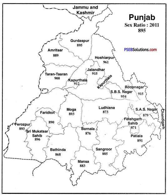
Punjab’s total population is 2,77,43,338 out of which 1,46,39,465 are males and 1,310,3873 are females. Their sex ratio is 1000 : 895. It means that after every 1000 males, there are 895 females which is quite less. This is 875 in cities and 907 in village which is little bit more in comparison to 2001. Sex ratio of Hoshiarpur district (961) is at the top and then it comes Shaheed Bhagat Singh Nagar (954)), Jalandhar (915) and Roop Nagar (915). Bathinda (868) has the lowest sex ratio. Then it comes the number of Fathegarh Sahib (871). During last decade, this sex ratio has increased due to strict official efforts.
PSEB 9th Class SST Solutions Geography Chapter 6 Population 2

Question 19.
Throw a light on the occupational structure in Punjab.
Answer:
Agriculture is the major occupation of the people of Punjab and that’s why most of the population is engaged in agriculture or related acitvities. Out of total workers of Punjab, 35.5% are engaged in agriculture or related activities 3.9% people are engaged in household industries. Rest of the 60.5% people are engaged in other activities. In the districts of Sri Muktsar Sahib and Mansa, most of the workers are engaged in agriculture but in Ludhiana and Sahibzada Ajit Singh Nagar, very few people are engaged in agriculture but rest are busy in industrial and service sector. A number of Punjabi’s have migrated to other countries in search of employment.

Question 20.
Give cause of Declining Sex Ratio.
Answer:

  1. People want to have a boy child and they never hesitate to abort the female foetus. It leads to decline in sex ratio.
  2. Sex ratio declines with increase in female foeticide.
  3. Sex ratio declines with the custom of killing new born girls i.e. female infanticide.
  4. Emigration of males from one place to another also leads to decline in sex ratio.
  5. In traditional societies birth of girl is considered as a curse because of which boys are preferred over girls. It also leads to decline in sex ratio.

Question 21.
Give consequences of Declining Sex Ratio.
Answer:

  • Declining Sex ratio leads to increase in violence against women.
  • The custom of polyandry encouragement with declining sex ratio.
  • Declining sex ratio leads to lower social status of women.
  • Health of women deteriorates with it.
  • Trade of women also takes place with declining sex ratio.

Question 22.
Which are the states those have high density of population?
Answer:
There is dense population in Northern plains, western coastal plain, Eastern Coastal plain (Deltas). These area have fertile soils and facilities of irrigation. So the population is dense. As we go westward, the rainfall goes on decreasing and the density of population also decreases. That is why the density of population in West Bengal is greater than that in Haryana and Punjab. Kerala has also high density because two or three crops can be grown due to high rainfall.

Question 23.
What are the causes of high density of population in plains?
Answer:
The density of population is high in plains. This is due to :

  • The Northern plain is fertile.
  • It has high rainfall.
  • It has many big industrial centres.
  • The means of transport are developed.
  • Coastal plain has the facilities of fishing and foreign trade.

Question 24.
What are the areas of low density of population?
Answer:
Thar Desert, Eastern Himalayas and Chotta Nagpur plateau are sparsely populated areas.

  • The soils are infertile or sandy or stony.
  • The means of transport are not developed.
  • The climates is not healthy. It is either too hot or too cold. Himalayas get heavy rainfall.
  • Industries are not developed in these areas except Chotta Nagpur plateau.

Long Answer Type Questions

Question 1.
Explain in detail the state wise structure of sex ratio in India.
Answer:
Sex ratio means the number of females per 1000 males. Now a days, women have equal rights with men. In developed countries, the number of women is equal to number of men. In some countries sex ratio is 1050. The average sex ratio in developing countries is 964. In India, in 2011, sex ratio was 940, and is one of the lowest in the world.

State-wise sex ratio. Sex ratio is not uniform in all states. Only one state, Kerala, has sex ratio of 1084 and Puducherry (1036) (Above the average). In other states, sex ratio is less than average.
PSEB 9th Class SST Solutions Geography Chapter 6 Population 3
It is clear that Northern States have low sex ratio and it is a matter of concern.
PSEB 9th Class SST Solutions Geography Chapter 6 Population 4

Question 2.
List factors influencing distribution of population.
Answer:
The following factors influence the distribution of population :
1. Fertility of the soil. The states in which there is a large fertile area, the density of population is high. U.P. and Bihar are such states.

2. Amount of rainfall. The density of population is higher in regions of abundant rain. In northern India, the amount of rainfall goes on decreasing from east to west. The density of population also goes on decreasing in the same direction.

3. Climate. Wherever the climate is congenial, the density of population will be high, In Assam even though there is abundant rainfall but the density of population is low because the climate is unhealthy. The malaria is always in an epidemic form.

4. Developed means of transportation. With development of means of transportation the business makes rapid progress and the density of population increases. The reason for high density of population in U.P., Bihar and West Bengal is the development of means of transportation.

5. Industrial development. At places where the factories are located, the density of population also increases. The reason is that people like to live in those areas where industrial development takes place. They can carry on their business more easily in such areas, and they have better chances of earning more money. That is why the density of population is high in Delhi, Mumbai and Kolkata.

PSEB 9th Class SST Solutions Geography Chapter 6 Population

Question 3.
Write an essay on problem of population increase in India and also enlighten the solution to this problem.
Answer:
India’s population is growing rapidly, and creating some problems.
1. Low standard of living. Indian people have low standard of living as compared that of Europeans. About 48% people live below poverty line. They do not have full meals. It results in low production capacity.

2. Deforestation. The forests are cleared rocklessly to meet the growing needs. It has resulted in problems of soil erosion floods, pollution and loss of forest- wealth.

3. Lack of pastures. India has only 4% land under pastures. If this land is used for other purposes, it will result in shortage of fodder for cattles.

4. Pressure on population. Land is a limited source and cannot be increased. It is leading a pressure of population on land. It will decrease the productivity of the land.

5. Lack of minerals. Industries are developed to meet the growing needs of people. So more minerals are used. These reserves will exhaust soon.

6. Environment. Population growth has an adverse effect on environment. Clear water and air is a problem. Oxygen is also decreasing.

Solutions:

  • Family planning should be adopted,
  • People should be explained the significance of small families by films, songs, plays,
  • Illiteracy should be abolished so that people should understand harms of growing population.
  • Female education should be increased, marriageable age of girls be increased.

Question 4.
Write a note on population distribution in Punjab.
Answer:
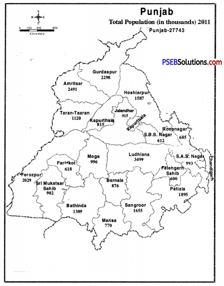
Punjab’s total population is 2,77,43,338 and this population lives in 12,581 villages and 217 big small cities. Few areas of Punjab has more concentration of population and few areas have less concentration. Cities like Ludhiana and Amritsar have more population i.e. 16 Lakhs and 11 Lakhs respectively. But the population of few cities is in thousands. On the basis of population density Punjab can be divided in four parts and these are :
PSEB 9th Class SST Solutions Geography Chapter 6 Population 5
1. Areas with less density of population. In first category, those districts are included where population density is less than 400 persons per square kilometre. Sri Muktsar Sahib is included in this category whose population density is 348 which is quite less than other districts.

2. Moderate density of population. Those districts are included in this category which has a population density of 401-500 persons per sq. km. It includes many districts such as Taran Taran, Hoshiarpur, Faridkot, Shaheed Bhagat Singh Nagar, Moga, Faridkot, Barnala, Bathinda, Sangrur, etc.

3. More density of population. The third category includes the districts of Patiala, Fatehgarh Sahib, and Roop Nagar where the density of population is between 501-600 persons per sq. km.

4. Extreme Density of population. It includes such districts whose density of population is more than 600 persons per sq. km. The districts of Amritsar, Gurdaspur, Ludhiana, Jalandhar, Sahibzada Ajit Singh Nagar are included in this category. Ludhiana’s density of population is 978 which is the highest in Punjab. Then comes the number of Amritsar (928) Sahibzada Ajit Singh Nagar (909) and Jalandhar (836).
PSEB 9th Class SST Solutions Geography Source Based Questions and Answers

Punjab State Board PSEB 9th Class Social Science Book Solutions Geography Source Based Questions and Answers.

PSEB Solutions for Class 9 Social Science Geography Source Based Questions and Answers

Question 1.
Read the following quotes carefully and answer the given questions : The Indian Republic is a large country with a large geographical spread. India is a distinct geographical unit, in which a distinct culture has developed. It is the seventh largest country in the world. Where as in terms of population, it ranks second in the world after China. It is clear from this that 17.5% (2011 data) population is on 2.4% of the total geographical area of the world. On the northern border of China, there are mountain ranges of the Great Himalayas which extend parallel to each other. She makes India a separate territory from Asia. The vast fertile plains of the Ganges and Brahmaputra rivers provide food security to our country. The peninsular plateau is a storehouse of natural minerals. Surrounded by many major rivers, lakes and vast oceans on all three sides of the world, India holds the status of an independent landform or subcontinent.
(A) What is the place in the world in terms of area and population of India?
Answer:
India ranks seventh in the world in terms of area. In terms of population, India is second.

(B) Why is India called the sub-continent?
Answer:
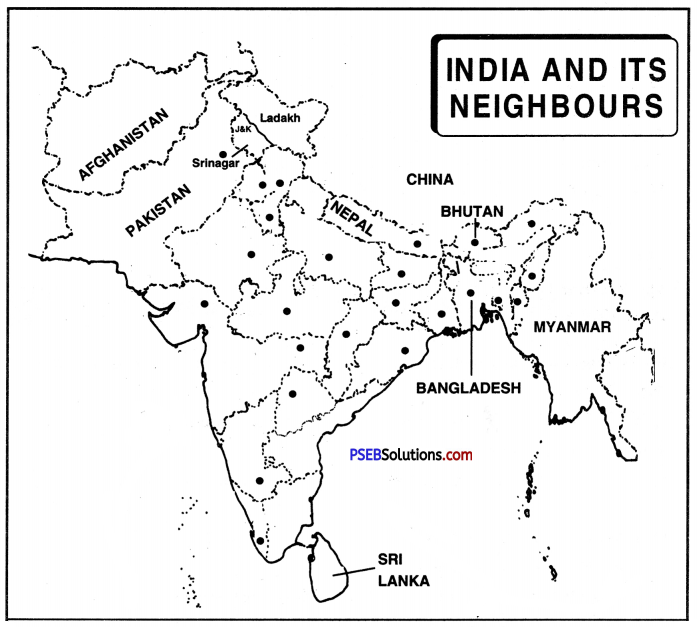
India is located to the South of the continent of Asia. Part of Asia is a distinct geographical entity. It is separated from the rest of Asia by the Himalayan mountains. India has been given the status of a sub-continent due to its’ features. The Indian sub-continent consists of countries other than India including Pakistan, Nepal, Bhutan, Bangladesh, Sri Lanka, Maldives etc.

Question 2.
Plains of Punjab-Haryana-These plains are spread over an area of about 640 Kilometres from northwest to south-east. Their average width is up to 300 km. The total area of this ground is up to 1.75 lakh km. This plain is made up of alluvial deposits of Indus and its tributaries: Sutlej, Beas and Ravi. There are five Doabs of this ground, including Bist Doab (Beas and Sutlej), Bari Doab (Beas and Ravi), Rachna Doab (Ravi and Chenab), Chaj Doaba (Chenab and Jehlum) and Sindh-Sagar Doab (Jehlum, Chenab and Sindhu (middle) area of the river).
(A) Write about the extension of the plain of Punjab-Haryana?
Answer:
The plain of Punjab-Haryana has spread about 640 km from North-West to South-East. Its average width is 300 km. Its total area is 1.75 lakh square kilometres.

(B) How did these plains become? Write the names of its doabs.
Answer:
This plain is formed by the accumulation of alluvium of Indus and its tributaries; Sutlej, Beas and Ravi. There are five Doabs of this plain, Bist Doab (Beas and Sutlej), Bari Doab (Beas and Ravi), Rachna Doab (Ravi and Chenab), Chaj Doab (Chenab and Jehlum) and Sindh-Sagar Doab (Jehlum, Chenab and Indus River of middle area.)

PSEB 9th Class SST Solutions Geography Source Based Questions and Answers

Question 3.
The plains of the Indus, Ganga and Brahmaputra rivers are one of the largest plains in the world. These plains are about 2,400 km long and 150 to 130 km wide. These plains are made of alluvial soil. In millions of years, this fertile plain has been created due to the deposition of alluvium in a very large basin situated in Giripad, Himachal. Many plains are also built-in these plains such as Alluvial fans, alluvial cone, crooked or meandering rivers, natural leaves, flood plains etc. Most of the Terai Region of Punjab, Uttarakhand has been cut into forests and made into arable land.
(A) How was India’s vast northern plains formed?
Answer:
The vast plains of India have been formed by the deposition of alluvial soil brought by the Indus, Ganga and Brahmaputra rivers. These deposits occurred in a huge basin in Girpad in the Himalayas.

(B) Name the main landforms of these plains.
Answer:
Many landscapes are found in these plains, like alluvial fans, alluvial cone, meanders, crooked or erosive flow, rivers, natural leaves, flood plains etc. Most of the Terai Region of Punjab, Uttarakhand has been cut into forests and made into arable land.

Question 4.
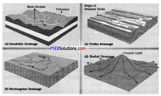
A network of rivers and canals flowing in an area is called water flow. Nature has given India hundreds of big and small rivers. It is very important for students to understand some facts related to water flow, such as Doab, water separator and drainage pattern etc. The area between the two rivers is called Doab. Any elevated area, such as a mountain or high land that divides two water streams, is called a water divide. The water flowing over any part of the earth creates many different forms which are called drainage forms.
(A) What is the meaning of water flow?
Answer:
The network of rivers and canals flowing in an area is called water flow. This means that the network of all the rivers or canals flowing in a particular area is called water flow.

(B) Who is called Doab?
Answer:
The area between two rivers is called Doab. This means that the area or plain between two rivers is called Doab.

(C) Explain the meaning of water divide.
Answer:
The elevated area, such as a mountain or a high land that divides two water streams is called a water divide.

Question 5.
Rivers have been of great importance throughout human history. The Indus Valley civilization is an example of this. Water has attracted humans since ancient times. Our life depends on water only. The survival or absence of population is dependent on water. Folk songs, stories, folk-dances, agriculture are all dependent on water. Water is the most important natural resource. For livelihood, water is very important everywhere in agriculture, irrigation, hydroelectric construction, industiral area, construction and homes. Internal water ways are possible only due to rivers.
(A) What is the importance of rivers in our life?
Answer:

  • Rivers give us drinking water. This water is purified to make it potable.
  • Many multipurpose projects are put on these rivers which not only provide electricity but also provide water for irrigation.
  • Many civilizations flourish on the banks of these rivers. Indus valley civilization is an example of this.
  • Rivers bring alluvial soil from the mountains in which our plains become fertile.

(B) What is an internal waterway?
Answer:
Many rivers flow in India and many of these rivers go and merge in some sea. But there are some rivers that cannot reach the sea and dissolve on the way. All these are called internal waterways.

PSEB 9th Class SST Solutions Geography Source Based Questions and Answers

Question 6.
Human life is greatly influenced by climate. Man is completely subject to climate at every stage of life, including food, clothes, design of homes, health work, employment etc. In cold climate regions, hot things are used in food such as tea, coffee and hot food. Colder substances like lassi, ice, sorket etc. are used more, in countries with hot climate. Warm clothes such as coats, sweaters (Woollen garments), jackets, blankets etc. are used in cold countries. Homes are open and ventilated in areas with hot climates. The roofs of houses in hilly areas are sloping. Fruits like apples, almonds, cherries in cold winter. Climate and crops of sugarcane, cotton, rice, jute etc. are grown in hot climatic regions.
(A) How is human life affected by climate?
Answer:
Human life is greatly influenced by climate such as:

  • Our food habits are affected by climate such as hot things are eaten in cold areas,
  • Our clothes are also affected by climate such as wearing warm clothes in cold areas,
  • The structure and size of our houses are also affected by climate such that houses in hot areas are open and ventilated,
  • People living in cold and mountainous areas are physically stronger.

(B) Which crops grow in cold and hot climate areas?
Answer:

  • Fruits like apple, almond, cherry are grown in cold climate areas.
  • Crops like cotton, sugarcane, rice, wheat, jute etc. are grown in areas with hot climate.

Question 7.
Natural vegetation is a boon for humans or for the provincial economy. There is an acute need for its protection and development. We are aware that the situation of Punjab in this region is not favourable as only 6.07 percent of the forests are found here. The other part of the ground is being used’for the development of agriculture, industry, roads and railways, villages and cities. In terms of population, the area of Punjab is much less than the average of the country. The state’s population and pollution rate are constantly increasing. Therefore, there is a great need to increase the area under vegetation. To accomplish this goal, more and more trees should not be planted in the arable land.
(A) What is the benefit of natural vegetation to us?
Answer:

  • We get oxygen from natural vegetation which gives us clean air.
  • We get many types of wood from natural vegetation which makes our furniture.
  • Many types of herbs are found from natural vegetation which are used in making many types of medicines.
  • There is no land degradation due to natural vegetation.

(B) Why should we increase the area of natural vegetation?
Answer:

  • We should increase natural vegetation to increase fresh air.
  • It is necessary to increase the forests to meet its wood requirements.
  • It is necessary to increase the area of natural vegetation to save land degradation.
  • To give good life to the coming generations, natural vegetation needs to be more and more.

PSEB 9th Class SST Solutions Geography Source Based Questions and Answers

Question 8.
If we want to live our life comfortably and think the same for future generations then we should protect our forests properly. Planting of plants is called afforestation. We can plant saplings or barren land or non-agricultural land without converting them into forests. You can improve the deteriorating state of forests by planting 311 social forests, agricultural forests, commercial forests. The government should make every effort to awaken the people regarding the importance of forests and cooperation for their protection. Laws should be strictly enforced by the Forest Department and punish the culprits for cutting down trees, either illegally or without adopting the right method.
(A) What are the benefits of forests?
Answer:

  • Forests control the climate compact, forests prevent temperature rise in summer and increase the temperature in winter.
  • The roots of dense forests help in reducing the speed of flowing water, thus reducing the speed of flowing water, thus reducing the outbreak of floods.
  • The roots of trees strengthen the soil tightness and prevent soil erosion.
  • The soil gets green manure in the form of bacteria due to dry leaves falling.

(B) How can we save the dwindling forests?
Answer:

  • We can imporove the deteriorating state of forests continuously by dividing forests into different parts.
  • People should be awakened from time to time for the benefits and care of the forests.
  • Cutting of forests should be declared as a legal offence and strict punishment should be given to those who cut down trees without proper law.
  • People should be constantly encouraged to plant new trees.

Question 9.
In our country, the girl is worshipped on one side and on the other side, she tries to take away her right to live. But now the time has come when we have to get rid of the priority of men and children have to understand the gift of nature without any gender discrimination. In future, we can not imagine a society without women. Misconceptions about women need to be changed. By punishing the guilty, the law has to be strictly enforced. We must end shameful and illegal acts such as female feticide and forced abortions.
(A) What is the meaning of female feticide?
Answer:
When it is found out about a pregnant woman that she is having a daughter in her womb, she is killed in the womb or the woman is miscarried. This process is called female feticide.

(B) Why female feticide is done?
Answer:

  • Dowry has to be given at the time of marriage of the girl. That’s why people don’t want girls. So they commit female feticide.
  • It is written in religious texts that to attain liberation one must have a boy. So they kill the female fetus.
  • Use of modern techniques has promoted female feticide.
  • People also commit female feticide in order to gain respect in society.

PSEB 9th Class SST Solutions Geography Chapter 5 Natural Vegetation and Wild Life

Punjab State Board PSEB 9th Class Social Science Book Solutions Geography Chapter 5 Natural Vegetation and Wild Life Textbook Exercise Questions and Answers.

PSEB Solutions for Class 9 Social Science Geography Chapter 5 Natural Vegetation and Wild Life

SST Guide for Class 9 PSEB Natural Vegetation and Wild Life Textbook Questions and Answers

Map Work

Question 1.
Show in the outline map of India:
(i) Any three regions of different types of natural vegetation.
(ii) National parks situated in any five states.
(iii) Water reserves of Punjab (in an outline map of Punjab).
Answer:
Do it yourself with the help of India Map.

Question 2.
Identify the trees shown below and specify the type of vegetation.
PSEB 9th Class SST Solutions Geography Chapter 5 Natural Vegetation and Wild Life 1
Answer:
Do it yourself.

PSEB 9th Class SST Solutions Geography Chapter 5 Natural Vegetation and Wild Life

Question 3.
Make a chart of ten types of trees, five animals and five birds found around you.
Answer:
Do it yourself.

Objective Type Questions :
Answer the following questions in a single word to one sentence length :

Question 1.
Plants prepare their food by way of __________ by receiving __________ from __________
Answer:
photosynthesis, rays, sun

Question 2.
Punjab’s __________ area is under forests which comes to percent of total area.
Answer:
1837 sq. km

Question 3.
Vegetation belongs to __________ sphere and types of __________ makes effect on __________
Answer:
bio, soil, Vegetation.

Question 4.
Which sphere of the Earth has living beings (Human beings)?
(i) Atmosphere
(ii) Lithosphere
(iii) Hydrosphere
(iv) Biosphere.
Answer:
(iv) Biosphere.

Question 5.
Which of the following districts has maximum area under forests?
(i) Mansa
(ii) Roopnagar
(iii) Amritsar
(iv) Bathinda.
Answer:
(ii) Roopnagar.

Question 6.
‘Chinkara’ is type of which animal?
Answer:
Chinkara is a species of gazelle found in Asia.

Question 7.
What is Beerh?
Answer:
In many areas, there exist dense vegetation and its small pieces are known as Beerh.

Question 8.
Name the grass found in semi tropical shrub vegetation.
Answer:
Here a long type of grass-Sarkanda is available.

PSEB 9th Class SST Solutions Geography Chapter 5 Natural Vegetation and Wild Life

Question 9.
What percentage of Punjab total area is under forests?
Answer:
6.07%.

Question 10.
Which animals are found in forests with throny vegetation?
Answer:
Camel, lion, rabbit, mice etc.

Short Answer Questions :
Give short answer for the following questions :

Question 1.
Explain Flora and Fauna.
Answer:
Flora. The vegetation or plant kingdom of an area is called flora. It consists of forests, grasslands, flowering and non-flowering trees.
Fauna. The animal kingdom of an area is called fauna. In includes birds, fish, animals, insects, etc.

Question 2.
Why forests be protected? Write a note.
Answer:

  1. Forests provide many things to meet our requirements like wild fruits, nuts, berries, etc. Many tribes are dependent on gathering of these products in forests.
  2. Forests are source of timber for house building, furniture making, ship building etc.
  3. Forests supply about 40% of fuel of the world. Wood has been the major source of fuel in houses, smelting industries and running locomotives.
  4. Softwood supply raw materials for wood pulp, paper, rayon industries.
  5. Many products like rubber, pitch, gum, tanning materials cork, camphor, fir, herbs, etc. are gathered from forests.
  6. Forests provide plywood and fibre wood for packing purposes.
  7. Forests help in rainfall by capturing moisture in the air. These effect the climate of an area.

Question 3.
Describe Characteristics of evergreen forests.
Answer:

  1. There is no definite time for trees to shed their leaves and these forests appear green all the year around.
  2. These forests grow in the areas having more than 200 cm. of rainfall and in hot and humid ragion.
  3. The trees can reach great heights upto 60 metres or even above.
  4. Because they are dense forests, they form a canopy at the top and many a times sun rays do not reach the land.
  5. Dense small vegetation also grows under the trees and it becomes difficult to move from this region.

Question 4.
Introduce with natural vegetation of Punjab.
Answer:
Presently, only 6.07% of the total land of Punjab is under forests. Its major part of the forest is grown by humans. The natural vegetation of Punjab can be divided in many parts such as :

  1. Himalayan Type Moist Temperate Vegetation.
  2. Sub Tropical Pine Vegetation.
  3. Sub Tropical Scrub Hill Vegetation.
  4. Tropical Dry Deciduous Vegetation.
  5. Tropical Thorny Vegetation.

Question 5.
How Aawla, Tulsi and Cinchona may be beneficial for human beings? Write.
Answer:

  1. Aawla (Indian Gooseberry). It is full of Vitamin C and it helps in improving digestive system. It is also used to remove constipation, diabatese and cough.
  2. Tulsi. If any one is suffering from fever, clold or cough, Tulsi is quite helpful.
  3. Cinchona. Bark of Cinchona plant is used to make Quinine and is given at the time when one is suffering from Malaria.

Long Answer Questions :
Answer the following questions in detail:

Question 1.
How natural vegetation is lungs of a society?
Answer:
There is no denying the fact that natural vegetation is the lungs of human society and it will become clear with the following points.

  1. Trees release oxygen and inhale carbon dioxide. This oxygen gives life to humans and animals.
  2. Forests help in increasing underground water level.
  3. Water available in forests become water vapour due to sun’s heat which helps in reducing air temperature.
  4. Many animals live in forests and forests are the permanent habitat for them.
  5. Forests are quite helpful in making our environment clean and healthy.
  6. Forests also help in reducing the speed of lands, to reduce noise pollution etc.
  7. They play an important role in having rainfall.
  8. Forests also help in stopping soil erosion as trees hold the soil tightly.

PSEB 9th Class SST Solutions Geography Chapter 5 Natural Vegetation and Wild Life

Question 2.
Classify Indian forests on basis of climate and name trees of each class.
Answer:
Types of Forests. Due to variation in rainfall, temperature and altitude, there is a great variety of natural vegetation in India. The following different types of forests are found in India :
1. The Tropical Rain Forests. These forests are found in areas where annual rainfall is more than 200 cms and the mean temperature is more than 20°C. These forests are found in western parts of Western Ghats, Plains of West Bengal, Orissa, Eastern Himalayas, and Andaman Islands. These forests grow rapidly due to high temperatures and high rainfall. Sometimes these trees reach a height of 60 metres. These are hard wood trees like equatorial forests. These are evergreen trees because these do not shed their leaves. These forests include the trees like Rubber, Mahogany, Iron wood, rose wood, Gurjan and Bamboos.

2. The Monsoon or Tropical Deciduous Forests. These forests are found in areas where rainfall is between 70 and 200 cms. These trees shed their leaves in hot dry season. So these are called deciduous forests. These forests are found in Terai, Chotta Nagpur plateau (Jharkhand and Chhattisgarh); eastern slopes of Western Ghats and eastern part of peninsular India. These are not dense forests. These forests are the true monsoon forests. These form the natural cover all over India. These are of two types : (0 moist (ii) dry. Teak is the important species of moist deciduous and is found in Chotta Nagpur plateau. Sal is the dry deciduous found over peninsular India.

3. Thorn Forests and Scrubs. These forests occur where annual rainfall is less than 70 cms. These are found in eastern Rajasthan, Saurashtra, Malwa plateau (M.P.), Southern Haryana, S.W. Uttar Pradesh and Karnataka Plateau.’ These trees have long roots, thick bark. These trees are scattered. These gradually merge into scrubs and thorny bushes. These form of typical desert vegetation. These forests include Shisham, Babul, Kikar, Khair and Haldu. These are hard wood trees.

4. The Tidal Forests. These forests are found in deltas of rivers in coastal areas. These are called Tribal forests of Deltaic forests. These forests are found in Ganges—Brahmaputra Delta, Delta of Mahanadi, Godavari, Krishna and Cauvery. These are marshy areas. In West Bengal in Ganga, Brahmaputra delta, these forests are called Sunderbans because Sundari tree is found in this area. These forests include the tree of Sundari, Mangrove, Gurjan and Hintal. These trees are used for boat building, fuel, match boxes and house building.

5. The Mountain Forests. These forests are found on the southern slopes of Himalayas from Kashmir, to Assam. Mixed deciduous and coniferous forests are found. A gradual change in vegetation occurs according to altitude and climate. In western Himalayas, coniferous forests are found due to low rainfall and low temperature. But in eastern Himalayas, evergreen forests are found as there is heavy rainfall and high temperatures.
PSEB 9th Class SST Solutions Geography Chapter 5 Natural Vegetation and Wild Life 2
Forests of India

  • Tropical moist forests of sal are found upto a height of 1200 metres in foothills.
  • Temperate forests of oak, chestnut and pine trees are found upto a height of 2000 metres.
  • Coniferous forests are found upto a height of 3800 metres. These include Spruce, Deodar, Pine, Birch, Silver fir, etc.
  • Alpine pastures are found beyond 3600 metres where pastoral tribes like Gujjars graze their sheep on short grasses.

Question 3.
Put light on classification of natural vegetation of Punjab.
Answer:
Due to the diverse climate, soil and land, we can find many types of vegetation in Punjab which is given below :
1. Himalayan Type Moist Temperate Vegetation. This type of vegetation is available in the Dhar Kalan Tehsil in Pathankot district of Punjab. This part of Punjab experiences more rainfall and is situated on the higher side as compared to other parts of Punjab. Here many types of trees are available such as Cheel trees, Tahli, Keekar, Shahtoot, Mango.

2. Sub-Tropical Pine Vegetation. Many Tehsils of many Districts of Punjab have this type of vegetation such as Pathankot tehsil of Pathankot district, Mukerian, Dasuha and Hoshiarpur tehsils of Hoshiarpur districts. Very few Cheel trees are available but they are not of good quality. Tahli, Khair, Shahtoot and other types of trees are found here.

3. Sub-Tropical Scrub Hill Vegetation. Such vegetation is found in the eastern parts of Hoshiarpur and Roop Nagar districts. Around four to five decades ago, this region had dense vegetation but now it has been scrubs region also due to deforestation, grazing of animals, forest fire and soil erosion. Many types of trees are found here such as Tahli, Khair, Keekar, Shahtoot, Dek, Neem, Bamboo, Amaltar etc. A long grass, called Sarkanda, is also available over here and it is used to make rope and paper.

4. Tropical Dry Deciduous Vegetation. Dry and hot regions of Punjab have this type of vegetation. It is available in the plains of Kandi region, high-low and open plains of Punjab and Central plains. There was a time when this region also had dense vegetation. Even today few patches of dense vegetation are available in many areas and these are known as Beer, Jhangi or Jhiri. Beer Bhadson, Chat Beer, Beer Bhunarheri, Beer Moti Baag are quite famous. Neem, Tahli, Bobar, Peepal, Mango tree, Keekar etc. trees are available here. Safaida and Popalar plants are also grown over here.

5. Tropical Thorny Vegetation. There are many areas in Punjab” which experience less rainfall and they have such vegetation. Thorny vegetation is available in Bathinda, Mansa, Fazilka, Central and southern parts of Faridkot and Firozepur. Many regions of this area do not have any vegetation at all. Cactus, Tahli, Keekar etc. trees are available over here.

PSEB 9th Class SST Solutions Geography Chapter 5 Natural Vegetation and Wild Life

Question 4.
Give detail of wildlife and ways of its protection.
Answer:
India has great diversity of animals. More than 56,000 animal species are there in India. Around 2500 types of fish are there in the fresh and salty water of India. Around 2000 types of birds are also there. Many of the important animal species live in India but there is a situation of worry that many animal and bird species have become extinct. That’s why it is must to protect our wildlife. Humans have created an awkward situation by recklessly cutting forests and trees. Presently very few rhinos, cheeta, monkeys, lions etc. are available. That’s why it is the duty of everyone to protect the wildlife.

Measures of Protection of Wildlife.
1. Fourteen biosphere reserves has been set up in the country, and three out of them are the Sunderbans in the West Bengal, the Gulf of Manner in Tamil Nadu and the Nilgiris (Kerala, Karnataka and Tamil Nadu) are included in the world network of Biosphere reserves.

Main Bio-reserves

  • Sunderbans (West Bengal)
  • Simiipal (Orissa)
  • Gulf of Mannar (Tamil Nadu)
  • Dthang-Dibang (Arunachal Pradesh)
  • The Nilgiris (Tamil Nadu)
  • Dibru-Sailkhowa (Assam)
  • Nanda Devi (Uttaranchal)
  • Agas Thyamalai (Kerala)
  • Nokrek (Meghalya)
  • Kanchenjunga (Sikkim)
  • Great Nicobar
  • Panchmari (Andaman-Nicobar) (Madhya Pradesh)
  • Manas (Assam)
  • Acharakmar Amarkantak (Madhya Pradesh)

PSEB 9th Class SST Solutions Geography Chapter 5 Natural Vegetation and Wild Life 3

2. Financial and technical assistance is provided to many Botanical gardens by the government since 1992.

3. Project Tiger, Project rhino, Project Great Indian Bustard and many other eco- developmental projects are introduced.

4. Many facilities to develop awareness among the people and to educate people for the benefits of flora and fauna are provided.

5. 89 National Parks, 49 Wildlife sanctuaries and Zoological gardens are set up to take care of Natural heritage.

PSEB 9th Class Social Science Guide Natural Vegetation and Wild Life Important Questions and Answers

Multiple Choice Questions:

Question 1.
All the animals living in a particular area are known as
(a) Fauna
(b) Flora
(c) Hydrosphere
(d) Atmosphere.
Answer:
(a) Fauna.

Question 2.
Where is the headquarter of Forest Survey of India situated?
(a) Mussorie
(b) Dehradoon
(c) Delhi
(d) Nagpur.
Answer:
(b) Dehradoon.

PSEB 9th Class SST Solutions Geography Chapter 5 Natural Vegetation and Wild Life

Question 3.
Which of these factors is responsible for the diversity of natural vegetation?
(a) Land
(b) Soil
(c) Temperature
(d) All of these.
Answer:
(d) All of these.

Question 4.
Leaves of Tropical evergreen forests remain __________ through out the year.
(a) Green
(b) Yellow
(c) White
(d) Red.
Answer:
(a) Green.

Question 5.
Trees of which forests can reach the height of 60 m or above?
(a) Tropical Deciduous
(b) Tropical Evergreen
(c) Tidal
(d) Thorny.
Answer:
(b) Tropical Evergreen.

Question 6.
Small parts of dense vegetation are known as __________ in Punjab.
(a) Beer
(b) Jhiri
(c) Jhangi
(d) All of these.
Answer:
(d) All of these.

Question 7.
How much of Punjab’s land is under natural vegetation?
(a) 5.65%
(b) 3.65%
(c). 4.65%
(d) 6.65%.
Answer:
(b) 3.65%.

Question 8.
Which of the following districts of Punjab have maximum vegetation?
(a) Bathinda
(b) Patiala
(c) Roop Nagar
(d) Faridkot.
Answer:
(c) Roop Nagar.

Question 9.
Around people are working with the forest department of Punjab.
(a) 5500
(b) 6500
(c) 7500
(d) 8500.
Answer:
(b) 6500.

PSEB 9th Class SST Solutions Geography Chapter 5 Natural Vegetation and Wild Life

Question 10.
Which of these is the largest mammal on earth?
(a) Elephant
(b) Rhino
(c) Hippo
(d) Giraffe.
Answer:
(a) Elephant.

Question 11.
__________ is the national bird of India.
(a) Sparrow
(b) Peacock
(c) Koel
(d) Flamingo.
Answer:
(b) Peacock.

Fill in the blanks:

Question 1.
There are __________ national parks and wildlife sanctuaries in India.
Answer:
103, 544

Question 2.
__________ is full of Vitamin C.
Answer:
Amla

Question 3.
The seeds of __________ are used to control diabetes.
Answer:
Jamun

Question 4.
In Sanskrit Neem is called as __________
Answer:
Neem

Question 5.
Life on earth is possible because of four spheres i.e. biosphere, __________ and atmosphere.
Answer:
Geosphere, hydrosphere

PSEB 9th Class SST Solutions Geography Chapter 5 Natural Vegetation and Wild Life

Question 6.
The dependency of humans on four spheres is known as __________
Answer:
Ecosystem.

Very Short Answer Type Questions

Question 1.
Name the four spheres of Earth.
Answer:
Lithosphere, atmosphere, hydrosphere and biosphere.

Question 2.
What is Biosphere?
Answer:
Biosphere is that sphere of the earth in which many types of animal species live.

Question 3.
What do you mean by Fauna?
Answer:
All the animals living in a particular area and time are called Fauna.

Question 4.
What is Flora?
Answer:
All the vegetation available in an area is called Flora.

Question 5.
How is ecosystem formed?
Answer:
The interdependence of plants and animals in an area forms the ecosystem.

Question 6.
What is Natural Vegetation?
Answer:
That vegetation which grow without any human effort is called natural vegetation.

PSEB 9th Class SST Solutions Geography Chapter 5 Natural Vegetation and Wild Life

Question 7.
On which factors do natural vegetation depends?
Answer:
Natural vegetation depends upon land, soil, temperature, duration of sunlight, rainfall etc.

Question 8.
Which trees are grown in high mountains?
Answer:
Cheel or Spurse are the trees grown in high mountains.

Question 9.
In which soil, the dense forest is grown?
Answer:
In delta soil.

Question 10.
What is Photosynthesis?
Answer:
The process of preparing food by plants through sunlight is called photosynthesis.

Question 11.
In how many parts can we divide Indian vegetation?
Answer:
Indian vegetation can be divided in five parts.

Question 12.
Give one feature of Tropical Evergreen forests.
Answer:
Tress do not shed their leaves collectively and that’s why they remain green through out the year.

Question 13.
In which areas can we find Tropical Evergreen forests?
Answer:
In those areas which are hot and humid and which experience more than 200 cm annual rainfall.

Question 14.
Which forests are called rain forest?
Answer:
Tropical Evergreen forest.

PSEB 9th Class SST Solutions Geography Chapter 5 Natural Vegetation and Wild Life

Question 15.
Which trees are found in Tropical Evergreen forest?
Answer:
Mahagony, Rosewood, Ebony, Rubber, Cinchona, Bamboo etc.

Question 16.
What is the use of bark of Cinchona tree?
Answer:
It is used to make quinine medicine which is quite helfpul for the patients of Malaria.

Question 17.
In which area Tropical Evergreen Forests are available?
Answer:
Slopes of eastern and western Ghats, Hills of north-west India, Tamil Nadu coast, few parts of West Bengal, Odisha, Andaman Nicobar islands and Lakshdweep islands.

Question 18.
Where can we find Tropical Deciduous forests?
Answer:
In those areas which receive 70-200 cm of annual rainfall.

Question 19.
Give one feature of Tropical Deciduous forests?
Answer:
They shed their trees according to the season.

PSEB 9th Class SST Solutions Geography Chapter 5 Natural Vegetation and Wild Life

Question 20.
Name the types of Tropical Deciduous forest’s?
Answer:
Wet Tropical Deciduous forests and Dry Tropical Deciduous Forests.

Question 21.
In which areas can we find wet Tropical Deciduous forests.
Answer:
In those regions which experience 100-200 cm of annual rainfall.

Question 22.
In which parts of India can we find Wet Deciduous forests?
Answer:
North Eastern States, Western Ghats, Odisha, few parts of Chhattisgarh.

Question 23.
Which trees are available in wet deciduous forests?
Answer:
Saal, Teek, Deodar, Neem, Sal etc.

Question 24.
In which areas can we find Scrubs and Thorny forests?
Answer:
In those areas which experience less than 70 cm. of annual rainfall.

Question 25.
Which trees are there in dry deciduous forests?
Answer:
Peepal, Teek, Neem, Saal etc.

PSEB 9th Class SST Solutions Geography Chapter 5 Natural Vegetation and Wild Life

Question 26.
In which states can we find Scrubs and Thorny forests?
Answer:
Rajasthan, Punjab, Haryana, Gujarat, Uttar Pradesh etc.

Question 27.
Delta of which rivers can have tidal forests?
Answer:
Ganga, Brahmaputra, Mahanadi, Godavari, Krishna and Kaveri.

Question 28.
What is Sundervan?
Answer:
The forests available in the delta region of Ganga and Brahmaputra is called Sundervan because Sundari trees are found here.

Question 29.
Which trees are found in Mountainous forests?
Answer:
Cheel, Spruce, Deer, Oak, Fur etc.

Question 30.
Which animals are found in Mountainous forests?
Answer:
Deer, Yak, Snow Leopard, Beer, Wild sheep, Wild goat etc.

Question 31.
Which soils are found in Punjab?
Answer:
Alluvial soil, Sandy soil, Clayey soil, Loamy soil, Hill soil or Kandi soil, Sodic and Saline soil.

PSEB 9th Class SST Solutions Geography Chapter 5 Natural Vegetation and Wild Life

Question 32.
What did the British do to save natural vegetation?
Answer:
They classified the forests and stopped the animals to graze there.

Question 33.
Which vegetations are found in Punjab?
Answer:
Himalayan Type Moist Temperature vegetation, Sub Tropical Pine vegetation, Sub Tropical Scrub Hill Vegetation, Tropical Dry, Deciduous Vegetation and Tropical Thorny vegetation.

Question 34.
What is Beer?
Answer:
There exist few small pieces of dense vegetation in plains which are called Beer.

Question 35.
How much of Punjab’s total land is under natural vegetation?
Answer:
Only 3.65%

Question 36.
Which district of Punjab is under maximum natural vegetation?
Answer:
Roop Nagar district-37.19%.

Question 37.
Give one importance of Forests?
Answer:
Trees inhale carbon dioxide and release oxygen which is quite important for humans.

Question 38.
What is Wildlife?
Answer:
Animals, birds, reptiles living in the natural habitat or forests are called wildlife.

Question 39.
How many species of animals live in India?
Answer:
There are around 89,000 species of animals living in India which becomes 6.5% of the worlds animal species.

Question 40.
Name few animals found in Indian forests.
Answer:
Elephant, Rhino, Deer, Barasingha, Lion, Monkey, Langoor, Crocodile, Tortoise etc.

Question 41.
Which animal is called the Bull of Snow?
Answer:
Yak.

Question 42.
Which animal gives us Kasturi?
Answer:
Musk deer.

Question 43.
How many species of birds live in India?
Answer:
Around 2000 birds.

PSEB 9th Class SST Solutions Geography Chapter 5 Natural Vegetation and Wild Life

Question 44.
Name few birds which migrate to India during winters.
Answer:
Siberian crane, Amur Falcon, Greater Flamingo, Bluethroat, Bluetailed bee- eater, Bar-headed goose etc.

Question 45.
When and why was Indian Board for wildlife set up?
Answer:
In 1952 to make people conscious about the protection of wildlife.

Question 46.
Why is Bill used?
Answer:
To cure constipation and diarrhoea.

Question 47.
Why is Sarpgandha used?
Answer:
To improve blood circulation.

Short Answer Type Questions

Question 1.
Write a note on Biosphere?
Answer:
There are four spheres on earth and biosphere is the sphere in which many types of species live. This is a complex area in which all other three spheres meet. As life exists in this sphere that’s why it is quite important in our life. These species include from bacteria till elephant. All the species can be divided in two parts Flora and Fauna. All the plants come under Flora and all the animals are included in Fauna.

Question 2.
Why is natural vegetation different in different areas?
Answer:
Natural vegetation is different in different areas because it is affected by different geographical factors. The geographical factors any area have, same type of vegetation will grow over there. Natural vegetation is affected by many factors such as :

  • Land
  • Soil
  • Temperature
  • Rainfall
  • Duration of Sunlight.

Question 3.
Give features of Tropical Evergreen forests.
Answer:

  • Tropic evergreen forests grow in such areas which experience more than 200 cm. of rainfall.
  • All the trees do not shed their leaves at same time and that’s why they remain green through out the year.
  • Such forests are found in hot and humid regions.
  • Its trees reach the height of more than 60 metres and due to their denseness, they form a canopy at the top. This is the reason that at many places, sunlight is unable to reach the land.
  • Mahagoni, Rosewood, Ebony, Bamboo, Cinchona, Rubber etc are the trees formed here.
  • Such forests are there in many parts of India such as slopes of western side of Western Ghats, North-Eastern hills, few parts of Odisha and West Bengal, Lakshdweep and Andaman-Nicobar islands.

PSEB 9th Class SST Solutions Geography Chapter 5 Natural Vegetation and Wild Life

Question 4.
Give few features of Tropical Deciduous forests.
Answer:

  • Tropical Deciduous forests grow in the areas which experience the rainfall of 70-200 cm. annually.
  • Trees shed their leaves according to season which is from 6-8 weeks during summer.
  • Such forests are of two type-Wet deciduous forests (100-200 cm rainfall) and dry decidiuous forests (70-100 cm rainfall).
  • Many trees are found here such as Teak Sandal wood, Saal, Deodar, Khair, Peepal, Neem, etc.
  • Such forests are not dense like evergreen forests but are dense enough.

Question 5.
Name the soils found in Punjab.
Answer:
Different areas of Punjab have different types of soil and these are :

  • Alluvial Soil
  • Sandy Soil
  • Clayey Soil
  • Loamy Soil
  • Hill Soil or Kandi Soil
  • Sodic and Saline Soil.

Question 6.
What efforts were made by the British to protect natural vegetation?
Answer:
Punjab’s vegetation region was continuely decreasing due to many factors such as reckless cutting of trees, animal grazing and lack of laws. That’s why the British took certain steps to save natural vegetation and these were :

  • Reclamation of forests was made and they were divided into many categories.
  • Animal grazing was stopped to save natural vegetation.
  • Extra vegetation was cleared to provide land for agriculture. Here more food grains were produced to meet the increasing needs of the people.

Question 7.
Write a note on Wildlife of India.
Answer:
All such wild animal, birds and reptiles which live in their natural habitat i. e. forests are known as wildlife. India experiences many climatic conditions and have many types of soil and that’s why it has many natural habitats. This is the reason it has variety of wildlife. More than 89,000 species of animals live in India which is 6.5% of the total animal species of the world. In the same way India has 2000 species of birds, 2546 species of fish, 458 types of reptiles.

PSEB 9th Class SST Solutions Geography Chapter 5 Natural Vegetation and Wild Life

Question 8.
Which migrated birds come to India during winter season?
Answer:
During winter season many migrated birds come to India and these are :

  • Siberian Crane.
  • Amur facon
  • Greater Flamingo
  • Demoiselle Crane
  • Black Winged Stilt
  • Long Billed Pippit
  • Rozy Palicon
  • Ruff
  • Common Teal
  • Gadwall.

Question 9.
Name the migrated birds which come to India during summer season.
Answer:
Many migrated birds come to India during summer season and these are :

  1. Blue Cheeked Bee Eater
  2. Asian Koel
  3. Black-crowned Night Heron
  4. Eurasian Golden Oriole
  5. Comb Duck
  6. Cuckoos
  7. Blue Tailed Bee Eater.

Question 10.
Discuss the government’s efforts to save wildlife.
Answer:

  1. Indian Board for wildlife was made in 1952 whose major function is to give advice govt, for wildlife protection to encourage the people for wildlife protection and to create new wildlife habitats.
  2. In 1972, wildlife protection Act was made to protect the animals which are on the verge of becoming extinct.
  3. Many Biosphere Reserves were made to protect the diversity of wildlife. Till now 18 Biosphere Reserves have been made.
  4. To protect and care wildlife in the country, 103 national parks and 544 wildlife sanctuaries have been made where poaching is delcared illegal.

Question 11.
What are the main reasons for our natural vegetation not remaining actually natural?
Answer:
Most of present vegetal cover in India is not really natural. A considerable part of the original cover has been destroyed or changed due to human settlement and use of the land. Much of vegetation is low in quality and content. The original natural vegetation survives only in inaccessible areas of the Himalayas and Thar Desert. In other parts of the country, the vegetation is not ‘natural’ in the real sense of the term.

Question 12.
Analyse the Forest Areas in our country at the regional and state levels.
Answer:
There should be atleast 33% land under forests to keep the ecological balance and for forest development of the country. But in India this percentage is just 22.7.

At state level distribution is unequal as it is clear from the following :

  1. Tripura (59.6%), H.P. (48.1%), Arunachal Pradesh (48.8%), M.P. (32.9%), Assam (29.3%).
  2. Punjab (2.3%), Rajasthan (3.6%), Gujarat (8.8%), Haryana (12.1%), W. Bengal (12.5%), U.P. (13.4%).
  3. The Union Territory of Andaman & Nicobar has the maximum area under forests (94.6%) and National Capital Delhi has minimum (2.1%) area under forests.

PSEB 9th Class SST Solutions Geography Chapter 5 Natural Vegetation and Wild Life

Question 13.
Write a short note on Deciduous or Monsoonal Vegetation.
Answer:
The vegetation that shed its leaves in order to have excessive evaporation, before the start of the hot season is called Deciduous or Monsoon vegetation. According to rainfall, the vegetation can be subdivided into two such types :

  1. Moist Deciduous Forests. This type of vegetation is found where the annual rainfall is 100 to 200 cms. The vegetation is not much dense and the trees can achieve the height of 30 m. Teak, sandal are the main trees.
  2. Dry Deciduous Forests. This type of vegetation is found in areas having rainfall between 50 to 100 cms. Its long belt starts from Punjab and goes up to Deccan plateau. Kikar, Jand are its main trees.

Question 14.
What type of vegetation is found in Eastern Himalayan region?
Answer:
In Eastern Himalaya, we find 4000 species of flowers and 250 species of ferns. Height, Temperature and Rainfall has great impact on the type of vegetation :

  1. Upto an altitude of 1200 metres, we can find deciduous vegetation and mixed forests.
  2. Upto the altitude from 1200 to 2000 metres we find desert evergreen forests. Sal and Magnolia are the main trees.
  3. Due to decrease in temperature at a height of 2000 to 2500 metres are found temperate type of vegetation. Oak, Chestnut, Laurel, Birch, Maple, alder are the main trees.
  4. At an altitude between 2500 to 3500 metres, we find coniferrous trees. It includes Silver Fir, Pine, Spruce, Deodar, Rendoderan, Blue pine as main trees.
    After some more height short natural grass (Alpine grass) and different types of flowers can be seen.

Question 15.
What have been the implications of indiscriminate cutting of forests in the country?
Answer:
Natural vegetation plays an important role in our life. There has been great deforestation during the last four years which can result in following disadvantages :

  1. Deforestation has great impact on ecological balance.
  2. It can create problem of soil erosion due to floods on mountain slopes as well as on plains.
  3. The northern parts of Punjab are facing the problems of soil erosion.

Question 16.
Which factors are responsible for soil erosion?
Answer:
Soil erosion occur due to mainly two factors-Physical activities and human activities. Presently the process of soil erosion is continuely increasing due to human activities. Physical activities include running water, cyclones, too much rainfall, slope of mountains etc. But human factors are mainly responsible for soil erosion such as deforestation, animal grazing, wrong methods of a agriculture, mining etc.

Question 17.
Write a detailed note on conservation of Wildlife. Suggest three measures to conserve wildlife and explain them.
Answer:
India is rich in fauna and flora. There is a great biological diversity in India. There are about 89,000 known species of animals. It has 2500 species of fish and 1200 species of birds. But many of these fauna have been destroyed by man. Many rare species have become extinct in India. Our rich wildlife is rich heritage formed through centuries. It must be preserved. Many of the fauna are found only in India such as swamp deer, the one horned rhinoceros, the bison. Kashmir stag, Nilgul etc. These rare species are in danger of extinction. Wildlife is a gift of nature and a thing of beauty. Wildlife Act provides for the protection and conservation of these species. For this zoos, national park, bio-reserves, tiger reserves have been established in India.

Long Answer Type Questions

Question 1.
“There is found a sequence of vegetation from Tropical evergreen to Alpine vegetation in India”. Explain this statement.
Answer:
Different types of vegetation region are found in the Himalayas from its southern foothills to high altitudes. The natural vegetation ranges from the equatorial to Tundra Type. A series of vegetation regions exist according to the changes of temperatures and rainfall with altitude.

A gradual change in vegetation results according to altitude and climate.

  1. Tropical Wet Deciduous Forests. These forests are found along the Southern foot-hills of the Himalayas, upto a height of 1000 metres. Due to high rainfall, dense forests of Sal are found.
  2. Temperate Forests. The dense wet temperate forests occur upto a height of 2000 metres. These include evergreen Oaks, Chestnut and Pine trees which are commercially useful.
  3. Broad Leaved Evergreen Forests. These occur between height of 2000 metres and 3000 metres. These include Oak, Laurels and Chestnut trees.
  4. Coniferous Forests. These occur upto a height of 3500 metres. These include the trees of Pine, Cedars, Silver fir and Spruce. Deodar is commercially important for timber and railway sleepers. At higher altitudes, near the Snow line, Birch, Juniper and Silverfir trees are found.
  5. Alpine Pastures. These occur beyond a height of 3500 metres. These include short grasses, these are used for transhumane grazing by Nomadic tribes like the Gujjars.

PSEB 9th Class SST Solutions Geography Chapter 5 Natural Vegetation and Wild Life

Question 2.
Describe the benefits of natural vegetation to the country.
Answer:
Importance of Forests :
Forests are a valuable resource; like a river system, it is a multiple resource. Forests provide mankind with a number of products. Forests have greatly influenced human activities. Modern civilisation depends more and more on forests.

Following are the direct and indirect advantages of forests :

  1. Forests provide many things to meet our food requirements like wild fruits, nuts, berries, etc. Many tribes are dependent on gathering of these products in forests.
  2. Forests are a source of timber for house building, furniture making, ship building, etc.
  3. Forests supply about 40% of fuel of the world. Wood has been the major source of fuel in houses, smelting industries and running locomotives.
  4. Soft woods supply raw materials for wood pulp, paper, rayon industries.
  5. Many products like rubber, pitch, gum, tanning materials, cork, camphor, fir, herbs, etc. are gathered from forests.
  6. Forests provide plywood and fibre wood for packing purposes.
  7. Forests help in rainfall by capturing moisture in the air. These affect the climate of an area.
  8. Forests prevent soil erosion and floods.
  9. Forests increase the fertility of soil, help agriculture and maintain ecological balance.
  10. Forests provide shelter to wild animals and help recreation, wild life and hunting.
  11. They check the advance of deserts.

Question 3.
Discuss the various types and characteristics of soil found in India.
Answer:
India is primarily an agricultural country. The soils of India are classified on the basis of bed rocks and climate conditions.
1. Black Soils. Black soils are mainly found over the Deccan Lava tract including Maharashtra, Madhya Pradesh, Gujarat and Andhra Pradesh. These soils have been formed due to weathering of Lava rocks. These soils cover an area of about 5 lakh sq. km. These soils are rich in lime, iron, magnesia and alumina. These are also called ‘Regur Soils’. These soils are most suitable for cotton cultivation and are known as ‘Black Cotton Soils’.

2. Red Soils. These soils are found in Tamil Nadu, Karnataka, Andhra Pradesh and areas on periphery of Deccan Plateau. These soils have been formed due to decomposition underlying igneous rocks.

3. Laterite Soils. Laterite soils are found on the highland areas of the plateau. These are found in Karnataka, Kerala, Tamil Nadu and hilly regions of Assam, Rajmahal hills and Chota Nagpur plateau. Due to monsoonal climate (wet and dry seasons alternately occurring), there is the leaching of soils.

4. Alluvial Soils. These soils have been deposited by the rivers in river valleys of Mahanadi, Godavari, Krishna and their deltas. These are deep and fertile soils. These are dark soils.

5. Desert Soils. These soils cover 2 lakh sq. km. from dry areas of Rajasthan, Gujarat, Punjab and Haryana. These sandy soils are suited to the cultivation of jowar, bajra, cotton, wheat, etc.

Question 4.
Describe the medicinal plants found in India.
Answer:
Medicinal plants. India is known for its herbs and spices from ancient times. Some 2,000 plants have been described in Ayurveda and atleast 500 are in regular use. The World Conservation Union’s Red list has named for 352 medicinal plants of which 52 are critically threatened and 49 endangered.

  1. The Rauvolfia Serpentina (Sarpagandha). Used to treat blood pressure; it is found only in India.
  2. Jamun. The juice from unripe fruit is used to prepare vinegar which is carminative and diuretic, and has digestive properties. The powder of the seed is a cure of diabetes, the bark is good for cough, asthma and dysentery.
  3. Arjun. The fresh juice of leaves is a cure for earache. It is also used to curve blood pressure problems and heart diseases.
  4. Babool. Leaves are used as a tonic and a cure for eyesores. It is used as a tonic and medicine for cough, its bark dust is a cure for dog bite.
  5. Neem. Neem has high antibiotic and antibacterial effects.
  6. Tulsi Plant is used to cure cough and cold.
  7. Kachnar is used to cure asthma and ulcers. The buds and roots are good for digestive problems. The root is used as cure for snake bites.

PSEB 9th Class SST Solutions Geography Chapter 1a India: Size and Location

Punjab State Board PSEB 9th Class Social Science Book Solutions Geography Chapter 1a India: Size and Location Textbook Exercise Questions and Answers.

PSEB Solutions for Class 9 Social Science Geography Chapter 1a India: Size and Location

SST Guide for Class 9 PSEB India: Size and Location Textbook Questions and Answers

Map Work:

Question 1.
Show in the ouline map of India :
(i) Indian Standard Meridian (82/4°E)
(ii) Tropic of Cancer
PSEB 9th Class SST Solutions Geography Chapter 1a India Size and Location 1
Based upon Survey of India map with the permission of the Surveyor General of India. The responsibility for the correctness of internal details rests with the publisher. The territorial waters of india extend into the sea to a distance of twelve nautical miles measured from the appropriate base line. The external boundaries and coastlines of India agree with the Record Master Copy certified by Surveyor General of India.
(iii) States and Territories using Punjabi as their language.
(iv) Two neighbours of India the boundaries of which do not touch sea.
(v) India’s neighbouring island country.
Answer:
(iii) Punjab, Jammu & Kashmir, Delhi and Chandigarh
(iv) Nepal, Bhutan
(v) SriLanka
Do it yourself with the help of India Map.

Activity:
(i) Colour India’s neighbouring SAARC nations in a map and display map in classroom.
(ii) Show 29 states and 7 union territories with their capitals in two outline maps of India.
Answer:
Do it yourself.

Objective Type Questions:
Answer the following questions in a single word to one sentence length.

Question 1.
Which country stands third in the world on the basis of area?
Answer:
China.

Question 2.
Which country is fifth in the world on the basis of area and population?
Answer:
Brazil.

PSEB 9th Class SST Solutions Geography Chapter 1a India: Size and Location

Question 3.
Saurashtra is region of which state among the following?
(i) Manipur
(ii) Gujarat
(iii) Maharashtra
(iv) Nagaland
Answer:
(ii) Gujarat.

Question 4.
Which city among the following is not a capital?
(i) Raipur
(ii) Ahmedabad
(iii) Ranchi
(iv) Panaji
Answer:
(ii) Ahmedabad.

Question 5.
Which latitudinal extent among following is right for India?
(i) 8°4′ N to 37°6′ N
(ii) 8°4′ S to 37°6′ S
(iii) 6°2′ N to 35°2′ N
(iv) 6°2′ S to 35°2′ S
Answer:
(i) 8°4’N to 37°6’N.

Question 6.
What is the constitutional name given to India?
Answer:
Indian Republic.

Short Answer Questions:
Give short answers for the following questions :

Question 1.
Name the northern, southern, eastern and western extents of India.
Answer:

  • Northern comer – Daftar
  • Southern comer – Kanya Kumari (Indira Point)
  • Eastern comer – Kibithu
  • Western comer – Guhar Moti (Kutch)

Question 2.
Write a note on Indian Standard Meridian.
Answer:
India is a vast country. In order to maintain a uniformity of time within the country, 82!40E longitude is taken as the standard meridian of India. The local time along this meridian, serves as the Indian Standard Time (I.S.T.). This central meridian passes through the towns of Allahabad and Mirzapur (U.P.) Indian standard Time is 514 hours ahead of Greenwich Mean Time (G.M.T.).

Question 3.
Explain the difference of two hours in time of Arunachal Pradesh and Gujarat.
Answer:
India has a longitudinal extent of 30°. Due to this there is a time lag of two hours between the sunrise on the easternmost and the westernmost horizons of India. Due to rotation, the earth takes 4 minutes to rotate through 1° of longitude. The difference in time is one hour for 15° of longitude. Therefore, for a longitudinal extent of 30° of India, there is a time lag of 2 hours. When it is 6 a.m. in Arunachal Pradesh, it is still 4 a.m. in Gujarat. But the watches in all parts of India run according to standard time measured from 82/4° E longitude. So the watches in Arunachal Pradesh and Gujarat show the same time despite the different sunrise.

Question 4.
Which languages are used in Jammu & Kashmir and Telangana?
Answer:

  • Jammu & Kashmir – Urdu, Kashmiri, Ladakhi, Dogri, Gujri, Dadri and Punjabi.
  • Telangana – Telugu and Urdu.

PSEB 9th Class SST Solutions Geography Chapter 1a India: Size and Location

Question 5.
Write a short note on SAARC.
Answer:
SAARC is a union of South Asian Countries formed for the mutual co-operation. Its complete form is South Asian Association for Regional Co-operation. It has 8 members and, these are – India, Pakistan, Afghanistan, Bangladesh, Bhutan, Maldives, Nepal and SriLanka. India keeps the most important place among the SAARC members.

Long Answer Questions :
Answer the following questions in detail :

Question 1.
Give details of India’s international trade.
Answer:
India’s position is quite conducive from the point of view of international trade.

Following facts will clarify the picture :
PSEB 9th Class SST Solutions Geography Chapter 1a India Size and Location 2
India on International Highway of Trade and Commerce

  • Central Location. India is centrally located in the Eastern Hemisphere.
  • Trade Routes. India is favourably located for international trade. Many trade routes pass through the Indian Ocean.
  • Nearness to tropic of cancer. The tropic of cancer passes through the centre of India. So India is a tropical country. The long growing season makes India an agricultural country.
  • Long Coastline. India has long coastline which provides many deep, protected and natural harbours.
  • Defence. The natural boundaries are favourably located from defence point of view.
  • Effect of Indian Ocean. The Indian Ocean leads to the origin of rain giving monsoons.
  • Effect of Himalayas. The unbroken chain of Himalayas acts as a climatic barrier. It forces monsoons to give rainfall and protects northern India from cold polar winds.

Question 2.
Write names of any 10 states and 5 union territories of India with their capitals.
Answer:
The list of 10 Indian States and 5 Union Territories alongwith their capitals is given below :

States and Capitals

1. Arunachal Pradesh Itanagar
2. Assam Dispur
3. Bihar Patna
4. Gujarat Gandhi Nagar
5. Haryana Chandigarh
6. Himachal Pradesh Shimla
7. Tamil Nadu Chennai
8. Karnataka Benguluru
9. Punjab Chandigarh
10. Rajasthan Jaipur

Union Territories and Capitals

1. Andaman and Nicobar Port Blair
2. Chandigarh Chandigarh
3. Dadra and Nagar Haveli and
Daman and Diu Daman
4. Delhi (N.C.R.) Delhi
5. Jammu and Kashmir Srinagar

Question 3.
Distribute India politically and explain biggest and smallest state on the basis of area.
Answer:
India is a Union of states. Politically, it can be divided into two parts :

  1. States
  2. Union Territories

There are 28 States and 8 Union Territories. Their names along with their capitals and area are given ahead :

S. No.States       Area(sq. kms.) Capitals
1. Uttar Pradesh 2,38,566 Lucknow
2. Maharashtra 3,07,713 Mumbai
3. Bihar 94,163 Patna
4. West Bengal 88,752 Kolkata
5. Andhra Pradesh 1,60,205 Amravati
6. Tamil Nadu 1,30,058 Chennai
7. Madhya Pradesh 3,08,000 Bhopal
8. Rajasthan 3,42,239 Jaipur
9. Karnataka 1,91,791 Bengaluru
10. Gujarat 1,96,024 Ganc.ainagar
11. Orissa 1,55,707 Bhubaneshwar
12. Kerala 38,863 Thiruvananthapuram
13. Jharkhand 79,714 Ranchi
14. Assam 78,438 Dispur
15. Punjab 50,362 Chandigarh
16. Haryana 44,212 Chandigarh
17. Chhattisgarh 1,35,191 Raipur
18. Uttarakhand 53,483 Dehradun
19. Himachal Pradesh 55,673 Shimla
20. Tripura 10,491 Agartala
21. Manipur 22,327 Imphal
22. Meghalaya 22,429 Shillong
23. Nagaland 16,579 Kohima
24. Goa 3,702 Panaji
25. Arunachal Pradesh 83,743 Itanagar
26. Mizoram 20,987 Aizawal
27. Sikkim 7,096 Gangtok
28. Telangana 1,14,840 Hyderabad

PSEB 9th Class SST Solutions Geography Chapter 1a India Size and Location 3
Based upon Survey of India map with the permission of the Surveyor General of India. The responsibility for the correctness of internal details rests with the publisher. The territorial waters of india extend into the sea to a distance of twelve nautical miles measured from the appropriate base line. The external boundaries and coastlines of India agree with the Record Master Copy certified by Surveyor General of India.
PSEB 9th Class SST Solutions Geography Chapter 1a India Size and Location 6
Note: Delhi is now known as the National Capital Region, Delhi, Its area is 1483 square kilometre.

PSEB 9th Class Social Science Guide India: Size and Location Important Questions and Answers

Multiple Choice Questions :

Question 1.
India has a total geographical area of lakh km2.
(a) 32.80
(b) 22.80
(e) 42.08
(d) 30.80.
Answer:
(a) 32.80.

PSEB 9th Class SST Solutions Geography Chapter 1a India: Size and Location

Question 2.
Which line of latitude bisects India into two halves?
(a) Equator
(b) Tropic of Cancer
(c) Tropic of Capricorn
(d) Arctic Circle.
Answer:
(b) Tropic of Cancer.

Question 3.
Which is the largest state of India? (as regards area)
(a) Maharashtra
(b) Uttar Pradesh
(c) Rajasthan
(d) Madhya Pradesh.
Answer:
(c) Rajasthan.

Question 4.
India has total number of states:
(a) 18
(b) 24
(c) 28
(d) 30.
Answer:
(c) 28.

Question 5.
Where does India rank in the world ? (as regards area)
(a) Fifth
(b) Sixth
(c) Seventh
(d) Eighth.
Answer:
(c) Seventh.

Question 6.
(a) Bay of Bengal
(b) Arabian Sea
(c) Indian Ocean
(d) Gulf of Cambay
Answer:
(b) Arabian Sea.

Question 7.
Which is the southernmost point of India?
(a) Kanyakumari
(b) Indira point
(c) Rameshwaram
(d) Barren island.
Answer:
(b) Indira point.

Question 8.
Where does standard meridian of India pass through
(a) Srinagar
(b) Delhi
(c) Mirzapur
(d) Kolkata.
Answer:
(c) Mirzapur.

PSEB 9th Class SST Solutions Geography Chapter 1a India: Size and Location

Question 9.
India has a coastline of:
(a) 6500 kms
(b) 7500 kms
(c) 8500 kms
(d) 9500 kms.
Answer:
(b) 7500 kms.

Question 10
Suez canal was opened in year :
(a) 1849
(b) 1859
(c) 1869
(d) 1879.
Answer:
(c) 1869.

Question 11.
The capital of Sikkim is :
(a) Dispur
(b) Shillong
(c) Gangtok
(d) Kohima.
Answer:
(c) Gangtok.

Question 12.
What is total length of land frontier of India?
(a) 12200 km
(b) 13200 km
(c) 14200 km
(d) 15200 km.
Answer:

Fill in the blanks :

Question 1.
________ keeps the first place in the world from the point of view of population.
Answer:
China

Question 2.
________ divides India in two equal parts.
Answer:
Tropic of Cancer

Question 3.
Geographically is the largest country of the world.
Answer:
Russia

Question 4.
India is situated in continent.
Answer:
Asia

PSEB 9th Class SST Solutions Geography Chapter 1a India: Size and Location

Question 5.
________ is the capital of Uttrakhand.
Answer:
Dehradun

Question 6.
The boundaries of Jammu & Kashmir, Punjab, Rajasthan and are alongwith Pakistan.
Answer:
Gujarat

Question 7.
__________ is the capital of Andhra Pradesh and Telangana.
Answer:
Hyderabad

Question 8.
__________ is the capital of Punjab and Haryana.
Answer:
Chandigarh.

True/False:

Question 1.
Goa is the smallest Indian State.
Answer:
True

Question 2.
Suez canal was opened in 1869 A.D.
Answer:
True

Question 3.
Sri Lanka is situated in eastern side of India.
Answer:
False.

Question 4.
Shimla is the capital of two Indian states.
Answer:
False.

PSEB 9th Class SST Solutions Geography Chapter 1a India: Size and Location

Question 5.
Northern plains have lots of minerals.
Answer:
False.

Very Short Answer Type Questions

Question 1.
How much percentage of world’s population lived in India in 2011?
Answer:
17.5%.

Question 2.
Which fertile Indian plains provide food security to India?
Answer:
The Ganga-Brahmaputra Plains.

Question 3.
Geographically, name the largest country of the world.
Answer:
Russia.

Question 4.
What is the total geographical area of India?
Answer:
32.80 lakh square kilometre.

Question 5.
Which Indian region is rich in mineral resources?
Answer:
Peninsular Plateau.

PSEB 9th Class SST Solutions Geography Chapter 1a India: Size and Location

Question 6.
Name the island groups situated in the Arabian Sea and Bay of Bengal.
Answer:

  • Arabian Sea: Lakshadweep Islands.
  • Bay of Bengal: Andaman and Nicobar Islands

Question 7.
Name the countries which are larger than India, geographically.
Answer:
Australia, Brazil, China, U.S.A., Canada and Russia.

Question 8.
Name the seas situated on three sides of India.
Answer:
Arabian Sea on the western side, Bay of Bengal on the eastern side and Indian Ocean on the southern side.

Question 9.
In which hemisphere is India situated?
Answer:
India is situated in the northern hemisphere.
PSEB 9th Class SST Solutions Geography Chapter 1a India Size and Location 4

Question 10.
Which Latitudinal line divides India in two parts and what is its latitude?
Answer:
Tropic of Cancer divides India in two parts and its latitude is 23°30′ North.

Question 11.
Name the two neighbouring Island countries of India.
Answer:
SriLanka and Maldives.

Question 12.
Name the two neighbouring countries of India on the eastern side.
Answer:
Bangladesh and Myanmar.

PSEB 9th Class SST Solutions Geography Chapter 1a India: Size and Location

Question 13.
The boundaries of which countries touch the Indian boundary on the northern side.
Answer:
China, Nepal and Bhutan.

Question 14.
What do you mean by the term sub-continent?
Answer:
A sub-continent is a vast independent geographical unit which is distinctly separated from the main continent.

Question 15.
In how many States and Union Territories, India is divided?
Answer:
There are 28 states and 8 union territories in India.

Question 16.
Name any four Indian states which border the other countries.
Answer:
Punjab, Uttar Pradesh, Gujarat, West Bengal.

Question 17.
Name four Indian states situated on the eastern coast.
Answer:
Tamil Nadu, Andhra Pradesh, Odisha and West Bengal.

Question 18.
What is the total length of land border of India?
Answer:
India’s total land border is 15,200 km.

PSEB 9th Class SST Solutions Geography Chapter 1a India: Size and Location

Question 19.
What is the total length of Indian coastline?
Answer:
7516 km.

Question 20.
Geographically, what is India’s position in the world? Name the countries larger than India.
Answer:
Geographically, India is seventh largest country of the world. Russia, China, Canada, U.S.A., Brazil and Australia are larger than India.
PSEB 9th Class SST Solutions Geography Chapter 1a India Size and Location 5

Question 21.
Name the seas situated on eastern and western side of India.
Answer:
Bay of Bengal and Arabian Sea respectively.

Question 22.
Give similarity in the latitudinal and longitudinal extent of India.
Answer:
Their extension is almost 30°.

Question 23.
What is the difference between 1ST and GMT?
Answer:
Five and half hours.

Question 24.
Name four Indian states along with the Arabian Sea.
Answer:
Gujarat, Maharashtra, Karnataka and Kerala.

PSEB 9th Class SST Solutions Geography Chapter 1a India: Size and Location

Question 25.
Name four Indian states whose border touches with the border of Bangladesh.
Answer:
West Bengal, Assam, Meghalaya and Mizoram.

Question 26.
Name the capitals of Uttrakhand, Chhattisgarh and Jharkhand.
Answer:
Uttarakhand-Dehradun, Chhattisgarh – Raipur, Jharkhand – Ranchi.

Short Answer Type Questions

Question 1.
Reason out why the north-south extent of India is larger than its east-west extent even though the country’s latitudinal and longitudinal extent (in degrees) is of the same value.
Answer:
The East-West extent of India is 2933 kilometres, but the North-South extent is 3214 kilometres. Thus North-South extent is longer than the East-West extent by 281 kms. The fact is that latitudinal extent (31°02′) and the longitudinal extent (29°18′) of the country are almost of the same value. This is due to the spherical shape of the earth. The equator is the longest circle on the earth (one degree of longitude measures 111 km.). But the length of other parallels goes on decreasing from the equator towards the poles due t.o the curvature of the earth. At 25° latitude, the length of one degree of longitude is 100 kms. Therefore, the East-West extent is shorter than North-South extent in kilometres. The East-West extent for 30° will be reduced by 30 x 10 kms = 300 kms. approximately.

Question 2.
Why is India given the status of sub-continent? Which countries form the Indian sub-continent?
Answer:
The great mountain wall of Himalayas isolates these countries from the mainland of Asia. India forms the core of the sub-continent.

The following countries are included in the Indian sub-continent:

  • Pakistan is in the North-West.
  • Nepal is in the North,
  • Bhutan is in the North-East.
  • Bangladesh is in the East.
  • Sri Lanka in the South.
  • Myanmar in the external East.

Question 3.
What is the location of the Tropic of Cancer? What are its implications?
Or
‘Tropic of Cancer divides the country into almost two equal parts.’ Discuss.
Answer:
The Tropic of Cancer (23 1/2° N) runs almost through the centre of the country being 15° away from either end. It divides the country into almost two equal halves :

  1. Sub-tropical zone: Northern India.
  2. Tropical zone—Southern India.

Thus, India is considered a tropical country of the Northern Hemisphere. The climate of India is dominated by tropical monsoons. The sun’s rays never fall vertically in the areas north of the tropic, but the southern areas experience overhead sun twice a year.

PSEB 9th Class SST Solutions Geography Chapter 1a India: Size and Location

Question 4.
State the reason for selecting a Standard Meridian of India with so odd value of 82°30′ E.
Or
Why do we need a Standard Meridian for India? Why 8214° E has been selected as the Standard Meridian of India?
Answer:
8254° East Meridian is taken as the Standard Meridian of India. It passes through the town of Allahabad. Local time of Mirzapur near Allahabad is taken as the standard time all over India. It is a central meridian for India as it divides the country into two equal halves. So it suits most parts of the country. Moreover, Nepal and Sri Lanka also adopt 82/4° E as the Standard Meridian to have a uniformity of time with India.

Question 5.
Reason out why Ahmedabad in the west and Kolkata in the east are able to see the noon sun exactly overhead twice a year, but not Delhi.
Answer:
The latitude of a place affects the altitude of the overhead sun at different places. On 21st June, the sun is overhead at tropic of cancer. The latitude of Ahmedabad is 23° N and that of Kolkata is also 23°N. These two places experience overhead sun twice a year. But Delhi (29°N) is situated beyond the tropic of cancer (23/4° N). Therefore, Delhi does not have overhead sun at any time of the year, because the sun is never overhead beyond the tropics.

Question 6.
Reason out why the difference between the duration of day and night is hardly felt at Kanyakumari, but it is not so in Kashmir.
Or
“The latitudinal extent influences the duration of day and night.” Explain.
Answer:
The North-South extent affects the length of day and night in different parts of India. Kanyakumari (8°N) is close to the equator. Here the sun is almost overhead all the year-round. With a result, the days and nights are equal. The maximum difference between the length of day and night is hardly 45 minutes. But in Kashmir (37°N), the rays of the sun are always oblique. The difference between the length of day and night is as large as five hours. Days are longer than nights, due to the inclination of this part towards the sun.

Question 7.
What is the longitudinal extent of India? What are its implications?
Answer:
India extends between 68°7’E to 97°25′ E longitudes. The East-West extent is 2933 kms. which is roughly 1/12th of the circumference of the earth. Thus, India has a longitudinal extent of about 30° longitudes. There is a time lag of 2 hours between the sunrise in the easternmost and the westernmost horizons of India. It means that the sun takes two hours to rise in Saurashtra after it has risen in Arunachal Pradesh.

Long Answer Type Questions

Question 1.
Give major features of the size and extent of India.
Answer:
India is a vast country. Geographically, India is seventh largest country of the world. The major features of the size and extent of India are given below:

  1. India’s mainland is extended between 8°4′ N to 37°6′ N latitude. Its longitudinal extent is 68°7′ E to 97°25′ E. In this way, the latitudinal and longitudinal extent of India (30°) is same. Even then its North-South extent in kilometres is more than East-West extent.
  2. In the context of Equator, India is situated in the northern hemisphere and in the context of Prime Meridian, India is in the eastern hemisphere.
  3. Tropic of cancer (23°3’N) divides India in almost two equal parts. India’s northern part is mountainous and plain and the southern part is a plateau.
  4. India’s geographical area is around 32.8 lakh square kilometre. It is around 2.4% of world’s geographical area.
  5. Due to its central position in the Indian ocean, India’s location is quite favourable for international trade. That’s why India has trading contacts with almost all the countries.

PSEB 9th Class SST Solutions Geography Chapter 1a India: Size and Location

Question 2.
Explain that the exchange of ideas and goods from India dates back to ancient times.
Or
‘India had strong geographical and historical links with her neighbours.’ Explain giving examples.
Or
India’s strategic location on the head of the Indian Ocean has helped her in establishing land and maritime contacts with the outside world in the ancient and medieval times. Explain.
Answer:
India has been linked with S.E. Asia, West Asia, Africa, Central Asia. Indian culture spread to many distant countries such as Indonesia, Bali island, Combodia and Egypt. These cultures also had an impact on Indian culture.

  1. The Indian culture spread to distant lands through ocean routes of the Indian Ocean. The muslin, spices, were sent to other countries.
  2. The mountain passes in the north provided many openings and transport facilities for the outsiders.
    (а) The pastoral nomads entered India through the mountain passes of Khyber and Bolan.
    (b) The Buddhist Bhikshus crossed into Tibet, China and Japan to carry their message of peace.
    (c) Alexander invaded India through these mountain passes and brought Greek sculptures, domes, minarets to India.
    (d) Indian merchants had trade links with Central Asia, Afghanistan and Iran through these routes.
    (e) The Mongols, Turks, Arabs and Iranians came as conquerors and settled down in India. They took back the Indian numerals, the decimal system and the ideas of the Upanishads to their countries.

This gives and takes, this exchange of ideas, goods, and art have enriched the Indian culture.

PSEB 9th Class SST Solutions Geography Chapter 4 Climate

Punjab State Board PSEB 9th Class Social Science Book Solutions Geography Chapter 4 Climate Textbook Exercise Questions and Answers.

PSEB Solutions for Class 9 Social Science Geography Chapter 4 Climate

SST Guide for Class 9 PSEB Climate Textbook Questions and Answers

Map Work :

Question 1.
Show on the outline map of India :
(i) Direction of Summer Monsoons.
(ii) Direction of Winter Monsoons.
(iii) Two regions receiving more than 200 cm. rainfall.
(iv) Two regions receiving rainfall between 100-200 cm.
(v) Two regions receiving rainfall between 50-100 cm.
Answer:
Do it yourself with the help of India Map.

Question 2.
Class Activity :
(i) Check in the newspapers of March, which regions of Punjab got more than average rainfall. Discuss in your class, the effect of rainfall over underground water, with help of your teacher.
(ii) Note the timings of sunrise and sunset with the help of newspapers in the month of August and discuss ‘Position of Sun and Earth’ with the help of your teacher.
Answer:
Do it yourself with the help of your teacher.

Objective Type Questions :
Answer the following questions in a single word to one sentence length :

Question 1.
What is the reason of winter rainfall in Tamil Nadu?
(a) South-West Monsoon
(b) North-East Monsoon
(c) Local reasons
(d) None of these.
Answer:
(b) North-East Monsoon.

Question 2.
Which city among the following gets maximum average rainfall?
(a) Mumbai
(b) Dharamshala
(c) Mawsynram
(d) Kolkata.
Answer:
(c) Mawsynram.

Question 3.
Which among the following is reason for winter rainfall in Punjab?
(a) Trade winds
(b) Western cyclone
(c) Polar winds.
(d) Mountains
Answer:
(b) Western Cyclone

PSEB 9th Class SST Solutions Geography Chapter 4 Climate

Question 4.
‘Tsunami’ is a word from which language?
(a) French
(b) Japanese
(c) Punjabi
(d) English.
Answer:
(b) Japanese.

Question 5.
Lines joining places with equal rainfall in a map are known as?
(a) Isotherms
(b) Isohyets
(c) Isobars
(d) None of these.
Answer:
(b) Isohyets.

Question 6.
What is Loo?
Answer:
Loo is a local wind. It is very hot and dry wind which blows during the day time in Northern India.

Question 7.
What is climatology called in Punjabi?
Answer:
Mausam Vighaan.

Question 8.
What do you understand by the term ‘Monsoon’?
Answer:
The word ‘Monsoon’ is said to be derived from the Arabic word ‘Mausim’ meaning season. Monsoon winds are those seasonal or periodic winds which change their direction with the season.

Question 9.
What is the relationship of temperature and pressure?
Answer:
They have quite deep relation with each other. Increase in temperature leads to low air pressure and decrease in temperature leads to high air pressure.

PSEB 9th Class SST Solutions Geography Chapter 4 Climate

Question 10.
Name the places with minimum and maximum rainfall in India.
Answer:
Places with highest rainfallMawsynram, Cherrapunji.
Places with lowest rainfall – Western Rajasthan, Kutch region of Gujarat, Ladakh region in Jammu and Kashmir.

Short Answer Questions :
Give short answer for the following questions :

Question 1.
Explain difference between weather and climate.
Answer:

Weather

Climate

1. Weather stands for actual atmospheric conditions for a short period (a day or a week). 1. Climate is the aggregate of atmospheric conditions for a longer period (say 30-50 years).
2. The weather changes from daytoday thus, cannot be generalised. 2. The climate is everlasting and static. It does not change so frequently.
3. Weather depends upon the dominant element at a particular time say Rainfall, temperature etc. 3. Climate is the composite picture of all the elements spread over a longer period.

Question 2.
What do you understand by Ferrel’s law?
Answer:
Coriolis force is an artifact of the earth’s rotation. Once air has been set in motion by the pressure gradient force, it undergoes an apparent deflection from its path, as seen by an observer on the earth. This apparent deflection is called the coriolis force and is a result of the earth’s rotation. As air moves from high to low pressure in the northern hemisphere, it is deflected to the right by the coriolis force. In the southern hemisphere, air moving from high to low pressure is deflected to the left by the coriolis force.

Question 3.
Indian rainfall is neither systemic nor specific. Explain.
Answer:
Indian rainfall is irregular and uncertain. It will be clear by the given ahead points :
1. Summer monsoon is the rain-bringer in India. The weather in S.W. monsoons is highly variable. It does not rain continuously throughout the period of summer monsoons. There are frequent ‘breaks’ or spells of dry weather, some of them lasting several days. This breaks the continuity of rain by S.W. monsoons.

2. The summer monsoons do not have great amount of moisture to give heavy rainfall. The amount of rainfall is increased by tropical depressions, convectional system, and jet stream. These cyclones are irregular and have a fluctuating pattern. The frequency of these cyclones determines the height of rainy season. The absence of these leads to a dry spell.

3. The number of rainy days sometimes increase and sometimes decrease. Some years, it is heavy rainfall, but some years get light rainfall. The start and end of monsoons is early or late. Some areas get high rainfall some areas remain dry.

Question 4.
What is the difference between wind vane and Anemometer?
Answer:
1. Wind Vane. A wind vane is an instrument for showing the direction of the wind. A typical wind vane has a pointer in front and fins in back. When the wind is blowing, the wind vane points into the wind. Reading the wind vane is easy. Whichever direction the fin is pointing will indicate where the wind is coming from.

2. Anemometer. An anemometer is a device used for measuring the speed of wind; and is also a common weather station instrument. It consists of four hemispherical cups mounted on horizontal arms, which are mounted on a vertical shaft. The air flow’past the cups in any horizontal direction turns the shaft at a rate that is roughly proportional to the wind speed. So, counting the turns of the shaft over a set time period produced a value proportional to the average wind spreed for a wide range of speeds.

Question 5.
Write a note on winter rainfall in India.
Answer:
The north plains of India receive winter rainfall ranging between 20 and 50 mm. This rainfall is caused due to the invasion of westerm disturbances (Cyclones). These cyclones originate in West Asia and the Mediterranean Sea. The westerly jet streams steers these cyclones into India during winter. The north west plains get rainfall and the hilly areas get snowfall. In the sameway Tamil Nadu also gets winter rainfall due to retreating monsoon and by the North East monsoon during the winter.

Question 6.
Orographic rainfall is a typically mountainous phenomenon. Explain.
Answer:
Orographic rainfall is produced when moist air is lifted as it moves over a mountain range. As the air rises and cools, orographic clouds form and serve as the source of the precipitation, most of which falls upwind of the mountain ridge. Some also falls a short distance downwind of the ridge and is sometimes called spillover. Because this type of rainfall comes due to mountains, that’s why it comes only in the mountainous region.

PSEB 9th Class SST Solutions Geography Chapter 4 Climate

Question 7.
Write a note on :
(i) Jet stream,
Answer:
Jet stream. A jet stream is a fast flowing wind blowing in narrow zone in the upper atmosphere. The Himalayas divide the jet stream into two parts. A westerly jet stream is placed south of the Himalayas in the winter season. An easterly jet stream is developed at about 25°N in summer. It is believed to be responsible for the sudden outbreak of Monsoons in the Northern India. This is responsible for widespread storms, thunders and rainfall over India in just 8 to 10 days.

(ii) Isotherms,
Answer:
Isotherm. Isotherm are the line drawn on a map or chart joining points with the same temperature. Isotherms are commonly used in meteorology to show the distribution of temperature at the earth’s surface or on a chart indicating constant level or constant pressure.

(iii) Dry and wet bulb thermometer.
Answer:
Dry and wet bulb thermometer. It is an instrument used to measure the relative humidity of the atmosphere. It consists of a thermometer with a bulb that is wet or moist and one that is kept dry. The relative humidity is calculated from the difference in readings of the thermometers when water evaporated from the wet bulb, decreasing its temperature. Humidity in the air is always given in percentage.

Question 8.
Natural calamities cause loss of‘life and property’. In this statement what do you mean by ‘life and property’?
Answer:
There is no denying the fact that whenever any natural disaster occurs, it often leads to the loss of life and property. Here the meaning of life is many people die with the disaster. The meaning of property is many cattle and birds die along with loss of lots of money.

Long Answer Questions :
Answer the following questions in detail:

Question 1.
On what factors does climate of a place depend?
Answer:
The climate of India is mainly based on the following, facts:
1. Latitude. The places which are situated near the equator have high temperature whereas the places away from the equator do not have high temperature.

2. Altitude. The higher you go, the cooler it is. That is why the mountainous regions are cooler than plains.

3. Distance from the sea. The places near the sea have equable climate. Neither the summers are very hot nor the winters are cold, whereas in the parts away from the sea, the summers are hot and winters are cold.

4. Winds. The winds have a great affect on the climate of India. The winds coming from the sea are full of moisture and they cause heavy rain. On the other hand, the winds that come from the land are dry winds and cause no rain.

5. Direction of the mountains. Wherever the mountains are located in the way of the winds, the winds are forced to rise against the mountains and cause rainfall. For example, when the moisture laden monsoon winds strike against Himalayas they cause heavy rain in West Bengal and Assam. On the other hand, the Aravah mountains run parallel to the direction of the monsoon that blow from the Arabian Sea and there is no rain in Rajasthan.

6. Nature of the soil. Sand gets heated and cooled quickly. The land is sandy in Rajasthan. That is why, the temperature is of extreme type there.

7. Slope of the land. If the land slopes towards the sun the rays of the sun will fall vertically and the temperature will be high. On the contrary if the land slopes away from the sun the rays of the sun will be slanting and the temperature will be low.

8. Forests. The regions with dense forests receive heavy rain, because the winds blowing over these forests gain moisture from the leaves of the trees, lose temperature and cause rain.

PSEB 9th Class SST Solutions Geography Chapter 4 Climate

Question 2.
Explain the types of rainfall in detail.
Answer:
There are mainly three types of rainfall and these are :

  1. Convectional Rainfall
  2. Orographic Rainfall
  3. Cyclonic Rainfall.

1. Convectional Rainfall. On equator, sunrays fall directly throughout the year and that’s why this area remains hot throughout the time.
PSEB 9th Class SST Solutions Geography Chapter 4 Climate 1
Due to lot of heat, air pressure reduces to a great extent. When the land warms up, it heats the air above it.
This causes the air to expand and rise. As the air rises, it cools and condenses. If this process continues then rain falls. This type of rainfall is very common in tropical areas. Such rainfall does not last for a very long time because due to less air pressure, rising air is unable to take much of the moisture with it.

2. Orographic Rainfall.
Such rainfall is produced when moist air is lifted as it moves over a mountain range. As the air rises and cools, orographic clouds form and serve as the source of precipitation, most of which falls up wind of the mountain ridge.
PSEB 9th Class SST Solutions Geography Chapter 4 Climate 2
Some also falls a short distance downwind of the ridge and is sometimes called spillover. Such rainfall occurs only in mountains.

3. Cyclonic Rainfall.
Cyclonic or Frontal rain occurs when two air masses meet and form a ‘front’. The warmer, moisture-laden air rises over the colder air as a ‘warm front’. As the air rises it cools, and its relative humidity increases, clouds form as water vapour condenses, and then there is fall of rain. During winters, north and north-west India receives rainfall because cyclones occur in the Mediterranean sea and comes toward India such rainfall is quite useful for the crops of Punjab.
PSEB 9th Class SST Solutions Geography Chapter 4 Climate 3

Question 3.
Name the instruments used for collecting information about various aspects of climate, write in short about all of them?
Answer:
Many instruments are used for collecting information about various aspects of climate and these are given below :
1. Maximum and minimum thermometer. Such a thermometer is used to know about the temperature of a place. If we want to know about the climate of a place, we must know about its temperature. It consists of a U-shaped glass tube with two separate temperature scales set along each arm of the U. One of these is for recording the maximum temperature encountered and the other for the minimum temperature. The arms of the U-shaped tube terminate in sealed glass bulbs. Temperature is measured in centimetre grade or degrees of Fahrenheit.

2. Aniriod Barometer. Aniriod Barometer is a scientific instrument used in meteorology to measure atmospheric pressure. Instead of having a pool of mercury that the atmosphere pushes down or, they have a sealed, air-tight metal box inside. As the air pressure rises or falls, the box either squashes inward a tiny bit or flaxes outward. A spring is cunningly attached to the box and as the box moves in and out in response to the changes in air pressure, the spring expands or contracts and moves the pointer on the dial. The dial is marked with numbers, so you can read the air pressure instantly.

3. Dry and wet bulb thermometer. It is an instrument used to measure the relative humidity of the atmosphere. It consists of a thermometer with a bulb that is wet or moist and one that is kept dry. The relative humidity is calculated from the difference in readings of the thermometers when water evaporated from the wet bulb decreasing its temperature. Humidity in the air is always given in percentage.

4. Rain Gauge. Rain Gauge is used to measure rainfall and the amount of liquid precipitation over a set period of time. Basically it looks like a transparent cylinder with markings. You can read the amount of rainfall in inches or millimetres. It consists of a collector funnel and mechanism to recieve and measure the collected water.

5. Anemometer. An anemometer is a device used for measuring the speed of wind and is also a common weather station instrument. It consists of four hemispherical cups mounted on horizontal arms, which are mounted on a vertical shift. The air flow pass the cups in any horizontal direction turns the shaft at a rate that is roughly proportional to the wind speed. So, counting the turns of the shaft over a set time peirod produces a value proportional to the average wind speed for a wide range of speeds.

6. Wind Wane. A wind wane is an instrument for showing the direction of the wind. A typical wind wane has a pointer in front and fins in back. When the wind is blowing, the wind wane points into the wind. Reading the wind wane is easy. Whichever direction the fin is pointing will indicate where the wind is coming from.

PSEB 9th Class SST Solutions Geography Chapter 4 Climate

Question 4.
What bad effects do natural disasters bring to human lives? Explain.
Answer:
The bad effects of natural calamities is given below :

  • Physical Loss. Natural calamity such as an earthquake can destroy buildings service sector. It can lead to breaking of dams which can further led to more destruction.
  • Death. Earthquake, Tsunami etc. can lead to the death of thousands of people specially people living near the epicentre. Deaths occur more at the places where there is more density of population.
  • Public Health. Thousands of people can be wounded along with broken bones and even the spread of epidemics.
  • Problem in Water Supply. Breaking down of dams and even water supply system can lead to obstacles in water supply.
  • Electricity and Communication. All the communication systems and electric system can get destroyed which can lead to the stand still of the national economy.

PSEB 9th Class Social Science Guide Climate Important Questions and Answers

Multiple Choice Questions :

Question 1.
Which of these seasons do not occur in south India.
(a) Summer
(b) Rainy
(c) Winter
(d) Autumn.
Answer:
(c) Winter.

Question 2.
Cyclonic Rainfall in West Bengal is known as
(a) Kal Baisakhi
(b) Monsoon
(c) Loo
(d) Tsunami.
Answer:
(a) Kal Baisakhi.

Question 3.
Hot and dry wind blowing in north India during summer is known as
(a) Tsunami
(b) Monsoon
(c) Kal Baisakhi
(d) Loo.
Answer:
(d) Loo.

Question 4.
____________ is the most affected area by the Bay of Bengal branch of south-west monsoon.
(a) Chennai
(b) Amritsar
(c) Mawsynram
(d) Shimla.
Answer:
(c) Mawsynram.

Question 5.
____________is majorly affected by the retreating monsoon.
(a) Chennai
(b) Shimla
(c) Delhi
(d) Amritsar.
Answer:
(a) Chennai.

Question 6.
____________ and are two months mostly affected by rain in the whole India.
(a) June, July
(b) July, August
(c) August, September
(d) June, August.
Answer:
(b) July, August.

PSEB 9th Class SST Solutions Geography Chapter 4 Climate

Question 7.
When did Tsunami come?
(a) 26 Dec. 2004
(b) 26 Dec. 2006
(c) 25 Nov. 2003
(d) 25 Nov. 2002.
Answer:
(a) 26 Dec. 2004.

Question 8.
____________ is used to know about the air pressure.
(a) Rain Gauge
(b) Aniriod Barometer
(c) Wind wane
(d) Anemometer.
Answer:
(b) Aniriod Barometer

Fill in the blanks :

Question 1.
Most of the rainfall (75-90%) in India occur during the months from June to
Answer:
September

Question 2.
Rainfall coming with western disturbances is useful for crops.
Answer:
Rabi

Question 3.
Mango shower is useful for the crop of
Answer:
Flowers

Question 4.
____________ coast gets winter rainfall in India.
Answer:
Coromandal

Question 5.
____________ climate is there in the coastal regions of India.
Answer:
Moist

PSEB 9th Class SST Solutions Geography Chapter 4 Climate

Question 6.
____________ is used to measure moisure moisture in air.
Answer:
Dry and wet bulb thermometer

Question 7.
Around people died in many Indian state due to Tsunami.
Answer:
10,500.

True/False :

Question 1.
India has hot climate.
Answer:
True.

Question 2.
Indian climate is very much influenced by monsoon winds.
Answer:
True.

Question 3.
The distribution of rainfall is same in all the parts of India.
Answer:
False

Question 4.
There is a feature of Monsoon type of rainfall that there is no dry spell in it.
Answer:
False

Question 5.
Summer season in India is the lengthiest in all the seasons.
Answer:
True.

Question 6.
Temperature is measured with Aniroid Barometer.
Answer:
False

Question 7.
Wind speed is measured with Anemometer.
Answer:
True.

Very Short Answer Type Questions

Question 1.
Which land form of India acts as a powerful climatic divide?
Answer:
Himalaya mountain acts as a powerful climatic divide.

Question 2.
Which part of India gets rainfall due to western disturbances and for which crop is it useful?
Answer:
North India gets rainfall due to western disturbances and it is useful for rabi crop.

Question 3.
When India gets maximum rainfall?
Answer:
India gets maximum rainfall (75-90%) during the months from June to September.

Question 4.
Give one feature of retreating monsoon.
Answer:
At this time, low pressure area of monsoon becomes weak and it is replaced by high pressure area.

Question 5.
Name two branches of South-West monsoon in India.
Answer:
Arabian sea branch and Bay of Bengal branch.

PSEB 9th Class SST Solutions Geography Chapter 4 Climate

Question 6.
Which part of India has maximum temperature in the beginning of summer season (March)?
Answer:
In the beginning of summer season, southern plateau has maximum temperature.

Question 7.
Which place gets maximum rainfall in the world?
Answer:
Mawsynram gets maximum rainfall in the world.

Question 8.
Which coast of India gets rainfall during winters?
Answer:
Coromandal Coast.

Question 9.
What type of climate does Indian coastal regions have?
Answer:
Equitable climate.

Question 10.
From which word, the word Monsoon originated?
Answer:
The word monsoon originated from the Arabian word Mausim.

Question 11.
What is the average rainfall in India?
Answer:
118 cm of rainfall.

Question 12.
In which part of India, temperature remains high throughout the year?
Answer:
Southern part of India.

Question 13.
What do we call to cyclonic rainfall in West Bengal?
Answer:
Kal Baisakhi.

PSEB 9th Class SST Solutions Geography Chapter 4 Climate

Question 14.
What do we call to the local hot wind blowing in north India during summer season?
Answer:
It is called Loo.

Question 15.
Which hills get maximum rainfall in India?
Answer:
The Hills of Meghalaya.

Question 16.
What is the annual rainfall Mawsynram gets?
Answer:
1141 cm.

Question 17.
Name any two factors affecting climate of India?
Answer:

  1. Distance from equator
  2. Nearness to Indian ocean
  3. Air pressure system
  4. Land form.

Question 18.
Name two places each with minimum and maximum temperature during winter season.
Answer:

  • Minimum Temperature-Amritsar and Leh
  • Maximum Temperature-Mumbai and Chennai.

Question 19.
Name the coldest and hottest places in India during the summer season.
Answer:

  • Coldest place-Leh, Shillong
  • Hottest place-North-West plains of India.

Question 20.
What are Kal Baisakhi?
Answer:
The destructive cyclones are called Kal Baisakhi in West Bengal.

PSEB 9th Class SST Solutions Geography Chapter 4 Climate

Question 21.
What is meant by Mango Shower?
Answer:
North-East Monsoon gives rain in coastal areas of Kerala and Karnataka at the end of summer season. It is called Mango Shower.

Question 22.
At which places do the Monsoon winds coming from Arabian sea and Bay of Bengal meet?
Answer:
The Monsoon winds from Arabian sea and Bay of Bengal meet in Punjab and Himachal Pradesh.

Question 23.
Name the types of rainfall.
Answer:
Three types – Convectional rainfall, Orographic rainfal and Cyclonic rainfall.

Question 24.
Why do Orographic rainfall fall continuously and for a long time?
Answer:
Monsoon winds continuously move from sea to land because of which orographic rainfall fall continuously and for a long time.

Question 25.
Which rainfall is good for the crops of Punjab?
Answer:
Cyclonic rainfall of winters is good for the crops of Punjab.

Question 26.
What is monsoon burst?
Answer:
When monsoon, all of a sudden, gives rainfall, it is called monsoon burst.

Question 27.
What do you mean by Loo?
Answer:
Loos are hot dusty winds caused by low pressure in hot season. These are very hot and are called Loo in local language.

Question 28.
Which instruments are used to check climate or weather?
Answer:
Maximum and minimum thermometer, Aniriod Barometer, Dry and wet bulb thermometer, Rain Gauge, Anemometer, Wind Wane etc.

PSEB 9th Class SST Solutions Geography Chapter 4 Climate

Question 29.
Give major types of natural calamity.
Answer:
Natural calamity comes in different forms such as earthquake, tsunami, cyclone, flood, drought, volcanic eruption etc.

Question 30.
When and in which year did Tsunami come in Indian states?
Answer:
Tsunami came in December, 2004 in Andeman Nicobar, Coast of Tamil Nadu, Andhra Pradesh, Kerala etc.

Question 31.
What type of destruction was caused by Tsunami?
Answer:
It caused death of thousands of persons and damage of property as well.

Short Answer Type Questions

Question 1.
Name the traditional names according to Indian system of Seasons.
Answer:

S.No. Season

Indian Traditional Names

1. Winter Season Mixture of Basant and winter
2. Summer Season Hot Season
3. Rainy Seaspn Rainy Season
4. Season of retreating monsoons Sharad Season

Question 2.
Mumbai is colder than Nagpur. Why?
Answer:
Nagpur is situated away from sea. Whereas Mumbai is situated on the sea shore. There is equable type of climate in Mumbai due to effect of sea. Therefore there is less cold.

In the opposite of it, Nagpur is situated far away from sea and free from sea effect. Therefore, extreme type of climate is found here.

Therefore, Nagpur is colder than Mumbai in winter.

Question 3.
Most of the average Annual rainfall in India comes in just four months of the year.
Answer:
In India, rainfalls mostly from mid-June to mid-September. The Monsoon winds coming from sea blow over India in these four months. There vapour laden winds give heavy rainfall in India.

PSEB 9th Class SST Solutions Geography Chapter 4 Climate

Question 4.
Mawsynram receives maximum rainfall in the world.
Answer:
Mawsynram is situated on southern part with of Garo and Khasi hills. It is situated at the head of a Funnel shaped hill. One branch of Monsoon winds of Bay of Bengal give rainfall here. Due to the strange position of these waves Mawsynram had become the place in world with highest rainfall.

Question 5.
Kolkata receives 145 cm of rainfall where as Jaisalmer receives only 12 cm of rainfall by the South West monsoon.
Answer:
The S. W. Monsoons, from Bay of Bengal, first of all strike in Kolkata in West Bengal. These moisture laden winds give a heavy rainfall of 145 cms here.

Jaisalmer lies to the west of Aravallis in Rajasthan. Aravallis lie parallel to S.W. Monsoons of Arabian sea. So these mountains fail to check S. W. monsoons. These winds move northward giving only 12 cms of rainfall.

Question 6.
Chennai receives most rainfall during winter season.
Answer:
Chennai is situated on Eastern coastal plain of India. It comes under the effect of North-East Monsoon winds. These winds move from land to sea. But while crossing the Bay of Bengal, these pick up moisture. After striking Eastern ghats, these give heavy rainfall in winter. In summer, it gets less rain as it is a rain shadow area.

Question 7.
What is the contribution of western Jet stream in bringing cyclonic rainfall?
Answer:
The west and central Asia remain under the influence of westerlies. A current of westerlies, known as jet stream blows north of the Himalayas, while its southern branch flows south of the Himalayas along 25° N latitude. This branch of jet stream helps in bringing the western disturbances to the Indian sub-continent during winter. These western disturbances originate in west Asia and near the Mediterranean Sea. The westerly jet travels eastwards and steers at least four or five such depressions in India during winter. These cause the needed rainfall on plains and snowfalls on Himalayas.

PSEB 9th Class SST Solutions Geography Chapter 4 Climate

Question 8.
In spite of being close to the Arabian Sea, why does Rajasthan remain dry?
Answer:
The western part of Rajasthan is desert. It gets an annual rainfall less than 20 cms. This is due to the following reasons :

  • Rajasthan is under the influence of S.W. Summer monsoons. The Aravallis system lies parallel to the direction of S.W. monsoons coming from Arabian Sea. So this mountain system is unable to check these winds. So western Rajasthan is practically dry. The southern part get some rainfall.
  • This area lies at a great distance from the Bay of Bengal. The Bay of Bengal monsoons become dry and lose their moisture when they reach Rajasthan.
  • This area is away from the Himalayan region. So it does not come under the influence of monsoons giving rain in Sub-Himalayan region.

Question 9.
How does Himalayas act as a ‘climatic divide’ for India?
Answer:
The Himalayas act as a mountain wall to protect the sub-continent from the northern winds. These cold chilly polar winds cannot enter India, as these cannot cross the lofty Himalayas. So these mountains enable Northern India to have a tropical climate. Thus the Himalayas act as an effective climatic divide.

Question 10.
Distinguish between Mango showers and Kal Baisakhi.
Answer:
Mango Showers. Local rainfall in coastal areas of Kerala and Karnataka at the close of summer premonsoons is called Mango showers. It helps in early ripening of mangoes.

Kal Baisakhi. In summer, West Bengal and Assam get sharp showers by evening thunder-storms. These are called Kal Baisakhi. It means calamity of the month of Baisakh.

Question 11.
Name three characteristics of retreating monsoons.
Answer:
The months of October and November are known for retreating monsoons,

  • The monsoon low pressure trough becomes weaker and is replaced by high pressure.
  • The effect of monsoons over Indian landmass begins to shrink.
  • The direction of surface winds starts reversing.

Question 12.
Why does the Pre-Monsoonal rainfall occur?
Answer:
In summer, equatorial low pressure shifts towards Tropic of Cancer. To fill this space, the S.E. trades cross the Equator and get a direction of S.W. winds due to rotation of the earth. On 1st June, when these winds reach west coast, moderate rainfall occurs on windward slope of west ghats. This is called pre-monsoonal rainfall.

PSEB 9th Class SST Solutions Geography Chapter 4 Climate

Question 13.
Which elements affect the climate of India?
Answer:
The climate of India is mainly based on the following facts :

  1. Distance from the equator. The places which are situated near the equator have high temperature whereas the places away from the equator do not have high temperature.
  2. Height above sea level. The higher you go, the cooler it is. That is why the mountainous regions are cooler than plains.
  3. Distance from the sea. The places near the sea have an equable climate. Neither the summers are very hot nor the winters are cold, whereas in the parts away from the sea the summers are hot and winters are cold.
  4. Winds. The winds have a great affect on the climate of India. The winds coming from the sea are full of moisture and they cause heavy rain. On the other hand, the winds that come from the land are dry winds and cause no rain.

Question 14.
Give main features of Monsoon rainfall.
Answer:

  1. Uncertain rainfall. Summer rainfall is quite uncertain. Sometimes monsoons start early resulting in floods. Often the onset of monsoons is delayed resulting in drought. The early or late retreat of monsoons also results in serious droughts.
  2. Unequal distribution. The rainfall is unevenly distributed over the country. About 10% of the country gets more than 200 cms of rain while 25% of the country gets less than 75 cms of rain.
  3. Heavy rainfall. Indian rainfall is heavy and downpouring type. It is often said, “It pours, it never rains in India”.
  4. Relief rainfall. The amount of rainfall is determined by the presence of mountains. High mountains force monsoons to rise and or rain.

Question 15.
Write a note on winter season.
Answer:
The cold season lasts from December to February. The sun is over head at Tropic of Capricorn. The Indian sub-continent has winter season. January is the coldest month. The southern parts have warm conditions. (20°C) while low temperatures (10°C) are found in N.W. India.

High pressure is developed over N.W. part while a low pressure exists over Indian Ocean with the result winds blow from land to sea. The out-blowing winds are Westerly in Northern plain and North Easterly over the rest of the country.

The N.E. Monsoons are off-shore winds and are dry. But these winds pick up some moisture crossing Bay of Bengal and give rain to S.E. coast of India. Some cyclones from the Mediterranean Sea also bring a small amount of rain (10 to 20 cms.) to Northern plains. Night Frost is common in the N.W. parts.

PSEB 9th Class SST Solutions Geography Chapter 4 Climate

Question 16.
Write a note on the Summer Season.
Answer:
The hot season lasts from March to May. As the sun’s rays fall vertical over ‘Tropic of Cancer, the temperature begins to rise’. The average temperature is above 30°C; the maximum temperature rises to 50°C in Barmer (Rajasthan). The daily range of temperature rises in inland areas. Intense heat results in the development of low pressure over N.W. India and Pakistan. A high pressure exists over Indian Ocean. S.W. Monsoons “begin to blow from sea to land. ‘Norwesters’ and ‘Loo’ blow over Northern plains. Some areas receive convectional rainfall. The west coast also starts receiving rainfall. Most of the country is dry in the pre-Monsoon period.

Question 17.
Why and how is Maximum and Minimum Thermometer used?
Answer:
Such a thermometer is used to know about the temperature of a place. If we want to know about the climate of a place, we must know about its temperature. It consists of a U shaped glass tube with two separate temperature scales set along each arm of U. One of these is for recording the maximum temperature encountered and the other join the maximum temperature. The arms of the U-shaped tube terminate in sealed glass bulb. Temperature is measured in centimetre grade or degrees of Fahrenheit.

Question 18.
Write a note on Aniriod Barometer.
Answer:
Aniriod Barometer is a scientific instrument used in meteorology to measure atmospheric pressure. Instead of having a pool of mercury that the atmosphere is down on, they have a sealed, air-tight metal box inside the air pressure rises or falls, the box either squashes inward a tiny bit or flexes outward. A spring is cunningly attached to the box and as the box moves in and out it response to the changes in air pressure, the spring expands or contracts and moves the pointer on the dial. The dial is marked with numbers so you can read the air pressure instantly.

Question 19.
Write a note on Rain Gauge.
Answer:
Rain Gauge is used to meausre rainfall and the amount of liquid precipitation over a set period time. Basically, it looks like a transparent cylinder with markings. You can read the amount of rainfall in inches or millimetres. It consists of a collector funnel and mechanism to recive and measure the collected water.

Question 20.
Give a brief description of Tsunami.
Answer:
Tsunami is a Japanese word which means a high sea wave. If Tsunami comes at a place, very high sea waves occur at that place. Their height goes upto 10 metre to 50 metre at sea shore. Their speed is quite high. In an open sea, they move at the speed of 400 km-1000 km per hour. Actually if earthquake comes under sea bed, it causes Tsunami. On 26 December, 2004, Tsunami came in South-East Asia which caused a great destruction. Around 10,500 people died in India and it caused a lost of? 10,000 crore to many Indian states.

Long Answer Type Questions

Question 1.
What are the regional variations in the climate of India?
Answer:
1. Range of Temperature. There is a great variation in range of temperatures in different parts of India. Kerala and Andaman-Nicobar islands have a daily range of temperature i. e. 8° C. On the other hand in Thar Desert, if the day temperature is around 50° C, at night it may drop down very close to freezing point (0°C). The daily range of temperature is 50°C.

2. Direction of Rain Bearing Winds. Most of India gets rain in summer from S. W. Monsoons but, in winter Tamilnadu gets rain from N. E. Monsoons.

3. Form of Precipitation. Most of the country gets rain showers, while snowfall occurs in the Himalayas.

4. Amount of Rainfall. The annual rainfall is less than 10 cms in N. W. Himalayas and the Thar Desert, it exceeds 400 cms. in Meghalaya. Mawsynram gets 1,141 cms Rainfall.

5. Rainfall Regime i.e. Seasonal Distribution of Rainfall. There is a great variation in rainfall regimes in the country. Most of the country gets rain from advancing monsoons in summer. Tamilnadu gets rainfall in winter from N.E. monsoons. Some parts receive rainfall from retreating monsoons.

Question 2.
Give an account of the main reasons for the climatic variations in the country.
Answer:
There are great variations in the climate of India. It is not the same throughout the year due to:

  • Northern hilly region remains cold due to high altitude. Coastal areas have an equable climates. Interior areas have high temperatures.
  • Windward slopes get high rainfall but rain shadow areas are dry.
  • In summer, wind blow from sea to land. These moist winds give heavy rainfall. But as these move ahead, the rainfall goes on decreasing.
  • In winter the winds blow from land to sea. These winds are dry. Only S.E. coast of India gets rainfall. Other parts remain dry.

PSEB 9th Class SST Solutions Geography Chapter 4 Climate 4
Monsoons Advancing Season

PSEB 9th Class SST Solutions Geography Chapter 4 Climate

Question 3.
Describe India’s rainy season in India.
Answer:
Rainy season is also called the South West Monsoon season. Its time period is from the June to mid September. The main characteristics of this season are :

  1. A low pressure trough is developed in north-west India.
  2. Winds enter into the country from sea and give heavy rainfall.
  3. The winds filled with humidity move at the rate of 30 km per hour and spread into whole country within one month.
  4. Indian peninsula divides Monsoon into two parts—Monsoon winds of Arabian Sea and Monsoon winds of Bay of Bengal.
  5. Most of rainfall in Western ghat and North East area of India is done by monsoon winds of Bay of Bengal. There is more than 250 cm of rainfall on the winward slopes of western ghats. On the opposite, there is more than 50 cm of rainfall on leeward slopes. Therefore, due to the reason most of rainfall in Northeast states of India is highest and longer on hills of Eastern Himalayas. On the opposite the amount of rainfall goes on decreasing from going East to West.

Question 4.
Give the main characteristics and effects of monsoon rainfall in India.
Answer:
Characteristics of rainfall in India : The average annual rainfall in India is about 110 cms. It is estimated that more than 85% of this rainfall is received in summer. The main characteristics of summer rainfall are as follows :

  1. Monsoonal rainfall. Most of the rain is received from S.W. summer monsoons during the period mid-June to mid-September. It is seasonal rainfall.
  2. Uncertain rainfall. Summer rainfall is quite uncertain. Some times monsoons start early resulting in floods. Often the on set of monsoons is delayed resulting in drought. The early or late retreat of monsoons also results in serious droughts.
  3. Unequal distribution. The rainfall is unevenly distributed over the country. About 10% of the country gets more than 200 cms of rain while 25% of the country gets less than 75 cms of rain.
  4. Heavy rainfall. Indian rainfall is heavy and downpouring type. It is often said, “It pours, it never rains in India”.
  5. Relief rainfall. The amount of rainfall is determined by the presence of mountains. High mountains force monsoons to rise and or give rain.
  6. No continuity of rainfall. Summer rain is characterised by breaks or dry spells.
  7. Variable rainfall. Most of the areas have variable rainfall, as much as 30 cms. plus or minus. Due to variability in areas of low rain, famines result.

Question 5.
Tnspite of great monsoon unity in India, there exist many regional variations.’ Explain the statement.
Answer:
There is a monsoonal unity in India but the rainfall is not uniform in India. Some areas get very high rainfall while others get low; rainfall due to different reasons.

  1. Location. Wind ward slopes get high rainfall. But leeward slopes are in rain shadow and are dry. N.E. plains, Himachal Pradesh and coastal region gets heavy rainfall. But most of Peninsular India gets low rainfall.
  2. Direction of mountains. When the mountains face the on shore winds, they provide heavy rainfall. But when mountains lie parallel to direction of monsoons, these fail to check winds and do not give rainfall. Rajasthan is a desert due to this reason.
  3. Direction of winds. Places where monsoons strike first, get heavy rainfall like Kolkata. But other places like Varanasi get low rainfall.
  4. Distance from the sea. Places near the sea get heavy rainfall. But inland areas remain dry.

PSEB 9th Class SST Solutions Geography Chapter 4 Climate

Question 6.
Describe the distribution of rainfal in India.
Answer:
Distribution of rainfall: The average annual rainfall of India is 115 cms. Regional variations in the distribution are found due to differences in the relief of the country. Rainfall is unevenly distributed throughout the country.

India can be divided into the following rainfall regions :

  1. Areas of Heavy Rainfall. These areas get more than 200 cms. of annual rainfall. These include the Western Coast and the Western Ghats, Sub-Himalayas, and the N.E. parts of India.
  2. Areas of Moderate Rainfall. These areas get annual rainfall of 100-200 cms. These include West Bengal, Orissa, Bihar, Eastern parts of U.P. and Madhya Pradesh and coastal plains of Tamilnadu.
  3. Areas of Low Rainfall. These areas experience an annual rainfall of 50-100 cms. These include the western past of U.P., Haryana, Punjab, Gujarat, Peninsular plateau and Eastern Rajasthan.
  4. Areas of Scanty Rainfall. These areas get less than 50 cms. of annual rainfall. These include Ladakh, S.W. Punjab, Southern Haryana, Western Rajasthan, Kutch and Thar Desert.

PSEB 9th Class SST Solutions Geography Chapter 3b Punjab: Drainage

Punjab State Board PSEB 9th Class Social Science Book Solutions Geography Chapter 3b Punjab: Drainage Textbook Exercise Questions and Answers.

PSEB Solutions for Class 9 Social Science Geography Chapter 3a India: Drainage

SST Guide for Class 9 PSEB Punjab: Drainage Textbook Questions and Answers

Map Work :

Show in the outline map of Punjab :
(i) Ravi, Beas, Sutlej and Ghaggar
(ii) Any four Canals
(iii) Any four Choes.
Answer:
Do it yourself with the help of India Map.

Activity :
Question 1.
Discuss in class, how can we check pollution in rivers?
Answer:
Do it yourself.

Question 2.
Inform your teacher and officials about polluting river or canal near you.
Answer:
Do it yourself.

Objective Type Questions :
Answer the following questions in a single word to one sentence length :

Question 1.
Which river originates from Rakshtal near lake Mansarovar?
(0 Ghaggar
(ii) Beas
(iii) Sutlej
(iv) Brahmaputra.
Answer:
(iii) Sutlej.

PSEB 9th Class SST Solutions Geography Chapter 3b Punjab: Drainage

Question 2.
How many rivers are there in Punjab?
(i) Three
(ii) Four
(iii) Five
(iv) Eight.
Answer:
(i) Three.

Question 3.
Ranjit Sagar or Theen dam has been built on which river?
(i) Beas
(ii) Ravi
(iii) Sutlej
(iv) None of these.
Answer:
(ii) Ravi.

Question 4.
In which district do Bhangi and Basha choes fall?
(i) Ferozpur
(ii) Gurdaspur
(iii) Hoshiarpur
(iv) None of these.
Answer:
(iii) Hoshiarpur.

Question 5.
Which statement is right and which is wrong:
(i) Ravi, Beas and Sutlej are perennial rivers.
Answer:
True

(ii) Kali Bein and Parvati are tributaries of Beas.
Answer:
True

(iii) Purest form of natural water is rain water.
Answer:
True

(iv) Punjab has 10 headworks and 20,786 km canals.
Answer:
False.

Question 6.
What does word ‘Bist’ mean in term Bist Doab?
Answer:
From the initial words of river Beas and Sutlej (Bist), word Bist is created.

Question 7.
Name two canals which take water to Rajasthan from Harike lake.
Answer:
Rajasthan Feeder which is also known as Indira Gandhi command river.

PSEB 9th Class SST Solutions Geography Chapter 3b Punjab: Drainage

Question 8.
Which river of Punjab provides water to Haryana?
Answer:
Ghaggar river.

Question 9.
What is the source of Upper Bari Doab canal?
Answer:
Madhopur Headworks.

Question 10.
On which river Pong Dam has been built?
Answer:
Beas river.

Short Answer Questions :
Give short answers for the following questions :

Question 1.
Enlist tributaries of Beas and Ravi.
Answer:

  1. Beas. Major tributaries of Beas are Sukantri, Parvati, Mohan, Ugman and Kali Bean.
  2. Ravi. Major tributaries of Ravi are Sakki Kiran wala and Ujh.

Question 2.
What are Choes? Name any four choes.
Answer:
Choes are seasonal rivers which are filled with water during rainy season. Many choes start from the Sailamingi hills. There are a number of seasonal choes in the Kandi region of Punjab. Balachaur choe, Garhshankar choe, Nariala choe, Nurpur Bedi choe etc. are few of the choes.

PSEB 9th Class SST Solutions Geography Chapter 3b Punjab: Drainage

Question 3.
Introduce with pollution of drainage systems of Punjab.
Answer:
When some unnecessary things are thrown in pure water that makes it unusable for human consumption, it is called water pollution. There is no denying the fact that most of the rivers in Punjab are filled with polluted water. Many departments and Environment Ministry of the Indian Government also believe that there is lot of water pollution in the rivers of Punjab and these are becoming poisonous. The poison is reaching human body through food and people are becoming the victims of many dangerous diseases. For example, Buddah Nullah has become completely poisonous. We need to save our rivers to protect our lives along with pure water.

Long Answer Questions :
Answer the following questions in detail :

Question 1.
Enlist information about Sutlej its tributaries and dams built on them.
Answer:
Sutlej river originates from a place called Rakshtal near Mansarovar lake at the height of 4630 metre in Tibet. When it crosses Himalaya mountain it makes deep gorges. It enters plains at Bhakhra and here Bhakhra dam has been made. From Nangal, Sutlej river moves in south direction and when it reaches Ropar, many seasonal choes, small rivers meet the main river. In Firozpur district, it enters Pakistan at Sulaiman, 60 km. away from Harike Pattan. Bhakhra dam, Kotla dam, Naptha Jhakhri and Nangal Dam have also been made on Sutlej river.

Tributaries of Sujtlej river. Beas and Kali Bein are major tributaries of Sutlej. At Makhu, Chitti Bein enters Sutlej river. Many dams and many headworks such as Ropar Headworks and Harike Headworks have been made on Sutlej river.

Question 2.
Give details of canal system of Punjab. How agriculture got benefitted by it?
Answer:
Most of Punjab’s population is engaged in agriculture or related occupations. Green Revolution was started in Punjab during the decade of 1960. Irrigation played an important role in the success of green revolution because now it was not possible for the farmers to solely depended upon rain. That’s why from time to time, Punjab developed its own canal system. There are 14500 km. long canals and 5 Headworks in Punjab. There are 10 canals in Punjab and these are Sirhind canal, Upper Bari Doab canal, Bist Doab canal, Bhakhra Mainline canal, Firozpur/Sirhind Feeder arrangement, Kashmir canal, Makhu canal, Shah canal, Rajasthan Feeder and Bikaner Canal. 8 out of 10 canals are given below :

Canal

Place of Origin

Length

1. Bhakhra Main Line Nangal Bairaj 161.36 km
2. Rajasthan Feeder Harike Headworks (Taran Taran) 149.53 km
3. Sirhind Feeder II Harike Headworks 136.53 km
4. Sirhind Ropar Headworks 59.44 km
5. Bist Doab Ropar Headworks 43.00 km
6. Upper Bari Doab MadhopurHeadworks 42.35 km
7. Eastern Canal Hussainiwala Headworks 8.02 km
8. Shah Canal Mukerian Hydel Channel 2.33 km

Advantages to Agriculture: This canal system proved to be quite fruitful for Punjab.

Its advantages are :

  • These canals provide water for irrigation throughout the year.
  • With the artificial means of irrigation, farmers are able to produce two or more than two crops in one year.
  • With more production of crops, income of farmers also increases.
  • Dams have been made on rivers and canals which provide water to farmers in case there is drought or no rain in the region.
  • Hydroelectricity have been made from Dams which is provided throughout the year to homes and industries.

PSEB 9th Class SST Solutions Geography Chapter 3b Punjab: Drainage

Question 3.
Write a detailed note on the Choes of Punjab.
Answer:
Choes are seasonal rivers which get filled with water in the rainy season. There is a Kandi region in Punjab where there is existence of many choes. Many of these choes originate in Sailamingi hills. When rain comes, these choes get filled with water. Punjab Government is successful in filling up of many choes and their water is used in agriculture or somewhere else.

There are 93 choes flowing in the south west of Hoshiarpur district out of which many fall either in Kali Bein or Chiti Bein. There are many choes in Hoshiarpur district and few of them are quite important such as Taissan choe, Banea choe, Garhshankar Balachaur choe, Maili choe, Narialo choe, Nangal Shahida choe, Godpur choe, Dasuha choe. To control choes, Punjab Government started Kandi Area Development Programme. There are few seasonal nullahs in Punjab as well such as Patiala di Rao, Jaintiya Devi di Rao, Buddah Nullah etc.

PSEB 9th Class Social Science Guide Punjab: Drainage Important Questions and Answers

Multiple Choice Questions :

Question 1.
Punjab word is made up of __________
(a) Punj + Aab
(b) Punj a + Aahab
(c) Punj + Aahab
(d) Pun + Jahab.
Answer:
(a) Punj + Aab

Question 2.
How many rivers are there __________ in the present Pun
(a) Two
(b) Three
(c) Four
(d) Five.
Answer:
(b) Three

Question 3.
Which of these is a seasonal river?
(a) Ghaggar,
(b) Sakki Kiran
(c) Kali Bein
(d) All of these.
Answer:
(d) All of these.

PSEB 9th Class SST Solutions Geography Chapter 3b Punjab: Drainage

Question 4.
Which of these is a perennial river?
(a) Ravi
(b) Beas
(c) Sutlej
(d) All of these.
Answer:
(d) All of these.

Question 5.
Ranjit Sagar dam is made on river.
(a) Ravi
(b) Beas
(c) Sutlej
(d) Chenab.
Answer:
(a) Ravi

Question 6.
Pong Dam is made on __________ river
(a) Ravi
(b) Sutlej
(c) Beas
(d) Chenab.
Answer:
(c) Beas

Question 7.
There are choes in Hoshiarpur.
(a) 70
(b) 93
(c) 84
(d) 54.
Answer:
(b) 93

Fill in the blanks :

Question 1.
In __________ A.D., India was divided __________ and paid the heavy price.
Answer:
1947, Punjab

Question 2.
Ravi, Beas and __________ are __________ rivers.
Answer:
perennial

Question 3.
The work of Ranjit Sagar Dam was completed in __________ A.D.
Answer:
2001

PSEB 9th Class SST Solutions Geography Chapter 3b Punjab: Drainage

Question 4.
Sukantri is a major tributary of __________ river.
Answer:
Beas

Question 5.
__________ was once a part of river Saraswati.
Answer:
Ghaggar.

True/False:

Question 1.
Jehlum, Chenab and Indus are in Pakistani Punjab.
Answer:
True

Question 2.
Ravi enters Pakistan at a place called Kankaj Majh.
Answer:
True

Question 3.
1600 watt electricity is produced from Ranjit Sagar Dam.
Answer:
False

Question 4.
Pong Dam is made on the river Beas.
Answer:
True

PSEB 9th Class SST Solutions Geography Chapter 3b Punjab: Drainage

Question 5.
Rajasthan Feeder Canal was carved out of river Ravi.
Answer:
False.

Very Short Answer Type Questions

Question 1.
What is the meaning of the word ‘Punjab’?
Answer:
The word Punjab is made up of two words ‘Punj’ and Aab’ which means land of five rivers.

Question 2.
How many and which rivers remained in Punjab after 1947?
Answer:
Three – Sutlej, Ravi and Beas.

Question 3.
Which rivers went over to Pakistan’s Punjab after 1947?
Answer:
Jhelum, Chenab and Indus river.

Question 4.
What are perennial rivers?
Answer:
Such rivers which are filled with water throughout the year are called perennial rivers.

PSEB 9th Class SST Solutions Geography Chapter 3b Punjab: Drainage

Question 5.
How does water come in perennial rivers?
Answer:
Due to melting snow of mountains, perennial rivers get water throughout the year.

Question 6.
Name few of the seasonal rivers of Punjab.
Answer:
Ghaggar, Kali Bein, Chitti Bein, Chakki Khad, Swan etc.

Question 7.
Name any two relict rivers.
Answer:
Buddah Nullah and Sakki Kiran Nullah.

Question 8.
Where does river Ravi originate?
Answer:
River Ravi originates at the height of 4116 metre in the north of Rohtang pass which is in the mountains of Kullu.

Question 9.
Which dam is made on the river Ravi and which river was carved out of it?
Answer:
Ranjit Sagar Dam is made on the river Ravi and Upper Bari Doab river was carved out of it.

Question 10.
Which headworks are made on the river Ravi?
Answer:
Dhane or Basantpur near Shahpur Kandi, Madhopur Heardworks and Madhopur Beas Link on Kathua Feeder.

Question 11.
Tell something about Ranjit Sagar Dam.
Answer:
Ranjit Sagar Dam is made on river Ravi and produces 600 megawatt electricity. It was sanctioned in 1981 and its works was completed in March 2001.

Question 12.
From where river Beas originates?
Answer:
River Beas originates from Beas Kund which is situated at the height of 4060 metre near Rohtang Pass in Himachal Pradesh.

PSEB 9th Class SST Solutions Geography Chapter 3b Punjab: Drainage

Question 13.
Which dams have been constructed on river Beas?
Answer:
Pandoh in Himachal Pradesh and Pong dam in Punjab,

Question 14.
Which canal is carved out of river Beas?
Answer:
Rajasthan Feeder Canal which is also known as Indira Gandhi Command canal.

Question 15.
Name the tributaries of Beas.
Answer:
Parvati, Sukantri, Mohan, Ugman and Kali Bein.

Question 16.
From where river Sutlej originates?
Answer:
Sutlej originates from Rakshtal which is situated near Mansarovar lake in Tibet.

Question 17.
At which place Sutlej enters Pakistan?
Answer:
It enters Pakistan at a place called Sulaiman in Firozpur.

Question 18.
Which dams are constructed on river Sutlej?
Answer:
Nathpa-Jhakri, Nangal dam, Kotla dam.

Question 19.
What type of river is Ghaggar?
Answer:
Ghaggar is a seasonal river. It flows in the southern Punjab.

PSEB 9th Class SST Solutions Geography Chapter 3b Punjab: Drainage

Question 20.
From where “Ghaggar originates?
Answer:
River Ghaggar originates in the hills of Sirmour.

Question 21.
Which area of Punjab has many choes?
Answer:
Kandi region of Punjab has many choes.

Question 22.
What is a choe?
Answer:
Choe is a small river which gets filled during the rainy season.

Question 23.
Which district of Punjab has many choes?
Answer:
Hoshiarpur district of Punjab has many choes:

Question 24.
What is the total length of the canals of Punjab?
Answer:
14500 km.

Question 25.
Which is the longest canal of Punjab?
Answer:
Bhakhra main line whose length is 161.36 km.

PSEB 9th Class SST Solutions Geography Chapter 3b Punjab: Drainage

Question 26.
Which river was once a tributary of river Saraswati?
Answer:
Ghaggar river was once a tributary of river Saraswati.

Short Answer Type Questions

Question 1.
Tell something about the drainage of Punjab.
Answer:
The word Punjab is made up of two words ‘Punj’ and ‘Aab’ which means land of five rivers. Before 1947, there were many rivers in Punjab but after the partition of country, Jhelum, Chenab, Indus and many other rivers went over to Pakistan. Now there are only three rivers in Punjab and these are Ravi, Beas and Sutlej These three rivers are perennial rivers in which water flows throughout the year due to melting snow of Himalaya. There are many seasonal rivers as well such as Ghaggar, Ujh, Kali Bein, Chitti Bein, Sukarni,, Nurpur Bedi choe etc. There are many Relict rivers as well such as Buddah Nullah and Sakki Kiran Nullah.

Question 2.
Tell something about the tributaries of river Ravi.
Answer:
When river Ravi reaches Madhopur, many Khads or tributaries enter its water. The most important one is Ujh river. Sakki Kiranwala river flows along Ravi and at Indo-Pak border, it enters Ravi. Four headworks have been made on river Ravi and these are Kathua feeder on Madhopur, Beas link, Bana or Basantpur near Shahpur Kandi, Madhopur headworks and Katardhar.

Question 3.
Tell something about the tributaries of river Beas.
Answer:
Sukantri, Ugman, Parvati, Kali Bein and Moha are the few tributaries of river Beas. After reaching Talwara, Moha enters river Beas near Harike, Kali Bein while flowing through Hoshiarpur and Kapurthala, enters river Beas. Pong dam and Pandoh dam are also constructed on the same river.

PSEB 9th Class SST Solutions Geography Chapter 3b Punjab: Drainage

Question 4.
Write a small note on Ghaggar.
Answer:
Once river Saraswati flowed through Punjab and river Ghaggar was its part. But now Ghaggar is a seasonal river that flows through the south of Punjab. It originates in Sirmour hills. At a place called Mubarkpur, it enters plain areas.

Then it crosses Patiala, Ghanaur and areas of Haryana. Finally, it enters Rajasthan and ends in the desert.

Long Answer Type Question

Question 1.
Write a note on the river Ravi.
Answer:
River Ravi is a perennial river of Punjab which is full of water throughout the year because the water in it comes from the melting of Himalayan snow. River Ravi originates in the north of Rohtang Pass, the mountains of Kullu. This place is 4116 metres high from sea level. River Ravi continuously flows from its place of origin, crosses the Duauladhar and Pir Panjal range and while flowing through depression, crosses Chamba and Dalhousie.

There is a place called Madhopur in Pathankot where it enters the plains. Ranjit Sagar dam, Theen dam have been made on Ravi and for them, Madhopur headworks have been made. From here only, Upper Bari Doab Canal is carved out. Then river Ravi crosses through Pathankot, Gurdaspur, and Amritsar districts. Here it fixes the boundary of India and Pakistan. At a place called Rakhar Manjh, it enters Pakistan. In Pakistan, at a place called Sidhani, it enters the water of Chenab. Ujh river and Sakki Kiranwala are its important tributaries.

PSEB 9th Class SST Solutions Geography Chapter 3a India: Drainage

Punjab State Board PSEB 9th Class Social Science Book Solutions Geography Chapter 3a India: Drainage Textbook Exercise Questions and Answers.

PSEB Solutions for Class 9 Social Science Geography Chapter 3a India: Drainage

SST Guide for Class 9 PSEB India: Drainage Textbook Questions and Answers

Map Work :

Question 1.
Show in the outline map of India :
(i) Ganga
(ii) the Brahmaputra
(iii) Wular and Sambhar Lakes
(iv) Gobind Sagar Lake
Answer:
Do it yourself with the help of India Map.

Question 2.
Show in the outline map of India:
(i) Ganga with its tributries, three each on both sides.
(ii) Two peninsular rivers flowing towards west.
(iii) Three peninsular rivers flowing towards East and ending up in Bay of Bengal.
Answer:
Do it yourself with the help of India Map.

Objective Type Questions :
Answer the following questions in a single word to one sentence length :

Question 1.
Which among the following is not tributary of Ganga (Ganges) :
(i) Yamuna
(ii) Beas
(iii) Gandak
(iv) Son.
Answer:
(ii) Beas.

Question 2.
Which of these lakes is not natural :
(i) Renuka
(ii) Chilka
(iii) Dali
(iv) Ranjit Sagar.
Answer:
(iv) Ranjit Sagar.

PSEB 9th Class SST Solutions Geography Chapter 3a India: Drainage

Question 3.
Which drainage system is biggest in India :
(i) Ganga
(ii) Godawari
(iii) Brahmaputra
(iv) Indus.
Answer:
(i) Ganga.

Question 4.
Which is biggest delta of the world?
Answer:
Sundarban delta.

Question 5.
What is meant by Doab?
Answer:
The region between two rivers is called Doab.

Question 6.
What is length of Indus and how much of its portion lies in India?
Answer:
The total length of river Indus is 2800 km. and its 700 km. lies in India.

Question 7.
Name three peninsular rivers ending up in Bay of Bengal.
Answer:
Godawari, Krishna, Kaveri, Mahanadi.

Question 8.
In how many parts can be divide drainage system in India?
Answer:
Indian drainage system can be divided in four parts-Himalayan rivers, Peninsular drainage system, Internal drainage system and Lakes.

Question 9.
River Indus originates from which glacier?
Answer:
River Indus originates from Bokhar Chu glacier which is situated in Tibet.

Question 10.
Name any two seasonal rivers.
Answer:
Vetuma, Kalinadi, Subarnekha etc.

PSEB 9th Class SST Solutions Geography Chapter 3a India: Drainage

Question 11.
Which is birth place of Mahanadi? Name its two tributaries.
Answer:
The place of origin of Mahanadi is Dandakaranya in Chattisgarh. Seonath, Mang, Ong etc. are its tributaries.

Question 12.
Name five natural lakes of India.
Answer:
Dal lake, Chilka, Surajtal, Wooler, Khajiar, Pushkar etc.

Short Answer Questions :
Give short answers for the following questions :

Question 1.
Pollution is increasing in Ganga. What is being done to check it?
Answer:
There is no denying the fact that pollution in Ganga is continuously increasing. Its major reason is industrial waste, pesticides etc.

The government has taken many steps to stop pollution in Ganga such as :

  • In April, 1980, Central Government made Ganga Action Plan and started the work of cleaning Ganga.
  • In continuation with Ganga Action Plan, the government in 2009, created National Ganga Basic Authority and its major objective was to stop pollution in Ganga.
  • In 2014, the Central Government created a special ministry for the cleaning of Ganga and a minister was also appointed for the same purpose.
  • Till now, the Central Government has spent hundreds of crores for the cleaning of Ganga.

Question 2.
Write a note on Internal drainage in India.
Answer:
A number of rivers flow in India and many of these rivers fall into any sea. But there are few rivers which are unable to reach any sea and end midway within the country. They are known as Internal drainage system of India. Its most important example is river Ghaghar which flows for 465 km and then ends in Rajasthan. In the same way rivers flowing in Rajasthan and Luni river of Rajasthan are also few of its examples.

Question 3.
Which is Wridha’ Ganga? Name its tributaries.
Answer:
The Godavari is the longest of the Peninsular rivers. It has an extensive drainage basin. Its drainage basin extends through Maharashtra, Madhya Pradesh, Karnataka, Orissa and Andhra Pradesh. Because of its large size and extent, it is compared to river Ganga. It has got the same cultural significance in the peninsular India as the Ganga has in the northern plain. Therefore, it is referred to as Dakshina Ganga or Vridha Ganga.

Question 4.
On which river ‘Dhuandhar falls’ lies? Name its tributaries also.
Answer:

  • DhuailtMlr Falls is on Narmada river which is formed at a place called Jabalpur in Madhya Pradesh.
  • Major tributaries of river Narmada are the Shakkar, the Dudhi, the Tawa, the Ganjal, the Hiran, the Choral etc.

Long Answer Questions :
Answer the following questions in detail :

Question 1.
Which are Himalayan and Peninsular rivers? Differentiate between their characteristics.
Answer:

  1. Himalayan rivers: These rivers originate in the Himalayas mountain and they are called perennial rivers as they have water throughout the year. For example, Indus, Ganga, Brahmaputra etc.
  2. Peninsular rivers: Those rivers which are in the peninsular plateau or in south India are called Peninsular rivers. For example, Narmada, Tapi, Mahanadi, Godavari, Krishna, Kaveri etc.

Difference:

Himalayan Rivers

Rivers of the Peninsula

1. These rivers rise from the snow covered Himalayas and hence these are perennial. 1. The Peninsular rivers are seasonal. They get supply of water from summer rainfall.
2. These rivers do not have any waterfalls. Hence these are not useful for generation of water power. 2. These rivers make waterfalls and cataracts on the plateau. Hence these are useful for hydroelectric projects.
3. The Himalayan rivers have large basins and extensive catchment areas. Therefore, these have a large volume of water. 3. The peninsular rivers have small basins and small catchment areas. Therefore these do not have a large volume of water.
4. These rivers flow over plains. Therefore these are useful for irrigation and navigation. 4. These rivers flow on rocky areas and are not used for irrigation and navigation.
5. These rivers pass through deep gorges and before entering the plains they have meandering courses on plains. 5. These rivers flow through shallow river valley having straight courses.
6. These river form vast alluvial plains by depositing sediments. 6. These rivers do not bring fertile alluvium and do not form alluvial plains.
7. Many important towns have developed on the courses of these rivers. 7. Very few towns have developed on the banks of these rivers.

PSEB 9th Class SST Solutions Geography Chapter 3a India: Drainage

Question 2.
Describe three drainage systems of India and explain any” one of them in detail.
Answer:
Three river systems in India are Himalayan rivers, peninsular rivers and coastal rivers. Their description is given below:

I. Himalayan Rivers :

  • River Indus. This river originates from Bokhar Chu glacier in the north of Mansarovar lake. It flows from south-east to north-west in Kashmir. On its way, Indus forms many deep gorges. While going through Pakistan, it falls in the Arabian sea. Sutlej, Ravi, Beas, Chenab and Jhelum are its major tributaries.
  • River Ganga. River Ganga originates from Gangotri glacier at a place called Go-mukh. Later on Alaknanda and Mandakini rivers meet the Ganga. While flowing through Shiwalik mountains, it reaches Haridwar. Finally, it falls into the Bay of Bengal. Its major tributaries are Yamuna, Gomti, Ghaghra, Gandhak, Kosi, Chambal, Betwa, Son, etc.
  • River Brahmaputra. This river originates from Angsi glacier in Kailash mountain of Tibet. While flowing through Tibat, India and Bangladesh, it meets the river Ganga. Here the water of Ganga and Brahmaputra rivers
    flows with the name of Padma river. In the end, while forming Sunderban delta, it falls into the Bay of Bengal. It forms the Majuli island (Assam) which is the largest inter riverine island in the world. Manar, Subansri, Kameng etc. are the tributaries of Brahmaputra.

II. Peninsular Rivers :

  • Mahanadi: This river originates from the Bastar hills at Dandakarnia in Chhattisgarh. While going through Chattisgarh and Odisha, it falls into Bay of Bengal.
  • Godawari: This river originates from the northern side of western ghats. While going through Maharashtra and Andhra Pradesh, it falls into Bay of Bengal.
  • Krishna: This river originates from Mahableshwar near western ghats. It also falls into Bay of Bengal while going through Karnataka and Andhra Pradesh. Its tributaries are Bhima, Tungabhadra etc.
  • Kaveri: This river starts from the southern side of western ghats (Talakaveri) and falls into Bay of Bengal. On its way, it flows through Karnataka and Tamilnadu.
  • Narmada: This river originates from Amarkantak and goes through Maikal hills and finally falls into Arabian Sea.
  • Tapti: This river originates from the Betul district of Madhaya Pradesh in the Satpura range. It also falls into Arabian Sea.

III. Coastal Rivers :
There lie three seas on the southern part of India and these are Arabian Sea, Bay of Bengal and Indian Ocean. The rivers flowing along with the coast of these seas are known as coastal rivers. Their length is quite less and they flow through a very short span of length. They are-filled with water in the rainy season. Major coastal rivers are Veluma, Palar, Mandavi, Dapaira, Kalinadi, Sheravati, Netravati, Periyar, Painani, Subarnekha, Kharkai, Palar etc,

Question 3.
What are economic benefits of North Indian and South Indian rivers? ‘
Answer:
1. Cultural Importance. Rivers have been of fundamental importance throughout the human history. The areas along the banks of rivers have witnessed great cultural and economic progress since ancient times. Rivers are an integral part of our folklore and folk songs.

2. A Natural Resource. Water from the rivers is a basic natural resource, essential for human, agricultural and industrial activities.

3. Agricultural Areas. Rivers and their associated alluvial soils provide the most productive agricultural lands of the country. The Ganga, the Kaveri and other deltas have traditionally been the rice growing areas. An agriculture dependent on the vagaries of the monsoons, irrigation from rivers has been the backbone of the development of Indian agriculture.

4. Settlements. The valleys contain dense and concentrated settlements. Most of the large cities are located on rivers. Not only do rivers provide us with essential water supplies, but they also receive, dilute and transport “wastes from settlements.

5. Industrial Development. Industrial development has flourished along rivers as many industrial processes rely on water – as a raw material, as a coolant and for the generation of hydro-electricity.

6. Transportation. Rivers provide primary channels of inland transportation, not only directly in the form of navigable waterways, but also indirectly through their valleys, where roads, railways lines and other routes are built.

7. Tourism. Recreation, tourist promotion and fishing are also being developed along waterfronts.

PSEB 9th Class Social Science Guide India: Drainage Important Questions and Answers

Multiple Choice Questions :

Question 1.
Which is the-largest river basin in, India?
(a) Ganga
(6) Yamuna
(c) Mahanadi
(d) Godawari.
Answer:
(a) Ganga.,

Question 2.
Which is the longest river of India?
(a) Yamuna
(6) Ganga
(c) Brahmaputra
(d) Godavari.
Answer:
(c) Brahmaputra

PSEB 9th Class SST Solutions Geography Chapter 3a India: Drainage

Question 3.
The drainage system with branches resembles a tree :
(a) Trellis
(b) Radial
(c) Dendritic
(d) Rectangular
Answer:
(c) Dendritic.

Question 4.
The Ganga and the Yamuna rivers meet at :
(a) Kanpur
(b) Varanasi
(c) Patna
(d) Allahabad.
Answer:
(d) Allahabad.

Question 5.
Sunderban delta is formed by :
(a) Ganga
(b) Kaveri
(c) Godavari
(d) Narmada.
Answer:
(a) Ganga.

Question 6.
Which is a trans-Himalayan river?
(a) Ganga
(b) Chambal
(c) Sutlej
(d) Beas.
Answer:
(c) Sutlej.

Question 7.
Which river is called Dakshin Ganga?
(a) Mahanadi
(b) Godavari
(c) Krishna
(d) Cauvery.
Answer:
(b) Godavari.

Question 8.
Where is Dal lake located?
(a) In Arunachal
(b) In Kerala
(c) In J & K
(d) In Rajasthan.
Answer:
(c) In J & K.

PSEB 9th Class SST Solutions Geography Chapter 3a India: Drainage

Question 9.
Which lake is located in Orissa?
(a) Chilka
(b) Sambhar
(c) Vembnad
(d) Kolleru.
Answer:
(a) Chilka.

Fill in the blanks :

Question 1.
Total length of the river Ganga is _________ km.
Answer:
2525

Question 2.
Ghaghra, Gandhak, Kosi, Sone are the tributaries of river _________
Answer:
Ganga

Question 3.
Brahmaputra enters India at a place called _________
Answer:
Namcha Barva

Question 4.
Total length of the river Brahmaputra is _________ km.
Answer:
2900

Question 5.
_________ island is the largest inter riverine island in the world.
Answer:
Mojuli

PSEB 9th Class SST Solutions Geography Chapter 3a India: Drainage

Question 6.
Luni river originates at _________ in Rajasthan.
Answer:
Pushkar.

True/False:

Question 1.
Sabarmati river originates from Dabar lake.
Answer:
True

Question 2.
Length of Luni river is 495 km.
Answer:
True

Question 3.
Krishna river is also known as Vridha Ganga.
Answer:
False.

Question 4.
Coastal rivers are quite long.
Answer:
False.

Question 5.
Gobind. Sagar lake is made behind Bhakhra Dam.
Answer:
True

Question 6.
Ganga Action Plan was made in 1980.
Answer:
False.

Very Short Answer Type Questions

Question 1.
What is meant by Drainage?
Answer:
The web of rivers flowing in any area is called drainage.

PSEB 9th Class SST Solutions Geography Chapter 3a India: Drainage

Question 2.
What is Doab?
Answer:
The region between two rivers is called Doab.

Question 3.
What is water divide?
Answer:
An upland area separating two drainage basins is called a water divide.

Question 4.
What do you mean by Drainage Basin?
Answer:
The area drained by a single river system is called a drainage basin.

Question 5.
What is Drainage Pattern?
Answer:
When flowing water on land forms different patterns, it is called drainage pattern.

Question 6.
Name the types of drainage pattern.
Answer:
Dendritic pattern, Trellis pattern, Radial pattern and Rectangular pattern.

Question 7.
In which four parts can we divide Indian drainage system?
Answer:
Himalayan rivers, Peninsular rivers, Coastal rivers and Internal drainage system.

Question 8.
Which are the major water divides of India?
Answer:
Himalayan Mountain ranges and Deccan Plateau of South.

Question 9.
Name the tributaries of river Indus.
Answer:
Sutlej, Ravi, Chenab and Jhelum.

Question 10.
Name the tributaries of river Ganga.
Answer:
Yamuna, Son, Ghaghra, Ghandhak, Betwa, Kosi etc.

Question 11.
Which rivers are the examples of Antecedent Drainage?
Answer:
Indus, Sutlej, Alakhnanda, Ghandhak, Kosi and Brahmaputra.

Question 12.
What do we call river Indus in Tibet?
Answer:
In Tibet, river Indus is called Singhi Khamban or Sher Da Mukh.

Question 13.
What is the total length of river Indus?
Answer:
2880 km.

PSEB 9th Class SST Solutions Geography Chapter 3a India: Drainage

Question 14.
Which river is known as the holy river in India?
Answer:
River Ganga is considered as the holy river in India.

Question 15.
Which delta is formed by the Ganga and Brahmaputra rivers?
Answer:
Sunderban Delta.

Question 16.
What is the total length of Ganga river?
Answer:
2525 km.

Question 17.
From where Brahmaputra river originates?
Answer:
Brahmaputra river originates from Angsi glacier in Kailash mountain, Tibet.

Question 18.
What do we call Brahmaputra river in Tibet?
Answer:
Brahmaputra river in Tibet is called Tsangpo.

Question 19.
At which place Brahmaputra river enters India?
Answer:
Brahmaputra river enters India at Namcha Barva.

Question 20.
Name the tributaries of Brahmaputra.
Answer:
Subarnagiri, Kamera, Dhangiri, Dihang, Lohit etc.

Question 21.
What is the name of main stream of river Ganga?
Answer:
Bhagirathi.

Question 22.
Which southern rivers flow in the west direction?
Answer:
Narmada and Tapti rivers.

Question 23.
Which southern rivers flow in the east direction?
Answer:
Mahanadi, Godawari, Krishna and Kaveri.

Question 24.
What do you mean by Inland drainage system?
Answer:
Many of the rivers in country ends in land or in any lake, They do not fall in any sea and it is called Inland drainage system.

PSEB 9th Class SST Solutions Geography Chapter 3a India: Drainage

Question 25.
Name any three rivers of Inland drainage system.
Answer:
Ghagar river, Luni river, Saraswati river etc.

Question 26.
Where are natural lakes available in the peninsular plateau?
Answer:
Lonar (Maharashtra), Chilka (Odisha), Pulikat (Tamil Nadu), Periyar (Kerala), Kelur (Seemandhra) etc.

Question 27.
What is the length of Chilka lake and where is it situated?
Answer:
The length of Chilka lake is 30 km. and it is situated in Odisha.

Question 28.
When and why was Ganga Action Plan launched?
Answer:
Ganga Action Plan was launched in 1986 to stop the pollution in Ganga.

Question 29.
What is the total length of Mahanadi?
Answer:
858 km.

Question 30.
What is the length of Godawari, Krishna, Kaveri and Narmada?
Answer:
Godawari: 1465 km, Krishna: 1400 km.
Kaveri: 800 km., Narmada: 1312 km.

Question 31.
Name the tributaries of Godawari.
Answer:
Dhanganga, Vangaga, Vardha, Indrawati, Manjra, Sabri etc.

Question 32.
Name the tributaries of Kaveri.
Answer:
Herawati, Hiranegi, Amravati, Kabani.

PSEB 9th Class SST Solutions Geography Chapter 3a India: Drainage

Question 33.
Name the tributaries of river Tapti.
Answer:
Girna, Mindola, Poorna, Panjag, Shipra, Arunavati etc.

Question 34.
Tell something about Luni river.
Answer:
Luni river starts from Pushkar, Rajasthan. Its length is 465 km and it ends in the Kutch of desert.

Question 35.
Name the major lakes of Jammu and Kashmir.
Answer:
Dal lake and Wooler lake.

Question 36.
Name the Salty lake of Rajasthan.
Answer:
Sambhar Lake.

Question 37.
Which chemicals are thrown in the rivers?
Answer:
Cadmium, Arsenic, Lead, Magnesium, Zink, Nickel etc.

Short Answer Type Questions

Question 1.
Why Himalayan rivers are called the perennial rivers?
Answer:
The meaning of perennial is the one which flows throughout the year. Himalayan rivers get water in summer as well as in winter. During rainy,season, they get rain water. During summer season, the snow of Himalaya gets melted and water comes in the rivers. That’s why Himalayan rivers are called the perennial rivers. Ganga and Brahmaputra are such rivers.

Question 2.
Name the three main Himalayan river systems. Also write two tributaries of each one.
Answer:
There are three Himalayan river systems and they are :

  1. Indus River System. Its major tributaries are Sutlej, Ravi, Beas, Chenab etc.
  2. Ganga River System. Its major tributaries are Yamuna, Ganga, Gomti, Gandak, Sone etc.
  3. Brahmaputra River System. Its major tributaries are Dibhang, Lohit etc.

Question 3.
Give a brief description of Brahmaputra river.
Answer:
The Brahmaputra is the longest river in India, with a length of about 2880 kms. It rises near Mansarover lake in Tibet and enters India through Dihang gorge in Arunachal Pradesh. It flows parallel to the Himalayas in Tibet where it is known as ‘Tsangpo’. After Namcha Barwa (7767 m), it takes ‘U’ turn and enters India in Arunachal Pradesh through Dihang gorge. Dihang gorge is about 13000 metres deep. After the confluence of Lohit, Dihang and Dibang streams, it is called the Brahmaputra. It carries huge amount of silt with it. In northern Bangladesh, it is called Padma. Further south, the Ganga and the Brahmaputra meet and the joint stream is known as Jamuna and in central part, it is called Meghna. It is often compared to a slowly moving lake due to sluggish flow. It is known for its notorious floods in upper Assam. It forms the largest delta of the world, known as ‘Sunderbans’. It is the home of ‘Royal Bengal Tiger’.

Question 4.
Write a note on Ganga river system.
Answer:
The Ganga is the most sacred river of India. The story of the Ganga from her source to sea from old times to new is the story of India’s civilisation and culture. The Ganga has its source near Gomukh glacier, near Gangotri. The Ganges is formed by two head streams namely Alaknanda and Bhagirathi. It enters the plains near Hardwar. The Yamuna meets this river at Allahabad known as Sangam. The Ganges is the master stream of the area—South of Farakka, the river divides into a number of channels to form ‘Sunder Ban’ Delta. The Ramganga, Ghaghra, Gandak, Baghmari join the Ganges from its left. The Yamuna and the Son join it from the south. It is 2525 km long. Hardwar, Kanpur, Allahabad, Varanasi, Patna and Kolkata are situated along the Ganga.

PSEB 9th Class SST Solutions Geography Chapter 3a India: Drainage

Question 5.
Describe the .west flowing rivers of peninsular plateau.
Answer:
The rivers flowing to the west of Peninsular plateau are: Mahi, Sabarmati, Narmada and Tapti.

  1. Mahi. Mahi river emerges from Vindhya mountains. It total length is 533 kilometres. It falls into the right side of Gulf of Khambhat, near gulf of Cambay.
  2. Sabarmati. Sabarmati emerges from Mechhva near Udaipur. This seasonal river is 416 km. long. After passing through Gandhi Nagar and Ahmedabad, it falls into Gulf of Cambay.
  3. Narmada. It emerges from Amarkantak Plateau, and after travelling 1312 km, falls into the south of Gulf of Cambay without forming any delta.

Question 6.
Describe the east flowing rivers of peninsular plateau.
Answer:

  1. Damodar River. The Damodar, 530 km long, rises from Chhota Nagpur plateau. On account of its floods, it is called ‘River of Sorrow’. D.V.C. Project is a multipurpose project to get benefits from this river.
  2. The Mahanadi. It is 857 km long. It emerge from Amarkantak Plateau. It is a navigable river and forms a fertile delta.
  3. The Godavari. It is 1440 km long and rises from the Western Ghats. It is the longest river of the Peninsula. It forms a fertile delta on the East Coast.
  4. The Krishna. It is 1400 km long. It rises near Mahabaleshwar in Western Ghats. Its tributaries – Bhima and Tungbhadra are important.
  5. Kaveri. It rises in Brahmgiri in the Coorg district. It is 800 km. long. It is useful for irrigation, navigation and water power development.

Question 7.
State few characteristics of Himalayan rivers.
Answer:
These rivers have large basins. These make deep gorges. These were formed due to down cutting during period of uplift of Himalayas. These are perennial rivers as these get water from rainfall and from the melting of snow. These deposit silt and sand to form plains.

Question 8.
Write a note on the Indus river system.
Answer:
The Indus River System. The river Indus rises in Tibet, near Lake Mansarovar. Flowing west, it enters India in the Ladakh through a picturesque gorge. Several tributaries, the Zaskar, the Shyok and the Huzana, join it in this region. It flows through Baltistan and Gilgit and emerges from the mountains at Attock. The famous five rivers of Punjab—the Satlej, the Beas, the Ravi, the Chenab and the Jhelum enter the Indus a little above Mithankot in Pakistan. Beyond this, the Indus flows southwards eventually reaching the Arabian Sea, east of Karachi. The total length of the river is about 2900 km. ranking it amongst the longest rivers of the world. A little over a third of the Indus basin is located in India in the states of Jammu and Kashmir, Himachal Pradesh and the Punjab and the rest is in Pakistan.
PSEB 9th Class SST Solutions Geography Chapter 3a India Drainage 1

Question 9.
Write a note on Lakes in India.
Answer:
There are not many lakes in India. Dal, Wular, Sambhar, Chilka, Pulikat, Lonar etc. are the major lakes in India.

  • Out of all the lakes, seven are in the Nainital district of the Kumaon Himalayan region.
  • Dal and Wular lakes are in North Kashmir. These are quite good for entertainment purposes.
  • Sambhar Lake in Rajasthan and Lonar lake in Maharashtra are salt water lakes.
  • Chilka lake in Odisha is India’s largest salt water lake.
  • Pulikat lake near Chennai is quite famous.
  • Kolleru lake is one of the largest freshwater lakes in India and is located between Krishna and Godavari Deltas.
  • There are many long lakes along the coast of Kerala.

PSEB 9th Class SST Solutions Geography Chapter 3a India: Drainage

Question 10.
Why do the rivers have no deltas on the Western Coast, even though they transport lot of sediments with them ?
Answer:
The Narmada and Tapti are the main rivers flowing westward on the western coast. These rivers carry a large amount of sediments with them. But these rivers do not form any delta near their mouths. These rivers form estuaries.

The west coasts are not marked with favourable conditions required for the formation of a delta. The lower courses of these rivers have steep slopes. The rivers have a swift current. The rivers are unable to deposit their sediments at their mouths. These rivers do not have any large tributaries to add to their sediments. These rivers flow through rift valleys. Most of sediments are deposited in these troughs. Due to subsidence, deep estuaries are formed near their mouths. Thus these rivers have no delta on the west coast due to lack of favourable physical conditions.

Long Answer Type Questions

Question 1.
Describe the Inland Drainage System in India.
Answer:
Most of rivers do not reach the oceans. These are dried on the way or fall into lakes. So inland water resources form inland drainage. This system is studied on two bases :

On the basis of source : These systems developed from Himalayas and Aravallis.
(a) Himalayan System. This system is found in Shiwaliks and Ladakh.

  • Ghaggar river rises to a height of 1500 metres in Morni Hills over Panchkula and enters plains. It reaches upto Punjab, Haryana, Rajasthan upto Hanumangarh. But due to evaporation, it is lost on the way Sukhna, Tangri, Markanda, Saraswati are its tributaries.
  • Jaintia Rao and Patiali Rao are small seasonal streams near Chandigarh.
  • Sub-Himalayan rivers in Terai region go underground.
  • Aksaichin river in Ladakh is also an example of inland drainage system.

(b) Aravalli Region:

  • Seasonal streams flow on the west and enter lakes of Sambhar, Jaipur, or in sand dunes.
  • Luni River enters Rann of Kutchh.

(c) Destination Basis. Many small streams reach into lakes, which are found in Himalayas, Thar desert, and peninsular India.

  • Lakes of the Himalayas,
    (a) Dal lake, Wular, Anantnag, Sheshnag, Verinag lakes in Kashmir
    (b) Bheem Tal, Chanderpal Tal, Nainital, Punatal, etc. lakes in Kumaon.
  • Lakes of Thar Desert. Sambhar, Salt lake, Javadi, Choparward, Sai pad, Jasmand lakes.
  • Peninsular India lakes. Lonar in Maharashtra, Chilka (Odisha), Pulicat (T.N.), Periyar (Kerala).

Question 2.
Describe the drainage system flowing into the Bay of Bengal and Arabian Sea.
Answer:
1. The Ganges. The Ganges has its source near Gomukh glacier, near Gangotri. The Ganges is formed by two land streams namely Alaknanda and Bhagirathi. It enters the plains near Haridwar. The Yamuna meets this river at Allahabad known as Sangam. The Ganges is the master stream of the area. South of Farakka, the river divides into a number of channels to form ‘Sunder Ban’ Delta.

2. The Brahmaputra System. The Brahmaputra river is the master stream of this system. It is 2880 km long. It flows parallel to the Himalayas in Tibet and is known as Tsangpo. It enters India in Arunachal Pradesh through Dihang gorge. It is known for its notorious floods and silt deposits. It joins Padma river in Bangladesh to form a large delta.

The Drainage System flowing into Arabian Sea.

1. The Indus Drainage System. It is one of the world’s largest systems. It comprises the rivers of Indus, Jhelum, Chenab, Ravi, Sutlej and Beas. Indus., Jhelum and Chenab flow in Pakistan.

  • The Sutlej: It originates from Rakshas Tal near Mansarover lake across the Himalayas. It forms a deep gorge. It is 1448 km long and feeds the Bhakhra Canal.
  • The Beas: It originates from the Beas Kund near Rohtang Pass. It is 460 km long. It lies within the boundaries of Punjab state.
  • The Ravi: The Ravi rises in Dhauladhar Hills. It enters the plains near Madhopur. It is 720 km. long and forms a natural divide between India and Pakistan.

2. Other Rivers. Narmada and Tapti make estuaries along the west coast. These are rift valleys. Sabarmati, Luni, Mahi are other rivers.

PSEB 9th Class SST Solutions Geography Chapter 3a India: Drainage

Question 3.
Describe the different drainage patterns.
Answer:
The streams of an area form patterns. These drainage patterns depend upon :

  1. Relief of Area
  2. Structure of Area
  3. Climatic conditions of Area

The streams form the following patterns :
1. Dendritic pattern. It consists of a single main stream. The tributaries resemble the branches of a tree. These follow the slope of the area. Ganges river is dendritic in pattern. The word dendritic is derived from the Greek word dendran.
PSEB 9th Class SST Solutions Geography Chapter 3a India Drainage 2

2. Trellis pattern. In this, the mainstream is joined by short flowing streams. These streams join the mainstream at right angles. It makes a rectangular pattern. Narmada river makes a Trellis pattern.

3. Radial pattern. In this, the stream flows in different directions from a central peak or dome-like structure.

4. Inland drainage. In this pattern, the rivers do not reach an ocean. It falls into a lake or an inland sea. It is formed in the desert at Rajasthan.

5. Rectangular pattern. It is developed on a strongly connected terrain. The drainage follows the joint patterns.

PSEB 9th Class SST Solutions Geography Chapter 2b Punjab: Physical Features or Physiography

Punjab State Board PSEB 9th Class Social Science Book Solutions Geography Chapter 2b Punjab: Physical Features or Physiography Textbook Exercise Questions and Answers.

PSEB Solutions for Class 9 Social Science Geography Chapter 2b Punjab: Physical Features or Physiography

SST Guide for Class 9 PSEB Punjab: Physical Features or Physiography Textbook Questions and Answers

Map Work:

Show the outline map of Punjab:
(i) Hoshiarpur Shiwalik and Ropar Shiwaliks.
(ii) Bet region of river Sutlej.
Answer:
Do it yourself with the help of India Map.

Activity:
Prepare three lists of districts of semi-mountainous, plains and south-western sandy regions to display in your classroom.
Answer:
Do it yourself.

Objective Type Questions:
Answer the following questions in a single word to one sentence length.

Question 1.
What are old alluvial plains known as?
Answer:
Bhangar.

Question 2.
What do you understand by khadar or Bet?
Answer:
Khadar or Bet are the plains of new alluvial soil. This soil exists in the lower areas of river banks.

PSEB 9th Class SST Solutions Geography Chapter 2b Punjab: Physical Features or Physiography

Question 3.
In how many classifications can we divide Punjab plains?
Answer:
The plains of Punjab can be divided in five parts:

  1. Plains of Cho region,
  2. Flood plains,
  3. Naili,
  4. Alluvial Plains,
  5. Sand dunes in alluvial plains.

Question 4.
In which direction sandy highlands fall in Punjab?
Answer:
Sand dunes in Punjab are available in south-west side along with the Rajasthan border.

Question 5.
What is meant by Changa?
Answer:
The Kandi region near Anandpur Sahib is known as Changar.

Question 6.
Which of the following is right and which is wrong:
1. The outermost range of Himalayas is Shiwaliks.
Answer:
True.

2. Kandi region falls in south of Roopnagar and Patiala.
Answer:
False

3. Hoshiarpur Shiwalik falls between Sutlej and Beas.
Answer:
True.

4. Alluvial plains of Ghagar in south-east Punjab are known as Nally.
Answer:
True.

Short Answer Questions:
Give short answer for the following questions:

Question 1.
Explain characteristics of Kandi region. In which districts of Punjab does it fall?
Answer:
There exist open plains in the west of Punjab’s Shiwalik hills and in the east of Nurpur Bedi Tehsil of Roopnagar district. In local language, they are called Kandi areas.

This area or region is spread in 5 lakh hectare area of 5 districts and 22 blocks of Punjab which becomes 10% of Punjab’s total area.

Features:

  • The soil of this region is not smooth and is full of Chos.
  • This region is spread in the narrow bets of 300-400 metres along with Shiwalik.
  • After every kilometre, there exists one Cho or Nala.
  • This region is spread between the districts of Chandigarh, Hoshiarpur, Roopnagar (Ropar) etc.

PSEB 9th Class SST Solutions Geography Chapter 2b Punjab: Physical Features or Physiography

Question 2.
What are seasonal Choes? Give examples of these rivelets.
Answer:
Few Chos flow in the rainy season. They become dry in the summer season. Such Nalas are known as seasonal Chos. There exist a number of seasonal Chos in Roopnagar of Ropar Shiwalik. Here they are called Rao and Ghare.

Question 3.
Write a note on origin of alluvial plains of Punjab.
Answer:
Punjab’s 70% land is surrounded with alluvial plains. These plains are the part of Ganga and Indus plains. They originated due to the soil brought up by the parennial rivers of the Himalaya mountain. Indus and its tributaries such as Sutlej, Ravi and Beas have played a very important role in its formation. Their height is 300 metres to 2000 metres from sea level.

Question 4.
Write a note on Gurdaspur-Pathankot Shiwaliks.
Answer:
Gurdaspur-Pathankot Shiwalik mountain range is spread in the Gurdaspur and Pathaiikot districts. Dhar Kalan Block of Pathankot district is completely situated in the Shiwalik hills. The average height of these hills is around 1000 metres.

The hill slopes of this region are cut down due to fast flowing water with which deep trenches become gullies. The seasonal rivers flowing in this region, Chaki Khad and its tributaries flow into Beas river.

PSEB 9th Class Social Science Guide Punjab: Physical Features or Physiography Important Questions and Answers

Multiple Choice Questions:

Question 1.
What type of land has Punjab?
(a) Mountains
(b) Plains
(c) Plateau
(d) Desert.
Answer:
(b) Plains.

Question 2.
The Shiwalik hills of Punjab originated due to the collision of
(а) Gondwana land and Dabar plains
(b) Angara land and Shiwalik plains
(c) Gondwana land and Eurasia plate
(d) Angara land and Eurasia plate.
Answer:
(c) Gondwana land and Eurasia plate.

Question 3.
Another name of Bari Doab is:
(a) Malwa
(b) Chaj
(c) Naili
(d) Majha.
Answer:
(d) Majha.

Question 4.
Terai region which is full of Chos in Punjab is known as
(a) Kandi
(b) Bari Doab
(c) Bet
(d) Bolla.
Answer:
(a) Kandi.

PSEB 9th Class SST Solutions Geography Chapter 2b Punjab: Physical Features or Physiography

Question 5.
Alluvial plains of Ghagar are called
(a) Cho
(b) Naili
(c) Tethys
(d) None of these.
Answer:
(b) Naili.

Fill in the blanks:

Question 1.
Sand dunes exist in the __________ region of Punjab.
Answer:
south-west

Question 2.
Kandi region is __________ % of the total region of Punjab.
Answer:
10

Question 3.
Kandi region near Sarsa river is known as __________
Answer:
Ghere

PSEB 9th Class SST Solutions Geography Chapter 2b Punjab: Physical Features or Physiography

Questions 4.
70% of Punjab’s land is __________ plains.
Answer:
Alluvial

Question 5.
Punjab plains are the parts of __________ and __________ plains.
Answer:
Ganga, Indus.

True/False:

Question 1.
Punjab’s Shiwalik range touches Rajasthan.
Answer:
False

Question 2.
Talwara is the highest block of Hoshiarpur Shiwalik.
Answer:
True.

Question 3.
Gurdaspur-Pathankot Shiwalik hills are spread from Ravi to Beas.
Answer:
True.

Question 4.
Ropar Shiwalik’s length is 1900 kms.
Answer:
False

PSEB 9th Class SST Solutions Geography Chapter 2b Punjab: Physical Features or Physiography

Question 5.
The region between Ravi and Sutlej rivers is known as Bari Doab.
Answer:
True.

Very Short Answer Type Questions

Question 1.
On which side of Punjab the Shiwalik hills are situated?
Answer:
East and North-west side.

Question 2.
The Shiwalik hills of Punjab touch the boundaries of which state?
Answer:
Himachal Pradesh.

Question 3.
What is the average height of Shiwalik hills of Punjab?
Answer:
600 metres to 1500 metres.

Question 4.
Which block of Pathankot district is completely situated in the Gurdaspur-Pathankot Shiwalik hills?
Answer:
Dhar Kalan.

Question 5.
Which is the highest block of Hoshiarpur Shiwalik?
Answer:
Talwara (741 metres).

Question 6.
Name two major Chos of Hoshiarpur Shiwalik.
Answer:
Kot – Mairan.

PSEB 9th Class SST Solutions Geography Chapter 2b Punjab: Physical Features or Physiography

Question 7.
Due to which river, the continuity of Ropar Shiwalik range breaks down?
Answer:
Due to a tributary of Sutlej river-Sarsa.

Question 8.
In which physical units the alluvial plains of Punjab are divided?
Answer:
Bari Doab, Bist Doab, Sij Doab.

Question 9.
Where can we find the Dhaiya of changing course of rivers?
Answer:
At Philaur.

Question 10.
What do we call the higher regions away from rivers in the alluvial plains of Punjab?
Answer:
Bang.

Question 11.
What is the, approximate length of Shiwalik hills of Punjab?
Answer:
280 km.

Question 12.
What do we call the southern part of Hoshiarpur Shiwalik?
Answer:
Kataar di Dhaar.

PSEB 9th Class SST Solutions Geography Chapter 2b Punjab: Physical Features or Physiography

Question 13.
Give length and breadth of Hoshiarpur Shiwalik.
Answer:

  • Length – 130 kilometres
  • Breadth – 5 – 8 kilometres.

Short Answer Type Questions

Question 1.
“There exists diversity of land in Punjab.’ Give exmaple.
Answer:
If we look at the physical map of India, we can observe that it is a plain but from physiographic point of view, there exists too much diversity of land over here. The most fertile plains of the world lie in Punjab. In the east and north-east of Punjab, there exist Shiwalik hills. Sand dunes are also there in the south-west region of Punjab.

Question 2.
Discuss the spread of Shiwalik hills in Punjab.
Answer:
Shiwalik. hills are the part of outer Himalaya. These mountains are spread for 280 km. along with the boundary of Himachal Pradesh in the eastern Punjab.

Shiwalik hills are divided into three parts:

  1. Gurdaspur-Pathankot Shiwalik. These hills are spread upto Ravi and Beas rivers.
  2. Hoshiarpur Shiwalik. These hills are spread upto Beas and Sutlej rivers.
  3. Ropar Shiwalik. They are spread upto Sutlej and Pathar rivers.

Question 3.
Where and how was Kandi region of Punjab formed?
Answer:
Kandi region is formed in the foothill plains of Terai region of Shiwalik. Alluvial-Pankh played an important role in their formation. These geo-compositions meet each other in Terai plains and create the Kandi region. The underground level of water in this region is quite low.

Question 4.
Give four features of Ropar Shiwalik.
Answer:

  1. This range of Shiwalik lies between Sutlej and Ghagar rivers. It is spread in Roopnagar district and towards south-west direction and towards north-west direction of the boundaries of Himachal Pradesh.
  2. These mountains start from the north of Nangal and are stretched upto Ghaghar river near Chandigarh.
  3. The length of this range is 90 km. Its continuity breaks down due to Sarsa river, a tributary of Sutlej.
  4. Like other Shiwalik ranges, this range is also full of Chos.

Question 5.
Make a list of Alluvial plains of Punjab according to Doabs.
Answer:
Alluvial Plains of Punjab:

Bari Doab

Bist Doab

Sij-Doab

(Beas-Ravi) (Beas-Sutlej) (Sutlej-Y amuna)
Ravi Sakki Kiran West Doab Kotkapura Pathar
Sati-Kiran-Udiyar Manjri Doab Naili
Tendiara-Kasoor Dhak Doab Puadh
Kasoor-Patti Bet/Khadar Flood Plains
Patti-Beas Sand Dunes

Question 6.
How were Shiwalik mountains (hills) formed?
Answer:
The outermost range of the Himalayas is called the Shiwaliks. They extend over a width of 10-50 km and have an altitude varying between 900-1100 metres. These ranges are composed of unconsolidated sediments brought down by rivers from the main Himalayan ranges located farther north. Shiwalik hills were formed from the Tethys sea like Himlayas. With the collision of Eurasia plate with Gondwana land, the land moved up and took the form of mountains.

PSEB 9th Class SST Solutions Geography Chapter 2b Punjab: Physical Features or Physiography

Question 7.
Which is the largest area of Punjab Plains? Name the districts included in it.
Answer:
The largest area of Punjab’s Plains is Malwa. It includes many districts of Punjab such as Firozpur, northern part of Faridkot, Moga, Ludhiana, Barnala, Sangrur, Patiala, Western Roopnagar, Sahibzada Ajit Singh Nagar (Mohali), Fatehgarh Sahib etc.

Question 8.
Name any two Doabs of Punjab and write about the districts included in them.
Answer:
Bari Doab and Bist Doab are the two major Doabs of Punjab. Their description is given below:

  1. Bari Doab. The region between Ravi and Sutlej rivers in Punjab is known as Bari Doab. It is also known as Majha region. It includes the districts of Pathankot, Gurdaspur, Amritsar and Taran Taran.
  2. Bist Doab. The region between Beas and Sutlej rivers is known as Bist Doab. It includes the districts of Jalandhar, Kapurthala, Hoshiarpur and Sahid Bhagat Singh Nagar (Nawanshahar).

Question 9.
Give a brief description of the Sand Dunes situated in the south-west part of Punjab.
Answer:
Along with Rajasthan border in the south-west of Punjab, we can find Sand Dunes at many places. Such sand dunes are available in the southern parts of Bathinda, Mansa, Fazilka, Faridkot, Sangrur, Muktsar and Patiala. Few sand dunes are also available in the central part of the Ferozpur disctrict. The slope of these sand dunes is not gentle.

The climate of this region is semi dry. Efforts are on to flaten the sand dunes to provide land for agriculture. The hardworking farmers of Punjab have developed agriculture over here with the help of irrigation. That’s why the natural physical feature of this region has disappeared.

Long Answer Type Question

Question 1.
In how many parts can we divide the surface of Punjab? Explain in detail about the Shiwalik hills.
Answer:
There is no denying the fact that Punjab is famous in the whole world for its large fertile plains. But Punjab is not only a plain region. There is lot of great diversity in its land. There exist Shiwalik hills in the east and north-east direction of Punjab. Sand dunes are also there in the southwest region of Punjab.

The surface of Punjab can be divided in following parts:

  1. Shiwalik hills
  2. Large Alluvial plains
  3. Sand Dunes of south-west.

PSEB 9th Class SST Solutions Geography Chapter 2b Punjab Physical Features or Physiography 1

Shiwalik hills are the part of outer Himalayas. These mountains are spread in the east of Punjab for 280 km. along with the borders of Himachal Pradesh. The average breadth of this mountain range is 5-12 km. and average height from sea level is 600-1500 metre.

Parts of Shiwalik Hills. Shiwalik hills can be divided in three parts:

  1. Upto Pathankot Ravi and Beas, Gurdaspur-Hoshiarpur Shiwalik.
  2. Upto Beas and Sutlej rivers.
  3. Upto Sutlej and Ghaghar, Ropar Shiwalik.

Their description is given below:
1. Gurdaspur-Pathankot Shiwalik. This mountain range is spread in Gurdaspur and Pathankot districts. Dhar Kalan block of Pathankot district is completely situated in the Shiwalik hills. The average height of these mountains is 1000 metre. The mountain slopes of this region are cut down due to fast flowing water which forms the gullies. This region has many seasonal rivers such as Chaki Khad and they meet the Beas river.

2. Hoshiarpur Shiwalik. The region of Hoshiarpur Shiwalik is spread between Beas and Sutlej rivers and in Hoshiarpur, Shahid Bhagat Singh Nagar (Nawanshahar and Nurpur Bedi of Roopnagar district). Its length and breadth is 130 km and 5-8 km respectively. Hills in the north are quite wide but they are narrow in the south.

The highest block in this region is Talwara and its height is 741 metres. These slopes of Shiwalik are the victims of Gully erosion. After almost every kilometere, we can find a Cho. Due to head-ward erosion of these Chaos, these hills are cut down at many places. In the south of Hoshiarpur, they are called ‘Katar di Dhar’. Its middle part is situated in the east of Garhshankar. Kot, Mairan, Dalle di Khad are major Chos of this region.

3. Ropar Shiwalik. This range of Shiwalik is situated between Sutlej and Ghagar rivers. It is spread in the Roopnagar district in the northwest to southeast along with the borders of Himachal Pradesh. These mountains start from the north of Nangal and are stretched up to the Ghaghar river near Chandigarh.

The length of this range is 90 km. Its continuity breaks down due to the Sarsa river, a tributary of Sutlej. Like other Shiwalik ranges, this range is also full of Chaos. Here these are called Rao and Ghere.

PSEB 9th Class SST Solutions Geography Chapter 2a India: Physiographic Units

Punjab State Board PSEB 9th Class Social Science Book Solutions Geography Chapter 2a India: Physiographic Units Textbook Exercise Questions and Answers.

PSEB Solutions for Class 9 Social Science Geography Chapter 2a India: Physiographic Units

SST Guide for Class 9 PSEB India: Physiographic Units Textbook Questions and Answers

Map Work:

Show on the outline map of India :
(i) Karakoram, Pir Pajal, Shiwalik, Satpura, Patkai Bam, Khasi and Garo mountain Ranges.
(ii) The mountain Peaks of Kanchanjunga, Godwin-Austin, Dhaulagiri, Guru Shikhar and Anai Mudi.
(iii) Any five passes and three plateau regions.
Answer:
Do it yourself with the help of India Map.

Objective Type Questions:
Answer the following questions in a single word to one sentence length :

Question 1.
Name any two physiographic region of India.
Answer:
On the basis of physiography, India can be divided in five parts :

  1. Himalaya Mountain,
  2. Northern Plains,
  3. Peninsular Plateau,
  4. Coastal Plains,
  5. Indian Islands.

Question 2.
If you visit Guru Shikhar, in which mountain range you shall be there?
Answer:
Mount Abu (Aravali Mountain).

Question 3.
What is the length and breadth of Northern Plains of India?
Answer:
The length of northern plains is 2400 km and breadth is 150-300 km.

Question 4.
In how many categories the India archlipelogos are divided in?
Answer:
Indian islands are mainly divided in two parts- Andaman-Nicobar islands and Lakshdweep islands.

Question 5.
Which of following is not a part of plains?
(i) Bhabar
(ii) Bhangar
(iii) Khayal
(iv) Kallar.
Answer:
(iii) Khayal.

Question 6.
Which among the following is not a lake?
(i) Saddle
(ii) Sambar
(iii) Chilka
(iv) Vembanand.
Answer:
(i) Saddle.

PSEB 9th Class SST Solutions Geography Chapter 2a India: Physiographic Units

Question 7.
Which of the following is odd?
(i) Sharda
(ii) Kaveri
(iii) Gomati
(iv) Yamuna.
Answer:
(ii) Kaveri.

Question 8.
Which of the followinis not a range of Himalayas?
(i) Rakashposhi
(ii) Dafla
(iii) Zaskar
(iv) Nilgiri.
Answer:
(iv) Nilgiri.

Short Answer Questions :
Give short answers for the following Questions :

Question 1.
Write a note on the formation of a Himalaya.
Answer:
Millions of years ago, the Himalayas were occupied by a geosyncline known as Tethys. It was sandwiched between two long and large landmasses—Angara land on the north and Gondwana land on the south. The Tethys sea stretched over the Northern plains in east-west direction. For millions of years, sediments were deposited in Tethys sea. These sediments were folded to form the Himalayas. The landmasses of Angara land and Gondwana land drifted slowly towards each other. The horizontal forces worked from two opposite directions resulting in compression. It led to sinking of the ‘Tethys Sea”.

The Indian plate was driven northwards and pushed beneath the Eurasian plate. When the two plates came closer, the Tethys sea’s crust fractured. The sediments buckled and folded to form the mighty fold mountains of the Himalayas. It has been observed that the “Himalayas are still rising”.

Question 2.
Describe the Khadar plains. How are they different from the Bet areas?
Answer:
Khadar is a plain made up with new alluvial soil. This plain is made up of deposition of sediments of Himalayan rivers which spread over the region. This soil is quite fertile. Such plains with same soil are called Bet in Punjab. So, Bet is the local name of plains with Khadar soil.

PSEB 9th Class SST Solutions Geography Chapter 2a India: Physiographic Units

Question 3.
Write a note on the Central Himalayas.
Answer:

  1. Lesser Himalaya is also known as Himachal or Central Himalaya. Its average height is 3500′ metres to 5000 metres and breadth of the mountains of this range is 60-80 km.
  2. Ranges. This part of Himalaya has many ranges such as Pir Panjal and Naga Tibha in J&K, Dhauladhar and Kumaon in Himachal, Mahabharat in Nepal, Kumaon and Mussoorie in Uttrakhand and Thimpu in Bhutan.
  3. This region of Himalaya has many beautiful places where people come and enjoy for sometime such as Shimla, Srinagar, Mussoore, Nainital, Darjeeling etc.

Question 4.
What is the difference between Eastern and Western Ghats?
Answer:

Western Ghats

Eastern Ghats

1. The Western ghats form a continuous chain from Gulf of Cambay to Kanyakumari. 1. The Eastern ghats form a discontinuous chain of low hills from Orissa to Coromandel coast.
2. These consist of Sahyadri, Nilgiris, Annamalai and Cardamom hills. 2. The Eastern ghats are known by local names.
3. The main passes in Western ghats are: Thai ghat, Bhor ghat and Pal ghat. 3. There are wide gaps in Eastern ghats, through which rivers flow.
4. The average height of Western ghats is 1000 metres. The highest peak is Anaimudi (2965 metres) in Kerala. 4. The average height of Eastern ghats is 450 metres. These merge with western ghats in Nilgiris.

Question 5.
Describe the Indian Archipelagos and write the names of the Islands.
Answer:
There are 267 Indian islands and they can be divided in two parts :
1. Andaman & Nicobar islands. These islands form two major groups in Bay of Bengal. These are Andamans and Nicobar islands. These islands extend between 6° and 14° N latitudes for a distance of 600 kms. These islands are 214 in number. The Nicobar group consists of 15 islands extending between 6° N to 10° N latitudes. Ten-degree channel separates the Andaman group of islands from the Nicobar group. These islands form a union territory of India with Port Blair as its capital. Indira Point in the Nicobar islands is the southernmost point of the Indian Union. These islands form the summits of the submerged hills of the ocean floor.

2. Lakshadweep islands. These islands are situated in the Arabian Sea and lie 320 km off the coast of Kerala between 8° and 12° North latitudes. These are coral islands.

Question 6.
Differentiate between Bhabar and Terai.
Answer:

Terai

Bhabar

1. Terai is a broad long zone south of Bhabar plain. 1. Bhabar is a long, narrow plain along the foothills.
2. It is a marshy damp area covered with thick forests. 2. It is a pebble studded zone of porous beds.
3. It is 20-30 kms. wide. 3. It is 8-16 kms. wide.
4. Many streams re-emerge here from the Bhabar area. 4. Streams are lost in the region due to porous rocks.
5. It is suitable for agriculture. 5. It is unsuitable for agriculture.

Long Answer Questions:
Answer the following questions in detail :

Question 1.
Explain in detail mountain ranges of peninsular plateau.
Answer:
The Deccan Plateau is the oldest structure of India. It is the core of the geology of India. It is surrounded by oceans on three sides. Therefore it is often called Peninsular plateau. It covers an area of about 16 lakh sq. km. The average altitude of the’plateau varies from 600 to 900 metres. Its limits are formed by the Aravallis in the North, Rajmahal Hills and Shillong plateau in the East. The southernmost point is known as Kanyakumari. It is an ancient, stable, hard block formed by Igneous and Metamorphic rocks. It was a part of Gondwana land.

Division of Peninsular Plateau. A series of low hills, known as Satpura ranges between 21° N to 24° N latitudes divides the Peninsular plateau into two parts :
(a) Malwa Plateau
(b) Deccan Plateau

(a) Malwa Plateau. The Malwa plateau covers a large part of central highlands. It extends from Aravallis in the West to Ganges valley in the North and East, and Vindhyas in the South. The Aravallis are residual mountains or Relict Mountains. Its highest peaks sire Mt. Abu (1158 metres) and Guru Shikhar (1722 metres). This plateau includes Bundelkhand, Baghelkhandand, Chambal valley. The Vindhyan plateau consists of long, narrow ridges made up of quartzite rocks. It extends upto Mahadeo Hills, Kaimur range, Maikal range, Rajmahal hills in the East. In the East lies Chotta Nagpur plateau drained by Damodar river. This plateau is the storehouse of minerals of India.

(b) Deccan Plateau. This plateau lies South of Narmada river. It is surrounded by mountain ranges on three sides-Western Ghats, Eastern Ghats and Satpuras. Narmada and Tapti valleys are rift valleys between Satpuras and Vindhyas. Karnataka Plateau lies between Eastern Ghats and Western Ghats. Deccan plateau is a tilted plateau with a general eastward slope. It covers an area of about 70 lakh sq. km. Its average height varies between 500 metres to 1000 metres. The rivers have divided this plateau into many sub-divisions.

N. W. Deccan plateau is made up of lava and is known as Deccan trap.
1. Western Ghats. Western Ghats extend from Tapti valley up to Kanyakumari for about 1500 kms. It has three passes-Thal ghat, Bhor ghat and Pal ghat. These ranges rise abruptly from the coast. Short swift streams flow towards the west and do not form deltas. The average height is about 1200 metres. Godavari, Krishna and Cauvery rivers rise from Western ghats and flow towards East.

2. Eastern Ghats. Eastern Ghats extend for about 800 kms from Mahanadi valleys upto Nilgiris. These are not continuous ranges. Rivers form wide gaps. Javadi, Shevroy and Nallamalai hills are found in the Southern part.

3. Nilgiris. Western ghats and Eastern ghats join together to form a knot known as Nilgiris. Anai Mudi (2698 metres) is the highest peak. Anaimalai, Palni, and Cardamom Hills are found in the southern part.

PSEB 9th Class SST Solutions Geography Chapter 2a India: Physiographic Units

Question 2.
Describe the formation of Ganga-Brahmputra plains and write their regional distribution.
Answer:
Northern Plain of India :
This great plain extends in between the Himalayas and the Peninsular plateau extending from Punjab Plains to Assam Valley. It is 2400 km. long and 240 to 320 km wide. Its average height is 150 metres. It covers an area of 7.5 lakh sq. km.

It is an alluvium filled trough. It has been formed by the deposition of sediments brought from the Himalayas by the Ganga, Sutlej and by the. rivers of the peninsular plateau. Therefore it is called an alluvial plain. It is a dead flat lowland. The maximum height is 283 metres near Ambala. It has fertile alluvial soils of Khadar and Bangar. It is agriculturally a very productive part of India.

Division of Northern Plain :

  1. Bhabar and Terai. It is a long, narrow zone along the foothills. It is a pebble studded zone. Swampy areas occur in Terai.
  2. Punjab Plain. This plain has a slope in the South-West direction. It has been formed by the deposition of sediments by Ravi, Beas and Sutlej rivers. Chos (Seasonal streams) cause soil erosion in the foothills of Shivalik.
  3. Ganga Plain. This plain has been formed by the deposition of sediments brought by the Ganga and its tributaries. It can be divided into three regions :
    (1) upper Ganga plain,
    (2) middle Ganga plain and
    (3) the lower Ganga plain. It occupies an area of about 3.5 lakh sq. km. Sunderban Delta is formed in the lower Ganga plain. This fertile delta is the largest delta of the world.
  4. Brahmaputra Plain. This plain is situated in the eastern part and is often known as Assam valley. The Brahmaputra river forms a large delta in Bangladesh. The river forms a narrow, deep gorge called ‘Dihang gorge’ which is 12,000 metres deep.

Question 3.
Describe the Indian Coastal Plains.
Answer:
Coastal plains are spread along with Arabian Sea and Bay of Bengal. They can be divided in two parts-Western coastal plains and Eastern coastal plains.

Western Coastal Plain

Eastern Coastal Plain

1. West Coast is a narrow alluvial plain with a width of 50-80 kms. It is uneven and wet. 1. The Eastern Coast has a wide plain with well developed delta 80 to 120 km. wide. It is level and dry.
2. Beautiful lagoons are found on the Malabar Coast. 2. The Eastern Coast has only two or three lagoons.
3. The short swift rivers do not make any deltas on the Western Coast. The Tapti and Narmada make estuaries. 3. The large rivers make wide deltas on the Eastern Coast. Mahanadi, Godavari, Krishna, Cauvery make well-developed deltas.
4. Kandla, Mumbai, Marmagao, Mangalore and Cochin are major ports on West’coast. 4. Tuticorin, Chennai, Vishakhapatnam, Paradeep and Kolkata are major ports on the East coast.
5. Western Coastal plains receive rainfall in summer season due to advancing monsoon winds. 5. Many of the Eastern coastal plain areas recieve winter rainfall due to retreating monsoon winds.

Question 4.
Differentiate between the advantages of Himalayan mountains and Peninsular plateau.
Answer:
Himalaya mountain and Deccan plateau are the twq important physiographic divisions of India. Both these make India prosperous in their own way. Their comparison of advantages is given below :

Advantages of Himalaya Mountain :

  1. Rainfall: The monsoon winds coming from the Indian ocean get struck with Himalaya and give lot of rainfall to the region. They also give rainfall to the northern plains.
  2. Many rivers: Almost all the rivers flowing in northern India originate in Himalaya mountain such as Ganga, Yamuna, Sutlej, Brahmaputra. These are perennial rivers and the melting snow of Himalaya gives water to such rivers.
  3. Fruit and Tea: The slopes of Himalaya are quite productive for producing tea and different types of fruit.
  4. Useful Wood. Dense forests are there on Himalaya. These forests are our wealth. Wood obtained from these forests is quite useful for us and many industries are dependent upon them. This wood is also used for construction of houses as well.
  5. Good grasslands: Many green grasslands are available on Himalayas. Many tribal communities rear animals on such grasslands.
  6. Places of entertainment: There are many beautiful valleys in the Himalayan region. Kashmir valley is such beautiful valley which was known as heaven on earth. The valleys of Kullu and Kangra in Himachal Pradesh and Kumaon in Uttrakhand are other major valleys of this region. People often visit such places to relax.

Advantages of Deccan Plateau :

  • Deccan plateau is rich in mineral resources. 98% of the country’s mineral wealth is available in the region. Coal, iron, manganese etc. many minerals are available in this region.
  • Its soil is quite useful for the growth of cotton, tea, rubber, sugarcane, coffee, spices etc.
  • Its rivers form many waterfalls which are quite useful for the production of hydroelectricity.
  • This region is quite famous for the forests of saal, sagvan, chandan etc.

PSEB 9th Class Social Science Guide India: Physiographic Units Important Questions and Answers

Multiple Choice Questions:

Question 1.
The height of Mount Everest is
(a) 9848 m.
(b) 7048 m.
(c) 8848 m.
(d) 6848 m.
Answer:
(c) 8848 m.

Question 2.
Jog waterfall is on:
(a) Ganga river
(b) Sharavathi river
(c) Yamuna river
(d) Chenab river.
Answer:
(b) Sharavathi river.

Question 3.
Most of the part of Himalaya is spread in:
(a) India
(b) Nepal
(c) Tibet
(d) Bhutan.
Answer:
(c) Tibet.

Question 4.
Himalaya mountain originated from:
(a) Tethys sea
(b) Pacific Ocean
(c) Indian Ocean
(d) Bay of Bengal.
Answer:
(a) Tethys sea.

PSEB 9th Class SST Solutions Geography Chapter 2a India: Physiographic Units

Question 5.
The part between Ravi and Reas rivers is known as:
(a) Bist Doab
(b) Peninsular Plateau
(c) Chaj Doab
(d) Malabar Doab.
Answer:
(a) Bist Doab.

Question 6.
Konkan plain is spread
(a) From Daman to Goa
(b) From Mumbai to Goa
(c) From Daman to Bengaluru
(d) From Mumbai to Daman.
Answer:
(a) From Daman to Goa.

Question 7.
Major peak of Western Ghats is :
(a) Guru Shikhar
(b) Vabulamals
(c) Konkan Shikhar
(d) Mount Kg.
Answer:
(a) Guru Shikhar.

Question 8.
The plain made by Sutlej, Brahmaputra and Ganga river system is known as:
(a) Southern plain
(b) Eastern plain
(c) Northern plain
(d) Tibetan plain.
Answer:
(c) Northern plain.

Fill in the blanks:

Question 1.
The average height of Trans Himalaya is ________ metres.
Answer:
6000

Question 2.
________ is the highest peak of the world.
Answer:
Mount Everest

Question 3.
The end point of Indian peninsular plateau is ________
Answer:
Kanyakumari

Question 4.
Thai ghat, Bhor ghat and ________ are the passes of western ghats.
Answer:
Pal Ghat

PSEB 9th Class SST Solutions Geography Chapter 2a India: Physiographic Units

Question 5.
Chilka lake is India’s largest ________ lake.
Answer:
saline

Question 6.
________ river becomes a boundary between two parts of a great plateau.
Answer:
Narmada

Question 7.
________ Himalaya is the longest and highest range of India.
Answer:
Great

Question 8.
Malabar coast is spread from Goa to ________
Answer:
Mangalore

Question 9.
The plain of Chhattisgarh is made by ________ river.
Answer:
Mahanadi.

True/False:

Question 1.
Trans Himalaya is also known as Tibetan Himalaya.
Answer:
True

Question 2.
Most of the places of entertainment of Himalaya are situated in Great Himalaya.
Answer:
False

Question 3.
Kaveri and Krishna played a very important role in the formation of northern plains.
Answer:
False

PSEB 9th Class SST Solutions Geography Chapter 2a India: Physiographic Units

Question 4.
There are 3 passes in western ghats: Thai Ghat, Bhor Ghat and Pal Ghat.
Answer:
True.
Question 5.
Western Ghats are also knwon as Suhadris.
Answer:
True.

Very Short Answer Type Questions

Question 1.
What is the size of the Himalayan Mountain range?
Answer:
Himalayas are a convex curve. Its central part is bent along Indo-Nepalese border and looks like a bow.

Question 2.
How did Himalayan mountain regions originate?
Answer:
Himalayas have arisen out of Tethys sea.

Question 3.
Name the major peaks of Trans Himalayas.
Answer:
The main peaks are Mount Kg, Godwin Austin, Hindon Peak, Broad Peak Geyserabam, Rakaposhi, Harmush.

Question 4.
Which mountain peaks are found at the height above 8000 metres in Greater Himalayas?
Answer:
Mount Everest (8848 metres),Kanchenjunga (8598 metres), Makalu (8481 metres), Dhaulagiri (8172 metres), Manalasu, Naga Parbat and Annapurna.

PSEB 9th Class SST Solutions Geography Chapter 2a India: Physiographic Units

Question 5.
Name the young and old moutains of India.
Answer:
Himalayas are young mountains. Old mountains include Aravallis, Vindhyas, Satpuras.

Question 6.
Where are rift valleys located in India?
Answer:
Rift valleys are found over peninsular India like Narmada and Tapti valleys.

Question 7.
What is meant by delta?
Answer:
A triangular shaped land formed in the lower course of a river is called a delta.

Question 8.
Name some important deltaic regions of India.
Answer:
The main deltas are: Ganga Brahmaputra, Godawari Delta, Kaveri Delta, Krishna Delta and Mahandi Delta.

Question 9.
Which passes are found in the Himalayan Mountains?
Answer:
The main passes in Himalayas are Burzel, Zojila, Nanak La, Chang La, Khurnak La, Baralg., Shipki La, Nathula, Takla Kot.

Question 10.
Name the important mountain ranges of lesser Himalayas.
Answer:

  1. Pir Panjal in Kashmir
  2. Dhauladhar to Kumaon in H.P.
  3. Mahabharat ranges in Nepal
  4. Mussorie in U.P.
  5. Thimpu in Bhutan.

Question 11.
Which hill stations and valleys are found in Lesser Himalayas?
Answer:
Shimla, Dun, Path Doon, Kothri Doon, Udhampur, Kotli.

PSEB 9th Class SST Solutions Geography Chapter 2a India: Physiographic Units

Question 12.
Name the main Doon valleys of our country.
Answer:
Dehra Dun, Patli Doon, Kothri Doon, Udhampur, Kotli.

Question 13.
Name the major Eastern off-shoots of Himalayas.
Answer:
Patkoi Bum, Garo, Khasi, Jaintia, Tripura. .

Question 14.
Which landform features formed by rivers are found in the Great Northern plains?
Answer:
Alluvial cones, Fans, Meanders, River terraces, Natural leaves and Flood plains.

Question 15.
Which inter-fluves are formed in the North-Western Plains?
Answer:

  1. Bari Doab (Majha),
  2. Bist Doab (Doaba),
  3. Malwa,
  4. Haryana Plains.

Question 16.
What is the size of the Brahmaputra plain?
Answer:
Brahamputra plain is 640 km long and 90-100 km wide. This narrow plain slopes from N.East to West.

Question 17.
What is the extent of Aravalli mountain range? Give the name of its highest peak.
Answer:
Aravallis extend from Delhi to Gujarat. It is 725 km long. Guru Shikhar 1722 metres high is the highest peak.

Question 18.
Name the major peaks of western ghats.
Answer:

  1. Vania Mala (2339 metres),
  2. Kudremukh (1849 metres),
  3. Pushpagiri (1714 metres),
  4. Kalsubai (1646 metres).

PSEB 9th Class SST Solutions Geography Chapter 2a India: Physiographic Units

Question 19.
Name the southern mountains of the Eastern Ghats.
Answer:
Javadi, Gingee, Shevroy, Kalaimalais, Panchmalais, Godumalai are the hills of Eastern ghats.

Question 20.
Which hill stations are found in the Deccan plateau’s hilly region?
Answer:
Doda Beta, Ootacumand (Udagmandlam), Kodaikanal.

Question 21.
Name the Islands in the Arabian sea.
Answer:
This group of islands is called Lakshadweep. It includes Amini Divi, Central (Lacca deep), Minicoi in South.

Question 22.
Where is the Southern frontier point of India located?
Answer:
Indira Point (Near Great Nicobar).

Question 23.
Give any three uses of the coastal plains to the entire country.
Answer:

  1. Natural Bays and Ports are found.
  2. Many lagoons are found.
  3. It is a rich fishing ground.

Question 24.
Which river becomes a boundary between two large Indian plateaus?
Answer:
Narmada River.

Question 25.
Which are the Island groups of India and where are they situated?
Answer:
Andaman Nicobar and Lakshdweep are two Island groups and they are situated in Bay of Bengal and Arabian Sea respectively.

Question 26.
Which range of Himalaya is called Shiwalik?
Answer:
Outer Himalaya range.

Question 27.
Which rivers played an important role in the formation of Northern plains of India?
Answer:
Sutlej, Brahmaputra and Ganga river system.

Question 28.
What do you call the coastal region from Goa to Mangalore?
Answer:
Malabar Coast.

Question 29.
From where to where the Konkan coast is stretched?
Answer:
Konkan coast is stretched from Daman to Goa.

PSEB 9th Class SST Solutions Geography Chapter 2a India: Physiographic Units

Question 30.
Which region of India is quite rich in mineral resources?
Answer:
Peninsular Plateau.

Short Answer Type Questions

Question 1.
Give any two proofs of Himalayas’ successive upliftment.
Answer:
Himalayas were formed about 400 lakh years ago in the Tethys sea. Rivers continued depositing sediments in the Tethys sea between the Tibet and Indian Plateau. Both the plates—Eurasian and Indian—drifted towards each other. It resulted in folds in sediments and began to rise. The Himalayas are still rising. Thus the Himalayas were formed due to this uplift.

Question 2.
Do we find any similarities between Himalayan mountain and the Deccan Plateau?
Answer:
The following similarities are found between the Himalayas and the Southern plateau.

  • The Himalayas came into existence due to presence of the Southern plateau.
  • The hills, faults and folds of the southern peninsula have been formed due to pressure from the Himalayas.
  • Many minerals are found in both areas.
  • Forests are found in both areas for use in the country.

Question 3.
Are the Himalayan mountains still in youth or young stage?
Answer:
There is no doubt about the fact that Himalayas are still young fold mountains. They have been folded out of sediments deposited by rivers. Folds were formed in sediments due to the drifting of two blocks on either side. It increased the height of Himalayas. Himalayas are still rising. These mountains were formed at a later stage as compared to other mountains. So these are called young mountains.

Question 4.
Which alluvial plains have been formed in the Great Himalayas?
Answer:
The following are the alluvial plains included in Northern great plain:

  • Khadar plains
  • Bangar plains
  • Bhabar plains
  • Terai plains
  • Barren plains.

Question 5.
Write a geographical note on the Thar Desert.
Answer:
Thar Desert extends from southern borders of Punjab and Haryana to Rann of Kutch (Gujarat). It is a plain and arid area. Aravallis form its eastern boundary. It has international boundary of Pakistan in the West. It is 640 km. long and 300 km. wide. In ancient period, this region was under sea. Proofs show that this desert was once a fertile area. But due to low rainfall and deforestation, it has been changed into areas of sand dunes.
PSEB 9th Class SST Solutions Geography Chapter 2a India Physiographic Units 1

PSEB 9th Class SST Solutions Geography Chapter 2a India: Physiographic Units

Question 6.
What could be the different divisions of Indian islands on the basis of location? Explain with examples and diagrams.
Answer:
On the basis of location, Indian islands can be divided into the following two groups:

  1. Islands situated away from the coast. There are about 230 islands found in groups. Such Coral islands exist in Arabian Sea and are called Lakshdweep islands. Amandivi, Lakshadweep, Minicoy are other islands. Andaman-Nicobar islands, Norcadam, Barren islands are found in Bay of Bengal.
  2. Islands situated near the coast. The new moor islands Sorat, Wheeler islands are found near Ganges delta. Other islands are Bhasara, Diu, Palmbam, Mandapam, Elephanta.

Question 7.
What is the contribution of coastal plains to entire country?
Answer:
(t) Coastal plains are known for rice, dates, coconuts, spices, ginger, cardamoms, etc.
(ii) It leads in the international trade.
(Hi) High grade fishes are caught in these coastal areas,
(iv) Beaches along Goa, Mumbai, Tamilnadu are a great attraction for the tourists,
(v) Salt is prepared on the marshy areas of west coast.

Question 8.
‘The western coastal plains of India are not only narrow, but are also without Deltaic deposit. Explain.
Answer:
The western coastal plain is narrow. It has no deposition of sediments.

  • There are not many rivers which fall into Arabian sea. The western ghats are not well dissected. Most of large rivers fall into Bay of Bengal and deposit sediments on plateau.
  • The rivers are swift and short. So the rivers (Narmada, Tapti) do not make any deltas ; but estuaries are formed.

Question 9.
What is the contribution of the Himalayan Region to the development of the country as a whole?
Answer:
The following are the advantages of the Himalayas to India:

  1. Useful Rivers. All the important rivers such as the Ganga, the Yamuna, the Satluj, the Brahamputra etc. rise in the Himalayas.
  2. Useful Wood. On account of heavy rainfall, dense forests are found in the Himalayas. Teak, deodar and pine are some of the trees, the wood of which is of great use.
  3. Minerals. Many types of minerals are found in the Himalayas.
  4. Fruits and Tea. The slopes of the Himalayas are very favourable for the growth of various fruits and tea. Assam is known for good quality of tea.
  5. Fodder and Medicinal Herbs. Many varieties of medicinal herbs and grasses for fodder grow over most of the parts of Himalayas.

Question 10.
How does the peninsular plateau affect the other physical region of India?
Answer:

  1. Peninsular India is a part of old Gondwana land. The rivers rising out of it helped in the formation of Himalayas. After that it helped in the formation of Northern plains.
  2. On both sides of the plateau, there are many dams. These dams provide water for irrigation to the plains and power for industries.
  3. The forests of this area meet the needs of the other parts of the country.

PSEB 9th Class SST Solutions Geography Chapter 2a India: Physiographic Units

Question 11.
Differentiate between
(i) Terai and Bhabar
Answer:
Difference between Terai and Bhabar region :

Terai

Bhabar

1. Terai is a broad long zone south of Bhabar plain. 1. Bhabar is a long narrow plain along the foothills.
2. It is a marshy damp area covered with thick forests. 2. It is a pebble-studded zone of porous beds.
3. It is 20-30 kms wide. 3. It is 8-16 kms wide.
4. Many streams reemerge here from the Bhabar area. 4. Streams are lost in the region due to porous rocks.
5. It is suitable for Agriculture. 5. It is unsuitable for Agriculture.

(ii) Bangar and Khadar
Answer:
Difference between Bangar and Khadar :

Bangar

Khadar

1. The older alluvium of the high plain is called Bangar. 1. The younger alluvium of the flood plain is called Khadar.
2. This area stands above the level of the flood plain. 2. Flood water spreads a new layer over it every year.
3. It is composed of calcarous Kankars and clay. (Dahia) 3. It is composed of fertile alluvium. (Bet)

(iii) Chos and wasteland
Answer:
Difference between Chos and Wasteland :

Chos

wasteland

1. The seasonal streams flowing down the Shiwaliks are called Chos. 1. Wasteland include Ravines formed by chos.
2. These deposit sand and make the soil infertile. 2. These are not fit for agriculture.
3. These are active during rainy season along Shiwaliks. 3. These are also called Badland.

(iv) Estuarty and Delta.
Answer:
Difference between Estuary and Delta :

Estuary

Delta

1. An estuary is a funnel shaped channel at the mouth of a river. 1. A delta is a triangular shaped land formed at the mouth of a river.
2. An estuary is a long narrow channel. 2. A delta resembles the Greek letter delta (∆).
3. Narmada and Tapti rivers make estuaries on the West coast. 3. Ganges-Brahmaputra Delta is the biggest delta in the world.

PSEB 9th Class SST Solutions Geography Chapter 2a India: Physiographic Units

Question 12.
Throw some light on the surface features of Great Himalayas.
Answer:
The Himalayas extend from Indus Valley to Dihang Gorge in the East. Its main characteristics are:

  • It is the longest and the highest mountain range of the country. It includes old rocks of granite, gneiss crystalline metamorphic rocks.
  • It has Mount Everest 8848 metres high, the highest peak of the world.
  • The peaks of the Himalayas are always snow-covered.
  • Many passes make routes across it.
  • It includes important valleys of Kathmandu and Kashmir.

Question 13.
Explain in brief about the Great plains in India.
Answer:
The great plains of India are also known as Satluj-Ganga plains. Alongwith Himalaya mountains, they are spread from west to east direction. They are spread from Rajasthan to Assam. Except few of its western desert region, whole of the northern plain is quite fertile. It is formed by the alluvium brought about by the perennial rivers. That is why, they are also called Alluvium plains.

It can be divided in four parts :

  1. Punjab-Haryana plains
  2. Thar desert plain
  3. Ganga plain and
  4. Brahmaputra plain. Northern plains are quite helpful in the progress of the country. Many crops are grown here which make India a self-sufficient country.

Question 14.
Compare Western and Eastern Coastal plains.
Answer:

Western Coastal Plain Eastern Coastal Plain
1. West coast is a norrow alluvial plain with a width of 50-80 kms. It is uneven and wet. 1. The Eastern coast has a wide plain with well developed delta 80 to 120 km., wide. It is level and dry.
2. Beautiful lagoons are found on the Malabar coast. 2. The Eastern coast has only two or three lagoons.
3. The short swift rivers do not make any delta on the western coast. The Tapti and Narmada make estuaries. 3. The large rivers make wide (jeltas on the Eastern coast. Mahanada, Godavari, Krishna, Cauvery make well develped deltas.

Question 15.
Compare Deccan Plateau with Indo-Gangetic Plains.
Answer:

Deccan Plateau Indo-Gangetic Plains
1. Location. It is a triangular plateau bounded by Vindhyas, Western ghats and Eastern ghats. 1. It is an alluvial plain stretching from Punjab to Assam valley.
2. Relief. The relief of this plateau is uneven. Its average height above sea level is more than 600 metres. 2. This is a level plain about 200 metres high above sea level.
3. Climate. The climate here is hot and humid. 3. Here the summers are hot and winters are cold.
4. Crops. Jowar, Bajra, Spices and Groundnut are grown here. 4. Rice, Wheat, Cotton and Sugarcane are mostly grown here.
5. Rivers. Cauvery, Mahanadi, Godavari, Narmada and Tapti are main seasonal rivers here. 5. Ganga, Yamuna and Brahmaputra are the main perennial rivers.

Question 16.
What do you mean by Trans Himalayas?
Answer:
Trans Himalayas. These mountains lie beyond the great Himalayas. These include Karakoram, Ladakh, Kailash and Zanskar ranges, K2 or Mt, Godwin Austin (8611 metres) i.e. Baltro Glacier (60 km.) and Siachen Glacier (72 km.) Most of its part is in Tibet. That’s why it is also known as Tibetan Himalaya. Its total length is 1000 km and breadth is 40 km. Its average height is 6000 metres. K2 is the second highest peak of the world.
PSEB 9th Class SST Solutions Geography Chapter 2a India Physiographic Units 2

Question 17.
Write a note on Outer Himalayas.
Answer:
Shiwalik Ranges. The southernmost range of the Himalayas is known as the Shiwaliks or outer Himalayas. Its average height is less than 1000 metres. Although these extend from Kashmir to Arunachal Pradesh, yet these are not continuous ranges. These are made of loose, unconsolidated sediments broguht down by rivers. Soil erosion by chos is at its worst in this region. In between the Shiwaliks and the lesser Himalayas, longitudinal valleys called Duns are found such as Dehradun.

PSEB 9th Class SST Solutions Geography Chapter 2a India: Physiographic Units

Question 18.
Which mountain ranges constitute the Purvanchal?
Answer:
The Brahmaputra marks the easternmost geographical limit of the Himalayas. The Himalayas, making a hairpin bend, extend southward. The mountains situated along the eastern boundary of India are called Purvanchal. These mountains are of medium height. These include Patkoi and Naga Hills in the north, Lushai hills in south, Mizo hills in Mizoram. These also include Garo, Khasi, Jaintia hills in Meghalya. These mountains are less spectacular than western mountains.

Question 19.
Divide Northern plain into four regions based on variations in relief.
Answer:
On the basis of relief, the Northern plain is divided into four sections :
Bhabar plain. It is located in the foothills of mountains. Rivers are lost in this section.
Terai plain. South of Bhabar, lies the Terai belt. The rivers reappear in this swampy and marshy region.
Bangar plain. The flood plain formed by old alluvium is called Bangar plain.
Khadar plain. The new young deposits of flood plain is called Khadar.

Long Answer Type Questions

Question 1.
Divide the relief of India and explain in detail any one region.
Answer:
India is divided into following physiographic divisions :

  1. Himalayan Ranges
  2. Northern Great Plain
  3. Peninsular India
  4. Coastal Plains
  5. Indian Islands.

Himalayan Ranges. The Himalayas are spread over the northern boundary of India like an arc, from west to east. The length of these mountains is about 2500 kilometres and breadth is between 250 to 400 kilometres. Mount Everest (8,848 metres) is the highest peak of the Himalayas.

The Himalayas can be divided into three parts :
1. Northern Kashmir Himalayas. The north-western part of the Himalayas is known as the Kashmir Himalayas. Karakoram, Laddakh, Zaskar and Kailash are the main ranges of the Kashmir Himalayas.

2. Main Himalayas. Main Himalayas consist of the following :

  • Greater Himalayas or Himadri. This range spreads from East to West. Mount Everest (8,488 metres), the highest peak of the world lies in the range. Jojila, Jailpa la and Lingshila are some of the important passes in this range.
  • The Himachal Range or Lesser Himalayas. The average height of this range is 3500 to 4500 metres and its breadth is 60 to 80 kilometres. Hill stations like Shimla, Mussoorie and Nainital are situated on this range.
  • Shiwaliks or Outer Himalayas. The average height of these hills is 900 to 1200 metres and breadth is only 10 to 50 kilometres.

3. Off-shoots of the Himalayas. The Himalayas turn to the south on the eastern and western flanks. They are respectively known as the Eastern and the Western Himalayas in the east and the west.
(a) Eastern Himalayas. The Himalayas consist of the famous hills of Patkoi, Naga and Manipur. They are very low hills and are fully covered with forests.
(b) Western Himalayas. In the West, Suleman and Kirthar ranges are dominant. They have many important passes like Khyber, Tochi and Bolan.

Question 2.
Write a note on the origin and structure of the Himalayas. Are they still rising?
Answer:
Millions of years ago, the Himalayas were occupied by a geosyncline known as Tethys. It was sandwiched between two long landmasses: Angara land on the north and Gondwana land on the south. The Tethys sea stretched over the Northern plains in east-west direction. For millions of years, sediments were deposited in Tethys sea. These sediments were folded to form the Himalayas. The land masses of Angara land and Gondwana land drifted slowly towards each other. The horizontal forces worked from two opposite directions resulting in compression. It led to sinking of the Tethys sea.

The Indian plate was driven northwards and pushed beneath the Eurasian plate. When the two plates came closer, the Tethys sea’s crust fractured. The sediments buckled and folded to form the mighty fold mountains of the Himalayas. It has been observed that the ‘Himalayas are still rising.’

PSEB 9th Class SST Solutions Geography Chapter 2a India: Physiographic Units

Question 3.
Give a detailed description of the size, origin and regional division of India’s Northern plain.
Answer:
Extent. This great plain extends in between the Himalayas and the Peninsular plateau. It is 3200 km long and 150 to 300 km wide. Its average height is 150 metres. It covers an area of 7.5 lakh sq. km.

Formation. It is an alluvium filled trough. It has been formed by the deposition of sediments brought from the Himalayas by the Ganga, Satluj and other rivers.

Main Characteristics :

  • It is a dead flat lowland. Its maximum height above sea level is 263 metres.
  • It has a gentle gradient.
  • It has a huge depth of alluvium.
  • A large number of rivers flow in this plain dividing it into Doabs.
  • It has fertile alluvial soils namely Khadar and Bangar soils.

Division of Northern Plain :

  1. Bhabar and Terai. It is a long, narrow zone along the foothills. It is a pebble-studded zone. Swampy areas occur in Terai.
  2. Punjab Plain. This plain has a slope in the South-West direction. It has been formed by the deposition of sediments by Ravi, Beas and Sutlej rivers. Chos (seasonal streams) cause soil erosion in foothills of Shivaliks.
  3. Ganga Plain. This plain has been formed by the deposition of sediments brought by the Ganga and its tributaries. It can be divided into three regions: upper Ganga plain, middle Ganga plain and the lower Ganga plain. It occupies an area of about 3.5 lakh sq. km. Sunder Ban Delta is formed in the lower Ganga plain.
  4. Brahmaputra Plains. These plains are situated in the Eastern part and are often known as Assam valley. The Brahmaputra river forms a large delta in Bangladesh.

The Great Indian Desert plain of the west. This covers the western part of the Aravali mountains. This region has a sandy land, so it is also known as the Thar desert. This region gets very little rainfall, due to which the agriculture is not developed here. There are many saltwater lakes like the Sambhar, Didwana and Panchpadra, from which salt is extracted.

The formation of Northern Plain.
The northern plain lies in between the Himalayas and the peninsular India. It has been formed by the filling of the depression formed by Tethys sea. The Himalayan rivers after eroding the Himalayas deposited huge amount of silt and deposition in the ever shrinking Tethys sea. This depression has been filled gradually to form northern plain or the Indo-Gangetic plain. The Himalayan rivers have deposited silt to form Ganges delta in Bangladesh. Due to continuous deposition, the delta is still advancing towards sea.

Question 4.
Compare and contrast the geomorphological features of the Himalayas with those of the Indian plateau.
Answer:

The Himalayas

Indian Plateau

1. The Himalayas are young new fold mountains. 1. The Indian plateau is an ancient crystalline tableland.
2. These mountains have been formed due to folding by different earth movements. 2. This plateau has been formed as a horse.
3. The relief features show young age of the Himalayas. 3. The plateau is old and well dissected.
4. Parallel mountain ranges are formed in the Himalayan region. 4. Rift valleys are formed due to faulting.
5. These mountains are the loftiest mountain system of the world with the highest mountain peak Mt. Everest 8848 mts. above sea level. 5. It is an old eroded crystal rock with the highest peak Anaimudi 2695 mts. above sea level.
6. These mountains extend in an arc. 6.            This plateau is triangular in shape.
7. Deep gorges and U-shaped valleys are formed. 7. Narrow deep river valleys are formed on the plateau.
8. These have been formed out of Tethys sea in Mesozoic period. (276 million years ago.) 8. This plateau has been lifted out of the sea in the preCambrian period. (1600 million years ago.)
9. It is made up of sedimentary rocks. 9. It is made up of igneous rocks.

PSEB 9th Class SST Solutions Geography Chapter 2a India: Physiographic Units

Question 5.
Write a note on the following :
(i) Vindhyachal
Answer:
Vindhyachal. This range extends from east to west in the north of river Narmada. It separates Northern India from Southern India. Its average height is 300 metres. It starts from Gujarat in the west and goes upto Bihar in the east passing through the Vindhya Pradesh.

(ii) Satpura
Answer:
Satpura. This mountain range spreads between the Narmada and the Tapti rivers. They extend from Gujarat in the west to Amarkantak in the east. Dhupgarh (1350 metres) is the highest point of these ranges.

(iii) Aravali Hills
Answer:
Aravali Hills. Aravali mountain range is extended from Delhi to Gujarat in 800 km. Their direction is southwest and now these are small residue parts of hills. Their highest peak is Mount Abu. (1722 m.)

(iv) Nilgiri Hills.
Answer:
Nilgiri Hills. The western and eastern ghats join each other in the south where they are known as the Nilgiris. Doda Betta (2637 metres) is the highest peak in the Nilgiri. They are also known as the Blue mountains.