Punjab State Board PSEB 9th Class Social Science Book Solutions Geography Chapter 3a India: Drainage Textbook Exercise Questions and Answers.
PSEB Solutions for Class 9 Social Science Geography Chapter 3a India: Drainage
SST Guide for Class 9 PSEB India: Drainage Textbook Questions and Answers
Map Work :
Question 1.
Show in the outline map of India :
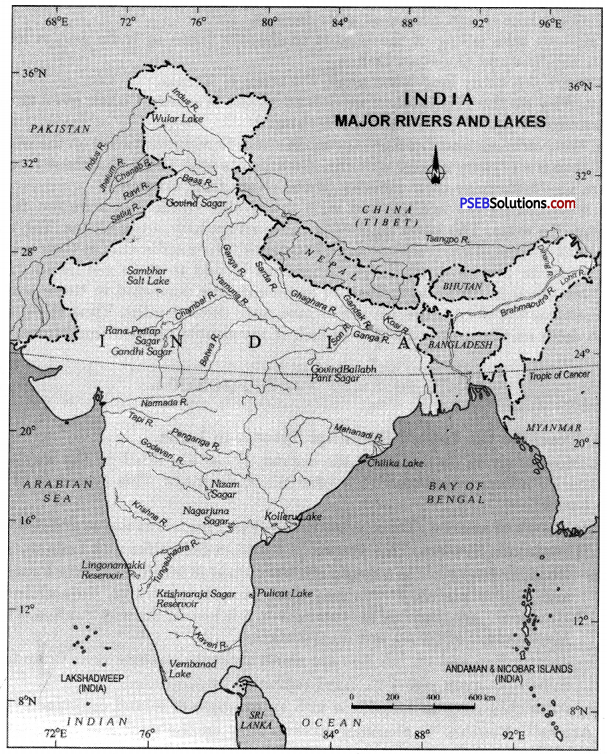
(i) Ganga
(ii) the Brahmaputra
(iii) Wular and Sambhar Lakes
(iv) Gobind Sagar Lake
Answer:
Do it yourself with the help of India Map.
Question 2.
Show in the outline map of India:
(i) Ganga with its tributries, three each on both sides.
(ii) Two peninsular rivers flowing towards west.
(iii) Three peninsular rivers flowing towards East and ending up in Bay of Bengal.
Answer:
Do it yourself with the help of India Map.
Objective Type Questions :
Answer the following questions in a single word to one sentence length :
Question 1.
Which among the following is not tributary of Ganga (Ganges) :
(i) Yamuna
(ii) Beas
(iii) Gandak
(iv) Son.
Answer:
(ii) Beas.
Question 2.
Which of these lakes is not natural :
(i) Renuka
(ii) Chilka
(iii) Dali
(iv) Ranjit Sagar.
Answer:
(iv) Ranjit Sagar.
![]()
Question 3.
Which drainage system is biggest in India :
(i) Ganga
(ii) Godawari
(iii) Brahmaputra
(iv) Indus.
Answer:
(i) Ganga.
Question 4.
Which is biggest delta of the world?
Answer:
Sundarban delta.
Question 5.
What is meant by Doab?
Answer:
The region between two rivers is called Doab.
Question 6.
What is length of Indus and how much of its portion lies in India?
Answer:
The total length of river Indus is 2800 km. and its 700 km. lies in India.
Question 7.
Name three peninsular rivers ending up in Bay of Bengal.
Answer:
Godawari, Krishna, Kaveri, Mahanadi.
Question 8.
In how many parts can be divide drainage system in India?
Answer:
Indian drainage system can be divided in four parts-Himalayan rivers, Peninsular drainage system, Internal drainage system and Lakes.
Question 9.
River Indus originates from which glacier?
Answer:
River Indus originates from Bokhar Chu glacier which is situated in Tibet.
Question 10.
Name any two seasonal rivers.
Answer:
Vetuma, Kalinadi, Subarnekha etc.
![]()
Question 11.
Which is birth place of Mahanadi? Name its two tributaries.
Answer:
The place of origin of Mahanadi is Dandakaranya in Chattisgarh. Seonath, Mang, Ong etc. are its tributaries.
Question 12.
Name five natural lakes of India.
Answer:
Dal lake, Chilka, Surajtal, Wooler, Khajiar, Pushkar etc.
Short Answer Questions :
Give short answers for the following questions :
Question 1.
Pollution is increasing in Ganga. What is being done to check it?
Answer:
There is no denying the fact that pollution in Ganga is continuously increasing. Its major reason is industrial waste, pesticides etc.
The government has taken many steps to stop pollution in Ganga such as :
- In April, 1980, Central Government made Ganga Action Plan and started the work of cleaning Ganga.
- In continuation with Ganga Action Plan, the government in 2009, created National Ganga Basic Authority and its major objective was to stop pollution in Ganga.
- In 2014, the Central Government created a special ministry for the cleaning of Ganga and a minister was also appointed for the same purpose.
- Till now, the Central Government has spent hundreds of crores for the cleaning of Ganga.
Question 2.
Write a note on Internal drainage in India.
Answer:
A number of rivers flow in India and many of these rivers fall into any sea. But there are few rivers which are unable to reach any sea and end midway within the country. They are known as Internal drainage system of India. Its most important example is river Ghaghar which flows for 465 km and then ends in Rajasthan. In the same way rivers flowing in Rajasthan and Luni river of Rajasthan are also few of its examples.
Question 3.
Which is Wridha’ Ganga? Name its tributaries.
Answer:
The Godavari is the longest of the Peninsular rivers. It has an extensive drainage basin. Its drainage basin extends through Maharashtra, Madhya Pradesh, Karnataka, Orissa and Andhra Pradesh. Because of its large size and extent, it is compared to river Ganga. It has got the same cultural significance in the peninsular India as the Ganga has in the northern plain. Therefore, it is referred to as Dakshina Ganga or Vridha Ganga.
Question 4.
On which river ‘Dhuandhar falls’ lies? Name its tributaries also.
Answer:
- DhuailtMlr Falls is on Narmada river which is formed at a place called Jabalpur in Madhya Pradesh.
- Major tributaries of river Narmada are the Shakkar, the Dudhi, the Tawa, the Ganjal, the Hiran, the Choral etc.
Long Answer Questions :
Answer the following questions in detail :
Question 1.
Which are Himalayan and Peninsular rivers? Differentiate between their characteristics.
Answer:
- Himalayan rivers: These rivers originate in the Himalayas mountain and they are called perennial rivers as they have water throughout the year. For example, Indus, Ganga, Brahmaputra etc.
- Peninsular rivers: Those rivers which are in the peninsular plateau or in south India are called Peninsular rivers. For example, Narmada, Tapi, Mahanadi, Godavari, Krishna, Kaveri etc.
Difference:
|
Himalayan Rivers |
Rivers of the Peninsula |
| 1. These rivers rise from the snow covered Himalayas and hence these are perennial. | 1. The Peninsular rivers are seasonal. They get supply of water from summer rainfall. |
| 2. These rivers do not have any waterfalls. Hence these are not useful for generation of water power. | 2. These rivers make waterfalls and cataracts on the plateau. Hence these are useful for hydroelectric projects. |
| 3. The Himalayan rivers have large basins and extensive catchment areas. Therefore, these have a large volume of water. | 3. The peninsular rivers have small basins and small catchment areas. Therefore these do not have a large volume of water. |
| 4. These rivers flow over plains. Therefore these are useful for irrigation and navigation. | 4. These rivers flow on rocky areas and are not used for irrigation and navigation. |
| 5. These rivers pass through deep gorges and before entering the plains they have meandering courses on plains. | 5. These rivers flow through shallow river valley having straight courses. |
| 6. These river form vast alluvial plains by depositing sediments. | 6. These rivers do not bring fertile alluvium and do not form alluvial plains. |
| 7. Many important towns have developed on the courses of these rivers. | 7. Very few towns have developed on the banks of these rivers. |
![]()
Question 2.
Describe three drainage systems of India and explain any” one of them in detail.
Answer:
Three river systems in India are Himalayan rivers, peninsular rivers and coastal rivers. Their description is given below:
I. Himalayan Rivers :
- River Indus. This river originates from Bokhar Chu glacier in the north of Mansarovar lake. It flows from south-east to north-west in Kashmir. On its way, Indus forms many deep gorges. While going through Pakistan, it falls in the Arabian sea. Sutlej, Ravi, Beas, Chenab and Jhelum are its major tributaries.
- River Ganga. River Ganga originates from Gangotri glacier at a place called Go-mukh. Later on Alaknanda and Mandakini rivers meet the Ganga. While flowing through Shiwalik mountains, it reaches Haridwar. Finally, it falls into the Bay of Bengal. Its major tributaries are Yamuna, Gomti, Ghaghra, Gandhak, Kosi, Chambal, Betwa, Son, etc.
- River Brahmaputra. This river originates from Angsi glacier in Kailash mountain of Tibet. While flowing through Tibat, India and Bangladesh, it meets the river Ganga. Here the water of Ganga and Brahmaputra rivers
flows with the name of Padma river. In the end, while forming Sunderban delta, it falls into the Bay of Bengal. It forms the Majuli island (Assam) which is the largest inter riverine island in the world. Manar, Subansri, Kameng etc. are the tributaries of Brahmaputra.
II. Peninsular Rivers :
- Mahanadi: This river originates from the Bastar hills at Dandakarnia in Chhattisgarh. While going through Chattisgarh and Odisha, it falls into Bay of Bengal.
- Godawari: This river originates from the northern side of western ghats. While going through Maharashtra and Andhra Pradesh, it falls into Bay of Bengal.
- Krishna: This river originates from Mahableshwar near western ghats. It also falls into Bay of Bengal while going through Karnataka and Andhra Pradesh. Its tributaries are Bhima, Tungabhadra etc.
- Kaveri: This river starts from the southern side of western ghats (Talakaveri) and falls into Bay of Bengal. On its way, it flows through Karnataka and Tamilnadu.
- Narmada: This river originates from Amarkantak and goes through Maikal hills and finally falls into Arabian Sea.
- Tapti: This river originates from the Betul district of Madhaya Pradesh in the Satpura range. It also falls into Arabian Sea.
III. Coastal Rivers :
There lie three seas on the southern part of India and these are Arabian Sea, Bay of Bengal and Indian Ocean. The rivers flowing along with the coast of these seas are known as coastal rivers. Their length is quite less and they flow through a very short span of length. They are-filled with water in the rainy season. Major coastal rivers are Veluma, Palar, Mandavi, Dapaira, Kalinadi, Sheravati, Netravati, Periyar, Painani, Subarnekha, Kharkai, Palar etc,
Question 3.
What are economic benefits of North Indian and South Indian rivers? ‘
Answer:
1. Cultural Importance. Rivers have been of fundamental importance throughout the human history. The areas along the banks of rivers have witnessed great cultural and economic progress since ancient times. Rivers are an integral part of our folklore and folk songs.
2. A Natural Resource. Water from the rivers is a basic natural resource, essential for human, agricultural and industrial activities.
3. Agricultural Areas. Rivers and their associated alluvial soils provide the most productive agricultural lands of the country. The Ganga, the Kaveri and other deltas have traditionally been the rice growing areas. An agriculture dependent on the vagaries of the monsoons, irrigation from rivers has been the backbone of the development of Indian agriculture.
4. Settlements. The valleys contain dense and concentrated settlements. Most of the large cities are located on rivers. Not only do rivers provide us with essential water supplies, but they also receive, dilute and transport “wastes from settlements.
5. Industrial Development. Industrial development has flourished along rivers as many industrial processes rely on water – as a raw material, as a coolant and for the generation of hydro-electricity.
6. Transportation. Rivers provide primary channels of inland transportation, not only directly in the form of navigable waterways, but also indirectly through their valleys, where roads, railways lines and other routes are built.
7. Tourism. Recreation, tourist promotion and fishing are also being developed along waterfronts.
PSEB 9th Class Social Science Guide India: Drainage Important Questions and Answers
Multiple Choice Questions :
Question 1.
Which is the-largest river basin in, India?
(a) Ganga
(6) Yamuna
(c) Mahanadi
(d) Godawari.
Answer:
(a) Ganga.,
Question 2.
Which is the longest river of India?
(a) Yamuna
(6) Ganga
(c) Brahmaputra
(d) Godavari.
Answer:
(c) Brahmaputra
![]()
Question 3.
The drainage system with branches resembles a tree :
(a) Trellis
(b) Radial
(c) Dendritic
(d) Rectangular
Answer:
(c) Dendritic.
Question 4.
The Ganga and the Yamuna rivers meet at :
(a) Kanpur
(b) Varanasi
(c) Patna
(d) Allahabad.
Answer:
(d) Allahabad.
Question 5.
Sunderban delta is formed by :
(a) Ganga
(b) Kaveri
(c) Godavari
(d) Narmada.
Answer:
(a) Ganga.
Question 6.
Which is a trans-Himalayan river?
(a) Ganga
(b) Chambal
(c) Sutlej
(d) Beas.
Answer:
(c) Sutlej.
Question 7.
Which river is called Dakshin Ganga?
(a) Mahanadi
(b) Godavari
(c) Krishna
(d) Cauvery.
Answer:
(b) Godavari.
Question 8.
Where is Dal lake located?
(a) In Arunachal
(b) In Kerala
(c) In J & K
(d) In Rajasthan.
Answer:
(c) In J & K.
![]()
Question 9.
Which lake is located in Orissa?
(a) Chilka
(b) Sambhar
(c) Vembnad
(d) Kolleru.
Answer:
(a) Chilka.
Fill in the blanks :
Question 1.
Total length of the river Ganga is _________ km.
Answer:
2525
Question 2.
Ghaghra, Gandhak, Kosi, Sone are the tributaries of river _________
Answer:
Ganga
Question 3.
Brahmaputra enters India at a place called _________
Answer:
Namcha Barva
Question 4.
Total length of the river Brahmaputra is _________ km.
Answer:
2900
Question 5.
_________ island is the largest inter riverine island in the world.
Answer:
Mojuli
![]()
Question 6.
Luni river originates at _________ in Rajasthan.
Answer:
Pushkar.
True/False:
Question 1.
Sabarmati river originates from Dabar lake.
Answer:
True
Question 2.
Length of Luni river is 495 km.
Answer:
True
Question 3.
Krishna river is also known as Vridha Ganga.
Answer:
False.
Question 4.
Coastal rivers are quite long.
Answer:
False.
Question 5.
Gobind. Sagar lake is made behind Bhakhra Dam.
Answer:
True
Question 6.
Ganga Action Plan was made in 1980.
Answer:
False.
Very Short Answer Type Questions
Question 1.
What is meant by Drainage?
Answer:
The web of rivers flowing in any area is called drainage.
![]()
Question 2.
What is Doab?
Answer:
The region between two rivers is called Doab.
Question 3.
What is water divide?
Answer:
An upland area separating two drainage basins is called a water divide.
Question 4.
What do you mean by Drainage Basin?
Answer:
The area drained by a single river system is called a drainage basin.
Question 5.
What is Drainage Pattern?
Answer:
When flowing water on land forms different patterns, it is called drainage pattern.
Question 6.
Name the types of drainage pattern.
Answer:
Dendritic pattern, Trellis pattern, Radial pattern and Rectangular pattern.
Question 7.
In which four parts can we divide Indian drainage system?
Answer:
Himalayan rivers, Peninsular rivers, Coastal rivers and Internal drainage system.
Question 8.
Which are the major water divides of India?
Answer:
Himalayan Mountain ranges and Deccan Plateau of South.
Question 9.
Name the tributaries of river Indus.
Answer:
Sutlej, Ravi, Chenab and Jhelum.
Question 10.
Name the tributaries of river Ganga.
Answer:
Yamuna, Son, Ghaghra, Ghandhak, Betwa, Kosi etc.
Question 11.
Which rivers are the examples of Antecedent Drainage?
Answer:
Indus, Sutlej, Alakhnanda, Ghandhak, Kosi and Brahmaputra.
Question 12.
What do we call river Indus in Tibet?
Answer:
In Tibet, river Indus is called Singhi Khamban or Sher Da Mukh.
Question 13.
What is the total length of river Indus?
Answer:
2880 km.
![]()
Question 14.
Which river is known as the holy river in India?
Answer:
River Ganga is considered as the holy river in India.
Question 15.
Which delta is formed by the Ganga and Brahmaputra rivers?
Answer:
Sunderban Delta.
Question 16.
What is the total length of Ganga river?
Answer:
2525 km.
Question 17.
From where Brahmaputra river originates?
Answer:
Brahmaputra river originates from Angsi glacier in Kailash mountain, Tibet.
Question 18.
What do we call Brahmaputra river in Tibet?
Answer:
Brahmaputra river in Tibet is called Tsangpo.
Question 19.
At which place Brahmaputra river enters India?
Answer:
Brahmaputra river enters India at Namcha Barva.
Question 20.
Name the tributaries of Brahmaputra.
Answer:
Subarnagiri, Kamera, Dhangiri, Dihang, Lohit etc.
Question 21.
What is the name of main stream of river Ganga?
Answer:
Bhagirathi.
Question 22.
Which southern rivers flow in the west direction?
Answer:
Narmada and Tapti rivers.
Question 23.
Which southern rivers flow in the east direction?
Answer:
Mahanadi, Godawari, Krishna and Kaveri.
Question 24.
What do you mean by Inland drainage system?
Answer:
Many of the rivers in country ends in land or in any lake, They do not fall in any sea and it is called Inland drainage system.
![]()
Question 25.
Name any three rivers of Inland drainage system.
Answer:
Ghagar river, Luni river, Saraswati river etc.
Question 26.
Where are natural lakes available in the peninsular plateau?
Answer:
Lonar (Maharashtra), Chilka (Odisha), Pulikat (Tamil Nadu), Periyar (Kerala), Kelur (Seemandhra) etc.
Question 27.
What is the length of Chilka lake and where is it situated?
Answer:
The length of Chilka lake is 30 km. and it is situated in Odisha.
Question 28.
When and why was Ganga Action Plan launched?
Answer:
Ganga Action Plan was launched in 1986 to stop the pollution in Ganga.
Question 29.
What is the total length of Mahanadi?
Answer:
858 km.
Question 30.
What is the length of Godawari, Krishna, Kaveri and Narmada?
Answer:
Godawari: 1465 km, Krishna: 1400 km.
Kaveri: 800 km., Narmada: 1312 km.
Question 31.
Name the tributaries of Godawari.
Answer:
Dhanganga, Vangaga, Vardha, Indrawati, Manjra, Sabri etc.
Question 32.
Name the tributaries of Kaveri.
Answer:
Herawati, Hiranegi, Amravati, Kabani.
![]()
Question 33.
Name the tributaries of river Tapti.
Answer:
Girna, Mindola, Poorna, Panjag, Shipra, Arunavati etc.
Question 34.
Tell something about Luni river.
Answer:
Luni river starts from Pushkar, Rajasthan. Its length is 465 km and it ends in the Kutch of desert.
Question 35.
Name the major lakes of Jammu and Kashmir.
Answer:
Dal lake and Wooler lake.
Question 36.
Name the Salty lake of Rajasthan.
Answer:
Sambhar Lake.
Question 37.
Which chemicals are thrown in the rivers?
Answer:
Cadmium, Arsenic, Lead, Magnesium, Zink, Nickel etc.
Short Answer Type Questions
Question 1.
Why Himalayan rivers are called the perennial rivers?
Answer:
The meaning of perennial is the one which flows throughout the year. Himalayan rivers get water in summer as well as in winter. During rainy,season, they get rain water. During summer season, the snow of Himalaya gets melted and water comes in the rivers. That’s why Himalayan rivers are called the perennial rivers. Ganga and Brahmaputra are such rivers.
Question 2.
Name the three main Himalayan river systems. Also write two tributaries of each one.
Answer:
There are three Himalayan river systems and they are :
- Indus River System. Its major tributaries are Sutlej, Ravi, Beas, Chenab etc.
- Ganga River System. Its major tributaries are Yamuna, Ganga, Gomti, Gandak, Sone etc.
- Brahmaputra River System. Its major tributaries are Dibhang, Lohit etc.
Question 3.
Give a brief description of Brahmaputra river.
Answer:
The Brahmaputra is the longest river in India, with a length of about 2880 kms. It rises near Mansarover lake in Tibet and enters India through Dihang gorge in Arunachal Pradesh. It flows parallel to the Himalayas in Tibet where it is known as ‘Tsangpo’. After Namcha Barwa (7767 m), it takes ‘U’ turn and enters India in Arunachal Pradesh through Dihang gorge. Dihang gorge is about 13000 metres deep. After the confluence of Lohit, Dihang and Dibang streams, it is called the Brahmaputra. It carries huge amount of silt with it. In northern Bangladesh, it is called Padma. Further south, the Ganga and the Brahmaputra meet and the joint stream is known as Jamuna and in central part, it is called Meghna. It is often compared to a slowly moving lake due to sluggish flow. It is known for its notorious floods in upper Assam. It forms the largest delta of the world, known as ‘Sunderbans’. It is the home of ‘Royal Bengal Tiger’.
Question 4.
Write a note on Ganga river system.
Answer:
The Ganga is the most sacred river of India. The story of the Ganga from her source to sea from old times to new is the story of India’s civilisation and culture. The Ganga has its source near Gomukh glacier, near Gangotri. The Ganges is formed by two head streams namely Alaknanda and Bhagirathi. It enters the plains near Hardwar. The Yamuna meets this river at Allahabad known as Sangam. The Ganges is the master stream of the area—South of Farakka, the river divides into a number of channels to form ‘Sunder Ban’ Delta. The Ramganga, Ghaghra, Gandak, Baghmari join the Ganges from its left. The Yamuna and the Son join it from the south. It is 2525 km long. Hardwar, Kanpur, Allahabad, Varanasi, Patna and Kolkata are situated along the Ganga.
![]()
Question 5.
Describe the .west flowing rivers of peninsular plateau.
Answer:
The rivers flowing to the west of Peninsular plateau are: Mahi, Sabarmati, Narmada and Tapti.
- Mahi. Mahi river emerges from Vindhya mountains. It total length is 533 kilometres. It falls into the right side of Gulf of Khambhat, near gulf of Cambay.
- Sabarmati. Sabarmati emerges from Mechhva near Udaipur. This seasonal river is 416 km. long. After passing through Gandhi Nagar and Ahmedabad, it falls into Gulf of Cambay.
- Narmada. It emerges from Amarkantak Plateau, and after travelling 1312 km, falls into the south of Gulf of Cambay without forming any delta.
Question 6.
Describe the east flowing rivers of peninsular plateau.
Answer:
- Damodar River. The Damodar, 530 km long, rises from Chhota Nagpur plateau. On account of its floods, it is called ‘River of Sorrow’. D.V.C. Project is a multipurpose project to get benefits from this river.
- The Mahanadi. It is 857 km long. It emerge from Amarkantak Plateau. It is a navigable river and forms a fertile delta.
- The Godavari. It is 1440 km long and rises from the Western Ghats. It is the longest river of the Peninsula. It forms a fertile delta on the East Coast.
- The Krishna. It is 1400 km long. It rises near Mahabaleshwar in Western Ghats. Its tributaries – Bhima and Tungbhadra are important.
- Kaveri. It rises in Brahmgiri in the Coorg district. It is 800 km. long. It is useful for irrigation, navigation and water power development.
Question 7.
State few characteristics of Himalayan rivers.
Answer:
These rivers have large basins. These make deep gorges. These were formed due to down cutting during period of uplift of Himalayas. These are perennial rivers as these get water from rainfall and from the melting of snow. These deposit silt and sand to form plains.
Question 8.
Write a note on the Indus river system.
Answer:
The Indus River System. The river Indus rises in Tibet, near Lake Mansarovar. Flowing west, it enters India in the Ladakh through a picturesque gorge. Several tributaries, the Zaskar, the Shyok and the Huzana, join it in this region. It flows through Baltistan and Gilgit and emerges from the mountains at Attock. The famous five rivers of Punjab—the Satlej, the Beas, the Ravi, the Chenab and the Jhelum enter the Indus a little above Mithankot in Pakistan. Beyond this, the Indus flows southwards eventually reaching the Arabian Sea, east of Karachi. The total length of the river is about 2900 km. ranking it amongst the longest rivers of the world. A little over a third of the Indus basin is located in India in the states of Jammu and Kashmir, Himachal Pradesh and the Punjab and the rest is in Pakistan.
Question 9.
Write a note on Lakes in India.
Answer:
There are not many lakes in India. Dal, Wular, Sambhar, Chilka, Pulikat, Lonar etc. are the major lakes in India.
- Out of all the lakes, seven are in the Nainital district of the Kumaon Himalayan region.
- Dal and Wular lakes are in North Kashmir. These are quite good for entertainment purposes.
- Sambhar Lake in Rajasthan and Lonar lake in Maharashtra are salt water lakes.
- Chilka lake in Odisha is India’s largest salt water lake.
- Pulikat lake near Chennai is quite famous.
- Kolleru lake is one of the largest freshwater lakes in India and is located between Krishna and Godavari Deltas.
- There are many long lakes along the coast of Kerala.
![]()
Question 10.
Why do the rivers have no deltas on the Western Coast, even though they transport lot of sediments with them ?
Answer:
The Narmada and Tapti are the main rivers flowing westward on the western coast. These rivers carry a large amount of sediments with them. But these rivers do not form any delta near their mouths. These rivers form estuaries.
The west coasts are not marked with favourable conditions required for the formation of a delta. The lower courses of these rivers have steep slopes. The rivers have a swift current. The rivers are unable to deposit their sediments at their mouths. These rivers do not have any large tributaries to add to their sediments. These rivers flow through rift valleys. Most of sediments are deposited in these troughs. Due to subsidence, deep estuaries are formed near their mouths. Thus these rivers have no delta on the west coast due to lack of favourable physical conditions.
Long Answer Type Questions
Question 1.
Describe the Inland Drainage System in India.
Answer:
Most of rivers do not reach the oceans. These are dried on the way or fall into lakes. So inland water resources form inland drainage. This system is studied on two bases :
On the basis of source : These systems developed from Himalayas and Aravallis.
(a) Himalayan System. This system is found in Shiwaliks and Ladakh.
- Ghaggar river rises to a height of 1500 metres in Morni Hills over Panchkula and enters plains. It reaches upto Punjab, Haryana, Rajasthan upto Hanumangarh. But due to evaporation, it is lost on the way Sukhna, Tangri, Markanda, Saraswati are its tributaries.
- Jaintia Rao and Patiali Rao are small seasonal streams near Chandigarh.
- Sub-Himalayan rivers in Terai region go underground.
- Aksaichin river in Ladakh is also an example of inland drainage system.
(b) Aravalli Region:
- Seasonal streams flow on the west and enter lakes of Sambhar, Jaipur, or in sand dunes.
- Luni River enters Rann of Kutchh.
(c) Destination Basis. Many small streams reach into lakes, which are found in Himalayas, Thar desert, and peninsular India.
- Lakes of the Himalayas,
(a) Dal lake, Wular, Anantnag, Sheshnag, Verinag lakes in Kashmir
(b) Bheem Tal, Chanderpal Tal, Nainital, Punatal, etc. lakes in Kumaon. - Lakes of Thar Desert. Sambhar, Salt lake, Javadi, Choparward, Sai pad, Jasmand lakes.
- Peninsular India lakes. Lonar in Maharashtra, Chilka (Odisha), Pulicat (T.N.), Periyar (Kerala).
Question 2.
Describe the drainage system flowing into the Bay of Bengal and Arabian Sea.
Answer:
1. The Ganges. The Ganges has its source near Gomukh glacier, near Gangotri. The Ganges is formed by two land streams namely Alaknanda and Bhagirathi. It enters the plains near Haridwar. The Yamuna meets this river at Allahabad known as Sangam. The Ganges is the master stream of the area. South of Farakka, the river divides into a number of channels to form ‘Sunder Ban’ Delta.
2. The Brahmaputra System. The Brahmaputra river is the master stream of this system. It is 2880 km long. It flows parallel to the Himalayas in Tibet and is known as Tsangpo. It enters India in Arunachal Pradesh through Dihang gorge. It is known for its notorious floods and silt deposits. It joins Padma river in Bangladesh to form a large delta.
The Drainage System flowing into Arabian Sea.
1. The Indus Drainage System. It is one of the world’s largest systems. It comprises the rivers of Indus, Jhelum, Chenab, Ravi, Sutlej and Beas. Indus., Jhelum and Chenab flow in Pakistan.
- The Sutlej: It originates from Rakshas Tal near Mansarover lake across the Himalayas. It forms a deep gorge. It is 1448 km long and feeds the Bhakhra Canal.
- The Beas: It originates from the Beas Kund near Rohtang Pass. It is 460 km long. It lies within the boundaries of Punjab state.
- The Ravi: The Ravi rises in Dhauladhar Hills. It enters the plains near Madhopur. It is 720 km. long and forms a natural divide between India and Pakistan.
2. Other Rivers. Narmada and Tapti make estuaries along the west coast. These are rift valleys. Sabarmati, Luni, Mahi are other rivers.
![]()
Question 3.
Describe the different drainage patterns.
Answer:
The streams of an area form patterns. These drainage patterns depend upon :
- Relief of Area
- Structure of Area
- Climatic conditions of Area
The streams form the following patterns :
1. Dendritic pattern. It consists of a single main stream. The tributaries resemble the branches of a tree. These follow the slope of the area. Ganges river is dendritic in pattern. The word dendritic is derived from the Greek word dendran.
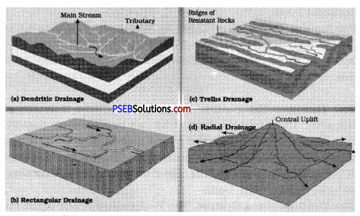
2. Trellis pattern. In this, the mainstream is joined by short flowing streams. These streams join the mainstream at right angles. It makes a rectangular pattern. Narmada river makes a Trellis pattern.
3. Radial pattern. In this, the stream flows in different directions from a central peak or dome-like structure.
4. Inland drainage. In this pattern, the rivers do not reach an ocean. It falls into a lake or an inland sea. It is formed in the desert at Rajasthan.
5. Rectangular pattern. It is developed on a strongly connected terrain. The drainage follows the joint patterns.