Punjab State Board PSEB 9th Class Social Science Book Solutions Geography Chapter 2b Punjab: Physical Features or Physiography Textbook Exercise Questions and Answers.
PSEB Solutions for Class 9 Social Science Geography Chapter 2b Punjab: Physical Features or Physiography
SST Guide for Class 9 PSEB Punjab: Physical Features or Physiography Textbook Questions and Answers
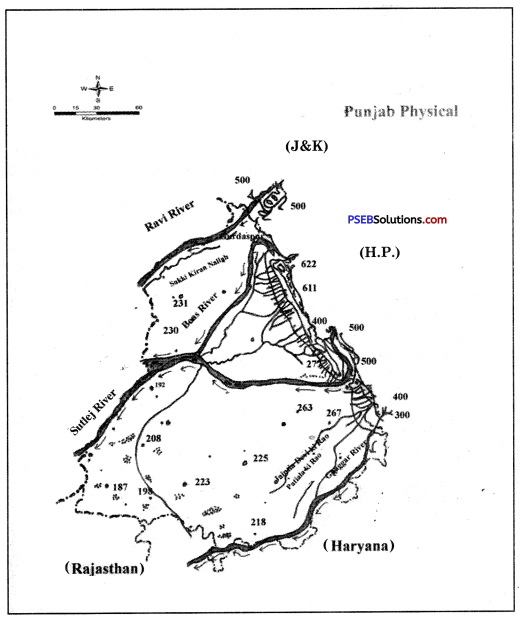
Map Work:
Show the outline map of Punjab:
(i) Hoshiarpur Shiwalik and Ropar Shiwaliks.
(ii) Bet region of river Sutlej.
Answer:
Do it yourself with the help of India Map.
Activity:
Prepare three lists of districts of semi-mountainous, plains and south-western sandy regions to display in your classroom.
Answer:
Do it yourself.
Objective Type Questions:
Answer the following questions in a single word to one sentence length.
Question 1.
What are old alluvial plains known as?
Answer:
Bhangar.
Question 2.
What do you understand by khadar or Bet?
Answer:
Khadar or Bet are the plains of new alluvial soil. This soil exists in the lower areas of river banks.
![]()
Question 3.
In how many classifications can we divide Punjab plains?
Answer:
The plains of Punjab can be divided in five parts:
- Plains of Cho region,
- Flood plains,
- Naili,
- Alluvial Plains,
- Sand dunes in alluvial plains.
Question 4.
In which direction sandy highlands fall in Punjab?
Answer:
Sand dunes in Punjab are available in south-west side along with the Rajasthan border.
Question 5.
What is meant by Changa?
Answer:
The Kandi region near Anandpur Sahib is known as Changar.
Question 6.
Which of the following is right and which is wrong:
1. The outermost range of Himalayas is Shiwaliks.
Answer:
True.
2. Kandi region falls in south of Roopnagar and Patiala.
Answer:
False
3. Hoshiarpur Shiwalik falls between Sutlej and Beas.
Answer:
True.
4. Alluvial plains of Ghagar in south-east Punjab are known as Nally.
Answer:
True.
Short Answer Questions:
Give short answer for the following questions:
Question 1.
Explain characteristics of Kandi region. In which districts of Punjab does it fall?
Answer:
There exist open plains in the west of Punjab’s Shiwalik hills and in the east of Nurpur Bedi Tehsil of Roopnagar district. In local language, they are called Kandi areas.
This area or region is spread in 5 lakh hectare area of 5 districts and 22 blocks of Punjab which becomes 10% of Punjab’s total area.
Features:
- The soil of this region is not smooth and is full of Chos.
- This region is spread in the narrow bets of 300-400 metres along with Shiwalik.
- After every kilometre, there exists one Cho or Nala.
- This region is spread between the districts of Chandigarh, Hoshiarpur, Roopnagar (Ropar) etc.
![]()
Question 2.
What are seasonal Choes? Give examples of these rivelets.
Answer:
Few Chos flow in the rainy season. They become dry in the summer season. Such Nalas are known as seasonal Chos. There exist a number of seasonal Chos in Roopnagar of Ropar Shiwalik. Here they are called Rao and Ghare.
Question 3.
Write a note on origin of alluvial plains of Punjab.
Answer:
Punjab’s 70% land is surrounded with alluvial plains. These plains are the part of Ganga and Indus plains. They originated due to the soil brought up by the parennial rivers of the Himalaya mountain. Indus and its tributaries such as Sutlej, Ravi and Beas have played a very important role in its formation. Their height is 300 metres to 2000 metres from sea level.
Question 4.
Write a note on Gurdaspur-Pathankot Shiwaliks.
Answer:
Gurdaspur-Pathankot Shiwalik mountain range is spread in the Gurdaspur and Pathaiikot districts. Dhar Kalan Block of Pathankot district is completely situated in the Shiwalik hills. The average height of these hills is around 1000 metres.
The hill slopes of this region are cut down due to fast flowing water with which deep trenches become gullies. The seasonal rivers flowing in this region, Chaki Khad and its tributaries flow into Beas river.
PSEB 9th Class Social Science Guide Punjab: Physical Features or Physiography Important Questions and Answers
Multiple Choice Questions:
Question 1.
What type of land has Punjab?
(a) Mountains
(b) Plains
(c) Plateau
(d) Desert.
Answer:
(b) Plains.
Question 2.
The Shiwalik hills of Punjab originated due to the collision of
(а) Gondwana land and Dabar plains
(b) Angara land and Shiwalik plains
(c) Gondwana land and Eurasia plate
(d) Angara land and Eurasia plate.
Answer:
(c) Gondwana land and Eurasia plate.
Question 3.
Another name of Bari Doab is:
(a) Malwa
(b) Chaj
(c) Naili
(d) Majha.
Answer:
(d) Majha.
Question 4.
Terai region which is full of Chos in Punjab is known as
(a) Kandi
(b) Bari Doab
(c) Bet
(d) Bolla.
Answer:
(a) Kandi.
![]()
Question 5.
Alluvial plains of Ghagar are called
(a) Cho
(b) Naili
(c) Tethys
(d) None of these.
Answer:
(b) Naili.
Fill in the blanks:
Question 1.
Sand dunes exist in the __________ region of Punjab.
Answer:
south-west
Question 2.
Kandi region is __________ % of the total region of Punjab.
Answer:
10
Question 3.
Kandi region near Sarsa river is known as __________
Answer:
Ghere
![]()
Questions 4.
70% of Punjab’s land is __________ plains.
Answer:
Alluvial
Question 5.
Punjab plains are the parts of __________ and __________ plains.
Answer:
Ganga, Indus.
True/False:
Question 1.
Punjab’s Shiwalik range touches Rajasthan.
Answer:
False
Question 2.
Talwara is the highest block of Hoshiarpur Shiwalik.
Answer:
True.
Question 3.
Gurdaspur-Pathankot Shiwalik hills are spread from Ravi to Beas.
Answer:
True.
Question 4.
Ropar Shiwalik’s length is 1900 kms.
Answer:
False
![]()
Question 5.
The region between Ravi and Sutlej rivers is known as Bari Doab.
Answer:
True.
Very Short Answer Type Questions
Question 1.
On which side of Punjab the Shiwalik hills are situated?
Answer:
East and North-west side.
Question 2.
The Shiwalik hills of Punjab touch the boundaries of which state?
Answer:
Himachal Pradesh.
Question 3.
What is the average height of Shiwalik hills of Punjab?
Answer:
600 metres to 1500 metres.
Question 4.
Which block of Pathankot district is completely situated in the Gurdaspur-Pathankot Shiwalik hills?
Answer:
Dhar Kalan.
Question 5.
Which is the highest block of Hoshiarpur Shiwalik?
Answer:
Talwara (741 metres).
Question 6.
Name two major Chos of Hoshiarpur Shiwalik.
Answer:
Kot – Mairan.
![]()
Question 7.
Due to which river, the continuity of Ropar Shiwalik range breaks down?
Answer:
Due to a tributary of Sutlej river-Sarsa.
Question 8.
In which physical units the alluvial plains of Punjab are divided?
Answer:
Bari Doab, Bist Doab, Sij Doab.
Question 9.
Where can we find the Dhaiya of changing course of rivers?
Answer:
At Philaur.
Question 10.
What do we call the higher regions away from rivers in the alluvial plains of Punjab?
Answer:
Bang.
Question 11.
What is the, approximate length of Shiwalik hills of Punjab?
Answer:
280 km.
Question 12.
What do we call the southern part of Hoshiarpur Shiwalik?
Answer:
Kataar di Dhaar.
![]()
Question 13.
Give length and breadth of Hoshiarpur Shiwalik.
Answer:
- Length – 130 kilometres
- Breadth – 5 – 8 kilometres.
Short Answer Type Questions
Question 1.
“There exists diversity of land in Punjab.’ Give exmaple.
Answer:
If we look at the physical map of India, we can observe that it is a plain but from physiographic point of view, there exists too much diversity of land over here. The most fertile plains of the world lie in Punjab. In the east and north-east of Punjab, there exist Shiwalik hills. Sand dunes are also there in the south-west region of Punjab.
Question 2.
Discuss the spread of Shiwalik hills in Punjab.
Answer:
Shiwalik. hills are the part of outer Himalaya. These mountains are spread for 280 km. along with the boundary of Himachal Pradesh in the eastern Punjab.
Shiwalik hills are divided into three parts:
- Gurdaspur-Pathankot Shiwalik. These hills are spread upto Ravi and Beas rivers.
- Hoshiarpur Shiwalik. These hills are spread upto Beas and Sutlej rivers.
- Ropar Shiwalik. They are spread upto Sutlej and Pathar rivers.
Question 3.
Where and how was Kandi region of Punjab formed?
Answer:
Kandi region is formed in the foothill plains of Terai region of Shiwalik. Alluvial-Pankh played an important role in their formation. These geo-compositions meet each other in Terai plains and create the Kandi region. The underground level of water in this region is quite low.
Question 4.
Give four features of Ropar Shiwalik.
Answer:
- This range of Shiwalik lies between Sutlej and Ghagar rivers. It is spread in Roopnagar district and towards south-west direction and towards north-west direction of the boundaries of Himachal Pradesh.
- These mountains start from the north of Nangal and are stretched upto Ghaghar river near Chandigarh.
- The length of this range is 90 km. Its continuity breaks down due to Sarsa river, a tributary of Sutlej.
- Like other Shiwalik ranges, this range is also full of Chos.
Question 5.
Make a list of Alluvial plains of Punjab according to Doabs.
Answer:
Alluvial Plains of Punjab:
|
Bari Doab |
Bist Doab |
Sij-Doab |
| (Beas-Ravi) | (Beas-Sutlej) | (Sutlej-Y amuna) |
| Ravi Sakki Kiran | West Doab | Kotkapura Pathar |
| Sati-Kiran-Udiyar | Manjri Doab | Naili |
| Tendiara-Kasoor | Dhak Doab | Puadh |
| Kasoor-Patti | Bet/Khadar | Flood Plains |
| Patti-Beas | Sand Dunes |
Question 6.
How were Shiwalik mountains (hills) formed?
Answer:
The outermost range of the Himalayas is called the Shiwaliks. They extend over a width of 10-50 km and have an altitude varying between 900-1100 metres. These ranges are composed of unconsolidated sediments brought down by rivers from the main Himalayan ranges located farther north. Shiwalik hills were formed from the Tethys sea like Himlayas. With the collision of Eurasia plate with Gondwana land, the land moved up and took the form of mountains.
![]()
Question 7.
Which is the largest area of Punjab Plains? Name the districts included in it.
Answer:
The largest area of Punjab’s Plains is Malwa. It includes many districts of Punjab such as Firozpur, northern part of Faridkot, Moga, Ludhiana, Barnala, Sangrur, Patiala, Western Roopnagar, Sahibzada Ajit Singh Nagar (Mohali), Fatehgarh Sahib etc.
Question 8.
Name any two Doabs of Punjab and write about the districts included in them.
Answer:
Bari Doab and Bist Doab are the two major Doabs of Punjab. Their description is given below:
- Bari Doab. The region between Ravi and Sutlej rivers in Punjab is known as Bari Doab. It is also known as Majha region. It includes the districts of Pathankot, Gurdaspur, Amritsar and Taran Taran.
- Bist Doab. The region between Beas and Sutlej rivers is known as Bist Doab. It includes the districts of Jalandhar, Kapurthala, Hoshiarpur and Sahid Bhagat Singh Nagar (Nawanshahar).
Question 9.
Give a brief description of the Sand Dunes situated in the south-west part of Punjab.
Answer:
Along with Rajasthan border in the south-west of Punjab, we can find Sand Dunes at many places. Such sand dunes are available in the southern parts of Bathinda, Mansa, Fazilka, Faridkot, Sangrur, Muktsar and Patiala. Few sand dunes are also available in the central part of the Ferozpur disctrict. The slope of these sand dunes is not gentle.
The climate of this region is semi dry. Efforts are on to flaten the sand dunes to provide land for agriculture. The hardworking farmers of Punjab have developed agriculture over here with the help of irrigation. That’s why the natural physical feature of this region has disappeared.
Long Answer Type Question
Question 1.
In how many parts can we divide the surface of Punjab? Explain in detail about the Shiwalik hills.
Answer:
There is no denying the fact that Punjab is famous in the whole world for its large fertile plains. But Punjab is not only a plain region. There is lot of great diversity in its land. There exist Shiwalik hills in the east and north-east direction of Punjab. Sand dunes are also there in the southwest region of Punjab.
The surface of Punjab can be divided in following parts:
- Shiwalik hills
- Large Alluvial plains
- Sand Dunes of south-west.
Shiwalik hills are the part of outer Himalayas. These mountains are spread in the east of Punjab for 280 km. along with the borders of Himachal Pradesh. The average breadth of this mountain range is 5-12 km. and average height from sea level is 600-1500 metre.
Parts of Shiwalik Hills. Shiwalik hills can be divided in three parts:
- Upto Pathankot Ravi and Beas, Gurdaspur-Hoshiarpur Shiwalik.
- Upto Beas and Sutlej rivers.
- Upto Sutlej and Ghaghar, Ropar Shiwalik.
Their description is given below:
1. Gurdaspur-Pathankot Shiwalik. This mountain range is spread in Gurdaspur and Pathankot districts. Dhar Kalan block of Pathankot district is completely situated in the Shiwalik hills. The average height of these mountains is 1000 metre. The mountain slopes of this region are cut down due to fast flowing water which forms the gullies. This region has many seasonal rivers such as Chaki Khad and they meet the Beas river.
2. Hoshiarpur Shiwalik. The region of Hoshiarpur Shiwalik is spread between Beas and Sutlej rivers and in Hoshiarpur, Shahid Bhagat Singh Nagar (Nawanshahar and Nurpur Bedi of Roopnagar district). Its length and breadth is 130 km and 5-8 km respectively. Hills in the north are quite wide but they are narrow in the south.
The highest block in this region is Talwara and its height is 741 metres. These slopes of Shiwalik are the victims of Gully erosion. After almost every kilometere, we can find a Cho. Due to head-ward erosion of these Chaos, these hills are cut down at many places. In the south of Hoshiarpur, they are called ‘Katar di Dhar’. Its middle part is situated in the east of Garhshankar. Kot, Mairan, Dalle di Khad are major Chos of this region.
3. Ropar Shiwalik. This range of Shiwalik is situated between Sutlej and Ghagar rivers. It is spread in the Roopnagar district in the northwest to southeast along with the borders of Himachal Pradesh. These mountains start from the north of Nangal and are stretched up to the Ghaghar river near Chandigarh.
The length of this range is 90 km. Its continuity breaks down due to the Sarsa river, a tributary of Sutlej. Like other Shiwalik ranges, this range is also full of Chaos. Here these are called Rao and Ghere.