Punjab State Board PSEB 9th Class Social Science Book Solutions Geography Chapter 1b Punjab: Size and Location Textbook Exercise Questions and Answers.
PSEB 9th Class Social Science Solutions Geography Chapter 1b Punjab: Size and Location
SST Guide for Class 9 PSEB Punjab: Size and Location Textbook Questions and Answers
Map Work :
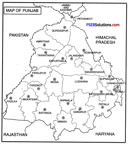
Show in an outline map of Punjab:
(i) Six districts of Punjab adjoining the international border.
Answer:
Do it yourself with the help of India Map.
(ii) The capital and 22 District headquarters of Punjab.
Answer:
Do it yourself with the help of India Map.
Objective Type Questions :
Answer the following questions in a single word to one sentence length :
Question 1.
What is literary meaning of word Punjab?
Answer:
The word Punjab is made up of two Persian words-Punj and Aab which mean five rivers.
Question 2.
Give full form of PEPSU.
Answer:
Patiala and East Punjab States Union.
Question 3.
What are Latitudinal and Longitudinal extent of Punjab?
Answer:
The Latitudinal extent of Punjab is 29°30′ N to 32°32′ N and its Longitudinal extent is 73° 55′ E to 76°50′ E.
Question 4.
What are ancient names of Ravi, Beas and Satluj?
Answer:
Purushivi, Vipasha and Satudari are the ancient names of Ravi, Beas and Satluj respectively.
![]()
Question 5.
Which of the following districts do not touch International boundary?
(i) Pathankot
(ii) Faridkot
(iii) Fazilka
(iv) Taran Taran.
Answer:
Faridkot.
Question 6.
Which Pair among the following is not correct :
(i) Batala : Agricultural Implements Industry
(ii) Jalandhar : Sports Material in Industry
(iii) Abohar : Musical Instruments Industry
(iv) Gobindgarh : Iron Furnaces Industry
Answer:
Abohar : Musical instruments Industry.
Short Answer Questions :
Give short answers for the following Questions:
Question 1.
Name any six non-private Universities of Punjab and their place of location.
Answer:
- Guru Nanak Dey University-Amritsar
- I.K. Gujral Punjab Technical University-Kapurthala
- Punjab University-Chandigarh
- Punjab Agriculture University-Ludhiana
- Central University of Punjab-Bathinda.
- Punjabi University-Patiala.
Question 2.
What is the geographical location of Punjab and its neighbourhood?
Answer:
Present Punjab is extended from 29°30’ North Latitude to 32°32 North Latitude and 73°55’ East Longitude to 76°50’ East Longitude. Total geographical area of Punjab is 50,362 Sq. km which is 1.6 % of India’s total area. Punjab holds 20th position among Indian states from geographical point of view. Present Punjab is situated in the north-east of Punjab. Pakistan is in its north direction and Himachal Pradesh is in north-east direction. Haryana is situated in its south and Rajasthan is situated in its south-west direction.
Question 3.
How many divisions, districts, tehsils and blocks are there in Punjab?
Answer:
There are 5 divisions, 22 districts, 91 tehsils and 150 blocks in Punjab.
Question 4.
Write a note on PEPSU.
Answer:
The complete name of PEPSU is Patiala and East Punjab States Union. It was constituted on 15th July, 1948 by combining the principalities of Patiala, Nabha, Malerkotla, Jind, Kapurthala, Nalagarh and Kalsia. In 1956, all the Indian states were reorganised and PEPSU was added into Punjab.
![]()
Question 5.
If we want to go to Fazilka from Pathankot without touching any border district, what way shall you follow?
Answer:
For this, we have to cross through the following districts : Pathankot → Hoshiarpur → Kapurthala → Moga → Faridkot → Shri Muktsar sahib → Fazilka.
Long Answer Questions :
Answer the following Questions in detail:
Question 1.
Introduce with geographical history of Punjab.
Answer:
The boundaries of the Punjab territory varied from time to time throughout its history.
- According to the Rig-Veda, the boundaries of Punjab included the regions covered by the rivers Indus, Jhelum, Chenab, Ravi, Beas, Satluj and Saraswati.
- During the Mauryan and Kushan periods, the boundaries of Punjab extended upto Hindukush mountain ranges and Taxila.
- During the Sultanate period (1206-1526), the boundaries of Punjab extended from Lahore to Peshawar, During the Mughal period (1526-1707), the Punjab was divided into two provinces, namely, Lahore Suba and Multan Suba.
- During the reign of Maharaja Ranjit Singh, the boundaries of Punjab extended from the river Satluj to Peshawar.
- The British named the territory of Lahore kingdom of Maharaja Dalip Singh (son of Maharaja Ranjit Singh) as the Punjab after annexing it to the British Indian Empire.
- After the partition of India, a major part of the Punjab was transferred to Pakistan.
- On the basis- of language, Punjab was divided into three states namely Punjab, Haryana and Himachal Pradesh.
Question 2.
Give summarised information about any five districts falling in malwa region.
Answer:
The description of major districts of Malwa region is given below :
- Barnala. Once Barnala was a part of the Patiala kingdom. In 2006, it was made a separate district. According to census survey of 2011, Barnala was the least populated district of Punjab.
- Bathinda. Bathinda is known as the heart of Malwa region. Its mention also exists in the writings of famous traveller Ibn Battuta. First female Muslim ruler Razia Sultan stayed in Bathinda for some time. Presently Bathinda is a major railway junction.
- Faridkot. Faridkot district was made in 1972 on the name of famous Sufi Saint Baba Farid. In 1995, two more districts were carved out of the same district.
- azilka. Fazilka was the 21st district situated in the cotton belt. This district is famous for the production of Kinnow and other fruits.
- Firozpur. Firozpur is one of the historical cities and quite an old district. It was also a district even before independence.
- Ludhiana. Ludhiana was established in 1480 by the Lodhi rulers. Now it is famous for hosiery goods and for Punjab Agriculture University.
- Mansa. Mansa was made a district in 1992. It is famous for the production of cotton. It is also known as the land of white gold.
- Moga. It was made 17th district of Punjab in 1995. During the British times, it was the second largest centre of Christians after Ludhiana.
- Shri Muktsar Sahib. It is one of the historical cities and was made a district in 1993.
- Sangrur. Sangrur was the capital of Jind principality.
![]()
Question 3.
Which centres have developed as cottage or small scale Industries in Punjab, Introduce those?
Answer:
From industrial point of view, Punjab is a developing state. Its industries are continually developing. Many of its cities, places are important because of their small scale industries. Their brief description is given below.
- Batala. Batala is a city in Gurdaspur district. It was developed because of the industries of agricultural implements.
- Mahilpur. It is one of the towns of Hoshiarpur district and is famous for its football industry.
- Tanda. Tanda is also in Hoshiarpur district. It is famous for the industries of furniture and musical instruments.
- Sansarpur. It is one of the villages in Jalandhar district and is quite famous as nursery of hockey players.
- Sahibzada Ajit Singh Nagar. This city is also known as Mohali and is a major centre of many small industries.
- Ludhiana. Ludhiana is one of the largest districts of Punjab. It was developed with the development of Hosiery and Cycle industry.
- Jalandhar. It is one of the main districts of Punjab and has developed as a centre of furniture and sports goods.
PSEB 9th Class Social Science Guide Punjab: Size and Location Important Questions and Answers
Multiple Choice Questions :
Question 1.
What was the name of Punjab during the times of Maharaja Ranjit Singh?
(a) PEPSU Suba
(b) Tak Pradesh
(c) Lahore Suba
(d) Panjnad.
Answer:
(c) Lahore Suba.
Question 2.
Which country is situated in the West of Punjab?
(a) Pakistan
(b) China
(c) Myanmar
(d) Bhutan.
Answer:
(a) Pakistan.
Question 3.
Which of these districts is not included in Doaba region of Punjab?
(a) Jalandhar
(b) Amritsar
(c) Hoshiarpur
(d) Kapurthala.
Answer:
(b) Amritsar.
![]()
Question 4.
Which of these districts of Punjab was also a district even before 1947?
(a) Faridkot
(b) Ludhiana
(c) Patiala
(d) Firozpur.
Answer:
(d) Firozpur.
Question 5.
Which of these districts is the smallest district of Punjab?
(a) Sangrur
(b) Patiala
(c) Pathankot
(d) Fazilka.
Answer:
(c) Pathankot.
Fill in the blanks :
Question 1.
There are ___________ administrative divisions in Punjab.
Answer:
5
Question 2.
There are ___________ districts in Punjab.
Answer:
22
Question 3.
The earlier name of Roopnagar was ___________
Answer:
Ropar
![]()
Question 4.
Sahibzada Ajit Singh Nagar is known by the name of ___________
Answer:
Mohali
Question 5.
Total area of Punjab is ___________ sq. km.
Answer:
50,362.
True/False:
Question 1.
Razia Sultan stayed for sometime in Bathinda.
Answer:
True
Question 2.
Jalandhar is known as Riyasti city.
Answer:
False.
Question 3.
In Rigveda, Punjab was known as Sapt Sindhu.
Answer:
True
Question 4.
PEPSU was formed in 1948.
Answer:
True
![]()
Question 5.
States were reorganised in 1950.
Answer:
False.
Very Short Answer Type Questions
Question 1.
Punjab is known as the place of which civilisation?
Answer:
Indus Valley Civilisation.
Question 2.
With which name Punjab was known in Rigveda?
Answer:
Sapt Sindhu or land of seven rivers.
Question 3.
Who gave the name of Pentapotamia to Punjab?
Answer:
Greeks.
Question 4.
What is meant by Pentapotamia?
Answer:
Land of five rivers.
Question 5.
Presently, how many and which rivers flow through Punjab?
Answer:
Three rivers – Sutlej, Ravi and Beas.
![]()
Question 6.
When was PEPSU state organised?
Answer:
15 July, 1948.
Question 7.
Tell the expansion of Punjab during the times of Maharaja Ranjit Singh.
Answer:
During the times of Maharaja Ranjit Singh, Punjab was spread from Kabul (Afghanistan) in north west to Sutlej river.
Question 8.
According to Cunningham, why was Punjab called the Tak Pradesh?
Answer:
Due to the living place of Tak tribe over here.
Question 9.
When did present Punjab come into being?
Answer:
1st November, 1966.
Question 10.
According to the recommendations of Shah Commission, which two new states were created by dividing Punjab?
Answer:
Haryana and Himachal Pradesh.
Question 11.
When were all the Indian states reorganised?
Answer:
In 1956.
![]()
Question 12.
What was the impact of reorganisation of states on the PEPSU province in 1956?
Answer:
In 1956, PEPSU province was added to Punjab.
Short Answer Type Questions
Question 1.
What is the importance of geographical location of Punjab on Indian subcontinent? Explain.
Answer:
Punjab is a part of the land of five rivers. Its geographical location is quite important for Indian subcontinent. Punjab is known as the maker of Indian history and civilisation. It was a living place of the Indus Valley civilisation which was one of the ancient civilisations of the world. Aryans, Greeks, Kushanas, Turks, Mughals and Afghans entered India only through Punjab. Its people changed the form of Indian history, culture and civilisation.
Question 2.
Name the districts included in Majha region and Doab region of Punjab.
Answer:
1. Districts of Majha region.
- Shri Amritsar,
- Gurdaspur,
- Pathankot and
- Taran Taran Sahib.
2. Districts of Doab region.
- Hoshiarpur,
- Jalandhar,
- Kapurthala and
- Shahid Bhagat Singh Nagar.
![]()
Question 3.
Write the names of districts in the Puadh region and give brief description of Sahihzada Ajit Singh Nagar (Mohali).
Answer:
Districts. 1. Fatehgarh Sahib, 2. Patiala, 3. Roopnagar and 4. Sahibzada Ajit Singh Nagar (Mohali).
Sahibzada Ajit Singh Nagar (Mohali). This city was made a district in 2006 and became the 18th district of Punjab. Presently it is better known with the name of Mohali.
Question 4.
Briefly explain any two districts of Puadh region.
Answer:
Fatehgarh Sahib and Patiala are the two important districts of Puadh region their brief description is given below :
- Fatehgarh Sahib. This city was made a district in 1992.
- Patiala. It is one of the Princely cities and was the capital of PEPSU province till 1955. It is quite famous for its educational institutions. Two more districts were carved out of Patiala.
Question 5.
What was the earlier name of Roop Nagar? Briefly explain this district.
Answer:
The earlier name of Roop Nagar was Ropar. It is quite an old city. It existed even in 11th century. It is situated on the banks of river Satluj. This city was one of the border cities during the times of Maharaja Ranjit Singh.
Question 6.
Write about any two important districts of Majha region.
Answer:
Shri Amritsar Sahib and Taran Taran Sahib are two important districts of Majha region. They are situated on the north-west border of Punjab.
- Shri Amritsar Sahib. The meaning of Amritsar is Sarovar of Amrit. Its earlier name was Chak Ramdas. For years, this city remained famous as a trading centre.
- Taran Taran Sahib. Taran Taran Sahib was made a district in 2006 A.D. This city was founded by the fifth Guru, Guru Arjan Dev Ji.
![]()
Question 7.
In which region of Punjab, the districts of Gurdaspur and Pathankot are situated? Explain briefly about them.
Answer:
Gurdaspur and Pathankot are situated in the Majha region of Punjab.
- Gurdaspur. This city was founded in the 16th century. In one of the famous towns of Gurdaspur, Kalanaur, the coronation of Mughal Emperor Akbar took place. Batala is now another famous district carved out of Gurdaspur.
- Pathankot. This district was formed in 2011 A.D. It is mainly a Terai region and the smallest district of Punjab.
Question 8.
Write a brief note on the Hoshiarpur and Jalandhar districts of Punjab.
Answer:
- Hoshiarpur. This district is situated in Doab region and is a mixture of semi-mountainous and plain region. One of its town Mahilpur is famous as a nursery of football. Its another town Tanda is famous for its furniture and musical instruments.
- Jalandhar. Jalandhar is one of the historical cities of Punjab. It is one of the media centres and is famous for its sports industry. One of its villages, Sansarpur, is known as a nursery of Hockey players.
Question 9.
Write about any two districts of Doab region.
Answer:
The following two districts are included in the Doab region of Punjab :
- Kapurthala. Kapurthala was one of the princely states before Independence. After 1947, Kapurthala became famous for J.C.T. Institution and Pushpa Gujral Science City, Kapurthala.
- Shahid Bhagat Singh Nagar (Nawan Shahar). In 1995, Nawan Shahar was made a district. Later on, this district was given the name of Shahid Bhagat Singh Nagar.
Question 10.
Why is Bhatinda district of Punjab famous?
Answer:
Bhatinda is known as the heart of the Malwa region of Punjab. The mention of this city is also available in the writings of famous traveller Ibn Battuta. First female Muslim ruler Razia Sultan also stayed at Bhatinda for some time. Presently it is one of the important railway junctions.
Question 11.
Tell something about the least populated district and the district producing citrus fruits in Punjab.
Answer:
These districts are Barnala and Fazilka.
- Barnala: This city was once a part of the Patiala Kingdom. In 2006, it was made a separate district. According to the census survey of 2011, it was the least populated district of Punjab.
- Fazilka: It is the 21st district of Punjab situated in the cotton belt of Punjab. Due to its equatorial climate, Fazilka is famous for producing Kinnow and other citrus fruits.
Question 12.
Name any two districts of Punjab which were once related with the princely states.
Answer:
- Sangrur. Sangrur had been full of diversities and was once the capital of Jind princely state. Its southern part is attached with the Puadh region.
- Patiala. Patiala was also one of the princely states. Till 1955, it had been the capital of PEPSU province. It is famous for its educational institutions. Two new districts were carved out of Patiala.
![]()
Question 13.
Write the names of Tehsils/Sub-divisions and Sub-Tehsils of the Gurdaspur district.
Answer:
Tehsils.
- Gurdaspur,
- Batala,
- Dera Baba Nanak.
Sub-Tehsils.
- Kahnuwan
- Kalanaur,
- Dma Nagar,
- Naushera Majja Singh,
- Dhariwal,
- Shri Hargobindpur,
- Qadian,
- Fatehgarh Churivan.
Question 14.
Write the names of Sub-Tehsils and Blocks of Amritsar district.
Answer:
Sub-Tehsils:
- Majitha,
- Attari,
- Tarsikka,
- Lopoka,
- Ramdas.
Blocks:
- Tarsikka,
- Raiya,
- Ajnala,
- Chaugavan,
- Majitha, Verka, Jandiala Guru,
- Harshi China,
- Attari.
![]()
Question 15.
Write the names of Sub-Tehsils of Jalandhar district of Punjab. Which of these tehsils are blocks as well?
Answer:
Sub-Tehsils:
- Adampur,
- Bhogpur,
- Kartarpur,
- Mehtpur,
- Lohiya,
- Noormahal,
- Goraya.
Out of these, Bhogpur, Mehtpur and Noormahal are blocks as well.
Question 16.
Write the names of Sub-divisions (Tehsils) of Ludhiana district. Write the names of any four new blocks of this district.
Answer:
Sub-divisions (Tehsils):
- Ludhiana east,
- Ludhiana west,
- Jagraon,
- Payal,
- Samrala,
- Raikot,
- Khanna.
Blocks:
- Machiwara,
- Doraha,
- Raikot,
- Khanna.
Long Answer Type Questions
Question 1.
Explain in brief the political history of Punjab from 1947 to 1966.
Answer:
With the partition of India in 1947, Punjab was also divided. Due to partition, most of Punjab’s fertile land went over to Pakistan. Its only 34% part remained in India. Most parts of rivers also went over to Pakistan. Indian Punjab is known as Eastern Punjab.
Establishment and end of PEPSU State. On 15th July, 1948, many princely states were collaborated and were made a part of the PEPSU state and these princely states were Patiala, Nabha, Malerkotla, Jind, Kapurthala, Faridkot, Nalagarh and Kalsia. Full form of PEPSU was Patiala and East Punjab States Union. In 1956, all the Indian states were reorganised. Then PEPSU state was made a part of Punjab.
Reorganisation of Punjab. On 1st November, 1966, on the recommendations of Shah Commission, Punjab was again divided and new states of Haryana and Himachal Pradesh were carved out of Punjab.
Question 2.
Write in detail about the districts and cities of Majha region.
Answer:
Major districts of Majha region are Shri Amritsar Sahib, Gurdaspur, Pathankot and Taran Taran Sahib.
- Shri Amritsar Sahib. The meaning of Amritsar is Sarovar of Amrit. Its earlier name was Chak Ramdas. For years, this city remained famous as a trading centre.
- Gurdaspur. This city was founded in the 16th century. In one of the famous towns of Gurdaspur, Kalanaur, the coronation of Mughal Emperor Akbar took place. Batala is now another famous district carved out of Gurdaspur. It is famous for the making of agricultural implements.
- Pathankot. This district was formed in 2011 A.D. It is mainly a Terai region and the smallest district of Punjab.
- Taran Taran Sahib. Taran Taran Sahib was made a district in 2006 A.D. This city was founded by the fifth Guru Arjan Dev Ji.
![]()
Question 3.
Write in detail about the districts of the Doaba region of Punjab.
Answer:
The districts of Hoshiarpur, Jalandhar, Kapurthala, and Shahib Bhagat Singh Nagar (Nawanshahar) are included in the Doaba region of Punjab. Their description is given below:
- Hoshiarpur. The district is situated in the Doab region and is a mixture of semi-mountainous and plain regions. One of its towns Mahilpur is famous as a nursery of football. It another town Tanda is famous for its furniture and musical instruments.
- Jalandhar. Jalandhar is one of the historical cities of Punjab. It is one of the media centres and is famous for its sports industry. One of its villages, Sansarpur, is known as a nursery of Hockey players.
- Kapurthala. Kapurthala was one of the princely states „before Independence. After 1947, Kapurthala became famous for the J.C.T. institution and Pushpa Gujral Science City, Kapurthala.
- Shahid Bhagat Singh Nagar (Nawanshahar). In 1995, Nawanshahar was made a district. Later on, this district was given the name of Shahid Bhagat Singh Nagar.