Punjab State Board PSEB 9th Class Social Science Book Solutions Geography Chapter 4 Climate Textbook Exercise Questions and Answers.
PSEB Solutions for Class 9 Social Science Geography Chapter 4 Climate
SST Guide for Class 9 PSEB Climate Textbook Questions and Answers
Map Work :
Question 1.
Show on the outline map of India :
(i) Direction of Summer Monsoons.
(ii) Direction of Winter Monsoons.
(iii) Two regions receiving more than 200 cm. rainfall.
(iv) Two regions receiving rainfall between 100-200 cm.
(v) Two regions receiving rainfall between 50-100 cm.
Answer:
Do it yourself with the help of India Map.
Question 2.
Class Activity :
(i) Check in the newspapers of March, which regions of Punjab got more than average rainfall. Discuss in your class, the effect of rainfall over underground water, with help of your teacher.
(ii) Note the timings of sunrise and sunset with the help of newspapers in the month of August and discuss ‘Position of Sun and Earth’ with the help of your teacher.
Answer:
Do it yourself with the help of your teacher.
Objective Type Questions :
Answer the following questions in a single word to one sentence length :
Question 1.
What is the reason of winter rainfall in Tamil Nadu?
(a) South-West Monsoon
(b) North-East Monsoon
(c) Local reasons
(d) None of these.
Answer:
(b) North-East Monsoon.
Question 2.
Which city among the following gets maximum average rainfall?
(a) Mumbai
(b) Dharamshala
(c) Mawsynram
(d) Kolkata.
Answer:
(c) Mawsynram.
Question 3.
Which among the following is reason for winter rainfall in Punjab?
(a) Trade winds
(b) Western cyclone
(c) Polar winds.
(d) Mountains
Answer:
(b) Western Cyclone
![]()
Question 4.
‘Tsunami’ is a word from which language?
(a) French
(b) Japanese
(c) Punjabi
(d) English.
Answer:
(b) Japanese.
Question 5.
Lines joining places with equal rainfall in a map are known as?
(a) Isotherms
(b) Isohyets
(c) Isobars
(d) None of these.
Answer:
(b) Isohyets.
Question 6.
What is Loo?
Answer:
Loo is a local wind. It is very hot and dry wind which blows during the day time in Northern India.
Question 7.
What is climatology called in Punjabi?
Answer:
Mausam Vighaan.
Question 8.
What do you understand by the term ‘Monsoon’?
Answer:
The word ‘Monsoon’ is said to be derived from the Arabic word ‘Mausim’ meaning season. Monsoon winds are those seasonal or periodic winds which change their direction with the season.
Question 9.
What is the relationship of temperature and pressure?
Answer:
They have quite deep relation with each other. Increase in temperature leads to low air pressure and decrease in temperature leads to high air pressure.
![]()
Question 10.
Name the places with minimum and maximum rainfall in India.
Answer:
Places with highest rainfallMawsynram, Cherrapunji.
Places with lowest rainfall – Western Rajasthan, Kutch region of Gujarat, Ladakh region in Jammu and Kashmir.
Short Answer Questions :
Give short answer for the following questions :
Question 1.
Explain difference between weather and climate.
Answer:
|
Weather |
Climate |
| 1. Weather stands for actual atmospheric conditions for a short period (a day or a week). | 1. Climate is the aggregate of atmospheric conditions for a longer period (say 30-50 years). |
| 2. The weather changes from daytoday thus, cannot be generalised. | 2. The climate is everlasting and static. It does not change so frequently. |
| 3. Weather depends upon the dominant element at a particular time say Rainfall, temperature etc. | 3. Climate is the composite picture of all the elements spread over a longer period. |
Question 2.
What do you understand by Ferrel’s law?
Answer:
Coriolis force is an artifact of the earth’s rotation. Once air has been set in motion by the pressure gradient force, it undergoes an apparent deflection from its path, as seen by an observer on the earth. This apparent deflection is called the coriolis force and is a result of the earth’s rotation. As air moves from high to low pressure in the northern hemisphere, it is deflected to the right by the coriolis force. In the southern hemisphere, air moving from high to low pressure is deflected to the left by the coriolis force.
Question 3.
Indian rainfall is neither systemic nor specific. Explain.
Answer:
Indian rainfall is irregular and uncertain. It will be clear by the given ahead points :
1. Summer monsoon is the rain-bringer in India. The weather in S.W. monsoons is highly variable. It does not rain continuously throughout the period of summer monsoons. There are frequent ‘breaks’ or spells of dry weather, some of them lasting several days. This breaks the continuity of rain by S.W. monsoons.
2. The summer monsoons do not have great amount of moisture to give heavy rainfall. The amount of rainfall is increased by tropical depressions, convectional system, and jet stream. These cyclones are irregular and have a fluctuating pattern. The frequency of these cyclones determines the height of rainy season. The absence of these leads to a dry spell.
3. The number of rainy days sometimes increase and sometimes decrease. Some years, it is heavy rainfall, but some years get light rainfall. The start and end of monsoons is early or late. Some areas get high rainfall some areas remain dry.
Question 4.
What is the difference between wind vane and Anemometer?
Answer:
1. Wind Vane. A wind vane is an instrument for showing the direction of the wind. A typical wind vane has a pointer in front and fins in back. When the wind is blowing, the wind vane points into the wind. Reading the wind vane is easy. Whichever direction the fin is pointing will indicate where the wind is coming from.
2. Anemometer. An anemometer is a device used for measuring the speed of wind; and is also a common weather station instrument. It consists of four hemispherical cups mounted on horizontal arms, which are mounted on a vertical shaft. The air flow’past the cups in any horizontal direction turns the shaft at a rate that is roughly proportional to the wind speed. So, counting the turns of the shaft over a set time period produced a value proportional to the average wind spreed for a wide range of speeds.
Question 5.
Write a note on winter rainfall in India.
Answer:
The north plains of India receive winter rainfall ranging between 20 and 50 mm. This rainfall is caused due to the invasion of westerm disturbances (Cyclones). These cyclones originate in West Asia and the Mediterranean Sea. The westerly jet streams steers these cyclones into India during winter. The north west plains get rainfall and the hilly areas get snowfall. In the sameway Tamil Nadu also gets winter rainfall due to retreating monsoon and by the North East monsoon during the winter.
Question 6.
Orographic rainfall is a typically mountainous phenomenon. Explain.
Answer:
Orographic rainfall is produced when moist air is lifted as it moves over a mountain range. As the air rises and cools, orographic clouds form and serve as the source of the precipitation, most of which falls upwind of the mountain ridge. Some also falls a short distance downwind of the ridge and is sometimes called spillover. Because this type of rainfall comes due to mountains, that’s why it comes only in the mountainous region.
![]()
Question 7.
Write a note on :
(i) Jet stream,
Answer:
Jet stream. A jet stream is a fast flowing wind blowing in narrow zone in the upper atmosphere. The Himalayas divide the jet stream into two parts. A westerly jet stream is placed south of the Himalayas in the winter season. An easterly jet stream is developed at about 25°N in summer. It is believed to be responsible for the sudden outbreak of Monsoons in the Northern India. This is responsible for widespread storms, thunders and rainfall over India in just 8 to 10 days.
(ii) Isotherms,
Answer:
Isotherm. Isotherm are the line drawn on a map or chart joining points with the same temperature. Isotherms are commonly used in meteorology to show the distribution of temperature at the earth’s surface or on a chart indicating constant level or constant pressure.
(iii) Dry and wet bulb thermometer.
Answer:
Dry and wet bulb thermometer. It is an instrument used to measure the relative humidity of the atmosphere. It consists of a thermometer with a bulb that is wet or moist and one that is kept dry. The relative humidity is calculated from the difference in readings of the thermometers when water evaporated from the wet bulb, decreasing its temperature. Humidity in the air is always given in percentage.
Question 8.
Natural calamities cause loss of‘life and property’. In this statement what do you mean by ‘life and property’?
Answer:
There is no denying the fact that whenever any natural disaster occurs, it often leads to the loss of life and property. Here the meaning of life is many people die with the disaster. The meaning of property is many cattle and birds die along with loss of lots of money.
Long Answer Questions :
Answer the following questions in detail:
Question 1.
On what factors does climate of a place depend?
Answer:
The climate of India is mainly based on the following, facts:
1. Latitude. The places which are situated near the equator have high temperature whereas the places away from the equator do not have high temperature.
2. Altitude. The higher you go, the cooler it is. That is why the mountainous regions are cooler than plains.
3. Distance from the sea. The places near the sea have equable climate. Neither the summers are very hot nor the winters are cold, whereas in the parts away from the sea, the summers are hot and winters are cold.
4. Winds. The winds have a great affect on the climate of India. The winds coming from the sea are full of moisture and they cause heavy rain. On the other hand, the winds that come from the land are dry winds and cause no rain.
5. Direction of the mountains. Wherever the mountains are located in the way of the winds, the winds are forced to rise against the mountains and cause rainfall. For example, when the moisture laden monsoon winds strike against Himalayas they cause heavy rain in West Bengal and Assam. On the other hand, the Aravah mountains run parallel to the direction of the monsoon that blow from the Arabian Sea and there is no rain in Rajasthan.
6. Nature of the soil. Sand gets heated and cooled quickly. The land is sandy in Rajasthan. That is why, the temperature is of extreme type there.
7. Slope of the land. If the land slopes towards the sun the rays of the sun will fall vertically and the temperature will be high. On the contrary if the land slopes away from the sun the rays of the sun will be slanting and the temperature will be low.
8. Forests. The regions with dense forests receive heavy rain, because the winds blowing over these forests gain moisture from the leaves of the trees, lose temperature and cause rain.
![]()
Question 2.
Explain the types of rainfall in detail.
Answer:
There are mainly three types of rainfall and these are :
- Convectional Rainfall
- Orographic Rainfall
- Cyclonic Rainfall.
1. Convectional Rainfall. On equator, sunrays fall directly throughout the year and that’s why this area remains hot throughout the time.
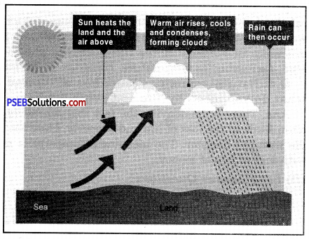
Due to lot of heat, air pressure reduces to a great extent. When the land warms up, it heats the air above it.
This causes the air to expand and rise. As the air rises, it cools and condenses. If this process continues then rain falls. This type of rainfall is very common in tropical areas. Such rainfall does not last for a very long time because due to less air pressure, rising air is unable to take much of the moisture with it.
2. Orographic Rainfall.
Such rainfall is produced when moist air is lifted as it moves over a mountain range. As the air rises and cools, orographic clouds form and serve as the source of precipitation, most of which falls up wind of the mountain ridge.
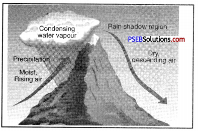
Some also falls a short distance downwind of the ridge and is sometimes called spillover. Such rainfall occurs only in mountains.
3. Cyclonic Rainfall.
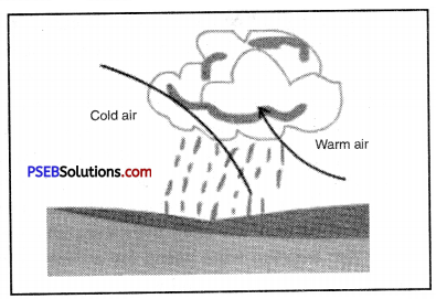
Cyclonic or Frontal rain occurs when two air masses meet and form a ‘front’. The warmer, moisture-laden air rises over the colder air as a ‘warm front’. As the air rises it cools, and its relative humidity increases, clouds form as water vapour condenses, and then there is fall of rain. During winters, north and north-west India receives rainfall because cyclones occur in the Mediterranean sea and comes toward India such rainfall is quite useful for the crops of Punjab.
Question 3.
Name the instruments used for collecting information about various aspects of climate, write in short about all of them?
Answer:
Many instruments are used for collecting information about various aspects of climate and these are given below :
1. Maximum and minimum thermometer. Such a thermometer is used to know about the temperature of a place. If we want to know about the climate of a place, we must know about its temperature. It consists of a U-shaped glass tube with two separate temperature scales set along each arm of the U. One of these is for recording the maximum temperature encountered and the other for the minimum temperature. The arms of the U-shaped tube terminate in sealed glass bulbs. Temperature is measured in centimetre grade or degrees of Fahrenheit.
2. Aniriod Barometer. Aniriod Barometer is a scientific instrument used in meteorology to measure atmospheric pressure. Instead of having a pool of mercury that the atmosphere pushes down or, they have a sealed, air-tight metal box inside. As the air pressure rises or falls, the box either squashes inward a tiny bit or flaxes outward. A spring is cunningly attached to the box and as the box moves in and out in response to the changes in air pressure, the spring expands or contracts and moves the pointer on the dial. The dial is marked with numbers, so you can read the air pressure instantly.
3. Dry and wet bulb thermometer. It is an instrument used to measure the relative humidity of the atmosphere. It consists of a thermometer with a bulb that is wet or moist and one that is kept dry. The relative humidity is calculated from the difference in readings of the thermometers when water evaporated from the wet bulb decreasing its temperature. Humidity in the air is always given in percentage.
4. Rain Gauge. Rain Gauge is used to measure rainfall and the amount of liquid precipitation over a set period of time. Basically it looks like a transparent cylinder with markings. You can read the amount of rainfall in inches or millimetres. It consists of a collector funnel and mechanism to recieve and measure the collected water.
5. Anemometer. An anemometer is a device used for measuring the speed of wind and is also a common weather station instrument. It consists of four hemispherical cups mounted on horizontal arms, which are mounted on a vertical shift. The air flow pass the cups in any horizontal direction turns the shaft at a rate that is roughly proportional to the wind speed. So, counting the turns of the shaft over a set time peirod produces a value proportional to the average wind speed for a wide range of speeds.
6. Wind Wane. A wind wane is an instrument for showing the direction of the wind. A typical wind wane has a pointer in front and fins in back. When the wind is blowing, the wind wane points into the wind. Reading the wind wane is easy. Whichever direction the fin is pointing will indicate where the wind is coming from.
![]()
Question 4.
What bad effects do natural disasters bring to human lives? Explain.
Answer:
The bad effects of natural calamities is given below :
- Physical Loss. Natural calamity such as an earthquake can destroy buildings service sector. It can lead to breaking of dams which can further led to more destruction.
- Death. Earthquake, Tsunami etc. can lead to the death of thousands of people specially people living near the epicentre. Deaths occur more at the places where there is more density of population.
- Public Health. Thousands of people can be wounded along with broken bones and even the spread of epidemics.
- Problem in Water Supply. Breaking down of dams and even water supply system can lead to obstacles in water supply.
- Electricity and Communication. All the communication systems and electric system can get destroyed which can lead to the stand still of the national economy.
PSEB 9th Class Social Science Guide Climate Important Questions and Answers
Multiple Choice Questions :
Question 1.
Which of these seasons do not occur in south India.
(a) Summer
(b) Rainy
(c) Winter
(d) Autumn.
Answer:
(c) Winter.
Question 2.
Cyclonic Rainfall in West Bengal is known as
(a) Kal Baisakhi
(b) Monsoon
(c) Loo
(d) Tsunami.
Answer:
(a) Kal Baisakhi.
Question 3.
Hot and dry wind blowing in north India during summer is known as
(a) Tsunami
(b) Monsoon
(c) Kal Baisakhi
(d) Loo.
Answer:
(d) Loo.
Question 4.
____________ is the most affected area by the Bay of Bengal branch of south-west monsoon.
(a) Chennai
(b) Amritsar
(c) Mawsynram
(d) Shimla.
Answer:
(c) Mawsynram.
Question 5.
____________is majorly affected by the retreating monsoon.
(a) Chennai
(b) Shimla
(c) Delhi
(d) Amritsar.
Answer:
(a) Chennai.
Question 6.
____________ and are two months mostly affected by rain in the whole India.
(a) June, July
(b) July, August
(c) August, September
(d) June, August.
Answer:
(b) July, August.
![]()
Question 7.
When did Tsunami come?
(a) 26 Dec. 2004
(b) 26 Dec. 2006
(c) 25 Nov. 2003
(d) 25 Nov. 2002.
Answer:
(a) 26 Dec. 2004.
Question 8.
____________ is used to know about the air pressure.
(a) Rain Gauge
(b) Aniriod Barometer
(c) Wind wane
(d) Anemometer.
Answer:
(b) Aniriod Barometer
Fill in the blanks :
Question 1.
Most of the rainfall (75-90%) in India occur during the months from June to
Answer:
September
Question 2.
Rainfall coming with western disturbances is useful for crops.
Answer:
Rabi
Question 3.
Mango shower is useful for the crop of
Answer:
Flowers
Question 4.
____________ coast gets winter rainfall in India.
Answer:
Coromandal
Question 5.
____________ climate is there in the coastal regions of India.
Answer:
Moist
![]()
Question 6.
____________ is used to measure moisure moisture in air.
Answer:
Dry and wet bulb thermometer
Question 7.
Around people died in many Indian state due to Tsunami.
Answer:
10,500.
True/False :
Question 1.
India has hot climate.
Answer:
True.
Question 2.
Indian climate is very much influenced by monsoon winds.
Answer:
True.
Question 3.
The distribution of rainfall is same in all the parts of India.
Answer:
False
Question 4.
There is a feature of Monsoon type of rainfall that there is no dry spell in it.
Answer:
False
Question 5.
Summer season in India is the lengthiest in all the seasons.
Answer:
True.
Question 6.
Temperature is measured with Aniroid Barometer.
Answer:
False
Question 7.
Wind speed is measured with Anemometer.
Answer:
True.
Very Short Answer Type Questions
Question 1.
Which land form of India acts as a powerful climatic divide?
Answer:
Himalaya mountain acts as a powerful climatic divide.
Question 2.
Which part of India gets rainfall due to western disturbances and for which crop is it useful?
Answer:
North India gets rainfall due to western disturbances and it is useful for rabi crop.
Question 3.
When India gets maximum rainfall?
Answer:
India gets maximum rainfall (75-90%) during the months from June to September.
Question 4.
Give one feature of retreating monsoon.
Answer:
At this time, low pressure area of monsoon becomes weak and it is replaced by high pressure area.
Question 5.
Name two branches of South-West monsoon in India.
Answer:
Arabian sea branch and Bay of Bengal branch.
![]()
Question 6.
Which part of India has maximum temperature in the beginning of summer season (March)?
Answer:
In the beginning of summer season, southern plateau has maximum temperature.
Question 7.
Which place gets maximum rainfall in the world?
Answer:
Mawsynram gets maximum rainfall in the world.
Question 8.
Which coast of India gets rainfall during winters?
Answer:
Coromandal Coast.
Question 9.
What type of climate does Indian coastal regions have?
Answer:
Equitable climate.
Question 10.
From which word, the word Monsoon originated?
Answer:
The word monsoon originated from the Arabian word Mausim.
Question 11.
What is the average rainfall in India?
Answer:
118 cm of rainfall.
Question 12.
In which part of India, temperature remains high throughout the year?
Answer:
Southern part of India.
Question 13.
What do we call to cyclonic rainfall in West Bengal?
Answer:
Kal Baisakhi.
![]()
Question 14.
What do we call to the local hot wind blowing in north India during summer season?
Answer:
It is called Loo.
Question 15.
Which hills get maximum rainfall in India?
Answer:
The Hills of Meghalaya.
Question 16.
What is the annual rainfall Mawsynram gets?
Answer:
1141 cm.
Question 17.
Name any two factors affecting climate of India?
Answer:
- Distance from equator
- Nearness to Indian ocean
- Air pressure system
- Land form.
Question 18.
Name two places each with minimum and maximum temperature during winter season.
Answer:
- Minimum Temperature-Amritsar and Leh
- Maximum Temperature-Mumbai and Chennai.
Question 19.
Name the coldest and hottest places in India during the summer season.
Answer:
- Coldest place-Leh, Shillong
- Hottest place-North-West plains of India.
Question 20.
What are Kal Baisakhi?
Answer:
The destructive cyclones are called Kal Baisakhi in West Bengal.
![]()
Question 21.
What is meant by Mango Shower?
Answer:
North-East Monsoon gives rain in coastal areas of Kerala and Karnataka at the end of summer season. It is called Mango Shower.
Question 22.
At which places do the Monsoon winds coming from Arabian sea and Bay of Bengal meet?
Answer:
The Monsoon winds from Arabian sea and Bay of Bengal meet in Punjab and Himachal Pradesh.
Question 23.
Name the types of rainfall.
Answer:
Three types – Convectional rainfall, Orographic rainfal and Cyclonic rainfall.
Question 24.
Why do Orographic rainfall fall continuously and for a long time?
Answer:
Monsoon winds continuously move from sea to land because of which orographic rainfall fall continuously and for a long time.
Question 25.
Which rainfall is good for the crops of Punjab?
Answer:
Cyclonic rainfall of winters is good for the crops of Punjab.
Question 26.
What is monsoon burst?
Answer:
When monsoon, all of a sudden, gives rainfall, it is called monsoon burst.
Question 27.
What do you mean by Loo?
Answer:
Loos are hot dusty winds caused by low pressure in hot season. These are very hot and are called Loo in local language.
Question 28.
Which instruments are used to check climate or weather?
Answer:
Maximum and minimum thermometer, Aniriod Barometer, Dry and wet bulb thermometer, Rain Gauge, Anemometer, Wind Wane etc.
![]()
Question 29.
Give major types of natural calamity.
Answer:
Natural calamity comes in different forms such as earthquake, tsunami, cyclone, flood, drought, volcanic eruption etc.
Question 30.
When and in which year did Tsunami come in Indian states?
Answer:
Tsunami came in December, 2004 in Andeman Nicobar, Coast of Tamil Nadu, Andhra Pradesh, Kerala etc.
Question 31.
What type of destruction was caused by Tsunami?
Answer:
It caused death of thousands of persons and damage of property as well.
Short Answer Type Questions
Question 1.
Name the traditional names according to Indian system of Seasons.
Answer:
|
S.No. Season |
Indian Traditional Names |
| 1. Winter Season | Mixture of Basant and winter |
| 2. Summer Season | Hot Season |
| 3. Rainy Seaspn | Rainy Season |
| 4. Season of retreating monsoons | Sharad Season |
Question 2.
Mumbai is colder than Nagpur. Why?
Answer:
Nagpur is situated away from sea. Whereas Mumbai is situated on the sea shore. There is equable type of climate in Mumbai due to effect of sea. Therefore there is less cold.
In the opposite of it, Nagpur is situated far away from sea and free from sea effect. Therefore, extreme type of climate is found here.
Therefore, Nagpur is colder than Mumbai in winter.
Question 3.
Most of the average Annual rainfall in India comes in just four months of the year.
Answer:
In India, rainfalls mostly from mid-June to mid-September. The Monsoon winds coming from sea blow over India in these four months. There vapour laden winds give heavy rainfall in India.
![]()
Question 4.
Mawsynram receives maximum rainfall in the world.
Answer:
Mawsynram is situated on southern part with of Garo and Khasi hills. It is situated at the head of a Funnel shaped hill. One branch of Monsoon winds of Bay of Bengal give rainfall here. Due to the strange position of these waves Mawsynram had become the place in world with highest rainfall.
Question 5.
Kolkata receives 145 cm of rainfall where as Jaisalmer receives only 12 cm of rainfall by the South West monsoon.
Answer:
The S. W. Monsoons, from Bay of Bengal, first of all strike in Kolkata in West Bengal. These moisture laden winds give a heavy rainfall of 145 cms here.
Jaisalmer lies to the west of Aravallis in Rajasthan. Aravallis lie parallel to S.W. Monsoons of Arabian sea. So these mountains fail to check S. W. monsoons. These winds move northward giving only 12 cms of rainfall.
Question 6.
Chennai receives most rainfall during winter season.
Answer:
Chennai is situated on Eastern coastal plain of India. It comes under the effect of North-East Monsoon winds. These winds move from land to sea. But while crossing the Bay of Bengal, these pick up moisture. After striking Eastern ghats, these give heavy rainfall in winter. In summer, it gets less rain as it is a rain shadow area.
Question 7.
What is the contribution of western Jet stream in bringing cyclonic rainfall?
Answer:
The west and central Asia remain under the influence of westerlies. A current of westerlies, known as jet stream blows north of the Himalayas, while its southern branch flows south of the Himalayas along 25° N latitude. This branch of jet stream helps in bringing the western disturbances to the Indian sub-continent during winter. These western disturbances originate in west Asia and near the Mediterranean Sea. The westerly jet travels eastwards and steers at least four or five such depressions in India during winter. These cause the needed rainfall on plains and snowfalls on Himalayas.
![]()
Question 8.
In spite of being close to the Arabian Sea, why does Rajasthan remain dry?
Answer:
The western part of Rajasthan is desert. It gets an annual rainfall less than 20 cms. This is due to the following reasons :
- Rajasthan is under the influence of S.W. Summer monsoons. The Aravallis system lies parallel to the direction of S.W. monsoons coming from Arabian Sea. So this mountain system is unable to check these winds. So western Rajasthan is practically dry. The southern part get some rainfall.
- This area lies at a great distance from the Bay of Bengal. The Bay of Bengal monsoons become dry and lose their moisture when they reach Rajasthan.
- This area is away from the Himalayan region. So it does not come under the influence of monsoons giving rain in Sub-Himalayan region.
Question 9.
How does Himalayas act as a ‘climatic divide’ for India?
Answer:
The Himalayas act as a mountain wall to protect the sub-continent from the northern winds. These cold chilly polar winds cannot enter India, as these cannot cross the lofty Himalayas. So these mountains enable Northern India to have a tropical climate. Thus the Himalayas act as an effective climatic divide.
Question 10.
Distinguish between Mango showers and Kal Baisakhi.
Answer:
Mango Showers. Local rainfall in coastal areas of Kerala and Karnataka at the close of summer premonsoons is called Mango showers. It helps in early ripening of mangoes.
Kal Baisakhi. In summer, West Bengal and Assam get sharp showers by evening thunder-storms. These are called Kal Baisakhi. It means calamity of the month of Baisakh.
Question 11.
Name three characteristics of retreating monsoons.
Answer:
The months of October and November are known for retreating monsoons,
- The monsoon low pressure trough becomes weaker and is replaced by high pressure.
- The effect of monsoons over Indian landmass begins to shrink.
- The direction of surface winds starts reversing.
Question 12.
Why does the Pre-Monsoonal rainfall occur?
Answer:
In summer, equatorial low pressure shifts towards Tropic of Cancer. To fill this space, the S.E. trades cross the Equator and get a direction of S.W. winds due to rotation of the earth. On 1st June, when these winds reach west coast, moderate rainfall occurs on windward slope of west ghats. This is called pre-monsoonal rainfall.
![]()
Question 13.
Which elements affect the climate of India?
Answer:
The climate of India is mainly based on the following facts :
- Distance from the equator. The places which are situated near the equator have high temperature whereas the places away from the equator do not have high temperature.
- Height above sea level. The higher you go, the cooler it is. That is why the mountainous regions are cooler than plains.
- Distance from the sea. The places near the sea have an equable climate. Neither the summers are very hot nor the winters are cold, whereas in the parts away from the sea the summers are hot and winters are cold.
- Winds. The winds have a great affect on the climate of India. The winds coming from the sea are full of moisture and they cause heavy rain. On the other hand, the winds that come from the land are dry winds and cause no rain.
Question 14.
Give main features of Monsoon rainfall.
Answer:
- Uncertain rainfall. Summer rainfall is quite uncertain. Sometimes monsoons start early resulting in floods. Often the onset of monsoons is delayed resulting in drought. The early or late retreat of monsoons also results in serious droughts.
- Unequal distribution. The rainfall is unevenly distributed over the country. About 10% of the country gets more than 200 cms of rain while 25% of the country gets less than 75 cms of rain.
- Heavy rainfall. Indian rainfall is heavy and downpouring type. It is often said, “It pours, it never rains in India”.
- Relief rainfall. The amount of rainfall is determined by the presence of mountains. High mountains force monsoons to rise and or rain.
Question 15.
Write a note on winter season.
Answer:
The cold season lasts from December to February. The sun is over head at Tropic of Capricorn. The Indian sub-continent has winter season. January is the coldest month. The southern parts have warm conditions. (20°C) while low temperatures (10°C) are found in N.W. India.
High pressure is developed over N.W. part while a low pressure exists over Indian Ocean with the result winds blow from land to sea. The out-blowing winds are Westerly in Northern plain and North Easterly over the rest of the country.
The N.E. Monsoons are off-shore winds and are dry. But these winds pick up some moisture crossing Bay of Bengal and give rain to S.E. coast of India. Some cyclones from the Mediterranean Sea also bring a small amount of rain (10 to 20 cms.) to Northern plains. Night Frost is common in the N.W. parts.
![]()
Question 16.
Write a note on the Summer Season.
Answer:
The hot season lasts from March to May. As the sun’s rays fall vertical over ‘Tropic of Cancer, the temperature begins to rise’. The average temperature is above 30°C; the maximum temperature rises to 50°C in Barmer (Rajasthan). The daily range of temperature rises in inland areas. Intense heat results in the development of low pressure over N.W. India and Pakistan. A high pressure exists over Indian Ocean. S.W. Monsoons “begin to blow from sea to land. ‘Norwesters’ and ‘Loo’ blow over Northern plains. Some areas receive convectional rainfall. The west coast also starts receiving rainfall. Most of the country is dry in the pre-Monsoon period.
Question 17.
Why and how is Maximum and Minimum Thermometer used?
Answer:
Such a thermometer is used to know about the temperature of a place. If we want to know about the climate of a place, we must know about its temperature. It consists of a U shaped glass tube with two separate temperature scales set along each arm of U. One of these is for recording the maximum temperature encountered and the other join the maximum temperature. The arms of the U-shaped tube terminate in sealed glass bulb. Temperature is measured in centimetre grade or degrees of Fahrenheit.
Question 18.
Write a note on Aniriod Barometer.
Answer:
Aniriod Barometer is a scientific instrument used in meteorology to measure atmospheric pressure. Instead of having a pool of mercury that the atmosphere is down on, they have a sealed, air-tight metal box inside the air pressure rises or falls, the box either squashes inward a tiny bit or flexes outward. A spring is cunningly attached to the box and as the box moves in and out it response to the changes in air pressure, the spring expands or contracts and moves the pointer on the dial. The dial is marked with numbers so you can read the air pressure instantly.
Question 19.
Write a note on Rain Gauge.
Answer:
Rain Gauge is used to meausre rainfall and the amount of liquid precipitation over a set period time. Basically, it looks like a transparent cylinder with markings. You can read the amount of rainfall in inches or millimetres. It consists of a collector funnel and mechanism to recive and measure the collected water.
Question 20.
Give a brief description of Tsunami.
Answer:
Tsunami is a Japanese word which means a high sea wave. If Tsunami comes at a place, very high sea waves occur at that place. Their height goes upto 10 metre to 50 metre at sea shore. Their speed is quite high. In an open sea, they move at the speed of 400 km-1000 km per hour. Actually if earthquake comes under sea bed, it causes Tsunami. On 26 December, 2004, Tsunami came in South-East Asia which caused a great destruction. Around 10,500 people died in India and it caused a lost of? 10,000 crore to many Indian states.
Long Answer Type Questions
Question 1.
What are the regional variations in the climate of India?
Answer:
1. Range of Temperature. There is a great variation in range of temperatures in different parts of India. Kerala and Andaman-Nicobar islands have a daily range of temperature i. e. 8° C. On the other hand in Thar Desert, if the day temperature is around 50° C, at night it may drop down very close to freezing point (0°C). The daily range of temperature is 50°C.
2. Direction of Rain Bearing Winds. Most of India gets rain in summer from S. W. Monsoons but, in winter Tamilnadu gets rain from N. E. Monsoons.
3. Form of Precipitation. Most of the country gets rain showers, while snowfall occurs in the Himalayas.
4. Amount of Rainfall. The annual rainfall is less than 10 cms in N. W. Himalayas and the Thar Desert, it exceeds 400 cms. in Meghalaya. Mawsynram gets 1,141 cms Rainfall.
5. Rainfall Regime i.e. Seasonal Distribution of Rainfall. There is a great variation in rainfall regimes in the country. Most of the country gets rain from advancing monsoons in summer. Tamilnadu gets rainfall in winter from N.E. monsoons. Some parts receive rainfall from retreating monsoons.
Question 2.
Give an account of the main reasons for the climatic variations in the country.
Answer:
There are great variations in the climate of India. It is not the same throughout the year due to:
- Northern hilly region remains cold due to high altitude. Coastal areas have an equable climates. Interior areas have high temperatures.
- Windward slopes get high rainfall but rain shadow areas are dry.
- In summer, wind blow from sea to land. These moist winds give heavy rainfall. But as these move ahead, the rainfall goes on decreasing.
- In winter the winds blow from land to sea. These winds are dry. Only S.E. coast of India gets rainfall. Other parts remain dry.
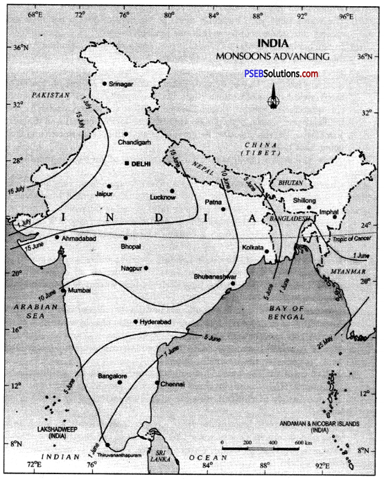
Monsoons Advancing Season
![]()
Question 3.
Describe India’s rainy season in India.
Answer:
Rainy season is also called the South West Monsoon season. Its time period is from the June to mid September. The main characteristics of this season are :
- A low pressure trough is developed in north-west India.
- Winds enter into the country from sea and give heavy rainfall.
- The winds filled with humidity move at the rate of 30 km per hour and spread into whole country within one month.
- Indian peninsula divides Monsoon into two parts—Monsoon winds of Arabian Sea and Monsoon winds of Bay of Bengal.
- Most of rainfall in Western ghat and North East area of India is done by monsoon winds of Bay of Bengal. There is more than 250 cm of rainfall on the winward slopes of western ghats. On the opposite, there is more than 50 cm of rainfall on leeward slopes. Therefore, due to the reason most of rainfall in Northeast states of India is highest and longer on hills of Eastern Himalayas. On the opposite the amount of rainfall goes on decreasing from going East to West.
Question 4.
Give the main characteristics and effects of monsoon rainfall in India.
Answer:
Characteristics of rainfall in India : The average annual rainfall in India is about 110 cms. It is estimated that more than 85% of this rainfall is received in summer. The main characteristics of summer rainfall are as follows :
- Monsoonal rainfall. Most of the rain is received from S.W. summer monsoons during the period mid-June to mid-September. It is seasonal rainfall.
- Uncertain rainfall. Summer rainfall is quite uncertain. Some times monsoons start early resulting in floods. Often the on set of monsoons is delayed resulting in drought. The early or late retreat of monsoons also results in serious droughts.
- Unequal distribution. The rainfall is unevenly distributed over the country. About 10% of the country gets more than 200 cms of rain while 25% of the country gets less than 75 cms of rain.
- Heavy rainfall. Indian rainfall is heavy and downpouring type. It is often said, “It pours, it never rains in India”.
- Relief rainfall. The amount of rainfall is determined by the presence of mountains. High mountains force monsoons to rise and or give rain.
- No continuity of rainfall. Summer rain is characterised by breaks or dry spells.
- Variable rainfall. Most of the areas have variable rainfall, as much as 30 cms. plus or minus. Due to variability in areas of low rain, famines result.
Question 5.
Tnspite of great monsoon unity in India, there exist many regional variations.’ Explain the statement.
Answer:
There is a monsoonal unity in India but the rainfall is not uniform in India. Some areas get very high rainfall while others get low; rainfall due to different reasons.
- Location. Wind ward slopes get high rainfall. But leeward slopes are in rain shadow and are dry. N.E. plains, Himachal Pradesh and coastal region gets heavy rainfall. But most of Peninsular India gets low rainfall.
- Direction of mountains. When the mountains face the on shore winds, they provide heavy rainfall. But when mountains lie parallel to direction of monsoons, these fail to check winds and do not give rainfall. Rajasthan is a desert due to this reason.
- Direction of winds. Places where monsoons strike first, get heavy rainfall like Kolkata. But other places like Varanasi get low rainfall.
- Distance from the sea. Places near the sea get heavy rainfall. But inland areas remain dry.
![]()
Question 6.
Describe the distribution of rainfal in India.
Answer:
Distribution of rainfall: The average annual rainfall of India is 115 cms. Regional variations in the distribution are found due to differences in the relief of the country. Rainfall is unevenly distributed throughout the country.
India can be divided into the following rainfall regions :
- Areas of Heavy Rainfall. These areas get more than 200 cms. of annual rainfall. These include the Western Coast and the Western Ghats, Sub-Himalayas, and the N.E. parts of India.
- Areas of Moderate Rainfall. These areas get annual rainfall of 100-200 cms. These include West Bengal, Orissa, Bihar, Eastern parts of U.P. and Madhya Pradesh and coastal plains of Tamilnadu.
- Areas of Low Rainfall. These areas experience an annual rainfall of 50-100 cms. These include the western past of U.P., Haryana, Punjab, Gujarat, Peninsular plateau and Eastern Rajasthan.
- Areas of Scanty Rainfall. These areas get less than 50 cms. of annual rainfall. These include Ladakh, S.W. Punjab, Southern Haryana, Western Rajasthan, Kutch and Thar Desert.