Punjab State Board PSEB 9th Class Social Science Book Solutions Geography Chapter 2a India: Physiographic Units Textbook Exercise Questions and Answers.
PSEB Solutions for Class 9 Social Science Geography Chapter 2a India: Physiographic Units
SST Guide for Class 9 PSEB India: Physiographic Units Textbook Questions and Answers
Map Work:
Show on the outline map of India :
(i) Karakoram, Pir Pajal, Shiwalik, Satpura, Patkai Bam, Khasi and Garo mountain Ranges.
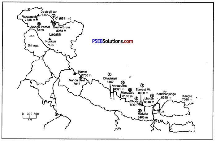
(ii) The mountain Peaks of Kanchanjunga, Godwin-Austin, Dhaulagiri, Guru Shikhar and Anai Mudi.
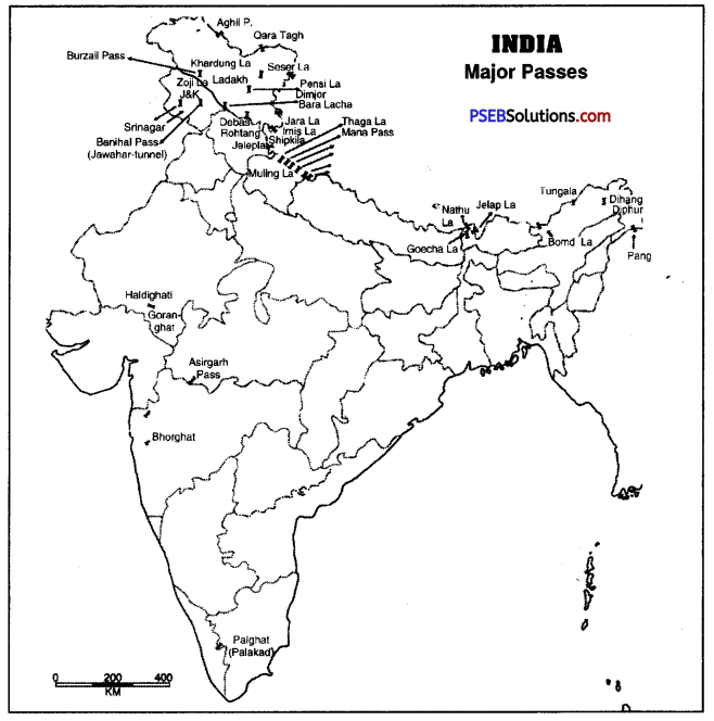
(iii) Any five passes and three plateau regions.
Answer:
Do it yourself with the help of India Map.
Objective Type Questions:
Answer the following questions in a single word to one sentence length :
Question 1.
Name any two physiographic region of India.
Answer:
On the basis of physiography, India can be divided in five parts :
- Himalaya Mountain,
- Northern Plains,
- Peninsular Plateau,
- Coastal Plains,
- Indian Islands.
Question 2.
If you visit Guru Shikhar, in which mountain range you shall be there?
Answer:
Mount Abu (Aravali Mountain).
Question 3.
What is the length and breadth of Northern Plains of India?
Answer:
The length of northern plains is 2400 km and breadth is 150-300 km.
Question 4.
In how many categories the India archlipelogos are divided in?
Answer:
Indian islands are mainly divided in two parts- Andaman-Nicobar islands and Lakshdweep islands.
Question 5.
Which of following is not a part of plains?
(i) Bhabar
(ii) Bhangar
(iii) Khayal
(iv) Kallar.
Answer:
(iii) Khayal.
Question 6.
Which among the following is not a lake?
(i) Saddle
(ii) Sambar
(iii) Chilka
(iv) Vembanand.
Answer:
(i) Saddle.
![]()
Question 7.
Which of the following is odd?
(i) Sharda
(ii) Kaveri
(iii) Gomati
(iv) Yamuna.
Answer:
(ii) Kaveri.
Question 8.
Which of the followinis not a range of Himalayas?
(i) Rakashposhi
(ii) Dafla
(iii) Zaskar
(iv) Nilgiri.
Answer:
(iv) Nilgiri.
Short Answer Questions :
Give short answers for the following Questions :
Question 1.
Write a note on the formation of a Himalaya.
Answer:
Millions of years ago, the Himalayas were occupied by a geosyncline known as Tethys. It was sandwiched between two long and large landmasses—Angara land on the north and Gondwana land on the south. The Tethys sea stretched over the Northern plains in east-west direction. For millions of years, sediments were deposited in Tethys sea. These sediments were folded to form the Himalayas. The landmasses of Angara land and Gondwana land drifted slowly towards each other. The horizontal forces worked from two opposite directions resulting in compression. It led to sinking of the ‘Tethys Sea”.
The Indian plate was driven northwards and pushed beneath the Eurasian plate. When the two plates came closer, the Tethys sea’s crust fractured. The sediments buckled and folded to form the mighty fold mountains of the Himalayas. It has been observed that the “Himalayas are still rising”.
Question 2.
Describe the Khadar plains. How are they different from the Bet areas?
Answer:
Khadar is a plain made up with new alluvial soil. This plain is made up of deposition of sediments of Himalayan rivers which spread over the region. This soil is quite fertile. Such plains with same soil are called Bet in Punjab. So, Bet is the local name of plains with Khadar soil.
![]()
Question 3.
Write a note on the Central Himalayas.
Answer:
- Lesser Himalaya is also known as Himachal or Central Himalaya. Its average height is 3500′ metres to 5000 metres and breadth of the mountains of this range is 60-80 km.
- Ranges. This part of Himalaya has many ranges such as Pir Panjal and Naga Tibha in J&K, Dhauladhar and Kumaon in Himachal, Mahabharat in Nepal, Kumaon and Mussoorie in Uttrakhand and Thimpu in Bhutan.
- This region of Himalaya has many beautiful places where people come and enjoy for sometime such as Shimla, Srinagar, Mussoore, Nainital, Darjeeling etc.
Question 4.
What is the difference between Eastern and Western Ghats?
Answer:
|
Western Ghats |
Eastern Ghats |
| 1. The Western ghats form a continuous chain from Gulf of Cambay to Kanyakumari. | 1. The Eastern ghats form a discontinuous chain of low hills from Orissa to Coromandel coast. |
| 2. These consist of Sahyadri, Nilgiris, Annamalai and Cardamom hills. | 2. The Eastern ghats are known by local names. |
| 3. The main passes in Western ghats are: Thai ghat, Bhor ghat and Pal ghat. | 3. There are wide gaps in Eastern ghats, through which rivers flow. |
| 4. The average height of Western ghats is 1000 metres. The highest peak is Anaimudi (2965 metres) in Kerala. | 4. The average height of Eastern ghats is 450 metres. These merge with western ghats in Nilgiris. |
Question 5.
Describe the Indian Archipelagos and write the names of the Islands.
Answer:
There are 267 Indian islands and they can be divided in two parts :
1. Andaman & Nicobar islands. These islands form two major groups in Bay of Bengal. These are Andamans and Nicobar islands. These islands extend between 6° and 14° N latitudes for a distance of 600 kms. These islands are 214 in number. The Nicobar group consists of 15 islands extending between 6° N to 10° N latitudes. Ten-degree channel separates the Andaman group of islands from the Nicobar group. These islands form a union territory of India with Port Blair as its capital. Indira Point in the Nicobar islands is the southernmost point of the Indian Union. These islands form the summits of the submerged hills of the ocean floor.
2. Lakshadweep islands. These islands are situated in the Arabian Sea and lie 320 km off the coast of Kerala between 8° and 12° North latitudes. These are coral islands.
Question 6.
Differentiate between Bhabar and Terai.
Answer:
|
Terai |
Bhabar |
| 1. Terai is a broad long zone south of Bhabar plain. | 1. Bhabar is a long, narrow plain along the foothills. |
| 2. It is a marshy damp area covered with thick forests. | 2. It is a pebble studded zone of porous beds. |
| 3. It is 20-30 kms. wide. | 3. It is 8-16 kms. wide. |
| 4. Many streams re-emerge here from the Bhabar area. | 4. Streams are lost in the region due to porous rocks. |
| 5. It is suitable for agriculture. | 5. It is unsuitable for agriculture. |
Long Answer Questions:
Answer the following questions in detail :
Question 1.
Explain in detail mountain ranges of peninsular plateau.
Answer:
The Deccan Plateau is the oldest structure of India. It is the core of the geology of India. It is surrounded by oceans on three sides. Therefore it is often called Peninsular plateau. It covers an area of about 16 lakh sq. km. The average altitude of the’plateau varies from 600 to 900 metres. Its limits are formed by the Aravallis in the North, Rajmahal Hills and Shillong plateau in the East. The southernmost point is known as Kanyakumari. It is an ancient, stable, hard block formed by Igneous and Metamorphic rocks. It was a part of Gondwana land.
Division of Peninsular Plateau. A series of low hills, known as Satpura ranges between 21° N to 24° N latitudes divides the Peninsular plateau into two parts :
(a) Malwa Plateau
(b) Deccan Plateau
(a) Malwa Plateau. The Malwa plateau covers a large part of central highlands. It extends from Aravallis in the West to Ganges valley in the North and East, and Vindhyas in the South. The Aravallis are residual mountains or Relict Mountains. Its highest peaks sire Mt. Abu (1158 metres) and Guru Shikhar (1722 metres). This plateau includes Bundelkhand, Baghelkhandand, Chambal valley. The Vindhyan plateau consists of long, narrow ridges made up of quartzite rocks. It extends upto Mahadeo Hills, Kaimur range, Maikal range, Rajmahal hills in the East. In the East lies Chotta Nagpur plateau drained by Damodar river. This plateau is the storehouse of minerals of India.
(b) Deccan Plateau. This plateau lies South of Narmada river. It is surrounded by mountain ranges on three sides-Western Ghats, Eastern Ghats and Satpuras. Narmada and Tapti valleys are rift valleys between Satpuras and Vindhyas. Karnataka Plateau lies between Eastern Ghats and Western Ghats. Deccan plateau is a tilted plateau with a general eastward slope. It covers an area of about 70 lakh sq. km. Its average height varies between 500 metres to 1000 metres. The rivers have divided this plateau into many sub-divisions.
N. W. Deccan plateau is made up of lava and is known as Deccan trap.
1. Western Ghats. Western Ghats extend from Tapti valley up to Kanyakumari for about 1500 kms. It has three passes-Thal ghat, Bhor ghat and Pal ghat. These ranges rise abruptly from the coast. Short swift streams flow towards the west and do not form deltas. The average height is about 1200 metres. Godavari, Krishna and Cauvery rivers rise from Western ghats and flow towards East.
2. Eastern Ghats. Eastern Ghats extend for about 800 kms from Mahanadi valleys upto Nilgiris. These are not continuous ranges. Rivers form wide gaps. Javadi, Shevroy and Nallamalai hills are found in the Southern part.
3. Nilgiris. Western ghats and Eastern ghats join together to form a knot known as Nilgiris. Anai Mudi (2698 metres) is the highest peak. Anaimalai, Palni, and Cardamom Hills are found in the southern part.
![]()
Question 2.
Describe the formation of Ganga-Brahmputra plains and write their regional distribution.
Answer:
Northern Plain of India :
This great plain extends in between the Himalayas and the Peninsular plateau extending from Punjab Plains to Assam Valley. It is 2400 km. long and 240 to 320 km wide. Its average height is 150 metres. It covers an area of 7.5 lakh sq. km.
It is an alluvium filled trough. It has been formed by the deposition of sediments brought from the Himalayas by the Ganga, Sutlej and by the. rivers of the peninsular plateau. Therefore it is called an alluvial plain. It is a dead flat lowland. The maximum height is 283 metres near Ambala. It has fertile alluvial soils of Khadar and Bangar. It is agriculturally a very productive part of India.
Division of Northern Plain :
- Bhabar and Terai. It is a long, narrow zone along the foothills. It is a pebble studded zone. Swampy areas occur in Terai.
- Punjab Plain. This plain has a slope in the South-West direction. It has been formed by the deposition of sediments by Ravi, Beas and Sutlej rivers. Chos (Seasonal streams) cause soil erosion in the foothills of Shivalik.
- Ganga Plain. This plain has been formed by the deposition of sediments brought by the Ganga and its tributaries. It can be divided into three regions :
(1) upper Ganga plain,
(2) middle Ganga plain and
(3) the lower Ganga plain. It occupies an area of about 3.5 lakh sq. km. Sunderban Delta is formed in the lower Ganga plain. This fertile delta is the largest delta of the world. - Brahmaputra Plain. This plain is situated in the eastern part and is often known as Assam valley. The Brahmaputra river forms a large delta in Bangladesh. The river forms a narrow, deep gorge called ‘Dihang gorge’ which is 12,000 metres deep.
Question 3.
Describe the Indian Coastal Plains.
Answer:
Coastal plains are spread along with Arabian Sea and Bay of Bengal. They can be divided in two parts-Western coastal plains and Eastern coastal plains.
|
Western Coastal Plain |
Eastern Coastal Plain |
| 1. West Coast is a narrow alluvial plain with a width of 50-80 kms. It is uneven and wet. | 1. The Eastern Coast has a wide plain with well developed delta 80 to 120 km. wide. It is level and dry. |
| 2. Beautiful lagoons are found on the Malabar Coast. | 2. The Eastern Coast has only two or three lagoons. |
| 3. The short swift rivers do not make any deltas on the Western Coast. The Tapti and Narmada make estuaries. | 3. The large rivers make wide deltas on the Eastern Coast. Mahanadi, Godavari, Krishna, Cauvery make well-developed deltas. |
| 4. Kandla, Mumbai, Marmagao, Mangalore and Cochin are major ports on West’coast. | 4. Tuticorin, Chennai, Vishakhapatnam, Paradeep and Kolkata are major ports on the East coast. |
| 5. Western Coastal plains receive rainfall in summer season due to advancing monsoon winds. | 5. Many of the Eastern coastal plain areas recieve winter rainfall due to retreating monsoon winds. |
Question 4.
Differentiate between the advantages of Himalayan mountains and Peninsular plateau.
Answer:
Himalaya mountain and Deccan plateau are the twq important physiographic divisions of India. Both these make India prosperous in their own way. Their comparison of advantages is given below :
Advantages of Himalaya Mountain :
- Rainfall: The monsoon winds coming from the Indian ocean get struck with Himalaya and give lot of rainfall to the region. They also give rainfall to the northern plains.
- Many rivers: Almost all the rivers flowing in northern India originate in Himalaya mountain such as Ganga, Yamuna, Sutlej, Brahmaputra. These are perennial rivers and the melting snow of Himalaya gives water to such rivers.
- Fruit and Tea: The slopes of Himalaya are quite productive for producing tea and different types of fruit.
- Useful Wood. Dense forests are there on Himalaya. These forests are our wealth. Wood obtained from these forests is quite useful for us and many industries are dependent upon them. This wood is also used for construction of houses as well.
- Good grasslands: Many green grasslands are available on Himalayas. Many tribal communities rear animals on such grasslands.
- Places of entertainment: There are many beautiful valleys in the Himalayan region. Kashmir valley is such beautiful valley which was known as heaven on earth. The valleys of Kullu and Kangra in Himachal Pradesh and Kumaon in Uttrakhand are other major valleys of this region. People often visit such places to relax.
Advantages of Deccan Plateau :
- Deccan plateau is rich in mineral resources. 98% of the country’s mineral wealth is available in the region. Coal, iron, manganese etc. many minerals are available in this region.
- Its soil is quite useful for the growth of cotton, tea, rubber, sugarcane, coffee, spices etc.
- Its rivers form many waterfalls which are quite useful for the production of hydroelectricity.
- This region is quite famous for the forests of saal, sagvan, chandan etc.
PSEB 9th Class Social Science Guide India: Physiographic Units Important Questions and Answers
Multiple Choice Questions:
Question 1.
The height of Mount Everest is
(a) 9848 m.
(b) 7048 m.
(c) 8848 m.
(d) 6848 m.
Answer:
(c) 8848 m.
Question 2.
Jog waterfall is on:
(a) Ganga river
(b) Sharavathi river
(c) Yamuna river
(d) Chenab river.
Answer:
(b) Sharavathi river.
Question 3.
Most of the part of Himalaya is spread in:
(a) India
(b) Nepal
(c) Tibet
(d) Bhutan.
Answer:
(c) Tibet.
Question 4.
Himalaya mountain originated from:
(a) Tethys sea
(b) Pacific Ocean
(c) Indian Ocean
(d) Bay of Bengal.
Answer:
(a) Tethys sea.
![]()
Question 5.
The part between Ravi and Reas rivers is known as:
(a) Bist Doab
(b) Peninsular Plateau
(c) Chaj Doab
(d) Malabar Doab.
Answer:
(a) Bist Doab.
Question 6.
Konkan plain is spread
(a) From Daman to Goa
(b) From Mumbai to Goa
(c) From Daman to Bengaluru
(d) From Mumbai to Daman.
Answer:
(a) From Daman to Goa.
Question 7.
Major peak of Western Ghats is :
(a) Guru Shikhar
(b) Vabulamals
(c) Konkan Shikhar
(d) Mount Kg.
Answer:
(a) Guru Shikhar.
Question 8.
The plain made by Sutlej, Brahmaputra and Ganga river system is known as:
(a) Southern plain
(b) Eastern plain
(c) Northern plain
(d) Tibetan plain.
Answer:
(c) Northern plain.
Fill in the blanks:
Question 1.
The average height of Trans Himalaya is ________ metres.
Answer:
6000
Question 2.
________ is the highest peak of the world.
Answer:
Mount Everest
Question 3.
The end point of Indian peninsular plateau is ________
Answer:
Kanyakumari
Question 4.
Thai ghat, Bhor ghat and ________ are the passes of western ghats.
Answer:
Pal Ghat
![]()
Question 5.
Chilka lake is India’s largest ________ lake.
Answer:
saline
Question 6.
________ river becomes a boundary between two parts of a great plateau.
Answer:
Narmada
Question 7.
________ Himalaya is the longest and highest range of India.
Answer:
Great
Question 8.
Malabar coast is spread from Goa to ________
Answer:
Mangalore
Question 9.
The plain of Chhattisgarh is made by ________ river.
Answer:
Mahanadi.
True/False:
Question 1.
Trans Himalaya is also known as Tibetan Himalaya.
Answer:
True
Question 2.
Most of the places of entertainment of Himalaya are situated in Great Himalaya.
Answer:
False
Question 3.
Kaveri and Krishna played a very important role in the formation of northern plains.
Answer:
False
![]()
Question 4.
There are 3 passes in western ghats: Thai Ghat, Bhor Ghat and Pal Ghat.
Answer:
True.
Question 5.
Western Ghats are also knwon as Suhadris.
Answer:
True.
Very Short Answer Type Questions
Question 1.
What is the size of the Himalayan Mountain range?
Answer:
Himalayas are a convex curve. Its central part is bent along Indo-Nepalese border and looks like a bow.
Question 2.
How did Himalayan mountain regions originate?
Answer:
Himalayas have arisen out of Tethys sea.
Question 3.
Name the major peaks of Trans Himalayas.
Answer:
The main peaks are Mount Kg, Godwin Austin, Hindon Peak, Broad Peak Geyserabam, Rakaposhi, Harmush.
Question 4.
Which mountain peaks are found at the height above 8000 metres in Greater Himalayas?
Answer:
Mount Everest (8848 metres),Kanchenjunga (8598 metres), Makalu (8481 metres), Dhaulagiri (8172 metres), Manalasu, Naga Parbat and Annapurna.
![]()
Question 5.
Name the young and old moutains of India.
Answer:
Himalayas are young mountains. Old mountains include Aravallis, Vindhyas, Satpuras.
Question 6.
Where are rift valleys located in India?
Answer:
Rift valleys are found over peninsular India like Narmada and Tapti valleys.
Question 7.
What is meant by delta?
Answer:
A triangular shaped land formed in the lower course of a river is called a delta.
Question 8.
Name some important deltaic regions of India.
Answer:
The main deltas are: Ganga Brahmaputra, Godawari Delta, Kaveri Delta, Krishna Delta and Mahandi Delta.
Question 9.
Which passes are found in the Himalayan Mountains?
Answer:
The main passes in Himalayas are Burzel, Zojila, Nanak La, Chang La, Khurnak La, Baralg., Shipki La, Nathula, Takla Kot.
Question 10.
Name the important mountain ranges of lesser Himalayas.
Answer:
- Pir Panjal in Kashmir
- Dhauladhar to Kumaon in H.P.
- Mahabharat ranges in Nepal
- Mussorie in U.P.
- Thimpu in Bhutan.
Question 11.
Which hill stations and valleys are found in Lesser Himalayas?
Answer:
Shimla, Dun, Path Doon, Kothri Doon, Udhampur, Kotli.
![]()
Question 12.
Name the main Doon valleys of our country.
Answer:
Dehra Dun, Patli Doon, Kothri Doon, Udhampur, Kotli.
Question 13.
Name the major Eastern off-shoots of Himalayas.
Answer:
Patkoi Bum, Garo, Khasi, Jaintia, Tripura. .
Question 14.
Which landform features formed by rivers are found in the Great Northern plains?
Answer:
Alluvial cones, Fans, Meanders, River terraces, Natural leaves and Flood plains.
Question 15.
Which inter-fluves are formed in the North-Western Plains?
Answer:
- Bari Doab (Majha),
- Bist Doab (Doaba),
- Malwa,
- Haryana Plains.
Question 16.
What is the size of the Brahmaputra plain?
Answer:
Brahamputra plain is 640 km long and 90-100 km wide. This narrow plain slopes from N.East to West.
Question 17.
What is the extent of Aravalli mountain range? Give the name of its highest peak.
Answer:
Aravallis extend from Delhi to Gujarat. It is 725 km long. Guru Shikhar 1722 metres high is the highest peak.
Question 18.
Name the major peaks of western ghats.
Answer:
- Vania Mala (2339 metres),
- Kudremukh (1849 metres),
- Pushpagiri (1714 metres),
- Kalsubai (1646 metres).
![]()
Question 19.
Name the southern mountains of the Eastern Ghats.
Answer:
Javadi, Gingee, Shevroy, Kalaimalais, Panchmalais, Godumalai are the hills of Eastern ghats.
Question 20.
Which hill stations are found in the Deccan plateau’s hilly region?
Answer:
Doda Beta, Ootacumand (Udagmandlam), Kodaikanal.
Question 21.
Name the Islands in the Arabian sea.
Answer:
This group of islands is called Lakshadweep. It includes Amini Divi, Central (Lacca deep), Minicoi in South.
Question 22.
Where is the Southern frontier point of India located?
Answer:
Indira Point (Near Great Nicobar).
Question 23.
Give any three uses of the coastal plains to the entire country.
Answer:
- Natural Bays and Ports are found.
- Many lagoons are found.
- It is a rich fishing ground.
Question 24.
Which river becomes a boundary between two large Indian plateaus?
Answer:
Narmada River.
Question 25.
Which are the Island groups of India and where are they situated?
Answer:
Andaman Nicobar and Lakshdweep are two Island groups and they are situated in Bay of Bengal and Arabian Sea respectively.
Question 26.
Which range of Himalaya is called Shiwalik?
Answer:
Outer Himalaya range.
Question 27.
Which rivers played an important role in the formation of Northern plains of India?
Answer:
Sutlej, Brahmaputra and Ganga river system.
Question 28.
What do you call the coastal region from Goa to Mangalore?
Answer:
Malabar Coast.
Question 29.
From where to where the Konkan coast is stretched?
Answer:
Konkan coast is stretched from Daman to Goa.
![]()
Question 30.
Which region of India is quite rich in mineral resources?
Answer:
Peninsular Plateau.
Short Answer Type Questions
Question 1.
Give any two proofs of Himalayas’ successive upliftment.
Answer:
Himalayas were formed about 400 lakh years ago in the Tethys sea. Rivers continued depositing sediments in the Tethys sea between the Tibet and Indian Plateau. Both the plates—Eurasian and Indian—drifted towards each other. It resulted in folds in sediments and began to rise. The Himalayas are still rising. Thus the Himalayas were formed due to this uplift.
Question 2.
Do we find any similarities between Himalayan mountain and the Deccan Plateau?
Answer:
The following similarities are found between the Himalayas and the Southern plateau.
- The Himalayas came into existence due to presence of the Southern plateau.
- The hills, faults and folds of the southern peninsula have been formed due to pressure from the Himalayas.
- Many minerals are found in both areas.
- Forests are found in both areas for use in the country.
Question 3.
Are the Himalayan mountains still in youth or young stage?
Answer:
There is no doubt about the fact that Himalayas are still young fold mountains. They have been folded out of sediments deposited by rivers. Folds were formed in sediments due to the drifting of two blocks on either side. It increased the height of Himalayas. Himalayas are still rising. These mountains were formed at a later stage as compared to other mountains. So these are called young mountains.
Question 4.
Which alluvial plains have been formed in the Great Himalayas?
Answer:
The following are the alluvial plains included in Northern great plain:
- Khadar plains
- Bangar plains
- Bhabar plains
- Terai plains
- Barren plains.
Question 5.
Write a geographical note on the Thar Desert.
Answer:
Thar Desert extends from southern borders of Punjab and Haryana to Rann of Kutch (Gujarat). It is a plain and arid area. Aravallis form its eastern boundary. It has international boundary of Pakistan in the West. It is 640 km. long and 300 km. wide. In ancient period, this region was under sea. Proofs show that this desert was once a fertile area. But due to low rainfall and deforestation, it has been changed into areas of sand dunes.
![]()
Question 6.
What could be the different divisions of Indian islands on the basis of location? Explain with examples and diagrams.
Answer:
On the basis of location, Indian islands can be divided into the following two groups:
- Islands situated away from the coast. There are about 230 islands found in groups. Such Coral islands exist in Arabian Sea and are called Lakshdweep islands. Amandivi, Lakshadweep, Minicoy are other islands. Andaman-Nicobar islands, Norcadam, Barren islands are found in Bay of Bengal.
- Islands situated near the coast. The new moor islands Sorat, Wheeler islands are found near Ganges delta. Other islands are Bhasara, Diu, Palmbam, Mandapam, Elephanta.
Question 7.
What is the contribution of coastal plains to entire country?
Answer:
(t) Coastal plains are known for rice, dates, coconuts, spices, ginger, cardamoms, etc.
(ii) It leads in the international trade.
(Hi) High grade fishes are caught in these coastal areas,
(iv) Beaches along Goa, Mumbai, Tamilnadu are a great attraction for the tourists,
(v) Salt is prepared on the marshy areas of west coast.
Question 8.
‘The western coastal plains of India are not only narrow, but are also without Deltaic deposit. Explain.
Answer:
The western coastal plain is narrow. It has no deposition of sediments.
- There are not many rivers which fall into Arabian sea. The western ghats are not well dissected. Most of large rivers fall into Bay of Bengal and deposit sediments on plateau.
- The rivers are swift and short. So the rivers (Narmada, Tapti) do not make any deltas ; but estuaries are formed.
Question 9.
What is the contribution of the Himalayan Region to the development of the country as a whole?
Answer:
The following are the advantages of the Himalayas to India:
- Useful Rivers. All the important rivers such as the Ganga, the Yamuna, the Satluj, the Brahamputra etc. rise in the Himalayas.
- Useful Wood. On account of heavy rainfall, dense forests are found in the Himalayas. Teak, deodar and pine are some of the trees, the wood of which is of great use.
- Minerals. Many types of minerals are found in the Himalayas.
- Fruits and Tea. The slopes of the Himalayas are very favourable for the growth of various fruits and tea. Assam is known for good quality of tea.
- Fodder and Medicinal Herbs. Many varieties of medicinal herbs and grasses for fodder grow over most of the parts of Himalayas.
Question 10.
How does the peninsular plateau affect the other physical region of India?
Answer:
- Peninsular India is a part of old Gondwana land. The rivers rising out of it helped in the formation of Himalayas. After that it helped in the formation of Northern plains.
- On both sides of the plateau, there are many dams. These dams provide water for irrigation to the plains and power for industries.
- The forests of this area meet the needs of the other parts of the country.
![]()
Question 11.
Differentiate between
(i) Terai and Bhabar
Answer:
Difference between Terai and Bhabar region :
|
Terai |
Bhabar |
| 1. Terai is a broad long zone south of Bhabar plain. | 1. Bhabar is a long narrow plain along the foothills. |
| 2. It is a marshy damp area covered with thick forests. | 2. It is a pebble-studded zone of porous beds. |
| 3. It is 20-30 kms wide. | 3. It is 8-16 kms wide. |
| 4. Many streams reemerge here from the Bhabar area. | 4. Streams are lost in the region due to porous rocks. |
| 5. It is suitable for Agriculture. | 5. It is unsuitable for Agriculture. |
(ii) Bangar and Khadar
Answer:
Difference between Bangar and Khadar :
|
Bangar |
Khadar |
| 1. The older alluvium of the high plain is called Bangar. | 1. The younger alluvium of the flood plain is called Khadar. |
| 2. This area stands above the level of the flood plain. | 2. Flood water spreads a new layer over it every year. |
| 3. It is composed of calcarous Kankars and clay. (Dahia) | 3. It is composed of fertile alluvium. (Bet) |
(iii) Chos and wasteland
Answer:
Difference between Chos and Wasteland :
|
Chos |
wasteland |
| 1. The seasonal streams flowing down the Shiwaliks are called Chos. | 1. Wasteland include Ravines formed by chos. |
| 2. These deposit sand and make the soil infertile. | 2. These are not fit for agriculture. |
| 3. These are active during rainy season along Shiwaliks. | 3. These are also called Badland. |
(iv) Estuarty and Delta.
Answer:
Difference between Estuary and Delta :
|
Estuary |
Delta |
| 1. An estuary is a funnel shaped channel at the mouth of a river. | 1. A delta is a triangular shaped land formed at the mouth of a river. |
| 2. An estuary is a long narrow channel. | 2. A delta resembles the Greek letter delta (∆). |
| 3. Narmada and Tapti rivers make estuaries on the West coast. | 3. Ganges-Brahmaputra Delta is the biggest delta in the world. |
![]()
Question 12.
Throw some light on the surface features of Great Himalayas.
Answer:
The Himalayas extend from Indus Valley to Dihang Gorge in the East. Its main characteristics are:
- It is the longest and the highest mountain range of the country. It includes old rocks of granite, gneiss crystalline metamorphic rocks.
- It has Mount Everest 8848 metres high, the highest peak of the world.
- The peaks of the Himalayas are always snow-covered.
- Many passes make routes across it.
- It includes important valleys of Kathmandu and Kashmir.
Question 13.
Explain in brief about the Great plains in India.
Answer:
The great plains of India are also known as Satluj-Ganga plains. Alongwith Himalaya mountains, they are spread from west to east direction. They are spread from Rajasthan to Assam. Except few of its western desert region, whole of the northern plain is quite fertile. It is formed by the alluvium brought about by the perennial rivers. That is why, they are also called Alluvium plains.
It can be divided in four parts :
- Punjab-Haryana plains
- Thar desert plain
- Ganga plain and
- Brahmaputra plain. Northern plains are quite helpful in the progress of the country. Many crops are grown here which make India a self-sufficient country.
Question 14.
Compare Western and Eastern Coastal plains.
Answer:
| Western Coastal Plain | Eastern Coastal Plain |
| 1. West coast is a norrow alluvial plain with a width of 50-80 kms. It is uneven and wet. | 1. The Eastern coast has a wide plain with well developed delta 80 to 120 km., wide. It is level and dry. |
| 2. Beautiful lagoons are found on the Malabar coast. | 2. The Eastern coast has only two or three lagoons. |
| 3. The short swift rivers do not make any delta on the western coast. The Tapti and Narmada make estuaries. | 3. The large rivers make wide (jeltas on the Eastern coast. Mahanada, Godavari, Krishna, Cauvery make well develped deltas. |
Question 15.
Compare Deccan Plateau with Indo-Gangetic Plains.
Answer:
| Deccan Plateau | Indo-Gangetic Plains |
| 1. Location. It is a triangular plateau bounded by Vindhyas, Western ghats and Eastern ghats. | 1. It is an alluvial plain stretching from Punjab to Assam valley. |
| 2. Relief. The relief of this plateau is uneven. Its average height above sea level is more than 600 metres. | 2. This is a level plain about 200 metres high above sea level. |
| 3. Climate. The climate here is hot and humid. | 3. Here the summers are hot and winters are cold. |
| 4. Crops. Jowar, Bajra, Spices and Groundnut are grown here. | 4. Rice, Wheat, Cotton and Sugarcane are mostly grown here. |
| 5. Rivers. Cauvery, Mahanadi, Godavari, Narmada and Tapti are main seasonal rivers here. | 5. Ganga, Yamuna and Brahmaputra are the main perennial rivers. |
Question 16.
What do you mean by Trans Himalayas?
Answer:
Trans Himalayas. These mountains lie beyond the great Himalayas. These include Karakoram, Ladakh, Kailash and Zanskar ranges, K2 or Mt, Godwin Austin (8611 metres) i.e. Baltro Glacier (60 km.) and Siachen Glacier (72 km.) Most of its part is in Tibet. That’s why it is also known as Tibetan Himalaya. Its total length is 1000 km and breadth is 40 km. Its average height is 6000 metres. K2 is the second highest peak of the world.
Question 17.
Write a note on Outer Himalayas.
Answer:
Shiwalik Ranges. The southernmost range of the Himalayas is known as the Shiwaliks or outer Himalayas. Its average height is less than 1000 metres. Although these extend from Kashmir to Arunachal Pradesh, yet these are not continuous ranges. These are made of loose, unconsolidated sediments broguht down by rivers. Soil erosion by chos is at its worst in this region. In between the Shiwaliks and the lesser Himalayas, longitudinal valleys called Duns are found such as Dehradun.
![]()
Question 18.
Which mountain ranges constitute the Purvanchal?
Answer:
The Brahmaputra marks the easternmost geographical limit of the Himalayas. The Himalayas, making a hairpin bend, extend southward. The mountains situated along the eastern boundary of India are called Purvanchal. These mountains are of medium height. These include Patkoi and Naga Hills in the north, Lushai hills in south, Mizo hills in Mizoram. These also include Garo, Khasi, Jaintia hills in Meghalya. These mountains are less spectacular than western mountains.
Question 19.
Divide Northern plain into four regions based on variations in relief.
Answer:
On the basis of relief, the Northern plain is divided into four sections :
Bhabar plain. It is located in the foothills of mountains. Rivers are lost in this section.
Terai plain. South of Bhabar, lies the Terai belt. The rivers reappear in this swampy and marshy region.
Bangar plain. The flood plain formed by old alluvium is called Bangar plain.
Khadar plain. The new young deposits of flood plain is called Khadar.
Long Answer Type Questions
Question 1.
Divide the relief of India and explain in detail any one region.
Answer:
India is divided into following physiographic divisions :
- Himalayan Ranges
- Northern Great Plain
- Peninsular India
- Coastal Plains
- Indian Islands.
Himalayan Ranges. The Himalayas are spread over the northern boundary of India like an arc, from west to east. The length of these mountains is about 2500 kilometres and breadth is between 250 to 400 kilometres. Mount Everest (8,848 metres) is the highest peak of the Himalayas.
The Himalayas can be divided into three parts :
1. Northern Kashmir Himalayas. The north-western part of the Himalayas is known as the Kashmir Himalayas. Karakoram, Laddakh, Zaskar and Kailash are the main ranges of the Kashmir Himalayas.
2. Main Himalayas. Main Himalayas consist of the following :
- Greater Himalayas or Himadri. This range spreads from East to West. Mount Everest (8,488 metres), the highest peak of the world lies in the range. Jojila, Jailpa la and Lingshila are some of the important passes in this range.
- The Himachal Range or Lesser Himalayas. The average height of this range is 3500 to 4500 metres and its breadth is 60 to 80 kilometres. Hill stations like Shimla, Mussoorie and Nainital are situated on this range.
- Shiwaliks or Outer Himalayas. The average height of these hills is 900 to 1200 metres and breadth is only 10 to 50 kilometres.
3. Off-shoots of the Himalayas. The Himalayas turn to the south on the eastern and western flanks. They are respectively known as the Eastern and the Western Himalayas in the east and the west.
(a) Eastern Himalayas. The Himalayas consist of the famous hills of Patkoi, Naga and Manipur. They are very low hills and are fully covered with forests.
(b) Western Himalayas. In the West, Suleman and Kirthar ranges are dominant. They have many important passes like Khyber, Tochi and Bolan.
Question 2.
Write a note on the origin and structure of the Himalayas. Are they still rising?
Answer:
Millions of years ago, the Himalayas were occupied by a geosyncline known as Tethys. It was sandwiched between two long landmasses: Angara land on the north and Gondwana land on the south. The Tethys sea stretched over the Northern plains in east-west direction. For millions of years, sediments were deposited in Tethys sea. These sediments were folded to form the Himalayas. The land masses of Angara land and Gondwana land drifted slowly towards each other. The horizontal forces worked from two opposite directions resulting in compression. It led to sinking of the Tethys sea.
The Indian plate was driven northwards and pushed beneath the Eurasian plate. When the two plates came closer, the Tethys sea’s crust fractured. The sediments buckled and folded to form the mighty fold mountains of the Himalayas. It has been observed that the ‘Himalayas are still rising.’
![]()
Question 3.
Give a detailed description of the size, origin and regional division of India’s Northern plain.
Answer:
Extent. This great plain extends in between the Himalayas and the Peninsular plateau. It is 3200 km long and 150 to 300 km wide. Its average height is 150 metres. It covers an area of 7.5 lakh sq. km.
Formation. It is an alluvium filled trough. It has been formed by the deposition of sediments brought from the Himalayas by the Ganga, Satluj and other rivers.
Main Characteristics :
- It is a dead flat lowland. Its maximum height above sea level is 263 metres.
- It has a gentle gradient.
- It has a huge depth of alluvium.
- A large number of rivers flow in this plain dividing it into Doabs.
- It has fertile alluvial soils namely Khadar and Bangar soils.
Division of Northern Plain :
- Bhabar and Terai. It is a long, narrow zone along the foothills. It is a pebble-studded zone. Swampy areas occur in Terai.
- Punjab Plain. This plain has a slope in the South-West direction. It has been formed by the deposition of sediments by Ravi, Beas and Sutlej rivers. Chos (seasonal streams) cause soil erosion in foothills of Shivaliks.
- Ganga Plain. This plain has been formed by the deposition of sediments brought by the Ganga and its tributaries. It can be divided into three regions: upper Ganga plain, middle Ganga plain and the lower Ganga plain. It occupies an area of about 3.5 lakh sq. km. Sunder Ban Delta is formed in the lower Ganga plain.
- Brahmaputra Plains. These plains are situated in the Eastern part and are often known as Assam valley. The Brahmaputra river forms a large delta in Bangladesh.
The Great Indian Desert plain of the west. This covers the western part of the Aravali mountains. This region has a sandy land, so it is also known as the Thar desert. This region gets very little rainfall, due to which the agriculture is not developed here. There are many saltwater lakes like the Sambhar, Didwana and Panchpadra, from which salt is extracted.
The formation of Northern Plain.
The northern plain lies in between the Himalayas and the peninsular India. It has been formed by the filling of the depression formed by Tethys sea. The Himalayan rivers after eroding the Himalayas deposited huge amount of silt and deposition in the ever shrinking Tethys sea. This depression has been filled gradually to form northern plain or the Indo-Gangetic plain. The Himalayan rivers have deposited silt to form Ganges delta in Bangladesh. Due to continuous deposition, the delta is still advancing towards sea.
Question 4.
Compare and contrast the geomorphological features of the Himalayas with those of the Indian plateau.
Answer:
|
The Himalayas |
Indian Plateau |
| 1. The Himalayas are young new fold mountains. | 1. The Indian plateau is an ancient crystalline tableland. |
| 2. These mountains have been formed due to folding by different earth movements. | 2. This plateau has been formed as a horse. |
| 3. The relief features show young age of the Himalayas. | 3. The plateau is old and well dissected. |
| 4. Parallel mountain ranges are formed in the Himalayan region. | 4. Rift valleys are formed due to faulting. |
| 5. These mountains are the loftiest mountain system of the world with the highest mountain peak Mt. Everest 8848 mts. above sea level. | 5. It is an old eroded crystal rock with the highest peak Anaimudi 2695 mts. above sea level. |
| 6. These mountains extend in an arc. | 6. This plateau is triangular in shape. |
| 7. Deep gorges and U-shaped valleys are formed. | 7. Narrow deep river valleys are formed on the plateau. |
| 8. These have been formed out of Tethys sea in Mesozoic period. (276 million years ago.) | 8. This plateau has been lifted out of the sea in the preCambrian period. (1600 million years ago.) |
| 9. It is made up of sedimentary rocks. | 9. It is made up of igneous rocks. |
![]()
Question 5.
Write a note on the following :
(i) Vindhyachal
Answer:
Vindhyachal. This range extends from east to west in the north of river Narmada. It separates Northern India from Southern India. Its average height is 300 metres. It starts from Gujarat in the west and goes upto Bihar in the east passing through the Vindhya Pradesh.
(ii) Satpura
Answer:
Satpura. This mountain range spreads between the Narmada and the Tapti rivers. They extend from Gujarat in the west to Amarkantak in the east. Dhupgarh (1350 metres) is the highest point of these ranges.
(iii) Aravali Hills
Answer:
Aravali Hills. Aravali mountain range is extended from Delhi to Gujarat in 800 km. Their direction is southwest and now these are small residue parts of hills. Their highest peak is Mount Abu. (1722 m.)
(iv) Nilgiri Hills.
Answer:
Nilgiri Hills. The western and eastern ghats join each other in the south where they are known as the Nilgiris. Doda Betta (2637 metres) is the highest peak in the Nilgiri. They are also known as the Blue mountains.