PSEB 10th Class Physical Education Solutions Chapter 1 Effects of Exercise on Respiratory System, Blood Circulation, Muscles and Excretion

Punjab State Board PSEB 10th Class Physical Education Book Solutions Chapter 1 Effects of Exercise on Respiratory System, Blood Circulation, Muscles and Excretion Textbook Exercise Questions and Answers.

PSEB Solutions for Class 10 Physical Education Chapter 1 Effects of Exercise on Respiratory System, Blood Circulation, Muscles and Excretion

Very Short Answer Type Questions

Question 1.
What is pulse rate ?
Answer:
It indicate the rate at which the heart beat. It ranges between 72-80 per minute.
PSEB 10th Class Physical Education Solutions Chapter 1 Effects of Exercise on Respiratory System, Blood Circulation, Muscles and Excretion 1
Heart rate is the same as the pulse rate. We can feel the pulse by putting the fingers of one hand on the forearm of the other hand by pressing it.

Question 2.
Write the function of the blood.
Answer:
Blood supplies oxygen to the body and removes waste product through Excretory system from the body.

Question. 3.
What are the uses of nose breathing ?
Answer:
It provides fresh and warm air to the body.

Question 4.
Which gas do we take while breathing ?
Answer:
Oxygen.

Question 5.
What do you mean by Physical Fatigue ?
Answer:
Body becomes lazy and prohibits to do more work. Mental fatigue relates to mind.

PSEB 10th Class Physical Education Book Chapter 1 Effects of Exercise on Respiratory System, Blood Circulation, Muscles and Excretion

PSEB 10th Class Physical Education Solutions Chapter 1 Effects of Exercise on Respiratory System, Blood Circulation, Muscles and Excretion

Question 6.
What are the kinds of Fatigue ?
Answer:
It is of two types :
1. Physical
2. Mental.

Question 7.
Name the organs of Blood circulation.
Answer:

  1. Heart
  2. Veins
  3. Arteries.

Question 8.
Which vitamins are soluble in water ?
Answer:
A, B, C vitamins.

Question 9.
Which gas is exhaled during respiration.
Answer:
Carbondioxide.

Question 10.
What is Mental Fatigue ?
Answer:
After doing continuous work body become lazy and prohibits to perform more work. It is called fatigue. When it relates to mind, it is known as mental fatigue.

Question 11.
What are the benefits of Pranayam ?
Answer:
Pranayam improves the health and mind and body become active.

Question 12.
Define Muscles.
Answer:
The skeleton of our body is composed of thousands of fibers. Fibers are attached to one another because of connective tissues. The fibers are as thick as our hair. The muscles contract and cause the movement.

PSEB 10th Class Physical Education Solutions Chapter 1 Effects of Exercise on Respiratory System, Blood Circulation, Muscles and Excretion

Question 13.
Name the types of muscles.
Answer:

  1. Voluntary muscles.
  2. Involuntary muscles.
  3. Cardiac muscles.

Question 14.
What is Excretory system ?
Answer:
Excretory system is the one by which harmful and wasteful products are excreted from our body. These wasteful products are urea, carbon dioxide, perspirational water. These products excrete through different organs like lungs, kidney, skin and intestines.

Question 15
Name the organs of Excretory system.
Answer:
Lungs, Kidney, Skin, Intestines.

Question 16.
Give two functions of Muscles.
Answer:

  1. Our body is in movement because of muscles.
  2. Muscles act as lever in our body.

Question 17.
What is Voluntary Muscles ?
Answer:
Voluntary Muscles. Voluntary muscles are those muscles which function according to one’s will such as the muscles of legs and arms.

Short Answer Type Questions

Question 1.
What is respiratory system ?
Answer:
By respiration, we mean taking in of air (inhalation) and expelling it out (exhalation). The taking in of air is known as Inspiration and expelling it out is called Expiration. Respiration is very important for human being. Generally, man breathes 20 to 22 times per minute.

PSEB 10th Class Physical Education Solutions Chapter 1 Effects of Exercise on Respiratory System, Blood Circulation, Muscles and Excretion

Question 2.
What is Blood?
Answer:
Blood is the red-coloured liquid found in every part of the body. It sends essential elements to the cells and carries waste products from there.

Question 3.
Write down the composition of blood.
Answer:
Blood consists of the following constituents:

  1. Plasma
  2. White corpuscles
  3. Red corpuscles
  4. Platelets.

Plasma: It is a yellow transparent liquid. It also contains salt. Red and white corpuscles float in the plasma. Red corpuscles are dislike in shape. The span of life of a red blood corpuscles is about 4 months. It is produced in bone marrow and ends in spleen. The chief function of white blood corpuscles is to protect the body against the invading external germs. These cells are colourless and change their shape. They are bigger and smaller in number as compared to red corpuscles. Blood platelets are meant for blood clotting.

Question 4.
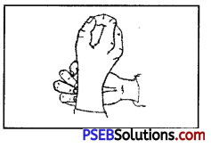
What is Blood Pressure ?
Answer:
PSEB 10th Class Physical Education Solutions Chapter 1 Effects of Exercise on Respiratory System, Blood Circulation, Muscles and Excretion 2
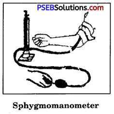
Blood exerts pressure on the walls of those vessels through which it passes. It is called blood pressure. During the period of the contraction of heart, the blood pressure is found to be the lowest in ventricle. During the period of the expansion of heart, Sphygmomanometer the blood pressure is found to be thehighest in big veins. Blood pressure can be measured by shyphogono manameter.

Question 5.
Describe the function of Muscles.
Answer:
Functions of Muscular System:

  • Muscles are joined to the bones in the body.
  • Muscles act as lever in our body.
  • Our body is in movement because of muscles. The various organs of our body function because of muscles.
  • Muscles help in the activities of our body such as eating, breathing, talking, etc. No part of our body can function without them.
  • Muscles maintain balance among various organs of our body.
  • Muscles make use of substances brought by blood in the form of food.
  • Like other cells of the body, muscles too, help in excretory process.

Question 6.
Describe the various types of muscles.
Answer:
Types of Muscles
Muscles are of the following three types :

  1. Voluntary or Striped Muscles.
  2. Involuntary or Unstriped Muscles.
  3. Cardiac Muscles.

1. Voluntary or Striped Muscles:
The muscles which work according to one’s will are known as voluntary or striped muscles. These muscles are related to our brain: Among these types of muscles are those of hands, legs, neck, the upper part of the abdomen, etc. With continuous work these muscles are prone to fatigue. These muscles continue to work on the received message, and provide movement to the body, keep the body safe and produce heat in the body.

2. Involuntary or Unstriped Muscles:
Involuntary muscles are those which are not controlled by one’s will or desire. They continue to work unintendedly. Such muscles are found in heart, liver, intestines, etc. They continue to function even when one is asleep. They help in the functioning of blood circulation and digestion. Their chief characteristics are contraction, expansion and flexibility.

3. Cardiac Muscles.
Muscles of heart are a mixture of the first two types of muscles. But they are not under one’s control.

PSEB 10th Class Physical Education Solutions Chapter 1 Effects of Exercise on Respiratory System, Blood Circulation, Muscles and Excretion

Question 7.
Write down briefly the structure of skin.
Answer:
Skin has two layers :
(i) The outer layer called Epidermis and (ii) The inner layer called Dermis.
Thousand of cells are formed from the inner layer of epidermis. These cells come to the outer surface and die. Everyday we wipe off lakhs of these cells with clothes or towel. Dermis is made of connective tissues. It has many small and big vessels.

Question 8.
What are the main causes of Mental Fatigue?
Answer:

  • Deficiency of nutritional elements in food.
  • Soundless sleep.,
  • More work load than the capacity of an individual.
  • Disease.
  • Lack in concentration.

Question 9.
Describe the functions of kidneys.
Answer:
Kidneys. Kidneys are two in number. These are located towards the back side of stomach. They are in shape like that of bean.
Functions of Kidneys

  1. Urea mixes with blood and enters the kidneys.
  2. These tubes put out toxic substances like uric acid circulatingin arteries and veins around the nerves.
  3. Kidneys filter toxic substances like uric acid.
  4. The waste matter dissolves in water and goes into the big tubes of the tower inside the kidneys.

Tops of the kidney towers have holes. The waste matter and water come in the upper broad portion bymeans of ureter through these holes. From the broad side this urine gets through urethra.

PSEB 10th Class Physical Education Solutions Chapter 1 Effects of Exercise on Respiratory System, Blood Circulation, Muscles and Excretion

Question 10.
What is vital capacity of lungs ? Write in brief.
Answer:
Vital Capacity
PSEB 10th Class Physical Education Solutions Chapter 1 Effects of Exercise on Respiratory System, Blood Circulation, Muscles and Excretion 3
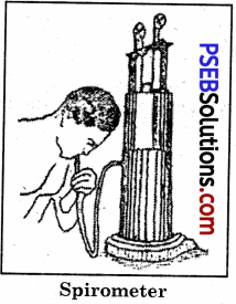
By the vital capacity of lungs we mean that quantity of air which we breathe in of the lungs with the deepest breath. Generally, about 500 cubic cm. air goes into the lungs as we inhale, and about 1800 cubic cm. air comes out of the lungs as we exhale. If we exhale forcefully, another 1500 cubic cm air shall come out but even then about 500 cubic cm. air remains in the lungs. Therefore, we can say that after the deepest inhaling of air, the volumeof air that comes out when air is vigorously exhaled is known as vital capacity of lungs. It is about 4000 cubic cms. The vital capacity of lungs is measured with spirometer.

Question 11.
What is meant by the Composition of Blood ? What are the functions of Blood ? Give its composition.
Answer:
Blood and its composition. Blood is the red coloured liquid found in every part of the body. It sends essential elements to the cells, and carries waste products from there. Composition. If we see a layer of the drop of blood on a glass slide under a microscope we see that there are countless small white coloured particles floating in it. Their colour is slightly yellowish. The collective colour of these countless particles is red. That is why, blood seems to be of red colour.

We can divide blood into the following parts :
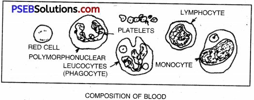
PSEB 10th Class Physical Education Solutions Chapter 1 Effects of Exercise on Respiratory System, Blood Circulation, Muscles and Excretion 4
1. Plasma:
It is a yellow transparent liquid in it the Cells of blood continue to float. It contains 90% water and 10% chemical antitoxic substances. This part of blood contains proteins and their amount comes to about 8%. The protein part is called fibrinogen. It also contains salts. It has sodium chloride, magnesium bicarbonate, phosphorus and iron, etc.The remaining part of blood is made of 0.1% fat amino-acid, glucose, uric acid, cretinin, cholesterol, etc.

It provides strength to the tissues. It prepares anti-toxins to kill disease germs. It also performs the function of excreting waste products of the body through excretory system. It has in it nitrogen and urea mixed and it carries it to the kidneys. Kidneys expel it out of the body through urethra.

2. White Corpuscles:
These cells are colourless and change their shape. They are bigger and smaller in number as compared to red corpuscles. For every 500 red corpuscles there is only one white corpuscle. There are 8000 white corpuscles in a cubic millilitre. They are formed in red marrow of the bones.

PSEB 10th Class Physical Education Solutions Chapter 1 Effects of Exercise on Respiratory System, Blood Circulation, Muscles and Excretion

Their chief function is to protect the body against the invading external germs. Whenever the disease germs attack our body from the outside, white corpuscles fight and kill them. If the white corpuscles are weak, fhey will themselves be killed, and the body will catch the disease. They repair the torn out tissues of our body. If any part of our body receives an injury, they reach the injured place at once and destroy the germs. They also produce anti-toxins in the body.

3. Red Corpuscles:
If we-examine a drop of blood through the microscope, we find that its colour is white or light yellow. If a group of such cells (one drop of blood) they will look red. It has many small corpuscles which cannot be seen with naked eye. They can be seen only with the help of a microscope. They are disc-like in shape, and are made of small flexible cells.

A cubic millilitre has about 5000,000 red blood corpuscles. They have a compound which is known as Haemoglobin. This compound is made of protein and iron. Ordinarily, 100 gm of blood has 15 gm of haemo¬globin. It has the capacity of absorbing oxygen in it, and forms oxyhaemoglobin. Tissues get oxygen from it.The span of life of a red blood corpuscle is about 4 months. It is produced in bone marrow and ends in spleen. The colour of bile is green because of the dead red blood corpuscles.The main function of these types of corpuscles is to carry oxygen to cells. They also do the work of carrying waste products to vessels by means of blood.

4. Platelets/Thrombocytes:
Blood has some other types of cells which are called platelets or thrombocytes. They are born in sunlight and vitaminised food. They also perform the function of protecting the body against germs of diseases. The body swells up when their number decreases. On being hurt, the whole blood- of the body, because of the presence of these cells, stops flowing and the person is saved.

Functions of Blood. Blood is a vital part of our body. It is impossible for us to live without it. It carries oxygen to various parts of our body, and helps expel waste products produced in the body by excretion.There is a very complex network of blood vessels in our body. After the digestion of food, the digested food mixes from the walls of the intestines with blood of the fine blood vessels.

PSEB 10th Class Physical Education Solutions Chapter 1 Effects of Exercise on Respiratory System, Blood Circulation, Muscles and Excretion

The various functions qf blood in our life are as follows:

  • It carries oxygen to the various organs of our body. In the presence of haemoglobin, it carries greater amount of oxygen with it.
  • It performs the function of expelling carbon dioxide produced in our body because of the process of cellular oxidation
  • in the body. It reacts with carbon dioxide and forms sodium bicarbonate. Sodium bicarbonate again undergoes a change
  • in the lungs and gets converted to sodium carbonate and carbon dioxide gets expelled. „
  • It carries digested food in our body to various parts of our body.
  • White corpuscles in the blood protect the body against the invading disease germs.
  • Platelets in the blood perform the function of checking the flowof blood in case of injury.
  • It keeps our body temperature normal.
  • It does the work of carrying such substances as hormones or Anti-toxins to various parts of our body.
  • The nitrogenous substances harmful to the body reach the kidney and get converted into urine and expelled out of the body.
  • Being liquid, blood produces blood pressure in various parts of the body.
  • The Rh factor of blood helps in the sexual selection.
  • Blood does the work of carrying injected medicine to the various parts of our body.

Importance of Blood Circulation:

  • Blood circulation is vital to our life. Human body dies when the blood stops to circulate.
  • It is blood that carries oxygen, digested food and carbon dioxide to various parts of our body.
  • It proves to be helpful in excreting the waste products produced in our body.

Long Answer Type Questions

Question 1.
Describe the various organs of Respiratory System. Discuss the effects of exercise on Respiratory System.
Answer:
By respiration, we mean taking in of air (inhalation) and expelling it out (exhalation). The taking in of air is known as Inspiration, and expelling it out is called Expiration.
(a) Inspiration: Diaphragm is like a round dome. When it contracts, it flattens itself in shape, as a result of which the volume of thoracic cavity increases. The air enters from outside rushes in the lungs through respiratory passage.

(b) Expiration: Expiration takes place because of the coming back to the normal position of the chest wall, being flexible and because of the raising up of diaphragm. The pressure on lungs increases, as a result of which air in lungs get expelled.

Importance of Respiratory System

Respiration is an essential activity not only for human being but also for every living creature. A creature can live for some time without water and food but it cannot live ever for a few moments without respiration.

Important Organs taking part in Respiration
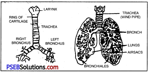
The following seven parts are involved in respiratory system:

  1. Nose
  2. Pharynx
  3. Larynx
  4. Trachea
  5. Bronchial Tubes
  6. Lungs
  7. Diaphragm.

1. Nose.
Nose is the most prominent of all respiratory organs It is a sort of tunnel in the skull. Respiration is possible because of it. The membrane of the nose divides it into two parts. It has three plates of bones in it. .
Functions of Nose.
The functions of nose are as follows :
(i) It warms up the air we inhale. The temperature of the air which we inhale is more than the temperature of the air outside. When air enters the body, it joins the blood vessels and its temperature becomes equal to the internal temperature of the body.

(ii) It purifies the air we inhale. When we inhale, the air from
outside enters our body. This air has numerous dust particles and many other types of bacteria. When this air passes through the nose, the fine hair in the tunnel of the nose separates these unnecessary substances and send pure air into our body. These hair ward off the dust particles and bacteria present in the air at the very outset. These dust particles and diseased germs stick to the soft wall of the nose. This part of the nose has phagocytes which kill the deseased germs and purify the air.

2. Pharynx.
Pharynx is in the shape of a tube made of muscles. It is located in the hinder part of the nose. It is placed below the skull. It has two openings in its hinder part. One of them is called gullet and the other is called glottis for respiration.

3. Larynx.
Larynx is like a box, made of cartilage. This cartilage is made of ligaments joining the muscles. There are membranes on both sides of the larynx, which are called vocal cords. The spacebetween these two membranes is called glottis.

PSEB 10th Class Physical Education Solutions Chapter 1 Effects of Exercise on Respiratory System, Blood Circulation, Muscles and Excretion

4. Trachea.
Trachea, a sort of tube, starts from the larynx and in diameter. It is composed of incomplete rings of cartilage. These rings are not joined to the hinder part because the hinder part of the trachea is flat. The rings are 16-20 in number. The inside surface is like the throat. It has small hair to filter the air. This tube at its lower end divides into two parts. One part goes to the right lung and the other part to the left lung. Every part of it is called bronchus.

5. Bronchial Tubes.
The trachea is divided into two parts. These parts are called bronchial tubes. They have cells like those of trachea. These tubes reach the roots of the lungs.

6. Lungs.
Lungs are the most prominent part of the respiratory system. They are situated on both sides of the heart in
the chest. Each lung is covered by a membrane called Pleura. A sticky substance comes out of its middle wall. It saves small bags of lungs (alveoli) from friction of the walls during the expansion of lungs.Small cells assume the forms of expanded air bags which look like the bunches of grapes. The lungs are spongy because of these air bags. Many blood vessels and nerves pass through lungs and supply them nourishment.
PSEB 10th Class Physical Education Solutions Chapter 1 Effects of Exercise on Respiratory System, Blood Circulation, Muscles and Excretion 5

7. Diaphragm.
The main partition which helps in inhaling is called diaphragm. Ib is like a dome, and its central position is projected towards the abdomen. When we breathe, the diaphragm contracts, becomes straight and pushes the liver downwards. When we exhale, these muscles relax and the diaphragm comes back to its original position.

Functions of Respiratory System
The respiratory system has following main functions
1. Every cell of our body gets oxygen with the functioning of the respiratory system.

2. Oxygen causes oxidation. As a result of this phenomenoh, the body gets rid of the waste products produced in it. During metabolism, oxygen combines with hydrogen to form water and with carbon to form cabon dioxide. Water and cabon dioxide are exhaled during exhalation (breathing out.)

Effects of Exercise on Respiratory System
1. Effect on the Factors of Respiration.
The functioning of the respiratory system depends upon factors like the structure of
blood, blood circulation, alkaline reserve, the size of curved chest, the muscles of chest, stomach membrane and acidic nature of blood. Exercise exerts positive effect on all these factors.

2. Increase in the Blood Circulation of Lungs.
More air passes through our lungs by exercise, as a result of which the exchange of gases becomes complete and rapid. Not only does blood get oxygen in proper quantity but there is also an increase in the blood circulation of lungs.

3.Increase in the Lung Capacity.
The lung capacity increases as a result of doing exercise. The high lung capacity is very helpful in doing hard jobs.

4. Expansion of Chest.
The respiration becomes rapid by exercise. It happens because tissues need more amount of oxygen. As a result, heart and lungs have to exert more vigorously. The muscles of chest have also to exert due to exercise, the result of which is that chest expands.

5. Increase in Vital Capacity.
By doing exercise there is an increase in one’s vital capacity. The chest develops as a result thereof. This development is different in different persons. With long time exercises such as marathon, cycling for a long time, one can increase
if one’s vital capacity.

6. Exit of Greater Amount of Carbon Dioxide and Entrance of Greater Quantity of Oxygen in the Body.
The respiratory system and the blood circulatory system are inter-related. Both the activities increase by doing exercise. Thus the greater amount of carbon dioxide exits our body, and greater amount of oxygen enters our body.

7. Increase in the Resistance Powers of the Body.
Lungs develop uniformly as a result of exercises. The respiratory system improves with exercise and with the improved respiratory system, the resistance power of the body also improves.

PSEB 10th Class Physical Education Solutions Chapter 1 Effects of Exercise on Respiratory System, Blood Circulation, Muscles and Excretion

Question 2.
What are the effects of Exercise on the Circulatory System ?
Answer:
Blood Circulatory System:
Blood reaches various organs of our body. This is known as blood circulation. The group of parts which participate in this process are known as Blood Circulatory System. This system is a blessing to the human beings. It is through blood that various organs of our body get food and oxygen and carbon dioxide and other waste products excrete through the system.

The following organs of our body take part in blood circulatory system :

  1. Heart
  2. Arteries
  3. Veins
  4. Capillaries

Blood plays an important role at the time of exercise. At the time of exercise more oxygen is needed for energy in the muscles. By doing exercise the rate of heart beat increases and more blood flows in arteries. The result is that our blood pressure increases. It increases the blood circulation in the body. With the increase in the blood circulation, there is a corresponding increase in activities of the lungs. As a result of some chemical changes in the lungs, the temperature of the body increases. The blood circulation helps in maintaining the balance in this increased temperature. It also sends the waste product produced as a result of chemical action for exeretion to its right place.

Effects of Exercise on the Blood Circulatory System:
The blood circulation is extremely essential for human body. The proper blood circulation makes our body physically fit and healthy. In order to make the right diagnosis, the blood tests of a patient are done at first. These tests reveal any infection in the blood-circulation. Then, the source of infection is removed and the balanced blood is sent to various organs of body. For balanced blood circulation exercise is of great importance.

Exercise has some special effects on our blood circulation, which are as follows :
1. Exhaling of Proper Amount of Carbon Dioxide.
While doing a strenuous exercise the condition of heart is that there is an increase in blood pressure and frequency of palpitation and there is quick movement in blood circulation. The quantity of oxygen is 0.5% in the position of rest, and it increases by 10% at the time of exercise, 15% of increase is needed at the time of doing a heavy exercise. There is also an exhaling of carbon dioxide.

2. Quick Movement of Blood Circulation.
When a person does exercise there is a quick movement of circulation of blood in his body. Blood takes 21 seconds to complete one circle in a position of rest, while it takes 15,10 or even 8 seconds to do so at the time of doing an exercise.

3. Uniform Temperature of Human Body.
Exercise keeps the temperature of human body uniform. With exercise blood circulates quickly in the human body and keeps the temperature of all body organs, even though these organs are covered with clothes or naked such as human face, hands, feet, etc.

4. Increase in the Working of Productive Capacity of Heart.
The muscles of heart function as a central controller. With every contraction of the heart 5 gm. of blood is sent into aorta. It becomes 4 litres in one minute. When a trained player does heavy work, both the sides of his heart send 30 litres of blood per minute. Thus, the working or productive capacity of heart gets increased in this manner. The ratio between simple non-exercising and exercising condition is 1:7.

5. Change in the Composition of Blood.
Exercise brings about a change in the composition of blood. There is an increase of 10% of haemoglobin and red corpuscles in the blood as a result of exercise. There is also an increase in white corpuscles in the blood. We get more oxygen with the increase in red corpuscles. Our body becomes sufficiently strong to combat diseases with the increase in white corpuscles and these corpuscles work as watchmen of our body.

6. Pure Blood. Pure blood is the base of our body.
It is exercise that helps in forming pure blood in adequate quantity in our body. Alcohol, tobacco and other intoxicants badly affect white corpuscles in the blood. It is only by doing exercise that we can keep whitecorpuscles in good condition.

7. Increase in the Supply of Blood.
Exercise increases the supply of blood in our body. Capillaries expand, and even those capillaries which usually remain closed open as we exercise. There is so much increase in the quantity of blood in the outer capillaries of our body that even the colour of our skin appears to be, red.

8. Supplying Greater Quantity of Blood to a Particular Organ.
Sometimes a particular organ of our body requires greater quantity of blood. For example, our stomach needs more blood after taking food. In this condition the arteries of the stomach expand and blood flows greatly in them. Digestive system, therefore, gets improved with exercise. It is through exercise that blood, the base of our life, circulates properly in our body.
For example, the doctor advises theexercise of the paralysed part of a person suffering from paralysis. According to the doctor, that part may start functioning again with the increased flow of blood in it as a result of exercise. That is why, a player is asked to do exercise.

9. Decreasing the Rate of Heartbeat.
The rate of heartbeat of a common man is 72-80 per minute. But if he begins to do vigorous exercise, the capacity of the blood flow in the arteries of his heart increases, and the rate of his heart beat comes down to 60-65 per minute. Thus, the speed of our heart beat decreases with exercise, and there is an increase in the blood supply in the big artery of the heart.

10. Prevention of Diseases.
As a result of exercise, the blood flows through the veins of our body at a rapid speed. The result is that fat does not deposit on the walls of blood veins and arteries, and there is no blockage in the flow of blood. Consequently, a person who does vigorous regular exercise does not fall a prey to diseases like high blood pressure. Blood circulates slowly in the veins in the bodies of non-exercising persons.

Fat gets deposited on the walls of their veins, as a result of which such persons fall a prey to high blood pressure. For example, if the water in the sewerage pipe that takes the dirty waste matter out of the house flows slowly, Some water with waste matter will remain in the pipe and germs will grow and breed on the dirty waste matter. But if the flow of water in the pipe is fast, all the waste matter will flow out with the rapid flow of water , and no waste matter shall remain in the pipe. Similarly, if the blood flow in our body is fast, there will be no blockage and no disease.

PSEB 10th Class Physical Education Solutions Chapter 1 Effects of Exercise on Respiratory System, Blood Circulation, Muscles and Excretion

Question 3.
What are muscles ? Describe the effect of exercises on Muscular System.
Answer:
Muscular System. Different organs of our body are covered with flesh which is formed of many muscles together. In our body there are over 500 muscles. 45% of the weight of our body is composed of muscles. Muscles are red coloured chunks of flesh which we can see by removing the upper skin of our body.
Parts of Muscles. There are three following parts of muscles.

1. Belly
2. Insertion
3. Origin.

1. Belly.
The innermost and the thickest part of the muscle is called belly.

2. Insertion.
The part of the muscle connected with movable bone is called insertion.
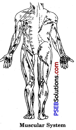
PSEB 10th Class Physical Education Solutions Chapter 1 Effects of Exercise on Respiratory System, Blood Circulation, Muscles and Excretion 6

Muscular System

3. Origin.
The part of the muscle connected with immovable bone is known as origin.

Types of Muscles :
Muscles are mainly of two types.
1. Voluntary Muscles:
Voluntary muscles are those muscles which function according to one’s will, such as the muscles of legs and arms.

2. Involuntary Muscles:
These types of muscles do not function according to one’s will. One’s will or desire has no effect upon them. Such muscles are those of heart, liver and intestines.

Every function of our body depends upon the contraction of muscles. Muscles receive messages from the Central Nervous System. On receiving the messages muscles obtain energy from some chemical changes for contraction, and the fibres of muscles assume a new form. The skeleton of our body is composed of thousands of fibres. Fibres are attached to one another because of connective tissues. These fibres are as thick as our hair, and each of these fibres is 1 to 1.5 inches in length
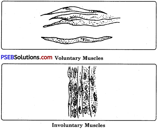
PSEB 10th Class Physical Education Solutions Chapter 1 Effects of Exercise on Respiratory System, Blood Circulation, Muscles and Excretion 7

Involuntary Muscles
Each of these fibres is a cell, and it differs in length- and width. This cell has in it a liquid called sarcoplasm which, in turn has myofibrils which are capable of contraction and expansion. It i$ due to these myofibrils that muscles contract and expand. Each fibre is covered with membrane called sarcolemma.

About a hundred of such fibres form a bundle called Fasciculus. Such small bundles form a bigger bundle, and some bundles give rise to a muscle. There are several blood capillaries in a muscle which distribute blood. These blood capillaries form a sort of network. In the state of rest most of these blood capillaries close, but in the state of action or movement, they open up, thereby fulfilling the need of blood.

Effects of Exercise on Muscular System.
The following changes take place in our muscular system as a result of regular exercise :
1. Moving the Muscles and Total Development of the Body:
The chief objective of exercise is to bring the muscles of body into motion. The development of whole body gets stimulated as a result of regular exercise.

2. Respiration Easy and Effective:
Exercise helps in the expansion of chest muscles. As a result of exercise, respiration becomes easy and effective.

3. Quick Response to Minor Excitement:
As a result of regular exercise, muscles become beautiful and flexible. Their tone also improves, resulting in their quick response even when there is minor stimulation or excitement.

4. Co-ordination between Groups of Muscles:
Co-ordination is developed among different groups of muscles by doing regular exercise, and the habit is developed to work together. If there is no or any lack of this co-ordination, it becomes difficult to do certain tasks.

5. Proper Blood Circulation:
The palpitation of heart increases with exercise. As a result of exercise, blood reaches every part of the body properly and adequately, and the muscles of the heart begin to function properly.

6. Increase in the Power of Muscles:
Exercise brings an increase in the power of muscles. This increase in muscle power depends upon the vigour, tempo and frequency of exercise. The hill labourer and carpenter have long and strong arms because they make maximum use of these parts of body while doing their jobs. Swimming, wrestling, gymnastics, weight-lifting, basketball, football and many other games help in development in the muscle power.

7. Effects on Bones and Joints:
Regular exercise affects bones and joints immensely. By doing exercise the bone muscles become strong and developed. Bones also increase. The bones ofchildren are thin, soft and amorphous. The activity of their muscles have much good effect. Owing to lack of activity their bones remain soft and begin to assume ugly look.

8. Maintaining Muscles in Working Order:
As a result of regular exercise muscles remain in good working order. They are capable of fulfilling various needs of body. They have the power to expand in proportion and in size. It is possible only if we get adequate food. But if muscles are not put to proper use, even the good food will fail to bring about any increase in their size and power.

9. Increase in the Size of Muscles in Length and Breadth:
By doing exercise one can increase muscles in size, in length as well as breadth. For example, if one exercises arms with weight or perform ‘dandas’, there will be an increase in the size of arm muscles. The biceps and triceps of arms will begin to looks strong and thick.

10. Assistance to Maintain Correct Body Posture in Old Age:
As a result of regular exercise muscles in the body become strong and increase in size. It helps one in old age in keeping correct body posture. But if one has not done exercise and the muscles have remained weak, one may suffer from hunchback and other bad states of health in old age.

11. Increase in the Neuro-Muscular Co-ordination:
Regular exercise increases the neuro-muscular co-ordination. For example, a player hits the ball, the rival player is able to block the hit by immediately turning his body the moment the hit is taken. The kick is made in the twinkling of an eye but the rival player is able to stop the ball because of his excellent neuro-muscular co-ordination.

12. Increase in the Speed of Deoxygenated Blood towards the Heart:
When we do exercise oxygenated blood reaches the minutest cells of the muscles in our body, and deoxygenated blood therefrom quickly travels to the heart for purification. By doing exercise one increases the speed of deoxygenated blood towards the heart, because with exercise the cells need more oxygenated blood.

PSEB 10th Class Physical Education Solutions Chapter 1 Effects of Exercise on Respiratory System, Blood Circulation, Muscles and Excretion

Question 4.
What are the effects of exercises on the Excretory System?
Answer:
Excretory System:
Excretory system is the one by which harmful and wasteful products are excrete from our body. If these useless and harmful products remain inside the body, the body becomes a victim of many diseases. Among these wasteful products are urea, carbon dioxide, perspiration and water. These products excrete through different organs like lungs, kidneys, skin and intestines.

Effects of Exercise on Excretory System:
Exercise has good effect on excretory system. Some of these.good effects are as follows

  1. Body gets activated as a result of exercise. The blood circulation increases thereby. Due to exchange of gases in the body, food elements get digested and waste products get excreted. It helps in keeping the temperature of the body uniform.
  2. Muscles have to get into motion as a result of exercise. It results into some body change. The dirty elements come out of the skin, and the body remains free from skin diseases.
  3. With exercise poisonous and waste products continue to be excreted from body. Diseased germs do not get accumulated in the body. The body becomes able to fight out these diseased germs.
  4. Kidneys expel out waste products in the form of urine. They act as sieve. With exercise they become activated and efficient.

Question 5.
Write a short note on the followings :

  1. Functions of Skin
  2. Kidneys
  3. Heart
  4. Arteries and Veins

Answer:
1. Skin and their Functions

Skin-Structure and Functions:
Skin is the outermost covering of the body. It keeps the whole body covered, and protects all the muscles and other organs of the body. It maintains the body temperature.

Structure

Skin has two layers:
(i) the outer layer called Epidermis and
(ii) the inner layer called Dermis.

Epidermis: The outer skin, that is, epidermis, is made by mixing of several layers of cells. The first layer is made of lifeless, hard transparent and colourless, countless cells. Its thickness is different in different parts of the body. It is 1/200 cms., on the face and 1/20 cm. on the heels. It has no blood vessels.

So when this part of the skin in cut, neither does the blood flow nor is pain felt. Just as a snake casts away its outer skin, so does our outer skin get worn out and old skin is replaced with the new. There are pigment grains in the lower surface of the epidermis. They are greater in number in dark coloured people as compared to the fair-complexioned. The main function of epidermis is to protect dermis.
PSEB 10th Class Physical Education Solutions Chapter 1 Effects of Exercise on Respiratory System, Blood Circulation, Muscles and Excretion 8

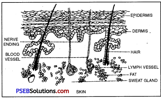
If we examine the skin under a microscope, we see very small holes. These are the mouths of sweat glands by means of which the waste products of the body come out in the form of sweat.

Dermis:
It is also known as inner-skin. It is below the outer skin, that is, epidermis. It is made of connective tissues. It has many small and big blood vessels. Moreover, there are nerve fibres which function like small machines.It continues to collect feelings, experiences, excitements and sensations.. The collection of these sensations reaches the brain.

Skin Glands:
There are two types of glands in the inner skin.
1. Sweat Glands.
The sweat glands are 20-50 lakhs in number. These are present in all organs of the body except lips, sex organs, etc. They are present in greater number on the palms of the hands and soles of feet. Sweating results in lowering of body temperature. When sweat dries up, it takes up heat from the body, as a result of which the body temperature is lowered.
2. Sebaceous Glands. These glands are related only to the roots of the hair.
When sweat is formed, it does not have foul sihell, but when the bacteria of the skin act upon it, it starts emitting foul smell.

Functions of the Skin:

  • It covers and protects the body.
  • It protects our body from heat and cold.
  • It is an organ of excretory system. It purifies blood by excretingwaste products such as urea and non-living mineral substances through sweat.
  • It keeps the body beautiful. Had there been no skin, our bodyWould have looked like a dreadful skeleton.
  • It maintains the temperature of the body.
  • It produces in us the sensations of warmth and coldness.
  • It acts as a sensory organ.
  • It prevents disease germs from entering our body.

2 Kidneys

Structure and Functions of Kidneys

Kidneys: Kidneys are two in number. These are located towards the back side of stomach. They are in shape like that of bean. They help in excreting urine from the body. They keep the quantities of water and blood equal. Urea, uric acid, minerals etc. continue to be excreted from the body through these orgAnswer:If it is cut and viewed, an empty space will be seen. There are fine tubules around this empty space. They are pretty long and curve together to join other tubules.
PSEB 10th Class Physical Education Solutions Chapter 1 Effects of Exercise on Respiratory System, Blood Circulation, Muscles and Excretion 9
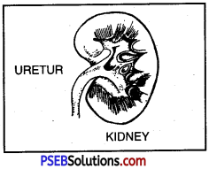
The external part of each kidney is convex while the internal is concave. The open space in the concave part is known as Hilum. It is here that the renal artery enters and the renal vein comes out of the kidney. It collects the blood and takes it to the renal vein. Every ureter is 10″ long and opens into a bag after covering full distance. This bag is known as urinary bladder. Urine collects in this bag.

PSEB 10th Class Physical Education Solutions Chapter 1 Effects of Exercise on Respiratory System, Blood Circulation, Muscles and Excretion

Functions of Kidneys:

  • The waste matter of the body mixes with the blood and forms urea. Urea mixes with blood and enters the kidneys.
  • Urea mixed with blood comes into the cells of the kidneys.
  • These tubules pull out toxic substances like uric acid circulating in arteries and veins around the nerves.
  • Kidneys filter toxic substances like uric acid.
  • The waste matter dissolves in water and goes Into the big tubes of the towers inside the kidneys.
  • The tops of the kidney towers have holes. The waste matter and water come in the upper broad portion by means of ureter through these holes.
  • From the broad side this urine gets excreted through urethra.

3 & 4 Heart, Arteries and Veins:

The major portion of the amount of blood of the human body remains in this part. It is made of flexible tissues of flesh. It is an extremely delicate and the most important organ of the body. It is located to the left of the chest. It resembles a closed fist in size.
PSEB 10th Class Physical Education Solutions Chapter 1 Effects of Exercise on Respiratory System, Blood Circulation, Muscles and Excretion 10

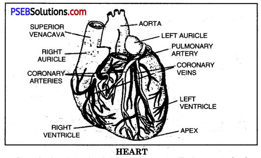
Lengthwise, it is divided into two parts. Each part is further divided into two parts upper and lower parts. The upper parts are called auricles, and the lower parts are called ventricles. The pure blood from different parts of the body reach the right auricle by veins and then reach the right ventricle by tricuspid valve. From right ventricle blood reach lungs for purification through pulmonary artery, and on its way back oxygenated blood reach left auricle of the heart. It reaches the left ventricle by bicuspid valve. From the left ventricle blood reaches different parts of body through Aorta. Thus, the blood continues to circulate in this manner.

Veins and Arteries
The pipes which bring the blood from lungs, and from other parts of the body to the heart are known as veins. The structure of the walls of veins resembles that of arteries, but the layer of their flexible tissues and muscles is very thin. Except pulmonary vein, all other veins carry the deoxygenated blood to the heart.

Arteries:
Arteries carry the oxygenated blood from heart to various parts of our body. These are made of flexible, but thick walls. Oxygenated blood flows through them. But the artery which carries blood to lungs has in it deoxygenated blood.This artery carrying deoxygenated blood is known as Pulmonary Artery. The prominent of all arteries is called Aorta.
PSEB 10th Class Physical Education Solutions Chapter 1 Effects of Exercise on Respiratory System, Blood Circulation, Muscles and Excretion 11

Kabaddi Game Rules – PSEB 10th Class Physical Education

Punjab State Board PSEB 10th Class Physical Education Book Solutions Kabaddi Game Rules.

Kabaddi Game Rules – PSEB 10th Class Physical Education

Question 1.
Mention the length and breadth of the Kabaddi ground. Describe the main rules of the game?
Answer:
Playground:
The playground shall be rectangular, level and soft. It should be made of earth, manure or saw dust. For men, it is 12.50 metre long and 10 metre wide. For women and juniors, it is 11 metre long and 8 metre wide. It is divided by a centre line into two equal parts. There shall be a strip of one metre on each side of the playfield. It is called Lobby. In each half at a distance of 3 metres on the centre line and parallel to it, lines of the full width of ground shall be drawn.

These lines are called Baulk lines. The mid-line should be distinctly marked. The width of the mid-line and other lines should not exceed 5 cms, or 2 inches. Outside the side line and towards the end line a space of 4 metres should be left empty. The sitting block shall be 2 metres away from the end line. The sitting block for men shall be 2 m × 8 m., and for women and juniors it shall be 2 m × 6 m.

Bonus Line:

  1. This line is at a distance of 10 cms. from the baulk line, and for seniors, it is at a distance of 1 metre from the baulk line.
  2. When a raider comes after having crossed it fully, he does not get any point for it.
  3. If a raider after having crossed the bonus line is caught, the opposing team is awarded a point.
  4. If a raider succeeds in crossing the bonus line and also touching an opponent, he is given one point.

kabbadi court image 1

Officials:

  1. One referee
  2. Two umpires
  3. Two linesmen
  4. One scorer

The decisions of the umpire are final, but they can be changed under special circumstances. When the referee considers the decision wrong, he announces his own decision.

Players Dress:
The player’s dress includes a banyan and nicker (half pant). Then there is ‘jangian’ or join-cloth below. The use of safety pin and ring is prohibited. Nails should be pared.

Kabaddi Game Rules - PSEB 10th Class Physical Education

Rules of The Game

1. The toss winning team shall have the right to choose the end of raid.

2. A player who goes out of the boundary during the play shall be considered ‘out’.

3. If anjapponent goes out of the boundary and catches the raider, the raider shall not be considered ‘out’ but all the players catching him shall be ‘out’. The raider shall come back to his side and take part in their game.

4. Lobby is also considered to be the limit of the game when the struggle starts. When the struggle is over, players in the struggle can enter the respective lobby.

5. A raider should go on sounding the words ‘Kabaddi-Kabaddi’ while entering the court of the opponents. If he starts the cant of Kabaddi only after he has entered the opponent’s court, he is ordered back by the umpire and the opponent shall be given the chance of raiding.

6. If even after the warning the raider deliberately violates the rule, the umpire shall declare his turn over, and his opponent shall be awarded one point, but he shall not be declared out.

7. After a raider has returned to his court, the opposing team shall immediately send its raider. So each side shall send its raiders alternately until the end of the play.

8. If a raider caught by opponents escapes and reaches his side safely, he shall not be pursued thereafter.

9. Only one raider shall go to the anti-court at a time. If more than one raiders reach the anti-court, the umpire shall order them to return to their court, and their turn of raiding shalLbe over. The opponents who touch them shall not be declared out. They shall not pursue the raiders to send them out.

10. If after the warning a player violates the rule, the umpire shall end his turn, and award one point to the opponents, but he shall not be declared ‘out’.

11. If a raider loses his cant in the anti-court, he shall be reckoned to be ‘out’. But if it happens as a result of the use of unfair means by the opponents, then he shall be deemed to have returned safely to his court.

12. No player shall push his opponent violently out of his boundary. The one who does so shall be considered ‘out’, and the raider shall return safely to his court.

13. Until the raider is in the anti-court, no opposing player shall touch with any part of his body the ground of the raider’s court beyond the mid-line.

14. If a player who violates the Rule no. 12 catches the raider or helps others in catching him, the raider shall safely return to his court, and all the opponents involved in the struggle shall be ‘out’.

15. If a player enters the anti-court out of turn, the umpire shall order him to come back. If after the warning by the umpire he does so again, the opponents shall be given one point.

16. According to new rules, it is not a foul to get water from outside and drink it.

17. When a team makes the entire opposing team out, it is successful. Two points are added to the points it has scored in making the opponents out. The players of both the sides shall enter their respective courts, and the game shall continue upto the end of time.

18. If a player warns a raider against any danger by the opponents, the umpire shall award one point against him.

19. No raider or opponent can be held by any part of his body other than his waist, hand or foot. He who violates this rule shall be declared ‘out’.

20. During any play if only one or two players of a team are left and the captain of the opposing team declares them out in order to bring in the play the whole of his team, the opponents shall score as many points as there are players and additional two scores of Lona.

21. With the opponents being out, the out-players of the team shall be put in the game in the same order in which they were out.

22. New Rules – If the match remains suspended for 20 minutes because of injury to some players, the match can be replayed.

23. The match can be started with five players. But when the five players are out, we shall consider full Lona, that is, 5 + 2 score, of players and 2 scores of Lona.

24. Lona has two scores.

Kabaddi Game Rules - PSEB 10th Class Physical Education

Question 2.
Write five main rules of the Kabaddi match and its violations?
Answer:
Rules Of The Match
1. Each team has twelve members in all, out of which only 7 shall enter the ground together. The remaining shall remain in reserve.

2. For men the game shall have two durations of 20 minutes, and for women, two durations of 15 minutes. There shall be an interval of 5 minutes between these durations of play. The ends shall be changed after the interval.

3. For each player going ‘out’, the opposing team shall be given one score. The team getting Lona shall be given two scores.

4. At the end of the game the team having more scores shall be declared the winner.

5. If the match ends in a draw, two extra durations of 5-5 minutes for play shall be granted. During the extra time the game shall be continued by the end players of the other team. If the tie occurs at the end of 50 minute game for men or 40 minute game for women, the team that scores the first point shall be the winning one.

6. If no score is made during the whole 50 minute game for men or 40 minute game for women, the toss winning team shall be declared the winner.

7. If a match cannot be completed due to some reason, it shall be re-played.

8. In case of an injury to a player, the captain shall ask for a time out. But the duration of the time-out shall not be more than two minutes. The injured player can be substituted. Before starting the second turn of the game, two players can be substituted.

The game can be started by one or two or minimum number of players. At the start of the game those players who are absent can join the game later at any time, but the referee must be informed. If the injury to a player is serious, the injured player can be substituted. By the end of the first game, only two players can be substituted.

9. A match may be started if there are five players in a team but

(i) when the seven players of the team are out, the absent players shall also be ‘out’ and the opposing team shall be awarded Lona, (ii) the absent players can join the game with the referee’s permission.

(iii) the substitutes can be taken in place of absent players any time, but when they are so taken, no player can be substituted till the end of the match, and (iv) any player can be substituted in case the match is re-played.

10. Playing by using oil on the body is not permissible. The nails of the players should be pared well. The players shall wear banyan, underwear the nicker (half pant). Rubber-soled shoes and socks may be put on, if necessary.

11. During the play except the captain or leader, no player shall instruct. The captain can instruct only in his own half.

12. For junior boys and girls the duration of play is 15-5-15 minutes, out of which the interval is of 5 minutes.

Various Fouls and Violations in Kabaddi Fouls.

  • To try to stifle a raider by shutting his mouth or throttling him.
  • Using violent tackling by one player against the other.
  • Instruction or coaching cannot be done from the outside.
  • To hold the raider with the half of leg-scissors.
  • It is a foul when player on rest takes more than five minutes.
  • To take more than five seconds to send a raider by a team.
  • The referee can remove such players from the game by deducting their scores or marks. The whistle shall not be blown during the time of struggle.
  • To catch by hair or clothes intentionally is foul.

Violations

  • Violating the rules or decisions time and again.
  • Using derogatory remarks against the officials.
  • To show insulting behaviour to the officials or to try to influence their decisions.
  • To make insulting remarks to the opponent.

FOULS PLAY:
Referee or umpire will control the match of tournament by using the cards:

GREEN CARD:
Warning to player or coach.

YELLOW CARD:
Temporary suspension for 2 minutes.

RED CARD:
Suspension for the match or for the tournament

Kabaddi Game Rules - PSEB 10th Class Physical Education

Important Information About the Kabbadi Game

  • The length of the ground for men = 13 Metre
  • The Breadth of the ground for men = 10 Metre
  • The length of‘the ground for women = 12 Metre
  • The breadth of ground for women = 8 Metre
  • The length and breadth for Junior boys & girls = 11 × 8 metre
  • Total number of players in a team = 12
  • Duration of the match for men = 20-5-20 Minutes
  • Duration of play for women = 15-5-15 M.
  • Breadth of the lines = 5 cms.
  • Points of Iona = 2 points
  • Size of sitting block for men = 1 × 8 M.
  • Size of sitting block for women = 1 × 6 M.
  • Officials of the match = One referee, Two umpires, one scorer, one time-keeper, two linemen
  • Each team has 7 players. Seven players shall play in ground at one time. There are 5 substitutes.
  • The team that wins the toss chooses the end and also gets an opportunity of the raid first.
  • The game has two durations of 20 minutes each with an interval of 5 minutes. For women and juniors the duration of the game is 15-5-15 minutes, out of which there is an interval of 5 minutes.
  • If any player leaves the ground, he shall be declared ‘out’.
  • If any part of the body of a player touches the outside of the boundary of the ground, he shall be ‘out’.
  • If the match is not completed for some reason, it shall be replayed.
  • A player cannot use oil or any greasy matter on his body.
  • During the game no player can hold the other player by leg scissors.
  • A substitute may take the place of a player if he is injured.
  • The captain can take a time-out with the permission of the referee, but the duration of the time-out should not be more than 2 minutes.
  • The player can be given water from outside the boundary. If water is given inside the boundary, it is a foul.
  • A team can substitute three players.
  • If a team gets a Lona, it is given additional two points.
  • Substitutes cannot be substituted again.

Handball Game Rules – PSEB 10th Class Physical Education

Punjab State Board PSEB 10th Class Physical Education Book Solutions Handball Game Rules.

Handball Game Rules – PSEB 10th Class Physical Education

Question 1.
Give an introduction to the Handball game?
Answer:
Handball-An Introduction:
Handball is a team sport. Two teams participate in this game. Each team has 12 players, out of which 10 are court players and 2 are goal-keepers. Not more than 7 players enter the court at a tinine. Out of these 7, 6 are court players and 1 is a goal-keeper. The remaining 5 players are substitutes. A player may be included in a game or a substitute may be allowed for him. No one else but a goal keeper is allowed in the goal area.

The game starts in the middle of the court as soon as the referee whistles for a throw-on. The duration of the game for men is 30-10-30 minutes, while for women it is 25-10-25 minutes.

Each team tries to put the handball into the goal of the rival team, and tries to defend its own goal against the rival attacks. The ball is played by hands, but it can be touched by knees or any other part of the body. Only a goal-keeper can touch the ball by all parts of his body. A player can be substituted any time during the play. There is no time out in this game.

The players, running, walking or standing, can toss the ball with single hand. A player with a ball can move forward, but he cannot move more than three steps. A ball can be held for three seconds at the most. If a player gets hint, the game can be stopped on the referee’s orders, and the substitute enters the court in case of need. The weight of the ball for men is 475 gms. and for women, it is 425 gms. The circumference of the handball is from 58 to 60 cms.

After a goal has been scored, the game shall re-start from the middle of the court with a throw-on. The throw-on-shall be done by that player against whom a goal has been scored. If the ball goes out during the play, the rival team gets a throw from that place. After half-time the goal and throw-on shall be changed.

A team that scores more goals is declared the winner. If the number of goals scored by both the teams is equal or if no goal is scored, the match shall end in a draw. Each game shall be conducted by two referees who are assisted by a scorer and a time-keeper. Referees enforce the rules of the game. Referees are the managers of the match from the start to the finish.

Handball Game Rules - PSEB 10th Class Physical Education

Question 2.
Mention the Play ground, Goal, Ball, Players, Duration of the game, Goal area, Score, Throw-in, Comer throw, Goal throw, Free throw and Penalty throw in the game of Handball.
Answer:
Playground:
The playground is divided into two circular areas, The court of the game is rectangular with a length of 40 metres and width of 20 metres. The thickness of each line is 0.5 cm. The height of the poles is 7 feet, while their width is 3 metres. A‘D’ is marked 6 metres in front of the poles. The penalty area is 7 metres away from poles. In special circumstances, the play area may be 38-44 metres in length and 18-22 metres in width.

Handball image 1
Handball image 2
Handball image 3

Goals:
Goals shall be in the centre of goal lines. There shall be two straight poles in each goal parallel to and at an equal distance from the corners of the playfield. The poles shall be 3 metres from each other and 2 metres in height. They shall be firmly planted in the ground, and linked properly with each other with a horizontal cross-bar. The outer end of the goal line and the back end of the goal post shall be in one line.

Poles and cross-bar shall be square and of the size of 8 × 8 cms. They shall be made of wood, light metal and synthetic material. They shall have two colours on all sides and shall be distinctly different from the background.

Each goal shall be marked with a line of 3 metres, 6 metres from goal area and parallel to the goal line. The ends of this line shall be linked by quarter circles to goal line. The circumference of these circles shall be 6 metres from the back of the inner cover of goal poles. This line is called goal-area-line. Penalty line is marked at a distance of 7 metres, from the centre of goal post, and the second free throw line at a distance of 9 m.

The Ball:
The handball should be spherical, with a rubber bladder, and its outer cover should be made of leather of one colour or of synthetic material. The outer cover should neither be bright nor slippery. The ball should not be inflated too much. Its weight for men and seniors shall not be more than 475 gms. or less than 425 gms. Its diameter shall be from 58 cms. to 60 cms. For all women and junior boys, its weight shall not be more than 400 gms..and not less than 325 gms. Its diameter shall be from 54 to 56 cms.

Players:
Each team has 12 players in all, out of which 10 are court players and 2 are goal-keepers. But only 7 players can participate in the game at one time, out of which 1 is goal-keeper and 6 are court players. In case a player is hurt, a substitute player comes in his place to play the game.

Duration of Game:
The duration of the game for men is 30-10-30 minutes, while for women it is 25-10-25 minutes. There is no time out in the game. The referee can take official time-out, if needed.

Note:
In tournaments, the game is played into two durations of 30 minutes each with no interval.

Handball image 4
Handball image 5

For women and juniors, the game is divided into two durations of 25 minutes each with an interval of 10 minutes.

Note:
In tournaments, the game is played in two durations of 10 minutes each state interval. For all other teams, it shall be played in two equal durations of 20 minutes each.

Goal:
A goal cannot be scored against the rivals by a direct throw-on.

Playing the Ball:
The following methods of play are allowed:

Blocking the ball, catching, throwing, tossing or hitting it in any way or direction (with palms or flat hands) by using arms, head, body, knees etc are valid.

When the ball lies on the ground, it can be held for three seconds at the most. To walk with the ball for three steps is valid.

Handball Game Rules - PSEB 10th Class Physical Education

The Goal Area:
The goal-keeper alone is entitled to enter or remain inside the goal-area. The goal-keeper is considered to be entered if a player touches him in any way. The goal area line is included in the goal area. The following penalties are awarded on entering the goal area:

Handball image 6

  • Free-throw, when the ball is in the court player’s possession.
  • Free-throw, when the ball is not in the court player’s possession but he has clearly taken the advantage by entering the goal area.
  • Penalty-throw, when any player of the defending team knowingly and clearly enters the goal area for defence.

Scoring:
A goal is considered to have been scored when the hall passes through the goal line of the rivals through the goal posts under the cross bars, provided the scorer or any player of his team has not violated the rules.

Throw-in:
If the ball crosses the boundary line or goes out of side line in the air, the game shall be re-started by a throw-in. The throw-in is taken by that player who has been last touched by the ball. The throw-in is taken from the point from where the ball has crossed the side-line.

Corner-throw:
When the ball passes the goal line outside the goal by the player of the defending team when touched for the last time, the attacking team is awarded a corner throw. This rule is not applicable on the goal-keeper in his own goal area.

Handball image 7

Within 3 seconds of the court referee’s whistle the corner throw shall be taken from the same point of the goal side where the touch line and goal line meet each other, and from where the ball has gone out. The players of the defending team can take positions along the goal area line.

Goal-throw. Goal-throw is given in the following circumstances:

  • When the ball crosses from above the goal line on the ground, in the air, having touched by the players of the attacking team or when the goal-keeper of the defending team has touched it in the goal-area.
  • When the ball passes straight in the goal of the rival team by throw-in.

Free-throw:
Free-throw is awarded in the following circumstances:

  • On a player’s entering or leaving the playground in a wrong manner.
  • On a player’s making the throw-in wrongly.
  • On a player’s violating the rules.
  • On a player’s knowingly playing the ball outside the side line.

Handball Game Rules - PSEB 10th Class Physical Education

Penalty-throw:
Penalty-throw is awarded ‘when a player:

(i) makes a serious violation of rules in his own half.
(ii) makes a serious violation of rules in the court, area, spoiling the possibility of a clear goal.

Handball image 8

GOAL KEEPER’S POSITION FOR PREVENTING SCORING

(iii) enters his goal area intentionally with the aim to defend.
(iv) pushes the ball intentionally in his goal area and the ball touches the goal-keeper.
(v) or when a goal-keeper carries the ball in his own goal area.
(vi) or when a goal-keeper spoils a clear possibility of scoring a goal in the opponent’s half of court.
(vii) or wdien there is a wrong substitution of a goal-keeper.

Question 3.
Describe the number of officials conducting the Handball game.
Answer:
Officials
The following officials conduct the game of handball:

(i) Referee-1
(ii) Umpire-1
(iii) Time-keeper-1

Decision:
The team that scores more goals is declared the winner.

Handball image 9

Handball Game Rules - PSEB 10th Class Physical Education

Important Information About the Handball Game

  • Number of players in a team = 12
  • Number of players on the court = 7
  • Number of goalkeeper in a team = 2
  • Number of players who actually play = 7 (6 court – player one goal keeper)
  • Circumference of the ball = 58 to 60 cm
  • Duration of play for men = 30-10-30 minutes
  • Duration of rest = 10 minute
  • Weight of the ball for men = 425 to 472 grams
  • Weight of the ball for women = 325 to 375 grams
  • Circumference of the ball for men = 58 to 60 cm
  • Circumference of the ball for women = 54 to 56 cm
  • The game of handball is played between two teams
  • The game starts with the pass from one team to the other from the centre line.
  • The duration of the game for men is 30-10-30 minutes while for women it is 25-10-25 minutes.
  • The total number of players in each team is 12. The number of players to participate in the game is 7; the remaining five players are substitutes.
  • The player can be substituted any time during the play.
  • If a player gets injured, the game can be stopped on the orders of the referee, and the substitute enters the playfield, in case of need.
  • To run with the ball is considered to be a foul.
  • The weight of the handball for men is 475 gms, while for women it is 425 gms.
  • The circumference of handball is from 58 cms. to 60 cms.
  • If the ball goes out of the court, the rival team gets a throw from that place.
  • To push any player deliberately during the game is considered to be a foul.
  • A referee and an umpire conduct the game.
  • The length of the playground is 40 metres, and the width is 20 metres.
  • The goal-keeper cannot leave the outer D.
  • There are two D’s in the game of handball.
  • If a player with the ball is proceeding towards the D, and if a rival catches him by the arm, the referee awardg a penalty.

PSEB 10th Class SST Solutions Geography Chapter 1 India: An Introduction

Punjab State Board PSEB 10th Class Social Science Book Solutions Geography Chapter 1 India: An Introduction Textbook Exercise Questions and Answers.

PSEB Solutions for Class 10 Social Science Geography Chapter 1 India: An Introduction

SST Guide for Class 10 PSEB India: An Introduction Textbook Questions and Answers

I. Answer the following questions objectively :

Question 1.
What is the basis of naming Bharat as ‘India’?
Answer:
India got its modern name from Sindhu river.

Question 2.
What is the situation of India on the globe?
Or
What is geographical position of India on the globe? (Pb. 2019)
Answer:
It is situated in the Northern hemisphere.

Question 3.
What are the geographical divisions of Northern and Southern India?
Answer:
Plain and Plateau Division.

Question 4.
What is the location of India in respect of Indian Ocean?
Answer:
India has central position in Indian Ocean.

Question 5.
Which countries came in direct contact with India because of the nearness of its coastal boundaries with Indian ocean?
Answer:
Maldeep , Sri Lanka.

Question 6.
What are th/e evidences for the powerful naval force of India?
Answer:
India’s naval army tried to curb the terrorism in Sri Lanka in last decade.

PSEB 10th Class SST Solutions Geography Chapter 1 India: An Introduction

Question 7.
What is the extent of India?
Answer:
India extends between 804’ and 3706′ north latitude and 6707′ and 97025′ east longitude.

Question 8.
What is the area of India?
Answer:
The area of India is almost 32,87,263 square kilometres.

Question 9.
Compare the area, currency, population and literacy of India with that of Pakistan?
Answer:
Do it Yourself with the help of your teacher.

Question 10.
What is the North-South and East-West extent of India?
Answer:
The North-South extent of India is 3214 km and East-West extent is 2933 km.

Question 11.
What is the length of land and coastal boundaries of India?
Answer:
The length of land frontiers is 15,200 km. and the length of coastal boundaries is 7,517 km.

Question 12.
What do you mean by sub-continent?
Answer:
A subcontinent is part of a larger continent. It is made up of a number of countries that form a large mass of land. The subcontinent is often used to refer to the area that contains India, Pakistan, and Bangladesh.

Question 13.
What is Cultural fusion?
Answer:
Cultural fusion is a phenomenon which emerges when two or more cultures inter¬mingle and produce a new culture.

Question 14.
What is the rank of India in the world in terms of area?
Answer:
India ranks seventh in the world in terms of area.

Question 15.
Which countries share the land frontiers with India?
Answer:
Pakistan Nepal Bhutan, Myanmar (Burma) and Bangladesh and China.

Question 16.
What were the political division of India before Independence?
Answer:

  • Princely State
  • British Provinces.

Question 17.
What work was done by the State Reorganization Commission?
Answer:
It reorganised boundaries of the states on linguistic basis.

PSEB 10th Class SST Solutions Geography Chapter 1 India: An Introduction

Question 18.
When was the present Punjab state created?
Answer:
Present Punjab came into existence on November 1st, 1966.

Question 19.
What is the present administrative division of geographical set up of India?
Answer:
India has 28 states and 8 union territories.

Question 20.
Name the largest and smallest States of India in terms of area and population.
Answer:
Rajasthan is the largest and Goa is the smallest state of India in terms of area. Uttar Pradesh is the largest and Sikkim is the smallest state of India in terms of population.

Question 21.
What is the number of members in the two houses of Parliament?
Answer:

  • Lok Sabha-545
  • Raya Sabha-250.

Question 22.
Name some of the important religious places of India.
Answer:
Amritsar, Bodh Gaya, Badrinath, Varanasi, Allahabad etc

Question 23.
To which regions of India major groups of people came through migration.
Answer:
From villages to urban areas.

PSEB 10th Class SST Solutions Geography Chapter 1 India: An Introduction

Question 24.
In which areas/fields the country has failed on large scale?
Answer:
To provide Employment to a large population

Question 25.
Write the names of major folk dances of India.
Answer:
Bhangra. Gidha, Bhart Natyam, Kyttchipuddi etc,

II. Answer the following questions in short :

Question 1.
Is India a sub-continent?
Or
What is a sub-continent?
Answer:
India is called a sub-continent on the basis of its size and location :

  1. Physical features separate it from adjoining areas.
  2. In the Northern part, Trans Himalayan ranges Aghil, Muztagh, Kunleun, Karakoram and Hindukush separate it from N.W. of Asia.
  3. Palk Straits and Gulf of Manar separate it from Sri Lanka in the South. Arakans separate it from Burma (Myanmar) in the East.

Question 2.
What type of cultural diversities are found in India?
Answer:
People belonging to different Religions and castes live in different parts of India. Great diversity is found in their languages, food, clothing and mode of living. Their folk songs, festivals, fairs and customs are different. There are 187 spoken languages. 23 languages are spoken in 97% of area. In Constitution of India, 22 languages have been recognised. In fact, diversity is found in every aspect of life.

Question 3.
Write a note on India’s Land Extent.
Answer:
The Indian subcontinent extends from 8°4′ North to 37°6′ North latitudes and 68°7′ East to 97°25′ East longitude.

The Tropic of Cancer passes through the centre of the-country. The area of Northern India is twice than that of Southern India. It has a North-South extent of 3214 km. from Kashmir to Kanyakumari; and an East-West extent of 2933 km. from Arunachal Pradesh to Rann of Kutch. Its effect is that when the sun is rising in Arunachal Pradesh, it is the last quarter of night in Gujarat.

Question 4.
What is the contribution of Indian languages and arts to the unity in diversity of India?
Answer:
The languages and folk arts have an important role in the unity of India. Take up the case of Sanskrit. In India, Vedas and other ancient scriptures are written and learnt in Sanskrit. It goes to the credit of Sanskrit language that Vedas are read from Rajasthan to Manipur. Urdu came into existence as a mixture with Sanskrit. It was recognised by Delhi Rulers in Medieval period. Nowadays English is a link language and Hindi a national language. The folk songs, heroic ballads, film songs have encouraged fine arts in India.

PSEB 10th Class SST Solutions Geography Chapter 1 India: An Introduction

Question 5.
Describe India’s regional diversity through any two facts.
Answer:

  1. Vast Size: A great diversity is found due to a large East-West and North South extent. It is called a sub-continent due to its size. It is natural that diversity is found in Natural and Human elements.
  2. Relief: India has old fold mountains like Aravallis as well as young fold mountains like Himalayas. The Southern Plateau is an ancient block of hard rocks. Great plains exist between the Himalayas and the plateau.

Question 6.
Elaborate India’s unity in diversity any two factors.
Answer:
1. There is a great diversity in relief: In the North Himalayas exist while plateau is found in the South. The Northern plains deepen the.diversity. Still Monsoons provide a climatic unity. Most of rainfall is through Monsoons.

2. 187 languages are spoken in India. 23 languages are spoken in an area of 97%. Still Sanskrit language has united the whole country. English as a link language and Hindi as National language provide a unity in diversity.

Question 7.
What has been the contribution of natural diversity towards cultural variations in the country?
Or
What is contribution of natural diversity towards cultural variation in India?
Answer:
India is a vast country. Many contrasts are found due to vast size. People wear woollen clothes in hilly areas and their life is according to environment. People in peninsular plateau work under harsh conditions. Their methods of cultivation .differ from those in other parts. On the other hand, people in plains have utilised their sources to the maximum extent to raise their standard of living.

Question 8.
When the sun is rising in Arunachal there is still night in Gujarat.’ Explain.
Answer:
India extend between 68°7′ E to 97° 25′ E longitudes. The East-West extent is 2933 km. which is roughly l/12th of the circumference of the earth. Thus, India has a longitudinal extent of about 30° longitudes. There is a time lag of 2 hours between the sunrise in the easternmost and the westernmost horizons of India. It means that the sun takes two hours to rise in Saurashtra after it has ri§pn in Arunachal Pradesh. There is a difference of 4 minutes for 1° of longitude. Therefore, there is difference of time of 2 hours (30° × 4 = 120 minutes = 2 hours). It has been suggested to have two standard meridians (instead of one) to reduce time lag to 1 hour.

III. Answer the following questions subjectively:

Question 1.
How has India got its name? Describe in detail its size and Administrative divisions.
Answer:
According to ancient writings, the name of our country has been changing. First of all, its name was Himachal Setu Paryantam. It means the area between Himachal and Rameshwarm. With the arrival of Aryans, it was called Aryavarat. According to Rig Veda, it was called Bharatvarsh on the name of Bharat, son of King Dushyant.

The new name ‘India’ is based on the river Indus. The vast river of North West had name Indus (Sindhu). This word Sindhu changed to ‘Hindu’. The people living along this river were called Hindus by the Iranians. The Greeks changed it to Indus and the people were called Indus ; later on it changed to India, Hindustan and Bharat.

Shape and size. Its shape is triangular, with Arabian Sea on one side and Bay of Bengal on the other side. It is broader in the North and tapering toward south. It is a point at Kanyakumari.

Administrative divisions. There are 28 States and 8 Union Territories. In fact, India is a unique country.

PSEB 10th Class SST Solutions Geography Chapter 1 India: An Introduction

Question 2.
What is the impact of India’s geographical location on its security, climate, trade and culture? (Pb. 2014)
Answer:
India is a vast country situated in South Asia. It occupies a central position at the head of Indian ocean. Its effects are:
1. Defence. India has a strong naval fleet for defence of its long coastline. Its frontiers on the south are safe. Land and Air force is there to defend land frontiers of North. India has faced the attacks from the North, and has helped Sri Lanka and Maldives also.

2. Climate. India enjoys monsoon climate being located between the Himalayas and Indian Ocean. India mostly gets rainfall in summer, but S.E. part gets winter rainfall.

3. Trade. Most of trade routes pass through Indian ocean along the coast of India. These connect India with Europe and America on the west and Australia, East Asia, and Far East.

4. Culture. Different racial groups like Aryans, Greeks, Turks, Mughals came through passes to the N. West and settled in India. These races mixed with Indians and gave a new form to Indian culture. Indian culture got many changes in dress, food and mode of living.

In fact, India has an important position in the world due to its location.

Question 3.
‘India is a country of diversity.’ Explain the statement.
Answer:
India is a land of severe contrasts. The vastnesss has produced a diversity in physical and social conditions.

Factors of Diversity :
1. Vast size of the Indian Sub-continent : India ranks seventh in the world as regards to area. Thus, there is marked regional diversity in natural features.

2. Physical Environment : There is a high degree of diversity in the natural environment of India. Regional differences are found in relief, climate, vegetation and soils. The youthful topography of Himalayas with highest peak of the world, represent a great contrast to the old dissected topography of the Deccan plateau.

3. Ethnic Groups : Different racial groups entered India during different periods. The Mediterraneans, Negritos, Proto-Australoids and the Mongoloids are the main racial groups found in different parts of India.

4. Agriculture : India is primarily an agricultural country. A number of crops are grown ranging from tropical region to temperate region.

Question 4.
Which factors influence the regional disparities found in India?
Answer:
The following factors have created regional diversity in India:

  1. Vast Size. India is a vast country. North-South extent is 3214 km. while East-West extent is 2933 km. It is impossible to have a uniform relief over a country. It is a land of contrasts.
  2. Relief. India has a varied relief. It includes mountains, plateaus and plains. It includes narrow valleys as well as deserts.
  3. Climate. India has a variable rainfall. Some parts get the highest rainfall in the world. Some areas are the desert areas of the world. The Northern part has an extreme climate while Peninsula gets hot climate and coastal areas have a marine climate.
  4. Migration. Different racial groups entered India from different areas. Mongoloids, Aryans, Muslims, Dravidians settled in India.
  5. Culture. Due to the settlement of different racial groups, the food, shelter, clothing, mode of living, folk songs, folk dance of festivals and fairs of people are different.

PSEB 10th Class SST Solutions Geography Chapter 1 India: An Introduction

Question 5.
Which factors are responsible for maintaining India’s unity in diversity?
Answer:
Factors of Unity:

  1. Monsoons: India has primarily a monsoon type of climate. Seasons follow the pattern of monsoons in India.
  2. Cultural Fusion: Different cultures are found in different regions. The mixing and exchange of these cultures have led to a cultural fusion in India. It has created a strong bond of integration. Sanskrit and Persian provided strong bonds of unity in the religious, cultural and intellectual fields.
  3. Economic Factors: The development of inter-regional means of transport and communication has played an important role in unifying the country.
  4. Languages and Fine Arts: Sanskrit, Urdu, Hindi and English languages have created a unity in India. Fine arts and folk songs represent some feelings of nationalism.

IV. Show the following port on the outline map of Indian subcontinent :

Question 1.
(1) India’s neighbouring countries and their capitals.
(2) Oceans adjoining India.
(3) Standard meridian.
(4) Runn of Kuchchh, Kanyakumari, Arunachal Pradesh, Srinagar.
(5) States and their capitals adjoining Bangladesh.
(6) New Moor Islands, Diu, Lakshadweep, Indira Point.
Answer:
PSEB 10th Class SST Solutions Geography Chapter 1 India An Introduction 1

PSEB 10th Class Social Science Guide India: An Introduction Important Questions and Answers

Answer the following questions in one word or one line :

Question 1.
Name the two zones formed by Tropic of Cancer in India.
Answer:
Tropical zone and Temperate zone.

Question 2.
Which line of latitude passes through centre of India?
Answer:
23\(\frac{1}{2}\)°N.

Question 3.
What is the total length of coastline of India?
Answer:
7516 km.

Question 4.
Which ocean route links India with Europe?
Answer:
Suez Canal.

PSEB 10th Class SST Solutions Geography Chapter 1 India: An Introduction

Question 5.
Which is the smallest state of India?
Answer:
Goa.

Question 6.
Name a group of coral islands.
Answer:
Lakshadweep.

Question 7.
Name a capital town located on tropic of cancer.
Answer:
Gandhinagar.

Question 8.
Name the line forming the boundary between China and India.
Answer:
Mac Mahon line.

Question 9.
Which state is called the ‘Land of dawn’?
Answer:
Arunachal Pradesh.

Question 10.
Name the Southernmost point of India.
Answer:
Indira Point.

Question 11.
Name the place where three seas meet.
Answer:
Kanya Kumari.

Question 12.
Name a Southern neighbour country of India.
Answer:
Sri Lanka.

PSEB 10th Class SST Solutions Geography Chapter 1 India: An Introduction

Question 13.
Where does India rank in population in world?
Answer:
Second.

Question 14.
Name a state which has the longest coastline.
Answer:
Gujarat.

Question 15.
In which two parts is India divided from the administrative point of view?
Answer:
India is divided into two parts from the view of administration—States and Union Territories.

Question 16.
Write the longitudinal extent of India.
Answer:
The longitudinal extent of India is 68°-7′-33″ to 97°-24′-47” E.

Question 17.
Write the latitudinal extent of India.
Answer:
The latitudinal extent of India is 8°4′ to 37°6′.

Question 18.
How many states and union territories are there in India?
Answer:
There are 28 states and 8 union territories in India.

Question 19.
Which groups of islands of India are situated in the Bay of Bengal and Arabian Sea?
Answer:
Andaman Nicobar and Lakshdweep islands of India are situated in the Bay of Bengal and Arabian Sea.

PSEB 10th Class SST Solutions Geography Chapter 1 India: An Introduction

Question 20.
In which continent is India situated? How much percentage 6f land area is covered by India?
Answer:
India is situated in the continent of Asia. This country covers the 2.2% of land area.

Question 21.
Name the three states of India along the borders of Pakistan.
Answer:

  1. Punjab
  2. Rajasthan
  3. Gujarat.

Question 22.
Which is the smallest Union Territory?
Answer:
Lakshadweep.

Question 23.
Name the two oceans along India and write the length of its coastal line.
Answer:
The Indian Ocean and the Arabian Sea are oceans along with India. The length of its coastal line is 6,083 km.

Question 24.
Write two characteristics of states of India.
Answer:

  1. The number of states of India is 28.
  2. Rajasthan in the area and Uttar Pradesh in population rank first.

Question 25.
Name four union territories of India.
Answer:
Delhi, Chandigarh, Lakshadweep, Puducherry.

Question 26.
Write the East-West and North-South extent of India.
Answer:
The East-West extent of India is 2,933 km. and the North-South extent of India is 3214 km.

PSEB 10th Class SST Solutions Geography Chapter 1 India: An Introduction

Question 27.
What is the length of coastline and land border?
Answer:
The length of coastline is almost 6,083 km. and the length of land border is almost 15,200 km.

Question 28.
Which strait separates India from Sri Lanka?
Answer:
Palk Strait.

Question 29.
Name any four states of India along the borders of other countries.
Answer:
Punjab, Rajasthan, Gujarat and West Bengal are four states along the borders of other countries.

Question 30.
Which states of India are surrounded by boundaries of five states?
Answer:
Madhya Pradesh and Karnataka.

Question 31.
Write the four states situated on the Eastern coast.
Answer:
The four states situated on the Eastern coast are—Tamil Nadu, Andhra Pradesh, Orissa, West Bengal.

Question 32.
Write four states of India along Arabian Sea.
Answer:

  1. Gujarat
  2. Maharashtra
  3. Karnataka
  4. Kerala.

Question 33.
Name four states along the borders of Bangladesh.
Answer:

  1. West Bengal
  2. Assam
  3. Meghalaya
  4. Mizoram.

PSEB 10th Class SST Solutions Geography Chapter 1 India: An Introduction

Question 34.
Name the three newly organised states of India.
Answer:
The newly organised states of India are—Chhattisgarh, Uttranchal and Jharkhand.

Question 35.
How many states are coastal states?
Answer:
Nine states— Gujarat, Maharashtra, Karnataka, Goa, Kerala, Tamil Nadu, Andhra Pradesh, Odisha, West Bengal.

Question 36.
How many islands are there in Andaman and Nicobar Islands?
Answer:
204

Question 37.
Between which latitudes and longitudes does the Indian subcontinent lies?
Answer:
Between 8°N to 37°N latitudes and 68°E to 97°E longitudes.

Question 38.
Which line of longitudes passes through the middle of India?
Answer:
82/4° E longitudes.

Question 39.
Name the capitals of Chhattisgarh, Uttranchal and Jharkhand states.
Answer:
The capitals of these states are Naya Raipur, Dehradun and Ranchi respectively.

Question 40.
Name the states from which the states of Chhattisgarh, Uttranchal and Jharkhand have been formed.
Answer:
Chhattisgarh from M.P., Uttranchal from U.P. and Jharkhand from Bihar.

Fill in the blanks:

1. Indian ocean lies in the_________of India.
Answer:
South.

2. India is a_______country.
Answer:
Vast

3. In the west of India lies________desert.
Answer:
Thar

4. India has_______States.
Answer:
28

PSEB 10th Class SST Solutions Geography Chapter 1 India: An Introduction

5. India has______climate.
Answer:
monsoon.

Multiple Choice Questions:

Question 1.
India has Union Territories :
(a) 5
(b) 6
(c) 9
(d) 8.
Answer:
(d) 8.

Question 2.
Sri Lanka is separated from India by:
(a) Suez Canal
(b) Panama Canal
(c) Palk Strait
(d) Gibraltar Strait.
Answer:
(c) Palk Strait

Question 3.
Islands are situated in Arabian Sea :
(a) Lakshadweep
(b) Andaman
(c) Nicobar
(d) Barren.
Answer:
(a) Lakshadweep

Question 4.
Which is the Southernmost point of India?
(a) Kanyakumari
(b) Indira Point
(c) Rameshwarm
(d) Barren Island.
Answer:
(b) Indira Point

Question 5.
India has a coastline of :
(a) 6500 km
(b) 7500 km
(c) 8500 km
(d) 9500 km.
Answer:
(b) 7500 km

PSEB 10th Class SST Solutions Geography Chapter 1 India: An Introduction

True / False :

Question 1.
There are 28 states and 6 UT’s in India.
Answer:
False

Question 2.
Ranchi is the capital of Chandigarh.
Answer:
False

Question 3.
Indira point is the southernmost point of India.
Answer:
True

Question 4.
Andaman and Nicobar islands are situated in Bay of Bengal.
Answer:
True

Question 5.
Sanskrit language is used to study Vedas.
Answer:
True

Short Answer Type Questions

Question 1.
Describe the size and extent of India.
Answer:
India has an East-West length of 2933 km. while North-South length is 3214 km. The total area of India is 32,87,263 sq. km. Its size is so long as to include 24 countries of western Europe. It covers 2.2% area of the world. It has a coastline of 7516 km. and land frontiers of 15,200 km.

Question 2.
Reason out why the North-South extent of India is larger than its East- West extent even though the country’s latitudinal and longitudinal extent (in degrees) is of the same value (30°).
Answer:
The East-West extent of India is 2933 kilometres, but the North-South extent is 3214 kilometres. Thus, North-South extent is longer than East-West extent by 281 kms. The fact is that the latitudinal extent (29°02′) and the longitudinal extent (29°18′) of the country are almost of the same value. This is due to the spherical shape of the earth. The equator is the longest circle on the earth (one degree of longitude measures 111 km.). But the length of other parallels goes on decreasing from the equator towards the poles due to the curvature of the earth. At 25° latitude, the length of one degree of longitude is 100 kms. Therefore, the East-West extent is shorter than North-South extent in kilometres. The East-West extent for 30° will be reduced by 30 x 10 kms = 300 kms approximately.

PSEB 10th Class SST Solutions Geography Chapter 1 India: An Introduction

Question 3.
What is the longitudinal extent of India? What are its implications?
Answer:
India extend between 68°7′ E to 97° 25′ E longitudes. The East-West extent is 2933 km. which is roughly l/12th of the circumference of the earth. Thus, India has a longitudinal extent of about 30° longitudes. There is a time lag of 2 hours between the sunrise in the easternmost and the westernmost horizons of India. It means that the sun takes two hours to rise in Saurashtra after it has ri§pn in Arunachal Pradesh. There is a difference of 4 minutes for 1° of longitude. Therefore, there is difference of time of 2 hours (30° × 4 = 120 minutes = 2 hours). It has been suggested to have two standard meridians (instead of one) to reduce time lag to 1 hour.

Question 4.
‘India is a vast country’. Support the fact with three examples.
Answer:
India is a vast country. It is the seventh-largest country of the world. It has a latitudinal and longitudinal extent of about 30°. Its area accounts 2.4 percent of the total geographical area of the world. India has a central location in the Indian ocean.

Question 5.
South of which latitude, tapering of mainland begins? What are its effects?
Answer:
The mainland of India begins to taper South of 22° N latitude. This tapering divides India into two parts—Northern plains and Southern peninsula. It divides Indian Ocean into three sections—Arabian Sea, Indian Ocean and Bay of Bengal.

Question 6.
What is the effect of latitudinal extent on length of day in different parts of the country?
Answer:
India has a latitudinal extent of 30° almost 1/12 of the circumference of the earth. It affects the altitude of sun and inclination of sun’s rays. The differnce between length of day and night is about 6 hours in Kashmir. But the days and nights are almost equal in Kerala.

Question 7.
‘India’s relations through the land routes are much older than her maritime contacts.’ Discuss.
Answer:
India has a central location in Asia due to her Trans-Indian ocean routes and land routes in the west. The various passes across the mountains in the North have provided passages to ancient travellers. But the oceans restricted such contacts. The land routes helped to make contacts with West Asia.

PSEB 10th Class SST Solutions Geography Chapter 1 India: An Introduction

Question 8.
Name the five countries whose frontiers meet at the northern apex of India.
Answer:
On the northern side of India, the boundaries of the following five countries meet together: China, Russia, Tajakistan, Afghanistan and Pakistan. These five countries meet at the apex of the north Indian triangle.

Long Answer Type Questions

Question 1.
Into how many divisions, can India be divided on the administrative basis? Explain with the help of a table.
Answer:
India is divided into two parts:

  1. States.
  2. Union Territories.

The states are 28 in number and U.Ts. are 8 in number. The names of their capitals and area is given below:

State Area (sq. km.) Capital
1. Andhra Pradesh 160203 Amravati
2. Arunachal Pradesh 81,578 Itanagar
3. Assam 78,523 Dispur
4. Bihar 94,162 Patna
5. Chhattisgarh 1,35,133 Raipur
6. Goa 3,702 Panaji
7. Gujarat 1,95,984 Gandhinagar           –
8. Haryana 44,222 Chandigarh
9. Himachal Pradesh 55,673 Shimla
10. Jharkhand 79,714 Ranchi
11. Karnataka 1,91,773 Bangalore
12. Kerala 38,864 Thiruvanthapuram
13. Madhya Pradesh 3,08,313 Bhopal
14. Maharashtra 3,07,762 Mumbai
15. Manipur 22,356 Imphal
16. Meghalaya 22,489 Shillong
17. Mizoram 21,087 Aizawl
18. Nagaland 16,527 Kohima
19. Orissa 1,55,782 Bhubaneshwar
20. Punjab 50,362 Chandigarh
21. Rajasthan 3,42,214 Jaipur
22. Sikkim 7,299 Gangtok
23. Tamil Nadu 1,30,069 Chennai
24. Tripura 10,477 Agartala
25. Uttar Pradesh 2,38,568 Lucknow
26. West Bengal 87,353 Kolkata
27. Uttranchal 55,845 Dehradun
28. Telangana 114,840 Hyderabad
Union Territories Area (sq. km.) Capital
1. Andaman and Nicobar

islands

8,293 Port Blair
2. Chandigarh 114 Chandigarh
3. Dadra & Nag&r Haveli and Daman and Diu 491 + 102 Daman
4. Lakshadweep 32 Kavaratti
5. Pondicherry 48 Pondicherry
6. Delhi 1,485 Delhi
7. Jammu & Kashmir Srinagar
8. Ladakh Leh
All India 32,88,015 New Delhi

PSEB 10th Class SST Solutions Geography Chapter 4 Natural Vegetation, Wild Life and Soils

Punjab State Board PSEB 10th Class Social Science Book Solutions Geography Chapter 4 Natural Vegetation, Wild Life and Soils Textbook Exercise Questions and Answers.

PSEB Solutions for Class 10 Social Science Geography Chapter 4 Natural Vegetation, Wild Life and Soils

SST Guide for Class 10 PSEB Natural Vegetation, Wild Life and Soils Textbook Questions and Answers

I. Answer each of the following questions in brief:

(A) Natural Vegetation

Question 1.
What is meant by natural vegetation?
Answer:
Natural vegetation includes all the trees, thorny bushes, plants and grass.

Question 2.
Which vegetation type is known as ‘Terror of Bengal’?
Answer:
Water Hyacinth plant is called. Terror of Bengal.

Question 3.
In which places the local natural vegetation is found in India?
Answer:
In areas with less than 70 cm of rainfall the natural vegetation is found consisting of thorny bushes. This is found in the N-W part of India and semi-arid regions of Gujarat, Rajasthan, MP, Chhattisgarh, UP and Haryana and also found in the hills of Khasi and Jaintia.

Question 4.
What percentage of land in India is covered under forests as compared to the whole world?
Answer:
22.7% of land area is covered with forests in India.

Question 5.
In which State and Union Territories, the areas of maximum and minimum forest land fall?
Answer:
The smallest forest area is found in Delhi and the largest forest area is found in Madhya Pradesh in India.

Question 6.
Why do coniferous forests are found more than the broad forests in our country?
Answer:
Most of the part of our country have extreme climate with short summers and cold long lasting winters and these forests thrive where summers are short and cool and winters long and harsh,’ with heavy snowfall coniferous forests are needle shaped tree which remain evergreen. These forests with conical leaves are found in high mountains.

Question 7.
Which are State forests?
Answer:
State forests are those forests in which the sole right is of state govt.

Question 8.
What do you mean by reserved forests?
Answer:
Reserved forests are protected forests are terms denoting forests accorded a specific degree of protection. These are protected from any depletion.

Question 9.
Name some trees of Tropical Evergreen Vegetation. (Pb. 2008)
Answer:
The trees grown in tropical evergreen forests are Mahogony, Rubber, Coconut, Bamboo, Cane, Rosewood, Palm etc.

Question 10.
Which factors destroy the semiarid deciduous vegetation?
Answer:
The extensive agricultural area is the main reason of destroying semiarid deciduous vegetation.

Question 11.
Give the names of trees and area of arid vegetation.
Answer:
The trees found in semiarid are mainly Kikar, Cactus, Jand, Phulahi, Ber, Neem, etc.

Question 12.
What are the other names of tidal vegetation?
Answer:
The other names of tidal forests are Mangrove, Marshy, Sunder Ban.

Question 13.
Name the trees found at an elevation of about 2500 meters in Eastern Himalayas.
Answer:
Silver Fur, Pine, Spruce, Deodar, Blue Pine, etc.

Question 14.
In which areas the mountainous vegetation is grown in Deccan Plateau?
Answer:
Mountain vegetation in southern plateau is found in Bastar, Panchmari, Mahabaleshwar, Nilgiri, Palni, Shevroy and the mountain areas of Anamalai.

Question 15.
Which trees are used for making Health Medicines?
Answer:
The trees of Khar, Sincona Quinine, Sarpgandha, Oak, Awla are used for the preparation of medicines.

Question 16.
Which trees are used for Leather tanning?
Answer:
The trees of Mangrove, Kach, Gambear, Harr, Bahera, Amtand Kikar help in tanning material.

Question 17.
What is the chief objective of national forest policy?
Answer:
The maiji aim of national forest policy is to grow forests on 60% of hilly areas and 20% of plain areas.

(B) Animals

Question 1.
How many different types of animals could be there?
Answer:
There are 76 thousand species of animals in India.

PSEB 10th Class SST Solutions Geography Chapter 4 Natural Vegetation, Wild Life and Soils

Question 2.
What type of areas are liked by elephant to live in?
Answer:
The hot wet equatorial region and dense forests.

Question 3.
Which species of deer are found in India?
Answer:
The species of deer found in India are Black Deer, Chikara, Ordinary Deer and four horn deer are main species.

Question 4.
Where are lions found in India?
Answer:
The maiii natural living place of Sunder Ban in the Delta of Ganges.

Question 5.
Name the animals which are found in Himalayas.
Answer:
Wool Sheep, Goats, Cycan, Taper, Panda, Snow Leopard are found in Himalayas.

Question 6.
Name the Nation’al Animal and National Bird of India.
Answer:
Lion is our national animal and peacock is our national bird.

Question 7.
Which species of animals are (endangered?
Answer:
Wolf, lion, rhinoceros, golden sparrow are animals feared to extinct.

(C) Soils

Question 1.
Define soil.
Answer:
Soil is the mixture of soft, loose, unconsolidated rock material and bacteria is called soil.

Question 2.
How is Soil formed?
Answer:
The process of the formation of soil is due to disintegration of rocks.

Question 3.
Which are the basic elements of Soil?
Answer:
The parent materials for soil are:

  1. Primary Rocks
  2. Climate
  3. Slope of land
  4. Period of natural vegetation.

Question 4.
Which chemical elements are found in Black Soil?
Answer:
Iron, Potash, Aluminium, Limestone and Potassium.

Question 5.
Where is laterite soil found in India?
Answer:
Laterite soil is found in Vindhyanchal, Madhya Pradesh along with Satpura, Orissa, Basaltic mountain ranges.

Question 6.
Where is Bhur soil found?
Answer:
Bhur soil is found in border districts of Punjab and Haryana.

Question 7.
What are different names of Saline soils in different parts of the country?
Answer:
Thur, Reh, Kallar.

Question 8.
In which areas of India are the soils suitable for cultivation of Tea found?
Answer:
Assam, Himachal Pradesh (Lahul Spiti, Kinnaur), Western Bengal, Darjeeling, Uttar Pradesh and Nilgiris in South.

Question 9.
What is meant by soil erosion?
Answer:
To remove the thick layer (15 to 30 cm thick) found on surface by physical and non physical factors is called soil erosion.

PSEB 10th Class SST Solutions Geography Chapter 4 Natural Vegetation, Wild Life and Soils

Question 10.
What different measures are taken to check the forward extension of desert?
Answer:
The trees are grown to decrease the speed of winds in deserts. Along this, grass is grown on sand dunes.

II. Answer each of the following questions in short:

(A) Natural Vegetation

Question 1.
Why has foreign vegetation beconae a problem for us? Elaborate with examples.
Answer:
Nearly 40% of plant species found in India have come from outside and are called exotic plants. These plants have been brought from Sino; Tibetan, African and Indo- Malayasian areas. These plants were brought as decorative garden plants in India. These plants grow rapidly as weeds under hot-wet tropical conditions. These rapidly multiply so that it is difficult to eradicate these.

Lantana and water hyacinth are two such species. Water Hyacinth is known as “Terror of Bengal”. It has choked up all the watercourses like rivers, streams, tanks, canals, etc.

Question 2.
How can foreign plants be harmful for us?
Answer:
The exotic plants have following disadvantages:

  1. Our useful domestic vegetation can get destroyed.
  2. It requires lot of money to destroy these exotic plants.
  3. These spread diseases and are a hazard to public health.
  4. It can pollute our water resources.
  5. It can reduce our fertile land pastures and destroy the forest areas in the country.

Question 3.
What are the main reasons for our natural vegetation not remaining actually natural?
Answer:
Most of present vegetal cover in India is not really natural. A considerable part of the original cover has been destroyed or changed due to human settlement and use of the land. Much of vegetation is low in quality and content. The original natural vegetation survives only in inaccessible areas of the Himalayas and Thar Desert. In other parts of the country, the vegetation is not ‘natural’ in the real sense of the term.

PSEB 10th Class SST Solutions Geography Chapter 4 Natural Vegetation, Wild Life and Soils

Question 4.
Write a short note on Deciduous or Monsoonal Vegetation.
Answer:
The vegetation that sheds its leaves in order to have excessive evaporation, before the start of the hot season, is called Deciduous or Monsoon vegetation.

According to rainfall, the vegetation can be subdivided into two such types:
1. Moist Deciduous Forests. This type of vegetation is found where the annual rainfall is 100 to 200 cms. The vegetation is not much dense and the trees can achieve the height of 30 m. Teak, sandal are the main trees.

2. Dry Deciduous Forests. This type of vegetation is found in areas having rainfall between 50 to 100 cms. Its long belt starts from Punjab and goes up to Deccan plateau. Kikar, Jand are its main trees.

Question 5.
What type of vegetation is found in Eastern Himalayan region?
Answer:
In Eastern Himalaya, we find 4000 species of flowers and 250 species of ferns. Height, Temperature and Rainfall has great impact on the type of vegetation:

  1. Upto an altitude of 1200 metres, we can find deciduous vegetation and mixed forests.
  2. Upto the altitude from 1200 to 2000 metres we find desert evergreen forests. Sal and Magnolia are the main trees.
  3. Due to decrease in temperature at a height of 2000 to 2500 metres are found temperate type of vegetation. Oak, Chestnut, Laurel, Birch, Maple, Alder are the main trees.
    PSEB 10th Class SST Solutions Geography Chapter 4 Natural Vegetation, Wild Life and Soils 1
  4. At an altitude between 2500 to 3500 metres, we find coniferrous trees. It includes Silver Fir, Pine, Spruce, Deodar, Rendoderan, Blue pine as main trees.
    After some more height short natural grass (Alpine grass) and different types of flowers can be seen.

Question 6.
How does natural vegetation act as a boon for industries?
Answer:
Natural vegetation provides the basis for many industries. The main industries based on forests are like this.

  1. Match Industry. Soft wood is used to manufacture match boxes.
  2. Lac Industry. Insects provide lac on trees and is used for records, polish, electrical goods.
  3. Paper Industry. Bamboo, eucalyptus, and many types of grass are used in paper industry. Bamboo is found in Terai region.
  4. Warnish and paints. Warnish and paints are prepared from resin which comes from forests.
  5. Medicines. Many important medicines are made from forests, e.g. Quinine from cincona. Other Industries: Forests provide raw material for many industries like pencils, boxes, sandal oil, furniture and sports goods.

Question 7.
What have been the implications of indiscriminate cutting of forests in the country?
Answer:
Natural vegetation plays an important role in our life. There has been great deforestation during the last four years which can result in the following disadvantages:

  1. Deforestation has great impact on ecological balance.
  2. It can create problem of soil erosion due to floods on mountain slopes as well as on plains.
  3. The northern parts of Punjab are facing the problems of soil erosion.

(B) Animals

Question 1.
What steps are being taken for protection of animal life in India?
Answer:
Our rich wild life is rich heritage formed through centuries. It must be preserved. Many of the fauna are found only in India such as swamp deer, the one horned rhinoceros, the bison, Kashmiri stag, Nilgai, etc. These rare species are in danger of extinction. Wild life is a gift of nature and a thing of beauty. Wildlife Act provides for the protection and conservation of these species. For this zoos, national parks, bio-reserves, tiger reserves have been established in India.
PSEB 10th Class SST Solutions Geography Chapter 4 Natural Vegetation, Wild Life and Soils 2

  • Nilgiri Bio-reserve. This is the first reserve set up in the country in 1986.
  • Nanda-Devi Bio-reserve in Uttranchal Himalayas in (1988).
  • Nokrek in Meghalaya
  • Andaman-Nicobar Bio-reserve.
  • Valley of flowers in western Uttranchal
  • Gulf of Mannar in Tamil Nadu
  • Thar desert in Rajasthan
  • Rann of Kutchh (Gujarat)
  • Kaziranga and Manas Park in Assam.

(C) Soils

Question 1.
What is the contribution of Primary Rocks in the formation of soils?
Answer:
Sedimentary rocks are found in Northern plains and igneous rocks are found in Indian plateau. Their composition is different and different types of soils are formed. The colour, texture and composition of soil depends upon the time factor the rocks have suffered a type of climate. In West Bengal, Bacteria help in the formation of soils. But in Rajasthan, the fertility of soil decreases due to absence of vegetation. In areas of heavy rainfall and strong winds, soil erosion is active. So the fertility decreases.

PSEB 10th Class SST Solutions Geography Chapter 4 Natural Vegetation, Wild Life and Soils

Question 2.
What should be done to increase the fertility of soils?
Answer:
The following methods should be used to improve the fertility of the soils:

  • Methods should be adopted to check soil erosion
  • Manures and chemical fertilizers should be used to maintain the fertility of soils.
  • Crop rotation should be practised.
  • Scientific methods of cultivation should be used.
  • Land should be kept fallow to retain its fertility.
  • Suitable combination of crops should be cultivated.

Question 3.
Write a short note on Peat or Marshy Soils.
Answer:
Peat soils cover an area of 1500 sq. km. It is found in Sundar Bans, the coastal area of Orissa, coastal areas of South Tamil Nadu, Central Bihar, Almora in Uttranchal. It is black and acidic. It is called Black soil in Kerala. Sometimes it takes the form of blue soils due to excess of bacteria.

Question 4.
What are the different types of Soil erosion?
Answer:
Soil Erosion. Soil erosion is of two types:

Types of Soil Erosion:

  1. Sheet Erosion. When the soil is washed away in thin layers by water or wind, it is called Sheet Erosion. Fine silt and clay is removed from the top soil.
  2. Gully Erosion: It is done by running water by cutting channel. Gullies and ravines are formed by rapid run off. Badland is formed over clay soils in Chambal Valley.

Question 5.
What are the causes of soil erosion?
Answer:
Causes of Soil Erosion:

  1. Steep slopes. Steep slopes affect the rapidity of running water. On steep slopes, intensity of soil erosion increases.
  2. Torrential rainfall. Heavy rainfall loosens the soil particles.
  3. Strong winds. Winds and dust storm blow away soil in dry areas. This process is known as deflation.
  4. Over-grazing. Due to over-grazing, the vegetation becomes too thin to protect the soil. Rain and wind can easily erode the loose soil.
  5. Over-cropping. Crop rotation maintains soil fertility. But over-cropping and shifting cultivation renders soil infertile.
  6. Deforestation. Deforestation means the removal of forest cover and it exposes the area to soil erosion. Reckless cutting of trees has resulted in soil erosion by Chos along the Siwalik hills. Human misuse of the land through wrong farming practices, deforestation, etc. leads to the removal of soil cover.

PSEB 10th Class SST Solutions Geography Chapter 4 Natural Vegetation, Wild Life and Soils

Question 6.
What are the agents of soil erosion?
Answer:
Wind, water, glaciers are the agents of soil erosion.

III. Answer each of the following questions subjectively:

Question 1.
Explain the classification of natural vegetation of India on various bases.
Answer:
Natural vegetation of India can be divided into the following five parts on the basis of geographical factors:
1. Evergreen forests or tropical evergreen forests. Evergreen forests are found in those parts of India where the average annual rainfall is 200 cms or more. These forests are mostly found in the Tarai region of the Eastern Himalayas, Western Ghats and Andaman islands.

2. Deciduous forests or monsoon forests. These forests are found in those parts of India where the average annual rainfall is between 60 and 200 centimetres. These forests are mainly found on the lower slopes of the Himalayas, Chotanagpur, Gangetic Valley and the eastern slopes of the Western Ghats.

3. Semi-desert forests. Such forests in India are found in Rajasthan, Western Haryana, Southwestern Punjab and Gujarat.

4. Desert or thorny forests. Thorny bushes are the typical vegetation of such forests. Such forests are found in parts of Rajasthan and Kutch.
PSEB 10th Class SST Solutions Geography Chapter 4 Natural Vegetation, Wild Life and Soils 3
5. Forests of Delta regions or Tidal forests. Such forests are found in the deltas of the rivers. Such forests in India are found in the deltas of Mahanadi, Godawari, Krishna, Cauvery, Ganga and Brahmputra rivers.

6. Mountain forests or the natural vegetation of the Himalayas. Forests of this type are found on the slopes of the mountains.

PSEB 10th Class SST Solutions Geography Chapter 4 Natural Vegetation, Wild Life and Soils

Question 2.
How is natural vegetation classified on the basis of Geographical elements in the country? (Pb. 2005, 06)
Answer:
There .are many variations of soil and climate in India. This has given rise to many types of forests. The forests in India can be divided into the following main types:
1. Evergreen forests or the tropical evergreen forests. Evergreen forests are found in those parts of India where the average annual rainfall is 200 cms or more. These forests are mostly found in the Terai region of the eastern Himalayas, Western Ghats and Andaman islands. The chief trees of these forests include Mahogany, bamboos, cane, rubber and cinchona. The wood from these trees is used for making furniture, houses and boats.

2. Deciduous forests or monsoon forests. These forests are found in those parts in India where the average annual rainfall is between 60 and 200 centimeters. These forests are mainly found on the lower slopes of the Himalayas, Chhotanagpur, Gangetic valley and the eastern slopes of the Western Ghats. The chief trees found in these forests include teak, sal, sesoo, mango, sandal and cotton tree. These trees shed off their leaves in summer.

3. Semi-desert forests. This type of forests are found in those parts of India where the average annual rainfall is between 20 and 60 cms. Such forests in India are found in Rajasthan, Western Haryana, South Western Punjab and Gujarat. Acacia and date palm are the typical trees of these forests.

4. Deserts or thorny forests. Such vegetation or forests are found in those parts of India where the average annual rainfall is less than 20 cms. Thorny bushes are the typical vegetation of such forests. Such forests are found in parts of Rajasthan and Kutch.

5. Forests of Delta regions or Tidal forests. Such forests are found in the deltas of the rivers. There is ample water and the soil is also fertile. Such forests in India are found in the deltas of Mahanadi, Godavari, Krishna, Kaveri, Ganga and Brahmputra rivers. Such forests are found in the states of West Bengal, Orissa, Andhra Pradesh and Tamil Nadu.

6. Mountain forests or the natural vegetation of the Himalayas. Forests of this type are found on the slopes of the mountains. The nature of forests changes with the height and the amount of rainfall.

Question 3.
Describe the benefits of natural vegetation to the country.
Answer:
Importance of Forests:
Forests are a valuable rersource; like a river system, it is a multiple resource. Forests provide mankind with a number of products. Forests have greatly influenced human activities. Modern civilisation depends more and more on forests.

Following are the direct and indirect advantages of forests:

  • Forests provide many things to meet our food requirements like wild fruits, nuts, berries, etc. Many tribes are dependent on gathering of these products in forests.
  • Forests are a source of timber for house building, furniture making, ship building, etc.
  • Forests supply about 40% of fuel of the world. Wood has been the major source of fuel in houses, smelting industries and running locomotives.
  • Softwoods supply raw materials for wood pulp, paper, rayon industries.
  • Many products like rubber, pitch, gum, tanning materials, cork, camphor, fir, herbs, etc. are gathered from forests.
  • Forests provide plywood and fibre wood for packing purposes.
  • Forests help in rainfall by capturing moisture in the air. These affect the climate of an area,
  • Forests prevent Soil erosion and floods.
  • Forests increase the fertility of soil, help agriculture and maintain ecological balance.
  • Forests provide shelter to wild animals and help recreation, wild life and hunting.
  • They check the advance of deserts.

Question 4.
Which elements determine the texture of soil?
Answer:
The formation of soils depends upon the following factors:

  1. Bed rocks. Sedimentary rocks are found in the Northern plain while igneous rocks are found in peninsular India. These rocks have a variety of minerals which add to their fertility.
  2. Climate. Colour, structure and composition of soils depend upon climate. West Bengal has fertile soils due to chemical processes. But Rajasthan has less fertile soils due to absence of vegetation. Areas with heavy rainfall and strong winds have soil erosion and the soils are less fertile.
  3. Slope. Slope also affects the development of soils. Land slide occurs in hilly areas due to fast running water and gravity. Therefore, slopes are not fertile, but the valleys of Indus, Ganga and Brahmaputra are fertile.
  4. Natural vegetation. Vegetation provides Humus which makes the soils fertile. India has a large area under cultivation. Vegetation is.not adequate. Only 5% to 10% bacteria is available. So soils are not very fertile.
  5. Period. Time plays an important factor. Soils receive every year humus, sediments, bacteria, etc. Soil formation is a slow process which takes thousands of years.

PSEB 10th Class SST Solutions Geography Chapter 4 Natural Vegetation, Wild Life and Soils

Question 5.
Discuss the various types and characteristics of soils found in India.
Answer:
India is primarily an agricultural country. The soils of India are classified on the basis of bed rocks and climate conditions.
1. Black Soils: Black soils are mainly found over the Deccan Lava tract including Maharashtra, Madhya Pradesh, Gujarat and Andhra Pradesh. These soils have been formed due to weathering of Lava rocks. These soils cover an area of about 5 lakh sq. km. These soils are rich in lime, iron, magnesia and alumina. These are also called ‘Regur Soils’. These soils are most suitable for cotton cultivation and are known as ‘Black Cotton Soils’.
PSEB 10th Class SST Solutions Geography Chapter 4 Natural Vegetation, Wild Life and Soils 4
2. Red Soils. These soils are found in Tamil Nadu, Karnataka, Andhra Pradesh and areas on periphery of Deccan Plateau. These soils have been formed due to decomposition underlying igneous rocks.

3. Laterite Soils. Laterite soils are found on the highland areas of the plateau. These are found in Karnataka, Kerala, Tamil Nadu and hilly regions of Assam, Rajmahal hills and Chottanagpur plateau. Due to monsoonal climate (wet and dry seasons alternatively occurring), there is the leaching of soils.

4. Alluvial Soils. These soils have been deposited by the rivers in river valleys of Mahanadi, Godavari, Krishna and their deltas. These are deep and fertile soils. These are dark soils.

5. Desert Soils. These soils cover 2 lakh sq. km. from dry areas of Rajasthan, Gujarat, Punjab and Haryana. These sandy soils are suited to cultivation of jowar, bajra, cotton, wheat, etc.

Question 6.
What is Soil Erosion? Why is it caused? What is its regional distribution? How can it be checked? (Pb. 2008)
Answer:
Causes of Soil Erosion:

  1. Steep slopes. Steep slopes affect the rapidity of running water. On steep slopes, intensity of soil-erosion increases.
  2. Torrential rainfall. Heavy rainfall loosens the soil particles and scoopes out the soil forming gullies and ravines. This gives rise to a dissected surface called badland as in Chambal Valley of India.
  3. Strong winds. Winds and dust storms blow away soil in dry areas. This process is known as deflation.
  4. Over-grazing. Due to over-grazing, the vegetation becomes too thin to protect the soil. Rain and wind can easily erode the loose soil.
  5. Over-cropping. Crop rotation maintains soil fertility. But over-cropping and shifting cultivation renders soil infertile,
  6. Deforestation. Deforestation means the removal of forest cover and it exposes the area to soil-erosion. Reckless cutting of trees has resulted in soil erosion by chos along the Shiwalik hills. Human misuse of the land through wrong farming practices, deforestation, etc. leads to the removal of soil cover.

Soil conservation. Soil is a fundamental natural resource. Soil formation is a slow process, but it is easily lost by soil erosion. In fact, more soil is being lost each year than Nature makes. Soil erosion must be checked. Sound farming practices and measures be adopted to conserve, protect, renew and maintain soil fertility.

These methods constitute soil conservation.

  1. Afforestation. In some areas, the original vegetation cover has been removed.
    It has resulted in soil erosion as along Shiwalik Hills. In such areas, trees should be planted (reforestation) to hold the soil. Afforestation is needed in new areas to check the surface run off. Advance of deserts can be checked by planting trees along the margins of deserts.
  2. Controlled grazing. The number of animals to be grazed on slopes should be
    according to the carrying capacity of the pastures. It gives time for the grass to grow again.
  3. Terraced Agriculture. Slopes must be cut into a senes of terraces (fields) for cultivation. Outer walls at edges are made to slow down the flow of rainwater.
  4. River Dams. River Dams are built in the upper course of rivers to control floods and check soil erosion.
  5. Contour ploughing. Contour ploughing, terracing and bunding is done to check soil wash on slopes. Ploughing is done at right angles to the hill slopes.
  6. Crop rotation. Crop rotation system be applied and the land should be left fallow for some time. Soil fertility can be maintained in this way.
  7. Other methods. In areas of heavy rain, basin type of cultivation is adopted.

IV. Show the following on the map of India:

Question 1.
(i) Areas of arid vegetation,
(ii) Mangrove vegetation area.
(iii) Areas of black soil and alluvial soils
Answer:
PSEB 10th Class SST Solutions Geography Chapter 4 Natural Vegetation, Wild Life and Soils 5

PSEB 10th Class Social Science Guide Natural Vegetation, Wild Life and Soils Important Questions and Answers

Answer the following questions each in one line or one word:

Question 1.
How much part of India is under forests?
Answer:
22 percent.

Question 2.
Name an industrial use of Timber.
Answer:
Fuel.

PSEB 10th Class SST Solutions Geography Chapter 4 Natural Vegetation, Wild Life and Soils

Question 3.
How much rainfall is required for the growth of tropical evergreen forests?
Answer:
200 cm.

Question 4.
Name the forests which shed their leaves in the summer season.
Answer:
Deciduous forests.

Question 5.
Which state has the largest area under forests?
Answer:
Madhya Pardesh.

Question 6.
Name a tree found in Tidal forests.
Answer:
Sundari.

Question 7.
Which forests are found in Nilgiris?
Answer:
Sholas.

Question 8.
Name a Biosphere recognised by UNESCO.
Answer:
Sunder Bans.

Question 9.
Name a Bird sanctuary.
Answer:
Bharatpur.

Question 10.
Where are Rpyal Bengal Tigers found?
Answer:
In Sunderbans.

Question 11.
What name is given to a Horizon of soil?
Answer:
Top Soil.

Question 12.
Which is the mostly found soil in India?
Answer:
Alluvial.

Question 13.
Which soil is most indispensable on Deccan plateau?
Answer:
Red soil.

Question 14.
What name is given to Black soil?
Answer:
Regur soil.

PSEB 10th Class SST Solutions Geography Chapter 4 Natural Vegetation, Wild Life and Soils

Question 15.
Name the crop for which black soil is used.
Answer:
Cotton.

Question 16.
Name an area of soils.
Answer:
Thar.

Question 17.
In which area Ravines are found?
Answer:
Chambal Valley.

Question 18.
Why is diversity of vegetation found in India?
Answer:
Because there is a great diversity in relief, climate vegetation in India.

Question 19.
Where are tropical evergreen forests found in India?
Answer:
Tropical evergreen forests are found on west coast, western ghats, Assam, Nagaland, Tripura and West Bengal.

Question 20.
Where are Monsoons forests found in India?
Answer:
Monsoon forests are found in Maharashtra, Tamilnadu, Madhya Pradesh, Chhattisgarh, Bihar, Jharkhand, Orissa, U.P., Uttranchal and Punjab.

Question 21.
Name the four main trees found in Monsoon forests.
Answer:
Sal, Teak, Sheesham and Ebony.

Question 22.
Where are Delta forests found? Name one important tree.
Answer:
Delta forests are found in coastal areas where Deltas are formed. Sundri is an important tree.

Question 23.
Which wood is the best for making furniture, ships and rail coaches?
Answer:
Teak wood is the best.

Question 24.
Where are mangrove forests found?
Answer:
These forests are found in Deltas and coastal areas. These can be grown in salt areas as well as in fresh water areas.

PSEB 10th Class SST Solutions Geography Chapter 4 Natural Vegetation, Wild Life and Soils

Question 25.
Why is Ganga, Brahmputra Delta known as Sunder Ban?
Answer:
Sundri is the most important tree in this Delta. Therefore it is called Sunder Ban.

Question 26.
Why do the trees in deserts have long roots?
Answer:
There is absence of water in deserts. Nature has provided trees with long roots to get water from depth.

Question 27.
How do forests increase the fertility of soil?
Answer:
Dead leaves of trees mix with soil and become humus. It increases fertility.

Question 28.
Why do the forests control floods?
Answer:
Flood water seeps into the ground and decreases the flow of floods and control floods.

Question 29.
What do you mean by alluvial soils?
Answer:
The soils formed by rivers are called alluvial soils.

Question 30.
Name three types of alluvial soil.
Answer:
Khadar soil, Bhangar soil and Delta soil are types of alluvial soil.

Question 31.
Name one merit of Black soil.
Answer:
It can hold moisture and is best suited for cotton crop.

Question 32.
Which elements are found in large quantity in laterite soils?
Answer:
Iron and aluminium elements are found in large quantity in laterite soils.

PSEB 10th Class SST Solutions Geography Chapter 4 Natural Vegetation, Wild Life and Soils

Question 33.
Name any two milch animals.
Answer:
Cow, Buffalo etc.

Fill in the blanks:

Question 1.
Trees and plants make_______
Answer:
Natural vegetation

Question 2.
_________ plant is called Terror of Bengal.
Answer:
Hyacinth

Question 3.
Coniferous cover _______ % forests.
Answer:
5

PSEB 10th Class SST Solutions Geography Chapter 4 Natural Vegetation, Wild Life and Soils

Question 4.
_________ % of land should be under forests.
Answer:
33

Question 5.
________ has the largest forest area.
Answer:
Madhya Pradesh.

Multiple Choice Questions:

Question 1.
Describe forest cover in India is:
(a) 9.48%
(b) 10.48%
(c) 11.48%
(d) 12.48%.
Answer:
(c) 11.48%

Question 2.
Teak wood is found in forests:
(a) Evergreen
(b) Tidal
(c) Mountain
(d) Deciduous.
Answer:
(a) Evergreen

Question 3.
Which is a bird sanctuary?
(a) Bharatpur
(b) Dacligarm
(c) Gir
(d) Nilgiris.
Answer:
(a) Bharatpur

Question 4.
Sunderbans is the habitat of:
(a) Tiger
(b) Lions
(c) Elephants
(d) Camels.
Answer:
(a) Tiger

PSEB 10th Class SST Solutions Geography Chapter 4 Natural Vegetation, Wild Life and Soils

Question 5.
Kaziranga is a national park in:
(a) Bihar
(b) U.P.
(c) Assam
(d) Tripura.
Answer:
(c) Assam

True / False:

Question 1.
Teak wood is best for making ships.
Answer:
True.

Question 2.
Black soils are mainly found in Tamil Nadu.
Answer:
False

Question 3.
Flora is related with plant kingdom.
Answer:
True.

Question 4.
There are 80,000 species of plants in the world.
Answer:
False

Question 5.
There are 75,000 species of animals in India.
Answer:
True.

Short Answer Type Questions

Question 1.
What is Soil? How is it formed?
Answer:
The loose and unconsolidated material which forms the upper layer of the crust is called soil. It is found in layers or horizons. Its thickness varies from some cms to meters. It consists of many mineral and organic particles, humus, bacteria, etc. Soil formation is a slow process. Soil is formed through the chemical and mehanical weathering of rock cover. Parent materials derived from rock cover and humus together lead to soil formation. Soil is the end product of the physical, chemical, biological and cultural factors which act and react together.

Question 2.
What are the major factors in the formation of Soil?
Answer:
The formation of soil depends upon many factors. The major factors are:

  1. Parent Material
  2. Climate
  3. Surface features of relief
  4. Slope of the land
  5. Natural vegetation.

Question 3.
What are the characteristics of Alluvial Soils?
Answer:

  1. Alluvial soils are deposited by rivers.
  2. These soils are limited to river basins and plains.
  3. These are very fertile soils.
  4. These consist of fine grained clay and sand.
  5. These soils are rich in potash, but poor in phosphorus.
  6. These are generally deep soils.

Question 4.
Which type of soils are formed as a result of wide diffusion of iron in the rocks? Explain two important characteristics of these soils of India.
Answer:
Red soils are formed as a result of wide diffusion of iron in the rocks.

Characteristics of Red Soils. These soils are found in Tamil Nadu, Karnataka, Andhra Pradesh and areas on periphery of Deccan Plateau. These soils have been formed due to the decomposition of underlying igneous rocks. The red colour of these soils is due to oxidation and diffusion of iron in hard crystalline rocks. These are given to the cultivation of millets, pulses, linseed, tobacco etc. These soils cover the largest area in Peninsular India. These soils are poor in lime, nitrogen and humus. Fertilizers are added to make these soils fertile.

Question 5.
Which exotic species is known as ‘Terror of Bengal5? Why is it called so?
Or
Why does exotic flora become a problem for us? Name two such species.
Answer:
Nearly 40% of plant species found in India have come from outside and are called exotic plants. These plants have been brought from Sino-Tibetan, African and Indo – Malayasian areas. These plants were brought as decorative garden plants in India. These plants rapidly multiply so that it is difficult to eradicate these. These reduce the useful land cover. These prevent the growth of economic plants. These spread diseases and are a hazard to public health. Lantana and water hyacinth are two such species. Water hyacinth is known as “Terror of Bengal”. It has choked up all the water courses like rivers, streams, tanks, canals, etc.

Question 6.
What is the need for conservation of forests?
Answer:
Increasing human and animal population has adverse impact on natural vegetation. Areas which were once covered with forests, have now become semi-desert. Even Rajasthan has forests. Forests are essential for ecological balance which in turn is essential for human survival and development. For balanced ecology and healthy environment, at least one third of the land of India must be kept under forest. Unfortunately we do not have even one fourth of the total area under forest. The need for a policy for conservation and mangement of forest resources, therefore, demands no emphasis.

PSEB 10th Class SST Solutions Geography Chapter 4 Natural Vegetation, Wild Life and Soils

Question 7.
What are the aims of National Forest Policy?
Answer:
A new National Forest Policy was adopted in 1988 to stop the further decrease in the forest cover.

  1. The policy aimed at bringing 33 percent of India’s landmass under forest cover. The world coverage was 27 percent, and India’s own coverage at that time was only 19 percent.
  2. The policy further stated that efforts would be made to maintain environmental stability and to restore forests where ecological balance was disturbed.
  3. The other objective was to conserve the natural heritage of the country, its biological diversity and genetic pool.
  4. The policy further aimed to check soil erosion, an extension of the desert lands and reduction of floods and droughts.
  5. Other objectives of the policy were to increase the forest cover through social forestry and afforestation denuded and unproductive land, increase in productivity of forests to make timber, fuel, fodder and food available to rural and tribal populations dependent on forests and encourage the substitution of wood.
  6. Lastly it emphasized the creation of a massive people movement involving women to encourage planting of trees and stop felling of trees.

Long Answer Type Questions

Question 1.
What is Soil Erosion? In which different ways does it occur?
Answer:
Soil Erosion. It is the destruction and removal of top soil by running water, wind, etc. Soil erosion has become a serious problem in many areas. Soil formation is a slow process and takes thousands of years to develop soil, but it may be removed in a matter of a few years. Soil erosion results from the following causes ;

Causes of Soil Erosion:

  1. Steep Slopes. Steep slopes affect the rapidity of running water on steep slopes, and the intensity of soil erosion increases.
  2. Torrential Rainfall. Heavy rainfall lessens the soil particles and scoops out the soil-forming gullies and ravines. This gives rise to a dissected surface called badland as in the Chambal valley of India.
  3. Strong Winds. Winds and dust storms blow away soil in dry areas. This process
    is known as deflation.
  4. Over-grazing. Due to over-grazing, the vegetation becomes too thin to protect the soil. Rain and wind can easily erode the loose soil.
  5. Over-cropping. Crop rotation maintains soil fertility. But over-cropping and shifting cultivation render soil infertile.
  6. Deforestation. Deforestation means the removal of forest cover and it exposes the area of soil erosion. Reckless cutting of trees has resulted in soil erosion by chos along the Shiwalik hills. Human misuse of the land through wrong farming practices, deforestation etc. leads to the removal of soil cover.

PSEB 10th Class SST Solutions Geography Chapter 4 Natural Vegetation, Wild Life and Soils

Question 2.
What factors control the diversity and growth of fauna and flora?
Answer:
The growth, types, and diversity in flora and fauna kingdom is due to the following factors:

  1. Temperature
  2. Sunlight
  3. Precipitation
  4. Soil
  5. Relief

1. Temperature. The character and extent of vegetation are mainly determined by temperature along with humidity in the air, precipitation and soil. On the slopes of the Himalayas and the hills of the peninsula above the height of 915 metere, the fall in the temperature affects the types of vegetation and its growth, and changes it from tropical to subtropical temperature and alpine.

2. Sunlight. The variation in sun’s radiant energy at different places is due to the difference in latitude, season and duration of the day. Due to long duration of sunlight, trees grow faster in summer.

3. Precipitation. Almost the entire rainfall occurs by the advancing south-west monsoon (June to Sept.) and retreating north-east monsoons. Areas of heavy rainfall have more dense vegetation as compared to other areas.

4. Soil. Changes in soil conditions have given rise to peculiar types of vegetation in many areas such as mangrove forests swamps and sandy coastal forests.

5. Relief. It is another important factor affecting vegetation. Plains, plateaus and mountains have different types of vegetation.

Hockey Game Rules – PSEB 10th Class Physical Education

Punjab State Board PSEB 10th Class Physical Education Book Solutions Hockey Game Rules.

Hockey Game Rules – PSEB 10th Class Physical Education

Question 1.
How many players take part in the game of Hockey?
Answer:
Players:
1. The game of hockey is played between two teams. Each team consists of 11 players. During the play no team will have more than one goalkeeper.

2. During the play a team can substitute maximum number of players.

3. A player once substituted can play again. No player can play in place of a suspended player.

4. No substitute is allowed during the award of Comer, Penalty Comer and Penalty Stroke. During the stoppage of play, except for the award of a comer, a penalty comer, or a penalty stroke, the substitute player can enter the playground with the permission of a referee. Time taken by it will be added to the duration of the game.

5. If extra time is given to draw some result the other player can also be substituted.

Hockey Game Rules - PSEB 10th Class Physical Education

Duration of Play

The game has two durations of 35 minutes each. There is an interval of minimum 5 minutes to maximum 10 minutes in between the two durations. The teams change their ends/sides after the interval.

Captain

(a) In the beginning captains of both teams toss for the choice of ends or doing pass. The winner of the toss can choose one of the two pass or end.
(b) A captain may act as umpire in case of his absence.
(c) If necessary, the captains can change their goal keepers, and will inform about the change to the umpire.

Question 2.
What do you mean by the following? The field of Play, Goal post, Goal Board, Shooting Circle, Ball Hockey (stick), Dress of Players and Back pass.
Answer:
Field of Play:
The hockey playground is rectangular in size. It is 100 yards (91.4 m) long and 60 yards (55 m) wide. The longer lines are known as side lines and shorter lines as goal lines. The goal line shall be 3 wide. There is a Centre line in the middle of the playground which divides the ground into two equal parts. In between the goal line and centre line there is a 25 yard line, and parallel to five yards from a side line a mark two yards in  length will be provided.

Inside the playfield, on each side line and parallel to the goal line 16 yards from its inner edge a mark 12 in length will be provided. For hits of corners, the field shall be marked by the goal lines on both sides of the goal at 5 yards. At a distance of 7 yards in front goal lines on both sides of the goal at 5 yards. At a distance of 7 yards in front of the centre of each goal a spot shall be marked which will not exceed 6 in diameter.

Hockey image 1

Hockey Field

Goal Post:
At the centre of each goal line, there will be a goal post consisting of two perpendicular posts 4 yards apart. These are joined together by a horizontal cross bar, 7 feet from the ground. The first part of the goal post will touch the outer edge of the goal line. Goal post shall not extend the cross bars, and cross bars, too, shall not extend goal posts. The goal posts and cross bars shall be 2′ wide and their depth shall not exceed 3′. The nets will firmly attached behind the goal posts. Their edges will be rectangular and they will face the playfield. The nets will be firmly attached behind goal posts, cross bars and goals, and the distance between these shall not exceed 6 inches.

GOAL POSTS

Hockey image 2

Goal Board:
Goal boards should not exceed 4 yards in length and 8′ in height. These will be placed on the comers inside the goal posts. These boards shall be perpendicular to the goal lines. Inside the goal posts the side boards will be placed in such a way that they have no effect on the inside of the goal or the outer width.

Shooting Circle:
A four yard long and 3 inch wide line shall be drawn in front of each goal. This line having the inner front corner of the goal posts as centre will reach each way to meet the goal lines by quarter circles. The space enclosed by these line, shall be called the shooting circle.

Ball:
The ball shall be made of white leather or of any other leather painted white. Its size is similar to that of the cricket ball, and it is sewn like the cricket ball, its weight should not exceed 5\(\frac{3}{4}\) ounces to 5 \(\frac{1}{2}\) ounces.

Its circumference shall be maximum 9\(\frac{1}{2}\)” and minimum 8\(\frac{3}{16}\)“.

Stick:
A stick should be flat on the left side alone. Its end should not be made of metal or attached with any metal. Its size is like the English letter “J”. It should not have any sharp edge on the top, neither should it have a dangerous splinter. Its weight shall be maximum 28 ounces and minimum 20 ounces. Its size is such that it may pass through a ring having a diameter of 2 inches. If the stick does not conform to these rules, it Will not be permitted to be used by the umpire.

Hockey image 3

Players Dress and Equipment:
Each team wears the dress approved by its association. The dress is such that players of one team can easily be distinguished from the players of the other team. A player’s dress and equipment consists of a shirt, underpants, socks and a pair of shoes. Each player shall put on such foot-wear as are not harmful to any other player. The teams have to wear dresses of different colours.

SHOOTING CIRCLE

Hockey image 4

The goal keeper’s equipment includes pads, nickers, gloves and mask. The player should not wear such articles as a watch, ring or iron bangle (“Karra”) because they may hint other players.

Back Pass:
The back pass is given by the toss winning player at the start of the play after a goal has been scored, and to start the game after the interval. After half time the player of the opponent team will do back pass. The player doing pass may put his foot on the centre line or on the other side.

Hockey Game Rules - PSEB 10th Class Physical Education

Question 3.
What are the General rules of hockey?
Answer:
GENERAL RULES OF HOCKEY

1. When a player hits the ball, no part of the stick should go above the shoulder.

Hockey image 5

2. The ball should not be played with the opposite side of the stick. Only the flat side of the stick should be used. No player can interfere with the game without having his own stick.

3. The ball is not under cut. The game is also not played in such a way as it may give rise to a danger or make the play itself dangerous.

4. The ball should not be stopped on the ground or in air with any part of the body except the hand. If the ball is caught at all, it should be thrown on the ground quickly from the level of the chest.

5. Except with the stick, the ball should not be stopped, picked, thrown or carried in any other manner.

6. Hitting, hooking, holding, striking at or intervening with the opponent’s stick is not allowed.

7. A player should not obstruct the game by running between an opponent and the ball or intercept himself or with his stick as an obstacle. The attack should not be made on the left side of the rival. The ball should be touched before touching of the ball by the rival.

8. The goalkeeper is allowed to stop the ball with any part of his body in the shooting circle.

9. If the ball is lodged in the pads of a goalkeeper or in the clothing of any player or the umpire, the game will be stopped by the umpire. The game shall restart by a bully on the spot where the incident occurred.

10. If the ball strikes the umpire, the game shall continue.

11. No player is allowed to play in a dangerous manner or in the spirit of revenge. If a player misbehaves, the umpire can give him warning.

12. If it rains or there is a defect in the lighting system during the play of the match, the match will be resumed the next day.

13. Golden Goal Rule:
If the match ends in a draw, the extra time for play will be given, of which the durations of the play minutes each. Whenever during this period a goal is scored by a team the match ends there and then. In case there is no result, then 5-5 penalty strokes are given to each team till the winner is decided.

Breach of the Simple Rules of the Game

1. If infringement takes place outside the shooting circle, a free hit is awarded to the opposing team. But if the umpire thinks that the player of the defending team has committed the offence deliberately within 25 yards, then he must award the penalty comer.

2. If the offence is done inside the circle by an attacker, a free hit is awarded to the defending team. On the other hand, if the offence is committed inside the circle by the defending player, the attacker team is awarded a penalty corner or penalty stroke.

3. If two opponents commit the offence at the same time outside the circle, the umpire shall order for a bully to be played. But the bully should be played 5 yards off the goal line.

4. In case of rough play or misconduct, the umpire can:

  • warn the offending player,
  • suspend him temporarily, or
  • suspend him from playing the game further

A player temporarily suspended shall remain standing behind the net of his goal until the umpire calls him back. The time for temporary suspension will not be less than 5 minutes.

Hockey Game Rules - PSEB 10th Class Physical Education

Question 4.
What do you know about the Pass, Hit, Free Hit, Comer, Penalty Comer, Goal, Shooting Circle, Penalty, Umpire, Push in, Ball outside the play field, The use of “2” Iron Bangle (KARA).
Answer:
1. Pass:
The play starts when a player gives a pass to the other player by striking the ball on the centre line.

2. Hit:
If a player makes the ball cross the side line completely, he or any other player of the opposing team is allowed to hit the ball by placing it on the spot from where it has crossed the line.

3. Free Hit:
(a) Free hit is normally taken from the place of offence. A free hit shall be taken from the breach place provided that a free hit is given to the defending team within 16 yards of the inner edge of its goal-line.

(b) Scoop- stroke is not allowed in that case.

(c) While taking free hit, the ball shall remain stationary. The free hit shall be taken again in case any other player of any team is within 5 yards of it.

(d) If the striker fails to hit the ball, he can re-take the hit.

(e) The striker after taking free hit shall not play the ball until it has been touched or played by another player of either team.

4. Corner:
(a) The attacking team shall be awarded a penalty comer if in the opinion of the umpire, the defending team has sent the ball intentionally within 25 yards of the line, provided a goal is not scored. The player of the attacking team will take free hit on the goal line or side line of the defending team or on that spot from where the ball has crossed the line and which is 3 yards from the nearest comer flag post.

(b) When the hit is taken, other than six players of the defending team shall remain outside the playfield and their feet and sticks shall remain behind their goal line. The remaining defenders shall remain away from the centre until the hit is taken. The attacking team will be in the playfield. The feet and sticks of its players shall be outside the circle. If any player enters the circle before the ball is hit, the hit shall be taken again.

(c) No shot at goal shall be scored with the comer hit till any player of the defending team stops the ball on the ground or the ball is touched by his foot or any other part of his body.

(d) The umpire shall order for the hit again in case any player of the defending team crosses the goal or centre line or any player of the attacking team comes forward on his own before the hit is taken.

5. Penalty Corner:
If in the opinion of the umpire a player of the defending team has sent the ball off the goal line intentionally, he shall award a penalty comer to the opposing team provided no goal is scored. While taking a penalty corner, a player will do the ball push from a point inside the circle on the goal line, then the player standing on the edge of D will stop it with hockey, and the third player will hit it. The penalty comer shall be considered as goal if the ball does not go higher than the plank of the goal or there is no under cut, and the ball crosses the goal line.

6. Goal:
When a ball passing completely through goal posts has crossed the goal line, a goal is scored. At that time the ball should be within the circle, having been hit by the stick of an attacker. The team that scores greater number of goals is the winner. If the goalkeeper plays a foul at the time of penalty stroke it is not necessary for the ball to cross the goal line.

7. Shooting Circle:
A four yards long and three inches wide line shall be drawn in front of each goal which is parallel to and 16 yards from the goal line. This line having the inner front comer of the goal posts as centre will reach each way to meet the goal lines by quarter circles. The 16 yards distance shall be upto the outer comers of the circle and the face of the goal post.

8. Penalty:
If as a result of penalty stroke:

(a) The ball completely crosses the goal line between the goal¬posts and under the cross-bars, a goal is scored.
(b) The goalkeeper commits any breach and hinders the score, it is considered a scored goal.
(c) The goalkeeper catches the ball or the ball is lodged in his pad it is called ‘stopped’.
(d) A penalty stroke ends if the ball becomes stationary in the circle or passes over it.
(e) The play is re-started with a free hit when no goal is scored. The defending team takes a free hit from 16 yards of goal line.
(f) The duration between the penalty stroke and the re-start of the play will be added in the half of the play.

Penalty:
1. If the attacking player breaks any rule, the game shall re-start by the defending team with a free hit from 10 yards.
2. If the goalkeeper breaks the rule, the umpire shall ask for the second stroke.

9. Umpires:
There are two umpires for the proper management of the game. Each umpire looks after the play of the game in one half of the playfield. He keeps a record of the game. An umpire should have two watches, two whistles of different sounds, a pencil, a note-book and a two-inch ring. His proper uniform comprises white shirt, white pant, white canvas shoes.

Hockey image 6

10. Push-in:
(i) When a ball passes completely across the side-line it is given a push-in or hit from the same spot. The ball is pushed in or hit by a player of the opposing team to the player who last touched it.

(ii) When push-in is being taken, no player of either team should be in the circle. If it is not so, the umpire shall ask for the second push-in.

(iii) A player who takes the push-in cannot play or touch the ball until it has been touched or played by any other player of either team.

If the rule is broken by the player who takes push-in, the push-in is awarded to the opposing team. If the rule is breached by any other player, the push-in shall be taken again. But if the rule is broken again and again, the opposing team shall be awarded a free hit.

11. Ball outside the Playfield:
(i) If the ball is sent by one of the teams over the goal-line and the goal is not scored, or if it is sent unintentionally over the goal line, from more than a distance of 25 yards from the goal line in the opinion of the umpire, by a player of the defending team, player of the defending team shall take a free hit from a distance of 16 yards of the place where the ball has crossed the goal line.

(ii) The opposing team is awarded a comer if the ball is sent out of the goal line by 25 yards intentionally by the player of the defending team.

(iii) If the defending team intentionally sends the ball over the goal line from any comer of the playfield, a penalty comer is awarded to the opposing team.

(iv) If in the opinion of the umpire, a player of the defending team sends the ball intentionally within 25 yards of the line, the opposing team is awarded a penalty comer.

12. The use of 2-Inch Iron Bangle (“Karra”):
A two inch iron bangle is used in hockey. A stick which passes through it is considered to be proper, and the player can play with that stick.

Accidents:
(a) If an umpire or a player is incapacitated by some accident the game is temporarily stopped by the umpire. The time wasted in it is recorded. If a goal is scored before the game is stopped, it shall be allowed if in the referee’s opinion it has been scored before the accident.

(b) The umpire shall re-start the game at the earliest. The play shall re-start by bully from the spot chosen by the umpire.

Hockey Game Rules - PSEB 10th Class Physical Education

Question 5.
Describe some important Techniques of Hockey?
Answer:
Some Important Techniques of Hockey
So long as the players ambitions to take part in A class matches at the earliest do not acquire knowledge about important strokes of hockey, it is difficult for them to enjoy the game. I think if the newly trained players before playing in matches leam to use hockey in dribbling the ball on the ground, it will be a good beginning for them.

There is no hard and fast rule regarding the position of head, foot and hands in taking different types of strokes. But in taking an easy stroke the foot work plays an important role. First of all, a player should know how to hold the stick properly. One can leam other rules of taking strokes automatically while practising in individual and small groups. It is essential for complete success that a player should do all practice exercises at a slow pace. Then gradually he should increase his speed.

The important strokes are as follows:

Push-stroke is taken by the wrist. In this stroke the left hand is on the upper part of the handle, and the right hand remains in the middle of the stick, and the shoulders should remain directly behind it. The ball should be pushed along with the ground. This stroke is taken for small and sure ‘pass’ and it is of great creative importance.

Flick:
Both the hands remain with the stick in taking flick-stroke. This stroke is made with loose wrists. While flicking, the stick should remain totally with the ball. This stroke is taken without raising the stick behind. Normally, this stroke is made on the dribbling ball and is made, in place of a hit, for the quick exit of the ball. In the reverse flick, the reverse stick is used to move the ball to the right. It is a clever way to dodge the opponent.

When a player becomes expert in it, this type of his stroke is worth seeing. There was a time when Indian players playing with European teams used to stun them by making much use of the scoop. But recently it has been observed in a match played at New Delhi that making the best use of flick the opposing German players would succeed in throwing the ball over the Indian players, or, in other words, in entering their defence line. It was amazing that the ball was thrown inside 25 yards or more, as a result of which our defence line got no opportunity to make immediate defensive move there.

To take a powerful flick stroke it is essential that the hold on the stick is divided, that is, the hold of the right hand should remain slightly downward as compared to that of the left hand. There, is some difference in the rule to make a short distance flick stroke. Our players should be well-versed in this art because it is the best answer to the ‘player to player’ modern technique.

It is an attractive and the most useful stroke, but it needs regular practice and powerful wrists. The following exercises should be done to make the wrists more powerful:

Hockey Game Rules - PSEB 10th Class Physical Education

(1) Hold the upper part of the stick with the right hand, and a little below, with the left hand. Turning the stick a little towards right push the ball. In the beginning of the stroke, the pressure of the body’s weight is on the left foot and the right shoulder turns a bit, and with it the stroke is made with the jerk of the wrist. In order to put this stroke in practice dribble the ball in the size of a circle with reverse-stroke.

(2) By remaining in that position and holding the stick only with the left hand, move the ball forward in the same manner. These two types of practice exercises are very essential, particularly for those Indian players who are totally ignorant in“left flick” or “push”. They will also provide that strength to the left hand which is essential for the flick-stroke.

This stroke is very useful from the viewpoint of giving high speed to the ball and for the quick exit of the ball. Through this stroke the player hides the direction of his ‘pass’ and also gets the essential strength for the variety of left hand.

Scoop:
This stroke is intentionally made to throw up the ball. In this stroke, the slightly bent stick remains behind the ball a little above the ground, and the two hands of the player on the stick remain far away from each other. If some problem arises in the play while making this stroke or when the ball falls on the ground, it should be deemed as infringement of rules. Though for a left – winger to dodge his opponent by throwing the ball on his stick, this stroke is very useful, yet the use of this stroke should be made occasionally. This stroke is very useful on a heavy, muddy playground.

Drive:
It is wrong notion that it is essential to raise the stick over the shoulder in any direction to hit the ball hard. The fact is that the ball reaches its destination very quickly with a hit made by the slightly backward raised stick. The speed and the strength of the hit depends upon the player’s foot work and the strength of the wrists at the time of hitting the ball. One should save oneself from the player’s undercut and the hit from below as these strokes are against the rules.

Lunge:
While making this stroke, the player holds the stick in one hand, his arms are completely drawn, the body leans over one foot and knees are bent. When the opposing player is away from the combat-distance this stroke is used to save the ball from his stick. Through this stroke the forward players can stop the ball from going out of the side line and goal line.

Jab:
This is a one-handed stroke. It can be taken either with the right or the left hand. This stroke is used to push the ball. This is a speedy forward activity of pushing the ball in which the player holds the stick in one hand and his arm remains extended forward. When two opposing players move forward with the aim of snatching the ball, use of this stroke is made to push the ball out of their reach before either of them snatches it.

For the Practice of Jab and Lunge

(a) By holding the stick in one hand and extending the arm fully, the player should do the practice of sharp jab.

(b) 1. The player should do the practice of playing reverse stroke by holding the stick in the left hand and by extending the arms fully. It will provide strength to the left wrist.

2. The two players, by placing the ball in between, should stand up. Then they should run fast to play the ball. Both the players should try to jab the ball with the right hand one before the other. Then they should try to lunge with the left hand. The practice of these two one-handed strokes is essential. When it is difficult to take the stroke with both the hands, only then the use of these strokes should be made. In other words, it.can be said that when the player needs “reach” more than the play of the game, these strokes prove to be very useful.

Dribble:
In hockey the art of dribbling is very important. A player cannot be perfect until he is not well-versed in this art. Dribbling should not be resorted to if it is adequate to hit or push the ball towards the colleague-player. The players of muddy, bouncing and uneven playgrounds should not do dribbling. The main aim of dribbling is to move the ball in possession to the left and then to the right.

The player, by maintaining this process, is to run fast. While doing dribbling a player should hold the stick in such a manner that the hold of his left hand remains upward the handle of the stick while the hold of his right hand remains 3-4 inches downward. The ball should remain one yard away from the player. While doing dribbling the stick should remain quite near the ball.

Hockey Game Rules - PSEB 10th Class Physical Education

Fielding the Ball:
The experience tells that to stop the ball with the stick is very easy and quick process. That is why, hands are seldom used to stop the ball. It becomes essential to stop the ball with hands while taking the push for penalty corner or when the ball is in the air above the player’s waist in order to achieve the best result. If the ball is caught with hands, it should be immediately released.

While stopping the ball, the player should hold the stick in such a loose manner that his left hand remains on the handle of the stick and his right hand in the middle of the stick. In order to save the ball from swinging the hands should be left loose before the ball strikes. The ball is best stopped with stick.

When a rival forward player is running after the ball, then the best way to stop the ball for the player is to bring his body and stick to the level of the ball. If the player has the time and opportunity, then he should try to stop the ball from the right. Thus, he will be able to hit the ball easily.

The practice of Stopping and Hitting the Ball

Suppose two players ‘A’ and ‘B’ standing with a distance of 20 yards in between, and the centre line acts in their midst as the centre ‘R’ player hits the ball towards “A” players stops the ball and moves it back to ‘B’ again. The aim of both these players is to score the goal.

A goal is allowed if the all crosses the goal line of the rival player. In order to achieve his aim the player is to stop the ball properly and hit it back quickly. If the player has got a weak hit, then he should save himself, having entered the field of the rival player. By taking a quick hit within an area of 10 yards he will try to catch him in a difficult position.

Rules

  1. If the player hits the ball across the side line or the 4 yards line drawn parallel to it, then the opposing player dan take the hit anywhere from the spot of crossing the ball.
  2. If in the attempt to stop the ball, a player dribbles the ball over the line, then the opposing player can take the hit from the spot where the ball has dribbled.

The aim of practice is to improve the player’s art of stopping and hitting the ball. In order to make the best use of this practice, the players should remain on the look-out for the opportunity of quickly entering into and retreating from the field of the rival players.

Hockey Game Rules - PSEB 10th Class Physical Education

The Practice of Stopping the Ball While Running

This practice should be done within 25 yards area towards the side line instead of the goal line. In order to catch each other in a difficult situation, both the players should hit the ball towards the left or right of the rival player. The ball going beyond reach will be stopped through lunge by the left and the right hand. The player is to learn this particular point.

Hockey image 7

Important Information About the Hockey Game

  • Numbers of players in a Hockey Team = 11 + 5
  • Length of the Hockey Ground = 100 yards, 91.4 metre
  • Breadth of the ground = 60 yrards, 55 metre
  • Duration of the Hockey play = 35 – 35 mipjite
  • Duration of interval = Five to Ten mipute
  • The weight of the Hockey Ball = 5 \(\frac{1}{4}\) to 5 \(\frac{3}{4}\) Aunce
  • Circumference of the ball = 224 to 235 M.M.
  • Weight of the Hockey stick = 737 gms
  • Size of the ring in which stick can pass through = 2.1
  • The distance of each pole = 3.66 m
  • The game of hockey is played between two teams. Each team has eleven players. During the play, no team can have more than one goal-keeper.
  • The game has two halves of 35-35 minutes. The interval or rest will be of 5 minutes duration.
  • After the interval both the teams shall change their side.
  • During the play a team can substitute maximum number of players. A player once substituted can be permitted to play again.
  • There are one technical official, two umpires, two judges and one reserve in a hockey match.
  • No substitute shall be permitted for a suspended player.
  • In the extra time the player who has been substituted can play again.
  • Both the captains can change goalkeepers as per need.
  • The captains can toss for the choice of ends/sides.
  • No player can wear such articles as ring, ‘karha’etc.
  • In the game of hockey there are in all 16 players, 11 of which take part in the game, and 5 players are kept in reserve.
  • While making a stroke, the stick may not go over the shoulder.
  • If the defending team intentionally commits a foul in or outside the “D”, the referee awards penalty comer.
  • If the goalkeeper or any player catches the ball or press it under his foot, the referee will award penalty stroke.
  • According to a new rule during the play a team can substitute maximum number of players. A player once substituted can be permitted to play again. In case of the break a player can not be substituted.
  • Goalkeeper can not be changed at the time of penality comer of penelity stroke. He can be changed only while he gets hurt.
  • Dotter line must be drawn of 20 yards in front of circle of 16 yards.

PSEB 10th Class SST Solutions Geography Chapter 3 The Climate

Punjab State Board PSEB 10th Class Social Science Book Solutions Geography Chapter 3 The Climate Textbook Exercise Questions and Answers.

PSEB Solutions for Class 10 Social Science Geography Chapter 3 The Climate

SST Guide for Class 10 PSEB Land Textbook Questions and Answers

I. Answer the following questions in brief:

Question 1.
Distinguish between climate and weather.
Answer:
Climate. Climate is the description of atmospheric conditions of an area over a long period, (say 35 years) Weather. Weather is the sum total of atmospheric conditions at any place at any specific period.

Question 2.
Name the factors which affect the climate of India.
Answer:

  1. Distance from the Equator
  2. Relief
  3. Pressure system
  4. Seasonal winds and
  5. Nearness from the Indian ocean.

Question 3.
Name the places in India having maximum and minimum temperatures during winter season.
Answer:
Places with highest temperature Barmer, Jodhpur. Places with lowest temperature Dras, Kargil.

Question 4.
Give the names of hottest and coldest places in India during various seasons.
Answer:
Coldest place: Hilly Areas like Leh and Shillong.
Hottest place: North West plain areas.

PSEB 10th Class SST Solutions Geography Chapter 3 The Climate

Question 5.
Name the driest and wettest regions of the country.
Answer:
The driest places of the country are: Leh, Jodhpur, Delhi while Shillong, Mumbai, Kolkata and Trivandrum are the wettest areas.

Question 6.
Name two places in India having moderate and extreme climate.
Answer:
Mumbai and Chennai are two places of equable climate. Extreme climate is found in Amritsar and Jodhpur.

Question 7.
What is the importance of relief in determining the climate?
Answer:
It provides monsoon climate to whole country by acting as a climatic divide.

Question 8.
What is Jet Stream?
Answer:
Jet streams are high velocity winds at high altitudes. A jet stream is a narrow tubular shaped flow of wind along the troposphere. These have a velocity of 500 kms per hour and are located at 5 to 12 kms with an average location between 20°S to 40°N latitudes.

Question 9.
What do you mean by the term Monsoon?
Answer:
The word Monsoon is said to be derived from the Arabic word ‘Mausam’ meaning season. This word was first applied to the winds blowing over the Arabian sea. Monsoon implies seasonal reversal of the wind pattern over the years. Monsoon winds are those seasonal or periodic winds which changes their direction with the season. These winds blow from sea to land of six months during summer and from land to see during winter. Thus with the change of season the pattern of winds, temperature and rainfall changes.

Question 10.
What is Burst of Monsoons?
Answer:
The monsoon winds blow in south-west direction on the west coast. These are highly charged with water vapour. I’; advances rapidly over west coast. The rains begin rather suddenly in the first week of June. This sudden onset of rain is often termed as ‘Monsoon Burst’. This rainfall is heavily accompanied by thunder and lighting. The rain is so sudden and heavy that it appears as if a balloon of water has been burst.

PSEB 10th Class SST Solutions Geography Chapter 3 The Climate

Question 11.
What do you mean by ‘Loo’?
Answer:
Loos are hot dusty winds caused by low pressure in hot season. These are very hot and dry winds. These are called ‘Loo’ in local language.

Question 12.
What is Break in Monsoons?
Answer:
The dry period between monsoons is called Break.

Question 13.
What are monsoons?
Answer:
Monsoons are seasonal winds.

Question 14.
Where does ELNINO ocean current flow?
Answer:
Elnino current flows along the coast of Chile. It is studied for the reasons causing Monsoon.

Question 15.
What are ‘Kal Baisakhis’ or Norwesters?
Or
What are Kal Baisakhis?
Answer:
The destructive cyclones are called Kal Baisakhis in West Bengal.

Question 16.
What is meant by ‘Mango Shower’?
Answer:
North East Monsoons give rain in coastal areas of Kerala and Karnataka at the end of summer seasons.

PSEB 10th Class SST Solutions Geography Chapter 3 The Climate

Question 17.
At which places do the Monsoon winds coming from Arabian Sea and Bay of Bengal meet?
Answer:
The Monsoon winds from Arabian Sea and Bay of Bengal meet in Punjab and Himachal Pradesh.

II. Give reasons df the following in brief:

Question 1.
Mumbai is colder than Nagpur.
Answer:
Nagpur is situated away from sea. Whereas Mumbai is situated on the sea shore. There is equable type of climate in Mumbai due to effect of sea. Therefore there is less cold.

In the opposite of it, Nagpur has situated far away hum sea and free from sea effect. Therefore, extreme type of climate is found here.

Therefore, Nagpur is colder than Mumbai in winter.

Question 2.
Most of the average Annual rainfall in India comps in just four months of the year.
Answer:
In India, rainfalls mostly from mid June to mid September. The Monsoon winds coming from sea blow oyer India in these four months. These vapour laden winds give heavy rainfall in India.

Question 3.
Kolkata receives 145 cm of Rainfall whereas Jaisalmer receives only 12 cm of rainfall by the South West monsoons.
Answer:
The S. W. monsoons, from Bay of Bengal, first of all strike in Kolkata in West Bengal. These moisture laden winds give a heavy rainfall of 145 cms here. Jaisalmer lies to the west of Aravallis in Rajasthan. Aravallis lie parallel to S.W. Monsoons of Arabian sea. So these mountains fail to check S. W. monsoons. These winds move northward giving only 12 cms of rainfall.

PSEB 10th Class SST Solutions Geography Chapter 3 The Climate

Question 4.
Chennai receives most rainfall during winter season.
Answer:
Chennai is situated on Eastern coastal plain of India. It comes under the effect of North-East monsoon winds. These winds move from land to sea. But while crossing the Bay of Bengal, these pick up moisture. After striking Eastern ghats, these give heavy rainfall in winter. In summer, it gets less rain as it is a rain shadow area.

Question 5.
Chennai gets more rainfall in winters. Why?
Answer:
Chennai is located on the east coast of India. N.E. monsoons give here rainfall in winter. But in summer, dry winds blow which do not give more rainfall.

III. Answer the following questions in short:

Question 1.
What are the regional variations in the climate of India?
Answer:

  1. Range of Temperature. There is a great variation in range of temperatures in different parts of India. Kerala and Andaman-Nicobar islands have a daily range of temperature i. e. 8° C. On the other hand in Thar Desert, if the day temperature is around 50° C, at night it may drop down very close to freezing point (0°C). The daily range of temperature is 50°C.
  2. Direction of Rain Bearing Winds. Most of India gets rain in summer from S. W. Monsoons but, in winter Tamilnadu gets rain from N. E. Monsoons.
  3. Form of Precipitation. Most of the country gets rain showers, while snowfall occurs in the Himalayas.
  4. Amount of Rainfall. The annual rainfall is less than 10 cms in N. W. Himalayas and Thar Desert. It exceeds 400 cms. in Meghalaya. Mawsynram gets 1,141 cms rainfall.
  5. Rainfall Regime i.e. Seasonal Distribution of Rainfall. There is a great variation in rainfall regimes in the country. Most of the country gets rain from advancing monsoons in summer. Tamilnadu gets rainfall in winter from N.E. monsoons. Some parts receive rainfall from retreating monsoons.

Question 2.
Give an account of the main reasons for the climatic variations in the country.
Answer:
There are great variations in the climate of India. It is not the same throughout the year due to:

  1. Northern hilly region remains cold due to high altitude. Coastal areas have equable climate. Interior areas have high temperatures.
  2. Windward slopes get high rainfall but rain shadow areas are dry.
  3. In summer, winds blow from sea, to land. These moist winds give heavy rainfall. But as these move ahead, the rainfall goes on decreasing.
  4. In winter the winds blow from land to sea. These winds are dry. Only S.E. coast of India gets rainfall. Other parts remain dry.

Question 3.
Why does the Pre-Monsoonal rainfall occur?
Answer:
In summer, equatorial low-pressure shifts towards Tropic of Cancer. To fill this space, the S.E. trades cross the Equator and get the direction of S.W. winds due to rotation of the earth. On 1st June, when these winds reach west coast, moderate rainfall occurs on windward slope of western ghats. This is called pre-monsoonal rainfall.

Question 4.
Describe India’s rainy season.
Answer:
Rainy season is also called the South West Monsoon season. Its time period is from the June to Mid September. The main characteristics of this season are:

  1. A low pressure trough is developed in N.W. India.
  2. Winds enter into the country from sea and give heavy rainfall.
  3. The winds filled with humidity move at the rate of 30 km per hour and spread into whole country within one month.
  4. Indian peninsula divides Monsoon into two parts-Monsoon winds of Arabian Sea and Monsoon winds of Bay of Bengal.
  5. Most of rainfall in Western ghat and North East area of India is done by monsoon winds of Bay of Bengal.

There is more than 250 cm of rainfall on the winward slopes of western ghats. On the opposite there is more than 50 cm of rainfall on leeward slopes. Therefore due to this reason most of rainfall in Northeast states of India is highest and longer on hills of Eastern Himalayas. On the opposite the amount of rainfall goes on decreasing from East to West.

Question 5.
Which places receive maximum rainfall in India?
Answer:
The areas in which the rainfall is between from 1.50 to 200 cm are the places with highest rainfall. These are divided into three areas:

  1. A narrow belt of 20 km width extends from western ghat to Kanyakumari in the North-South direction. It extends from the mouth of the Tapti River to the plains of Kerala.
  2. Second belt extends along the southern slopes of Himalayas. It extends from Himachal Pradesh to the valley of Assam passing through Kumaon Himalaya.
  3. Third belt extends in North-South direction. The hills of Tripura, Manipur and Mekar are in it. There is 200 cm annual rainfall in the belt.

PSEB 10th Class SST Solutions Geography Chapter 3 The Climate

Question 6.
Give any three characteristics of Indian Monsoon.
Answer:
See Question 2. Part IV.

Question 7.
In spite of being close to the Arabian Sea, why does Rajasthan remain dry?
Or
Why Rajasthan remains dry inspite of being close to Arabian Sea?
Answer:
The western part of Rajasthan is desert. It gets an annual rainfall less than 20 cms. This is due to the following reasons:

  1. Rajasthan is under the influence of S.W. summer monsoons. The Aravallis system lies parallel to the direction of S.W. monsoons coming from Arabian Sea. So this mountain system is unable to check these winds. So western Rajasthan is practically dry. The southern part gets some rainfall.
  2. This area lies at a great distance from the Bay of Bengal. The Bay of Bengal monsoons become dry and lose their moisture when they reach Rajasthan.
  3. This area is away from the Himalayan region. So it does not come under the influence of monsoons giving rain in Sub-Himalayan region.

Question 8.
How do South East trade winds cause Monsoon rainfall?
Answer:
South East trade winds crossing the equator move towards India. The direction is changed due to rotation and move in S. W. directions. These reach Kerala coast on 1st June and give heavy rainfall. This is called Monsoon burst. These winds cover whole of India in one month and give rainfall.

IV. Answer the following questions subjectively:

Question 1.
Which elements affect the climate of India?
Answer:
The climate of India is mainly based on the following facts:
1. Distance from the equator. The places which are situated near the equator have high temperature whereas the places away from the equator do not have high temperature.

2. Height above sea level. The higher you go, the cooler it is. That is why the mountainous regions are cooler than plains.

3. Distance from the sea. The places near the sea have equable climate. Neither the summers are very hot nor the winters are cold, whereas in the parts away from the sea the summers are hot and winters are cold.

4. Winds. The winds have a great affect on the climate of India. The winds coming from the sea are full of moisture and they cause heavy rain. On the other hand, the winds that come from the land are dry winds and cause no rain.

5. Direction of the mountains. Wherever the mountains are located in the way of the winds, the winds are forced to rise against the mountains and cause rainfall. For example, when the moisture laden monsoon winds strike against Himalayas they cause heavy rain in West Bengal and Assam. On the other hand, the Aravali mountains run parallel to the direction of the monsoons that blow from the Arabian Sea and there is no rain in Rajasthan.

6. Nature of the soil. Sand gets heated and cooled quickly. The land is sandy in Rajasthan. That is why, the temperature is of extreme type there.

7. Slope of the land. If the land slopes towards the sun the rays of the sun will fall vertically and the temperature will be high. On the contrary if the land slopes away from the sun the rays of the sun will be slanting and the temperature will be low.

8. Forests. The regions with dense forests receive heavy rain, because the winds blowing over these forests gain moisture from the leaves of the trees, lose temperature and cause rain.

PSEB 10th Class SST Solutions Geography Chapter 3 The Climate

Question 2.
Describe the main characteristics of monsoon rainfall in India.
Answer:
Characteristics of rainfall in India: The average annual rainfall in India is about 110 cms. It is estimated that more than 85% of this rainfall is received in summer. The main characteristics of summer rainfall are given below:

  1. Monsoonal rainfall. Most of the rain is received from S.W. summer monsoons during the period mid-June to mid-September. It is seasonal rainfall.
  2. Uncertain rainfall. Summer rainfall is quite uncertain. Some times monsoons start early resulting in floods. Often the onset of monsoons is delayed resulting in drought. The early or late retreat of monsoons also results in serious droughts.
  3. Unequal distribution. The rainfall is Unevenly distributed over the country. About 10% of the country gets more than 200 cms of rain while 25% of the country gets less than 75 cms of rain.
  4. Heavy rainfall. Indian rainfall is heavy and downpouring type. It is often said, “It pours, it never rains in India.”
  5. Relief rainfall. The amount of rainfall is determined by the presence of mountains. High mountains force monsoons to rise and cause rain.
  6. No continuity of rainfall. Summer rain is characterised by breaks or dry spells.
  7. Variable rainfall. Most of the areas have variable rainfall, as much as 30 cms. plus or minus. Due to variability in areas of low rain, famines occur.

Question 3.
Explain the characteristics of different seasons of India.
Answer:
The Indian Weather: The Indian sub-continent has a tropical monsoon climate. Monsoons dominate the climate of the sub-continent. Monsoons exercise a unifying influence on the weather conditions of India making it a single meteorological unit. India has a broad unity of monsoon type of climate having the same rhythm of season. The advance and retreat of monsoon divide the weather into different seasons.

(A) Seasons of N.E. Monsoons.

  1. The Cold Season. December to February.
  2. The Hot Season. March to May.

(B) Season of S.W. Monsoons.

  1. The Rainy Season. June to September
  2. The Season of Retreating Monsoon. October to November.

1. The Cold Season: The cold season lasts from December to February.
(a) Temperature. The sun is overhead at Tropic of Capricorn. The Indian sub-continent has winter season. January is the coldest month. The southern parts have warm conditions. (20°C) while low temperatures (10°C) are found in N.W. India.

(b) Pressure and Winds. High pressure is developed over N.W. part while a low pressure exists over the Indian Ocean with the result winds blow from land to sea. The out-blowing winds are Westerly in Northern plain and North Easterly over the rest of the country.

Rainfall. The N.E. Monsoons are off-shore winds and are dry. But these winds pick up some moisture crossing Bay of Bengal and give rain to S.E. coast of India. Some cyclones from Mediterranean Sea also bring a small amount of rain (10 to 20 cms.) to Northern plains. Night Frost is common in the N.W. parts.

2. The Hot Season. The hot season lasts from March to May.
(а) Temperature: As the sun’s rays fall vertical over Tropic of Cancer, the temperature begins to rise. The average temperature is above 30 C; the maximum temperature rises to 50°C in Banner (Rajasthan). The daily range of temperature rises in inland areas.

(b) Pressure and Winds. Intense heat results in the development of low pressure over N.W. India and Pakistan. A high pressure exists over Indian Ocean. S.W. Monsoons begin to blow from sea to land. ‘Norwesters’ and ‘Loo’ blow over Northern plains.

(c) Rainfall. Some areas receive convectional rainfall. The west coast also starts receiving rainfall. Most of the country is dry in the pre-Monsoon period.

3. The Rainy Season. The rainy season lasts from June to September.
(а) Temperature. The sun shines vertical over Tropic of Cancer. The temperatures are more than 30°C. With the onset of monsoon, there is a drop in temperature (5° to 10°C) with the result July is not the hottest month.

(b) Pressure and Winds. S.W. Monsoons blow from sea to land with a “burst’ on the West coast. It blows in two currents.

  1. The Arabian Sea Current,
  2. The Bay of Bengal Current

(c) Rainfall. S.W. Monsoons are rain giver as most of the sub-continent gets rainfall in this season. The Arabian Sea branch gives heavy rainfall on the West Coast, but Deccan plateau lies in rain shadow of Western Ghats. The Bay of Bengal branch gives heavy rainfall in Eastern Himalayas. The rainfall goes on decreasing up the Ganges valley with the decrease in moisture. Rajasthan is practically a desert.

4. The Season of Retreating Monsoon. S.W. Monsoons begin to withdraw from the sub-continent during the first week of October. The sun begins to move towards equator. There is a decrease in temperature. Hot and sticky weather is found. Some tropical cyclones are developed which give heavy rainfall in coastal areas. Cool-weather begins in N.W. India, but the Southern parts have an equable climate.

PSEB 10th Class SST Solutions Geography Chapter 3 The Climate

Question 4.
Compare the summer and winter seasons of India.
Answer:

The Indian Weather: The Indian sub-continent has a tropical monsoon climate. Monsoons dominate the climate of the sub-continent. Monsoons exercise a unifying influence on the weather conditions of India making it a single meteorological unit. India has a broad unity of monsoon type of climate having the same rhythm of season. The advance and retreat of monsoon divide the weather into different seasons.

(A) Seasons of N.E. Monsoons.

  1. The Cold Season. December to February.
  2. The Hot Season. March to May.

(B) Season of S.W. Monsoons.

  1. The Rainy Season. June to September
  2. The Season of Retreating Monsoon. October to November.

1. The Cold Season: The cold season lasts from December to February.
(a) Temperature. The sun is overhead at Tropic of Capricorn. The Indian sub-continent has winter season. January is the coldest month. The southern parts have warm conditions. (20°C) while low temperatures (10°C) are found in N.W. India.

(b) Pressure and Winds. High pressure is developed over N.W. part while a low pressure exists over the Indian Ocean with the result winds blow from land to sea. The out-blowing winds are Westerly in Northern plain and North Easterly over the rest of the country.

Rainfall. The N.E. Monsoons are off-shore winds and are dry. But these winds pick up some moisture crossing Bay of Bengal and give rain to S.E. coast of India. Some cyclones from Mediterranean Sea also bring a small amount of rain (10 to 20 cms.) to Northern plains. Night Frost is common in the N.W. parts.

2. The Hot Season. The hot season lasts from March to May.
(а) Temperature: As the sun’s rays fall vertical over Tropic of Cancer, the temperature begins to rise. The average temperature is above 30 C; the maximum temperature rises to 50°C in Banner (Rajasthan). The daily range of temperature rises in inland areas.

(b) Pressure and Winds. Intense heat results in the development of low pressure over N.W. India and Pakistan. A high pressure exists over Indian Ocean. S.W. Monsoons begin to blow from sea to land. ‘Norwesters’ and ‘Loo’ blow over Northern plains.

(c) Rainfall. Some areas receive convectional rainfall. The west coast also starts receiving rainfall. Most of the country is dry in the pre-Monsoon period.

3. The Rainy Season. The rainy season lasts from June to September.
(а) Temperature. The sun shines vertical over Tropic of Cancer. The temperatures are more than 30°C. With the onset of monsoon, there is a drop in temperature (5° to 10°C) with the result July is not the hottest month.

(b) Pressure and Winds. S.W. Monsoons blow from sea to land with a “burst’ on the West coast. It blows in two currents.

  1. The Arabian Sea Current,
  2. The Bay of Bengal Current

(c) Rainfall. S.W. Monsoons are rain giver as most of the sub-continent gets rainfall in this season. The Arabian Sea branch gives heavy rainfall on the West Coast, but Deccan plateau lies in rain shadow of Western Ghats. The Bay of Bengal branch gives heavy rainfall in Eastern Himalayas. The rainfall goes on decreasing up the Ganges valley with the decrease in moisture. Rajasthan is practically a desert.

4. The Season of Retreating Monsoon. S.W. Monsoons begin to withdraw from the sub-continent during the first week of October. The sun begins to move towards equator. There is a decrease in temperature. Hot and sticky weather is found. Some tropical cyclones are developed which give heavy rainfall in coastal areas. Cool-weather begins in N.W. India, but the Southern parts have an equable climate.
PSEB 10th Class SST Solutions Geography Chapter 3 The Climate 1
Climatic graphs of Chennai and Mumbai
PSEB 10th Class SST Solutions Geography Chapter 3 The Climate 2
Climatic graphs of Jodhpur and Dethi

PSEB 10th Class SST Solutions Geography Chapter 3 The Climate

Question 5.
Explain with the help of examples the impact of monsoon winds on life in India.
Answer:
Climate has a great effect on the economic, religious and social life of a country. It is also true in case of India. Monsoon is a powerful element of the climate of India and affects the life of people in many ways:
1. Economic effects. A lot of people depend upon agriculture. Monsoon rains are the basis of agriculture and backbone of the Indian Economy. If monsoons occur in time, it helps to increase agricultural production. When monsoons fail, there is a drought in India and the foodgrain reserves decrease. If monsoons start earlier,
the floods occur in different parts. If monsoons start late, the crops fail. With the result, it is often said, Indian budget is a gamble in monsoons.

2. Social effects. Monsoons affect the food, clothing, customs of people. With the
start of Monsoons, dress of people changes due to change in temperature. Monsoon winds complete a cycle in the country in which food and clothings change turn by turn. .

3. Religious effects. Many festivals are connected with monsoons. The sowing of crops and harvesting of crops are connected with festivals. Baisakhi in Punjab marks the harvesting of wheat crop and Bhangra is performed by farmers. In fact, the life of Indians revolves around Monsoons.

PSEB 10th Class SST Solutions Geography Chapter 3 The Climate

Question 6.
In spite of vast monsoon unity, there exist wide regional disparities in India. Explain with examples.
Answer:
The rainfall is unevenly distributed in India. Many regional variations are found in the distribution of annual rainfall. The distribution of annual rainfall shows two main trends:

  1. From the coastal areas, the rainfall decreases towards the west and North-West.
  2. The rainfall decreases towards the interior of the country.

The main factors controlling this distribution of rainfall are the presence of high mountains and the distance from the sea. The coastal areas get high rainfall. The west coast gets more than 200 cms. of rainfall while the east coast gets about 100 cms. of rainfall. The rainfall in the interior of peninsular India is as low as 50 cms. The Western Ghats, the Garo-Khasi hills, and the Sub-Himalayan region get more than 200 cms. of rainfall. But Rajasthan is dry as there is no high mountain to check S.W. Monsoons.

Distribution of Rainfall, The average annual rainfall of India is 118 cms. Regional variations in the distribution are found due to differences in relief of the country. Rainfall is unevenly distributed throughout the country.

India can be divided into the following, rainfall regions:

  1. Areas of Heavy Rainfall. These areas get more than 200 cms. of annual rainfall. These include Western Coast and Western Ghats, Sub-Himalayas and the N.E. parts of India.
  2. Areas of Moderate Rainfall. These areas get annual rainfall of 100-200 cms. These include West Bengal, Orissa, Bihar, Eastern parts of U.P. and Madhya Pradesh and coastal plains of Tamilnadu.
  3. Areas of Low Rainfall. These areas experience an annual rainfall of 50-100 cms. These include Uttranchal, Haryana, Punjab, Gujarat, Peninsular plateau and Eastern Rajasthan.
  4. Areas of Scanty Rainfall. These areas get less than 50 cms. of annual rainfall. These include Ladakh, S.W. Punjab, Southern Haryana, Western Rajasthan, Kutch and Thar Desert.

IV. Represent the following on the outline map of India.

Question 1.
(i) Low pressure areas of summer and direction of winds.
(ii) Areas of winter rainfall and direction of North-East monsoon winds.
(iii) Cheerapunji, Jaiselmer, Allahabad, Chennai.
(iv) Regions of very less rainfall.
(v) Regions of more than 200 centimetres rainfall.
Answer:
PSEB 10th Class SST Solutions Geography Chapter 3 The Climate 3

PSEB 10th Class Social Science Guide The Climate Important Questions and Answers

Answer the following questions each in one word or one line:

Question 1.
Which type of climate is found in India
Answer:
Monsoon climate.

Question 2.
Name the hottest place in India.
Answer:
Barmer.

Question 3.
Name the coldest place in India.
Answer:
Dras.

PSEB 10th Class SST Solutions Geography Chapter 3 The Climate

Question 4.
Name the Rainiest place in India.
Answer:
Mawsynram.

Question 5.
What is the cause of winter rain in’ Punjab?
Answer:
Cyclones.

Question 6.
What type of winds are monsoons?
Answer:
Seasonal.

Question 7.
What is the direction of summer monsoons?
Answer:
South-west.

Question 8.
Name a Kharif crop depending on rains.
Answer:
Rice.

Question 9.
What are hot dusty winds?
Answer:
Loo.

Question 10.
Name one example of rain shadow.
Answer:
Deccan plateau.

Question 11.
For which crop mango shower is useful?
Answer:
Coffee.

Question 12.
Which region has high pressure in winter?
Answer:
Rajasthan.

Question 13.
To which state Kal Baishaki relates?
Answer:
Assam.

PSEB 10th Class SST Solutions Geography Chapter 3 The Climate

Question 14.
For which crop,winter rainfall is useful?
Answer:
Wheat.

Question 15.
What is the duration of monsoon in India?
Answer:
120 days.

Question 16.
How do Arabian Sea and Bay of Bengal affect the climate of Sub¬continent?
Answer:
These two affect very deeply the climate of Indian sub-continent.

Question 17.
Which land mass works as effective climatic divide for India and how?
Answer:
Great Himalayas work as an effective climate divide for India.

Question 18.
If there were no monsoons what will be effect on India’s land mass?
Answer:
If there were no monsoons in India then it will become a dry land mass or a desert.

Question 19.
How do mountain ranges of Himalaya effect the extent of monsoons in India?
Answer:
Due to their effect the whole Indian sub-continent comes under the effect of saturated winds.

Question 20.
What is the period of rainy season in India? How much percentage rainfall occurs in this period?
Answer:
The period of rainy season is from June to September. 75% to 90% of rainfall occurs in this period.

Question 21.
In which part of India rainfall occurs by Western Cyclones? For which crop this rainfall is useful?
Answer:
Rainfall occurs in the northern India by western cyclones. This rainfall is useful for Rabi crop, especially the crop of wheat.

Question 22.
What is Monsoon trough?
Answer:
Monsoon trough is the name given to the region in the inter tropical convergence zone which has low pressure.

PSEB 10th Class SST Solutions Geography Chapter 3 The Climate

Question 23.
What do you mean by low pressure trough of Monsoon?
Answer:
The area with low pressure air develops in a big area in the end of May in this area.

Question 24.
Write two characteristics of Monsoon.
Answer:

  1. Monsoon winds change their direction with the change in season.
  2. Rainfall occurs in the rainy season due to these winds.

Question 25.
Write two main characteristics of season of Retreating winds.
Answer:

  1. The area of low pressure is replaced by high pressure air.
  2. Monsoons withdraw from Northern plains by the end of October.

Question 26.
In which part of India is the highest temperature in the start of summer season and what is the temperature?
Answer:
There is highest temperature on Deccan Plateau in the start of summer season and the temperature is almost 38°C.

Question 27.
Which place has the highest rainfall in the world and why?
Answer:
The highest rainfall occurs in the Mawsynram in the world.

Question 28.
Why does Shillong get more rainfall than Kolkata?
Answer:
Shillong is situated at high altitude in Meghalaya. Bay of Bengal branch gives here heavy rainfall (about 400 cms annual rainfall).

Question 29.
Why has Thiruvananthapuram an equable climate?
Answer:
Thiruvananthapuram is a coastal town of Kerala.

Question 30.
Define two characteristics of cold season in India.
Answer:

  1. The cold season occurs during December, January and February.
  2. It has a pleasant, comfortable weather.

PSEB 10th Class SST Solutions Geography Chapter 3 The Climate

Question 31.
Why does Thar desert get low rainfall?
Answer:
Aravallis lie parallel to S.W. monsoons and fail to check monsoons.

Question 32.
Name the following:
(i) Two stations affected most by Arabian Sea Branch of Monsoons.
Answer:
Windward slope of West ghats, and coastal plain

(ii) The most affected place by Bay of Bengal Branch of Monsoons.
Answer:
Mawsynram, Cheerapunji

(iii) Two stations affected by both.
Answer:
Dharamsala, Mandi (H.P.).

Question 33.
Name the following:
(i) Two stations affected by Retreating monsoons & N.E. monsoons.
Answer:
Chennai and Madurai

(ii) The months with highest rainfall.
Answer:
July, August.

PSEB 10th Class SST Solutions Geography Chapter 3 The Climate

Question 34.
Mumbai gets most of rainfall in summer, while Chennai gets most of rainfall in winter. Why?
Answer:

  1. Mumbai gets rainfall by onshore S.W. winds of Arabian Sea.
  2. Onshore N.E. winds give rainfall in winter season.

Question 35.
What is meant by Rain Shadow?
Answer:
The leeward dry slope of mountain.

Question 36.
Name the rainiest place in India.
Answer:
Mawsynram near Cheerapunji – 1187 cm rainfall.

Fill in the blanks:

Question 1.
Tropic of________ bisects India.
Answer:
Cancer

Question 2.
_______ % rain falls in summer.
Answer:
87

Question 3.
Agriculture is based on _________
Answer:
Monsoons

PSEB 10th Class SST Solutions Geography Chapter 3 The Climate

Question 4.
The west coast gets rainfall of ________
Answer:
250 cms

Question 5.
Hot season is __________
Answer:
dry

Multiple Choice Questions:

Question 1.
Which is the coldest place in India?
(a) Srinagar
(b) Shinila
(c) Dras
(d) Shillong.
Answer:
(c) Dras

Question 2.
Which is the hottest place in India?
(a) Nagpur
(b) Bangalore
(c) Barmer
(d) Kanpur.
Answer:
(c) Barmer

Question 3.
Which is the rainiest place in India?
(a) Cherrapunji
(b) Mawsynram
(c) Kolkata
(d) Mumbai.
Answer:
(b) Mawsynram

Question 4.
The duration of monsoons in India is:
(a) 60 days
(b) 90 days
(c) 120 days
(d) 150 days.
Answer:
(c) 120 days

PSEB 10th Class SST Solutions Geography Chapter 3 The Climate

Question 5.
Which is a rain shadow area?
(a) Deccan plateau
(b) Assam
(c) Gujarat
(d) Kerala.
Answer:
(a) Deccan plateau

True / False:

Question 1.
The southern part of west coastal plain is called Malabar coast.
Answer:
True

Question 2.
Along the coast of Australia, EL Nino flows.
Answer:
False

Question 3.
Winter cyclonic rainfall helps the growth of wheat crop.
Answer:
True

Question 4.
Dry temperature in June in Barmer is 30°C.
Answer:
False

PSEB 10th Class SST Solutions Geography Chapter 3 The Climate

Question 5.
Dras is the coldest place in India.
Answer:
True

Short Answer Type Questions

Question 1.
How do Himalayas act as ‘climatic divide’ for India?
Answer:
The Himalayas act as a mountain wall to protect the sub-continent from the northern winds. These cold chilly polar winds cannot enter India, as these cannot cross the lofty Himalayas. So these mountains enable the Northern India to have a tropical climate. Thus the Himalayas act as an effective climatic divide.

Question 2.
Describe the origin of Monsoons and cause of its reversal of direction.
Answer:
Monsoon winds are caused due to difference in heating and cooling of land and water. In summer, the land gets more heated than sea resulting in a low pressure on the landmasses and a high pressure over seas. The winds blow from Sea to Land and in winter, from Land to Sea. Thus there is a reversal of wind direction according to seasons.

Question 3.
Distinguish between Western Jet Stream and Eastern Jet Stream.
Answer:
Western Jet Stream. The western jet stream is located in lower stratosphere over Southern Himalayas. In summer, its location is about 30° North. It lies north of the Tien Shan mountains in June.

Eastern Jet Stream. It lies over 25°N latitudes in winter. The western jet stream shifts southward due to shifting of the sun and takes the form of eastern jet stream. It is responsible for sudden burst of monsoons in summer in India.

Question 4.
What are the causes of storms occurring in May in N.W. part?
Answer:
A strong trough of low pressure is formed in N.W. India in May. These areas attract winds from the oceans. So the hot and dry winds meet these wet winds. With the result, storms originate. Strong winds prevail over the area. Sometimes, there is torrential rainfall and hailstones.

PSEB 10th Class SST Solutions Geography Chapter 3 The Climate

Question 5.
What would have been the climate of India, had there been no Bay of Bengal, Arabian Sea and Himalayas?
Answer:

  1. Had there been no Bay of Bengal, there would not have been rainfall in S.E. coast (Tamil Nadu). Temperature would have been high.
  2. Without the Arabian Sea, there would not have been so much rainfall on western ghats and west coastal plains.
  3. Without the Himalayas, India would not have got monsoonal rainfall.

Question 6.
Why is not the monsoonal rainfall continuous?
Answer:
Summer monsoons are the cause of rainfall in India. The weather in S.W. monsoons is highly variable. It does not rain continuously throughout the period of summer monsoons. There are frequent ‘breaks’ or spells of dry weather, some of them lasting several days. This breaks the continuity of rain by S.W. monsoons.

The summer monsoons do not have great amount of moisture to give heavy rainfall. The amount of rainfall is increased by tropical depressions, convectional system, and jet stream. These cyclones are irregular and have a fluctuating pattern. The frequency of these cyclones determines the height of rainy season. The absence of these leads to a dry spell.

Question 7.
Give four examples of uncertainty and variability of Monsoons in India.
Answer:
Indian monsoons are variable and uncertain in time and place.

  1. The number of rainy days sometimes increases and sometimes decreases,
  2. Some years, it is heavy rainfall, hut some years get light rainfall,
  3. The start and end of monsoons is early or late,
  4. Some areas get high rainfall and some areas remain dry.

Question 8.
‘India would have been an arid land or desert, if there had been no phenomena of Monsoons.’ Explain it giving four points.
Answer:

  1. Most of rainfall is obtained from S.W. Monsoons. Without these, India would have been arid.
  2. Western coastal plain would have been dry.
  3. Tamil Nadu, without N.E. monsoons, would have been dry.
  4. Central and Eastern India would have been arid area.

Question 9.
Distinguish between Mango Showers and Kal Baisakhi.
Answer:
Mango Showers. Local rainfall in coastal areas of Kerala and Karnataka at the close of summer premonsoons is called Mango showers. It helps in early ripening of mangoes.

Kal Baisakhi. In summer, West Bengal and Assam get sharp showers by evening thunder-storms. These are called Kal Baisakhi. It means calamity of the month of Baisakh.

Question 10.
Why does the interior of Deccan Plateau and Rajasthan remain dry?
Answer:
In Rajasthan, Aravallis lying parallel to S.W. monsoons fail to check these. So they do not give rainfall. Deccan plateau is situated in rain shadow of western ghats. In this area, the descending winds become dry and do not give rainfall.

PSEB 10th Class SST Solutions Geography Chapter 3 The Climate

Question 11.
Name three characteristics of retreating monsoons.
Answer:
The months of October and November are known for retreating monsoons.

  1. The monsoon low pressure trough becomes weaker and is replaced by high pressure.
  2. The effect of monsoons over Indian landmass begins to shrink.
  3. The direction of surface winds starts reversing.

Question 12.
Name three areas getting low rainfall.
Answer:
The areas of low rainfall include the areas which get an annual rainfall of less than 50 centimetres.

  1. Western Rajasthan, Punjab, Haryana and Gujarat.
  2. Interior of Deccan Plateau.
  3. The region around Leh in Kashmir.

Question 13.
What is the effect of different seasons on life of people? Give three examples. .
Answer:

  1. During cold winter seasons in Northern India, people wear woollen clothes in December.
  2. Due to hot, dusty winds (Loo) it is uncomfortable in the month of May.
  3. The moist laden monsoons give rainfall in June-July and weather becomes sticky.

Question 14.
What is Jet Stream? State its branches and speed. What are their effects?
Answer:
A Jet Stream is a high velocity wind in the upper air system. It has two branches- Westerly and Easternly jet streams. Westemly stream blows on 27°-30° N latitude. Its speed is about 110 km/hour to 184 km/hour. These bring cyclones with them over Northern India to increase summer rains.

PSEB 10th Class SST Solutions Geography Chapter 3 The Climate

Question 15.
What are western disturbances? What is their effect on crops?
Answer:
Western disturbances are low pressure depressions coming from Mediterranean sea. These blow over N.W. part of India during winter. These provide 10-20 cms of rainfall which is helpful to wheat and other rain crops. This small rainfall is locally known as Mahawat.

Question 16.
What do you mean by I.T.C.Z.? Explain its location and formation.
Answer:
I.T.C.Z. is Inter Tropical Convergence Zone. It is a brough trough of low pressure in Equatorial latitudes. It is formed due to convergence of N.E.’Trades and S.E. Trades.

It moves north or south of equator with the movement of the sun. It is situated on Ganga’ plain in summer and is called Monsoon trough also.

Question 17.
What is El Nino? What does it mean? What are its effects?
Answer:
El Nino is a periodic warm current blowing along the coast of Peru in Pacific Ocean. It is a Spanish word which means child. It increases the surface temperatures and weakens the trade winds. The difference between pressure in Pacific Ocean and Indian Ocean is used to compute the intensity of Monsoons; early or late monsoons.

Question 18.
‘Relief plays a major role in determining the climate of a place.’ Explain with examples.
Answer:
High mountains act as barriers for cold or hot winds. The Himalayas check the cold winds from Siberia from entering in India. High mountains like Himalayas cause rainfall by checking moist winds. The leeward side of a mountain remains in Rainshadow and is dry.

Question 19.
Which weather conditions govern the climate of India?
Answer:
(a) Pressure and surface winds
(b) Upper ah circulations
(c) Western cyclonic disturbances
(d) Tropical cyclones.

PSEB 10th Class SST Solutions Geography Chapter 3 The Climate

Question 20.
What is October Heat?
Answer:
The month of October forms a period of transition from the hot rainy season to dry winter conditions. The retreat of monsoons is marked by clear skies and rise in temperature. Day temperatures are high, but nights are cool and pleasant. The land is still moist. Owing to conditions of high temperature and humidity the weather is rather oppressive during the day. This is known as ‘October Heat’.

Long Answer Type Question

Question 1.
Describe the season of Advancing Monsoon in India.
Answer:
Advancing Monsoon. The four months of June. July, August and September form , the rainy season almost all over the country. This is called the season of‘Advancing Monsoons’. About 75% to 90% of total rainfall occurs in this season. This duration of the rainy season, however, goes on decreasing from south to north and from east to west. The rainy season is only two months long in North West, while it is nine months long in North East.

Origin of S.W. Monsoons. The low pressure conditions develop over the north western plains. By early June they are powerful enough to attract the trade winds of Southern Hemisphere. These south-east trade winds are Sea to Land winds. After crossing the equator these winds enter the Bay of Bengal and the Arabian Sea. After that, these winds blow over India. Passing over the Equatorial warm currents they bring with them moisture in abundance. After crossing the equator they follow a southwesterly direction. This is why they are known as south-west monsoons.

Burst of Monsoons. The rain-bearing winds are strong. They blow at an average speed of 30 km per hour. They over-run the country in a month’s time. The sudden approach of the moisture-laden winds is associated with violent thunder and lightning. This is known as “break” or “burst” of the mopsoons.

Branches of S.W. Monsoons. The Indian peninsula divides the monsoon into two branches.

  1. The Arabian Sea Branch
  2. The Bay of Bengal Branch.

1. The Arabian Sea Branch. The Arabian Sea branch of the monsoons strikes (Sahyadris) the Western Ghats. The windward side of the Sahyadris receives very heavy rains. Crossing the Western Ghats they blow over the Deccan Plateau and Madhya Pradesh. These winds give fair amount of rainfall in these areas. Thereafter, the jr enter in the Ganga Plains and mingle with the Bay of Bengal branch. Another part of the Arabian Sea branch strikes the Saurashtra peninsula and the Kutch. It passes over West Rajasthan and along the Aravallis causing only a scanty rainfall. In Punjab and Haryana too, it joins the Bay of Bengal branch. These two branches join together and cause rains in the Western Himalayas.

2. The Bay of Bengal Branch. The Bay of Bengal branch approaches the Burmese
coast and the southeast Bangladesh. But the Arakan Hills along the Burmese coast deflect this branch to enter the Indian subcontinent. The monsoons, therefore, enter West Bengal and Bangladesh from south and southeast instead of the south-westerly direction.

this branch splits into two parts under the influence of the mightly Himalayas and the thermal low in N.W. India.

  1. One branch moves westward along the Ganga plains’ and reaches the Punjab plains.
  2. The other branch moves up the Brahmaputra valley in the North and Northeast. It causes widespread rains in the North-eastern India. Its sub-branch strikes the Garo and Khasi Hills of the Meghalaya. Cherrapunji is situated at the head of a funnel-shaped valley in Khasi Hills. It gets the heaviest rainfall in the world due to its situation.

Distribution of Rainfall. Distribution of rainfall received from south-west monsoons is very largely governed by the relief or orography. For instance the windward side of the Western ghats gets a rainfall of over 250 centimetres. On the other hand the leeward side, receives 50 centimetres rainfall. The Northeastern States get heavy rainfall due to high Eastern Himalayas. The rainfall in the northern plains goes on decreasing from East to West. During this rainy season Kolkata receives about 120 centimetres, Patna 102 cm, Allahabad 91 cm and Delhi 56 cm.
PSEB 10th Class SST Solutions Geography Chapter 3 The Climate 4

PSEB 9th Class SST Solutions Geography Chapter 3b Punjab: Drainage

Punjab State Board PSEB 9th Class Social Science Book Solutions Geography Chapter 3b Punjab: Drainage Textbook Exercise Questions and Answers.

PSEB Solutions for Class 9 Social Science Geography Chapter 3a India: Drainage

SST Guide for Class 9 PSEB Punjab: Drainage Textbook Questions and Answers

Map Work :

Show in the outline map of Punjab :
(i) Ravi, Beas, Sutlej and Ghaggar
(ii) Any four Canals
(iii) Any four Choes.
Answer:
Do it yourself with the help of India Map.

Activity :
Question 1.
Discuss in class, how can we check pollution in rivers?
Answer:
Do it yourself.

Question 2.
Inform your teacher and officials about polluting river or canal near you.
Answer:
Do it yourself.

Objective Type Questions :
Answer the following questions in a single word to one sentence length :

Question 1.
Which river originates from Rakshtal near lake Mansarovar?
(0 Ghaggar
(ii) Beas
(iii) Sutlej
(iv) Brahmaputra.
Answer:
(iii) Sutlej.

PSEB 9th Class SST Solutions Geography Chapter 3b Punjab: Drainage

Question 2.
How many rivers are there in Punjab?
(i) Three
(ii) Four
(iii) Five
(iv) Eight.
Answer:
(i) Three.

Question 3.
Ranjit Sagar or Theen dam has been built on which river?
(i) Beas
(ii) Ravi
(iii) Sutlej
(iv) None of these.
Answer:
(ii) Ravi.

Question 4.
In which district do Bhangi and Basha choes fall?
(i) Ferozpur
(ii) Gurdaspur
(iii) Hoshiarpur
(iv) None of these.
Answer:
(iii) Hoshiarpur.

Question 5.
Which statement is right and which is wrong:
(i) Ravi, Beas and Sutlej are perennial rivers.
Answer:
True

(ii) Kali Bein and Parvati are tributaries of Beas.
Answer:
True

(iii) Purest form of natural water is rain water.
Answer:
True

(iv) Punjab has 10 headworks and 20,786 km canals.
Answer:
False.

Question 6.
What does word ‘Bist’ mean in term Bist Doab?
Answer:
From the initial words of river Beas and Sutlej (Bist), word Bist is created.

Question 7.
Name two canals which take water to Rajasthan from Harike lake.
Answer:
Rajasthan Feeder which is also known as Indira Gandhi command river.

PSEB 9th Class SST Solutions Geography Chapter 3b Punjab: Drainage

Question 8.
Which river of Punjab provides water to Haryana?
Answer:
Ghaggar river.

Question 9.
What is the source of Upper Bari Doab canal?
Answer:
Madhopur Headworks.

Question 10.
On which river Pong Dam has been built?
Answer:
Beas river.

Short Answer Questions :
Give short answers for the following questions :

Question 1.
Enlist tributaries of Beas and Ravi.
Answer:

  1. Beas. Major tributaries of Beas are Sukantri, Parvati, Mohan, Ugman and Kali Bean.
  2. Ravi. Major tributaries of Ravi are Sakki Kiran wala and Ujh.

Question 2.
What are Choes? Name any four choes.
Answer:
Choes are seasonal rivers which are filled with water during rainy season. Many choes start from the Sailamingi hills. There are a number of seasonal choes in the Kandi region of Punjab. Balachaur choe, Garhshankar choe, Nariala choe, Nurpur Bedi choe etc. are few of the choes.

PSEB 9th Class SST Solutions Geography Chapter 3b Punjab: Drainage

Question 3.
Introduce with pollution of drainage systems of Punjab.
Answer:
When some unnecessary things are thrown in pure water that makes it unusable for human consumption, it is called water pollution. There is no denying the fact that most of the rivers in Punjab are filled with polluted water. Many departments and Environment Ministry of the Indian Government also believe that there is lot of water pollution in the rivers of Punjab and these are becoming poisonous. The poison is reaching human body through food and people are becoming the victims of many dangerous diseases. For example, Buddah Nullah has become completely poisonous. We need to save our rivers to protect our lives along with pure water.

Long Answer Questions :
Answer the following questions in detail :

Question 1.
Enlist information about Sutlej its tributaries and dams built on them.
Answer:
Sutlej river originates from a place called Rakshtal near Mansarovar lake at the height of 4630 metre in Tibet. When it crosses Himalaya mountain it makes deep gorges. It enters plains at Bhakhra and here Bhakhra dam has been made. From Nangal, Sutlej river moves in south direction and when it reaches Ropar, many seasonal choes, small rivers meet the main river. In Firozpur district, it enters Pakistan at Sulaiman, 60 km. away from Harike Pattan. Bhakhra dam, Kotla dam, Naptha Jhakhri and Nangal Dam have also been made on Sutlej river.

Tributaries of Sujtlej river. Beas and Kali Bein are major tributaries of Sutlej. At Makhu, Chitti Bein enters Sutlej river. Many dams and many headworks such as Ropar Headworks and Harike Headworks have been made on Sutlej river.

Question 2.
Give details of canal system of Punjab. How agriculture got benefitted by it?
Answer:
Most of Punjab’s population is engaged in agriculture or related occupations. Green Revolution was started in Punjab during the decade of 1960. Irrigation played an important role in the success of green revolution because now it was not possible for the farmers to solely depended upon rain. That’s why from time to time, Punjab developed its own canal system. There are 14500 km. long canals and 5 Headworks in Punjab. There are 10 canals in Punjab and these are Sirhind canal, Upper Bari Doab canal, Bist Doab canal, Bhakhra Mainline canal, Firozpur/Sirhind Feeder arrangement, Kashmir canal, Makhu canal, Shah canal, Rajasthan Feeder and Bikaner Canal. 8 out of 10 canals are given below :

Canal

Place of Origin

Length

1. Bhakhra Main Line Nangal Bairaj 161.36 km
2. Rajasthan Feeder Harike Headworks (Taran Taran) 149.53 km
3. Sirhind Feeder II Harike Headworks 136.53 km
4. Sirhind Ropar Headworks 59.44 km
5. Bist Doab Ropar Headworks 43.00 km
6. Upper Bari Doab MadhopurHeadworks 42.35 km
7. Eastern Canal Hussainiwala Headworks 8.02 km
8. Shah Canal Mukerian Hydel Channel 2.33 km

Advantages to Agriculture: This canal system proved to be quite fruitful for Punjab.

Its advantages are :

  • These canals provide water for irrigation throughout the year.
  • With the artificial means of irrigation, farmers are able to produce two or more than two crops in one year.
  • With more production of crops, income of farmers also increases.
  • Dams have been made on rivers and canals which provide water to farmers in case there is drought or no rain in the region.
  • Hydroelectricity have been made from Dams which is provided throughout the year to homes and industries.

PSEB 9th Class SST Solutions Geography Chapter 3b Punjab: Drainage

Question 3.
Write a detailed note on the Choes of Punjab.
Answer:
Choes are seasonal rivers which get filled with water in the rainy season. There is a Kandi region in Punjab where there is existence of many choes. Many of these choes originate in Sailamingi hills. When rain comes, these choes get filled with water. Punjab Government is successful in filling up of many choes and their water is used in agriculture or somewhere else.

There are 93 choes flowing in the south west of Hoshiarpur district out of which many fall either in Kali Bein or Chiti Bein. There are many choes in Hoshiarpur district and few of them are quite important such as Taissan choe, Banea choe, Garhshankar Balachaur choe, Maili choe, Narialo choe, Nangal Shahida choe, Godpur choe, Dasuha choe. To control choes, Punjab Government started Kandi Area Development Programme. There are few seasonal nullahs in Punjab as well such as Patiala di Rao, Jaintiya Devi di Rao, Buddah Nullah etc.

PSEB 9th Class Social Science Guide Punjab: Drainage Important Questions and Answers

Multiple Choice Questions :

Question 1.
Punjab word is made up of __________
(a) Punj + Aab
(b) Punj a + Aahab
(c) Punj + Aahab
(d) Pun + Jahab.
Answer:
(a) Punj + Aab

Question 2.
How many rivers are there __________ in the present Pun
(a) Two
(b) Three
(c) Four
(d) Five.
Answer:
(b) Three

Question 3.
Which of these is a seasonal river?
(a) Ghaggar,
(b) Sakki Kiran
(c) Kali Bein
(d) All of these.
Answer:
(d) All of these.

PSEB 9th Class SST Solutions Geography Chapter 3b Punjab: Drainage

Question 4.
Which of these is a perennial river?
(a) Ravi
(b) Beas
(c) Sutlej
(d) All of these.
Answer:
(d) All of these.

Question 5.
Ranjit Sagar dam is made on river.
(a) Ravi
(b) Beas
(c) Sutlej
(d) Chenab.
Answer:
(a) Ravi

Question 6.
Pong Dam is made on __________ river
(a) Ravi
(b) Sutlej
(c) Beas
(d) Chenab.
Answer:
(c) Beas

Question 7.
There are choes in Hoshiarpur.
(a) 70
(b) 93
(c) 84
(d) 54.
Answer:
(b) 93

Fill in the blanks :

Question 1.
In __________ A.D., India was divided __________ and paid the heavy price.
Answer:
1947, Punjab

Question 2.
Ravi, Beas and __________ are __________ rivers.
Answer:
perennial

Question 3.
The work of Ranjit Sagar Dam was completed in __________ A.D.
Answer:
2001

PSEB 9th Class SST Solutions Geography Chapter 3b Punjab: Drainage

Question 4.
Sukantri is a major tributary of __________ river.
Answer:
Beas

Question 5.
__________ was once a part of river Saraswati.
Answer:
Ghaggar.

True/False:

Question 1.
Jehlum, Chenab and Indus are in Pakistani Punjab.
Answer:
True

Question 2.
Ravi enters Pakistan at a place called Kankaj Majh.
Answer:
True

Question 3.
1600 watt electricity is produced from Ranjit Sagar Dam.
Answer:
False

Question 4.
Pong Dam is made on the river Beas.
Answer:
True

PSEB 9th Class SST Solutions Geography Chapter 3b Punjab: Drainage

Question 5.
Rajasthan Feeder Canal was carved out of river Ravi.
Answer:
False.

Very Short Answer Type Questions

Question 1.
What is the meaning of the word ‘Punjab’?
Answer:
The word Punjab is made up of two words ‘Punj’ and Aab’ which means land of five rivers.

Question 2.
How many and which rivers remained in Punjab after 1947?
Answer:
Three – Sutlej, Ravi and Beas.

Question 3.
Which rivers went over to Pakistan’s Punjab after 1947?
Answer:
Jhelum, Chenab and Indus river.

Question 4.
What are perennial rivers?
Answer:
Such rivers which are filled with water throughout the year are called perennial rivers.

PSEB 9th Class SST Solutions Geography Chapter 3b Punjab: Drainage

Question 5.
How does water come in perennial rivers?
Answer:
Due to melting snow of mountains, perennial rivers get water throughout the year.

Question 6.
Name few of the seasonal rivers of Punjab.
Answer:
Ghaggar, Kali Bein, Chitti Bein, Chakki Khad, Swan etc.

Question 7.
Name any two relict rivers.
Answer:
Buddah Nullah and Sakki Kiran Nullah.

Question 8.
Where does river Ravi originate?
Answer:
River Ravi originates at the height of 4116 metre in the north of Rohtang pass which is in the mountains of Kullu.

Question 9.
Which dam is made on the river Ravi and which river was carved out of it?
Answer:
Ranjit Sagar Dam is made on the river Ravi and Upper Bari Doab river was carved out of it.

Question 10.
Which headworks are made on the river Ravi?
Answer:
Dhane or Basantpur near Shahpur Kandi, Madhopur Heardworks and Madhopur Beas Link on Kathua Feeder.

Question 11.
Tell something about Ranjit Sagar Dam.
Answer:
Ranjit Sagar Dam is made on river Ravi and produces 600 megawatt electricity. It was sanctioned in 1981 and its works was completed in March 2001.

Question 12.
From where river Beas originates?
Answer:
River Beas originates from Beas Kund which is situated at the height of 4060 metre near Rohtang Pass in Himachal Pradesh.

PSEB 9th Class SST Solutions Geography Chapter 3b Punjab: Drainage

Question 13.
Which dams have been constructed on river Beas?
Answer:
Pandoh in Himachal Pradesh and Pong dam in Punjab,

Question 14.
Which canal is carved out of river Beas?
Answer:
Rajasthan Feeder Canal which is also known as Indira Gandhi Command canal.

Question 15.
Name the tributaries of Beas.
Answer:
Parvati, Sukantri, Mohan, Ugman and Kali Bein.

Question 16.
From where river Sutlej originates?
Answer:
Sutlej originates from Rakshtal which is situated near Mansarovar lake in Tibet.

Question 17.
At which place Sutlej enters Pakistan?
Answer:
It enters Pakistan at a place called Sulaiman in Firozpur.

Question 18.
Which dams are constructed on river Sutlej?
Answer:
Nathpa-Jhakri, Nangal dam, Kotla dam.

Question 19.
What type of river is Ghaggar?
Answer:
Ghaggar is a seasonal river. It flows in the southern Punjab.

PSEB 9th Class SST Solutions Geography Chapter 3b Punjab: Drainage

Question 20.
From where “Ghaggar originates?
Answer:
River Ghaggar originates in the hills of Sirmour.

Question 21.
Which area of Punjab has many choes?
Answer:
Kandi region of Punjab has many choes.

Question 22.
What is a choe?
Answer:
Choe is a small river which gets filled during the rainy season.

Question 23.
Which district of Punjab has many choes?
Answer:
Hoshiarpur district of Punjab has many choes:

Question 24.
What is the total length of the canals of Punjab?
Answer:
14500 km.

Question 25.
Which is the longest canal of Punjab?
Answer:
Bhakhra main line whose length is 161.36 km.

PSEB 9th Class SST Solutions Geography Chapter 3b Punjab: Drainage

Question 26.
Which river was once a tributary of river Saraswati?
Answer:
Ghaggar river was once a tributary of river Saraswati.

Short Answer Type Questions

Question 1.
Tell something about the drainage of Punjab.
Answer:
The word Punjab is made up of two words ‘Punj’ and ‘Aab’ which means land of five rivers. Before 1947, there were many rivers in Punjab but after the partition of country, Jhelum, Chenab, Indus and many other rivers went over to Pakistan. Now there are only three rivers in Punjab and these are Ravi, Beas and Sutlej These three rivers are perennial rivers in which water flows throughout the year due to melting snow of Himalaya. There are many seasonal rivers as well such as Ghaggar, Ujh, Kali Bein, Chitti Bein, Sukarni,, Nurpur Bedi choe etc. There are many Relict rivers as well such as Buddah Nullah and Sakki Kiran Nullah.

Question 2.
Tell something about the tributaries of river Ravi.
Answer:
When river Ravi reaches Madhopur, many Khads or tributaries enter its water. The most important one is Ujh river. Sakki Kiranwala river flows along Ravi and at Indo-Pak border, it enters Ravi. Four headworks have been made on river Ravi and these are Kathua feeder on Madhopur, Beas link, Bana or Basantpur near Shahpur Kandi, Madhopur headworks and Katardhar.

Question 3.
Tell something about the tributaries of river Beas.
Answer:
Sukantri, Ugman, Parvati, Kali Bein and Moha are the few tributaries of river Beas. After reaching Talwara, Moha enters river Beas near Harike, Kali Bein while flowing through Hoshiarpur and Kapurthala, enters river Beas. Pong dam and Pandoh dam are also constructed on the same river.

PSEB 9th Class SST Solutions Geography Chapter 3b Punjab: Drainage

Question 4.
Write a small note on Ghaggar.
Answer:
Once river Saraswati flowed through Punjab and river Ghaggar was its part. But now Ghaggar is a seasonal river that flows through the south of Punjab. It originates in Sirmour hills. At a place called Mubarkpur, it enters plain areas.

Then it crosses Patiala, Ghanaur and areas of Haryana. Finally, it enters Rajasthan and ends in the desert.

Long Answer Type Question

Question 1.
Write a note on the river Ravi.
Answer:
River Ravi is a perennial river of Punjab which is full of water throughout the year because the water in it comes from the melting of Himalayan snow. River Ravi originates in the north of Rohtang Pass, the mountains of Kullu. This place is 4116 metres high from sea level. River Ravi continuously flows from its place of origin, crosses the Duauladhar and Pir Panjal range and while flowing through depression, crosses Chamba and Dalhousie.

There is a place called Madhopur in Pathankot where it enters the plains. Ranjit Sagar dam, Theen dam have been made on Ravi and for them, Madhopur headworks have been made. From here only, Upper Bari Doab Canal is carved out. Then river Ravi crosses through Pathankot, Gurdaspur, and Amritsar districts. Here it fixes the boundary of India and Pakistan. At a place called Rakhar Manjh, it enters Pakistan. In Pakistan, at a place called Sidhani, it enters the water of Chenab. Ujh river and Sakki Kiranwala are its important tributaries.

PSEB 10th Class SST Solutions Geography Chapter 2 Land

Punjab State Board PSEB 10th Class Social Science Book Solutions Geography Chapter 2 Land Textbook Exercise Questions and Answers.

PSEB Solutions for Class 10 Social Science Geography Chapter 2 Land

SST Guide for Class 10 PSEB Land Textbook Questions and Answers

I. Answer the following questions objectively :

Question 1.
Name main units of India’s physical divisions.
Answer:

  1. Himalayan ranges
  2. Northern great plains
  3. Peninsular plateau
  4. Coastal plains and
  5. Indian islands.

Question 2.
What is the size of the Himalayan Mountain range?
Answer:
Himalayans are a convex curve. Its central part is bent along Indo-Nepalese border and looks like a bow.

Question 3.
Name the major peaks of Trans Himalayas.
Answer:
The main peaks are Mt. K2 Godwin Austin, Hindon Peak, Broad Peak Geyserabam, Rakaposhi, Harmush.

PSEB 10th Class SST Solutions Geography Chapter 2 Land

Question 4.
Which mountain peaks are found at the height above 8000 metres in Greater Himalayas?
Answer:
Mt. Everest 8848 metres, Kanchenjunga (8598) metres, Makalu 8481 metres, Dhaulagiri 8172 metres Manalasu, Naga Parbat and Annapurna.

Question 5.
Name the young and old mountains of India.
Answer:
Himalayas are young mountains. Old mountains include Aravallis, Vindhyas, Satpuras.

Question 6.
Where are rift valleys located in India?
Answer:
Rift valleys are found over peninsular India like Narmada and Tapti valleys.

Question 7.
What is meant by delta?
Answer:
A triangular shaped land formed in the lower course of a river is called a delta.

Question 8.
Name some important deltaic regions of India.
Answer:
The main deltas are Ganga Brahmaputra, Godawari Delta, Kaveri Delta, Krishna Delta and Mahanadi Delta.

Question 9.
Which passes are found in the Himalayan mountains?
Answer:
The main passes in Himalayas are Burzel, Zoji la, Nanak la, Chang la, Khurnak la, Barala, Shipki la, Nathu la, Takla Kot.

PSEB 10th Class SST Solutions Geography Chapter 2 Land

Question 10.
Name the important mountain ranges of the lesser Himalayas.
Answer:

  1. Pir Panjal in Kashmir
  2. Dhauladhar to Kumaon in H.P.
  3. Mahabharat ranges in Nepal
  4. Mussorie in U.P.
  5. Thimpu in Bhutan.

Question 11.
Which hill stations and valleys are found in Lesser Himalayas?
Answer:
Shimla, Srinagar, Mussorie, Nainital, Darjeeling, Chakrata are hill resorts.

Question 12.
Name the main Doon-valleys of our country.
Answer:
Dehra Dun, Patli Doon, Kothri Doon, Udhampur, Kotli.

Question 13.
Name the major Eastern off-shoots of Himalayas.
Answer:
Patkoi Bum, Garo, Khasi, Jaintia, Tripura.

Question 14.
Which landform features formed by rivers are found in the Great Northern plains?
Answer:
Alluvial cones, Fans, Meanders, River terraces, Natural leaves and Flood plains.

Question 15.
What is the size of the Brahmaputra plain?
Answer:
Brahmaputra plain is 640 kms. long and 90-100 kms wide. This narrow plain slopes from N. East to West.

Question 16.
What is the extent of Aravalli mountain range? Give the name of its highest peak.
Answer:
Aravallies extend from Delhi to Gujarat. It is 725 km long. Guru Shikhar 1722 metres high is the highest peak.

Question 17.
Name the major peaks of western ghats.
Answer:

  1. Vania Mala (2339 metres)
  2. Kudremukh (1894 Metres)
  3. Pushpagiri (1714 metres), Kalsubai (1646 metres).

PSEB 10th Class SST Solutions Geography Chapter 2 Land

Question 18.
Name the southern mountains of the Eastern Ghats.
Answer:
Javadi, Gingee, Shevroy, Kalaimalais, Panchmalais, Godumalai are the hills of Eastern ghats.

Question 19.
Which mountain ranges meet at the Anaimudi Knot?
Answer:
Three ranges meet at Anaimudi Knot Cardamom from south, Anaimalai from North and Palni from North East.

Question 20.
Which hill stations are found in Deccan plateau’s hilly region?
Answer:
Doda Beta, Ootacumand (Udagmandlam), Kodaikanal.

Question 21.
What are the sub-divisions of North-eastern coastal plain?
Answer:

  1. Orissa Coast
  2. Northern Circar Coast.

Question 22.
Name the Islands in the Arabian sea.
Answer:
This group of islands is called Lakshadweep. It includes Amini Divi, Central (Lacca deep), Minicoi in South.

Question 23.
Which onshore Islands are found near the coasts of India?
Answer:
Sagar, Saurat, New Moors islands, Bhasra, Palmban, Elephanta are near the coasts of India.

Question 24.
Where is the Southern frontier point of India located?
Answer:
Indira Point (Near Great Nicobar).

II. Answer the following questions in short:

Question 1.
Do we find any similarities between Himalayan mountain and the Deccan plateau?
Answer:
The following similarities are found between the Himalayas and the Deccan plateau.

  • The Himalayas came into existence due to presence of the Southern plateau.
  • The hills, faults and folds of the southern peninsula have been formed due to pressure from the Himalayas.
  • Many minerals are found in both areas.:
  • Forests are found in both areas for the use in the country.

PSEB 10th Class SST Solutions Geography Chapter 2 Land

Question 2.
Are the Himalayan mountains still in youth or young stage?
Answer:

  • There is no doubt about the fact that Himalayas are still young fold mountains.
  • It has been folded out of sediments deposited by rivers. Folds were formed in sediments due to the drifting of two blocks on either side. It increased the height of Himalayas.
  • Himalayas are still rising. These mountains were formed at a later stage as compared to other mountains. So these are called young mountains.

Question 3.
Throw some light on the surface features of Great Himalayas.
Answer:
The Himalayas extend from Indus Valley to Dihang Gorge in the East. Its main characteristics are:

  • It is the longest and the highest mountain range of the country. It includes old rocks of granite, gneiss crystalline metamorphic rocks.
  • It has Mt. Everest 8848 metres high, the highest peak of the world.
  • The peaks of the Himalayas are always snow-covered.
  • Many passes make routes across it.
  • It includes important valleys of Kathmandu and Kashmir.

Question 4.
Which alluvial plains form part of the great Indian Northern Plain?
Answer:
The following are the alluvial plains included in Northern great plain:

  1. Khadar plains
  2. Bangar plains
  3. Bhabar plains
  4. Terai plains
  5. Barren plains.

Question 5.
Write a Geographical note on the Thar Desert.
Answer:
Thar Desert extends from southern borders of Punjab and Haryana to Rann of Kutch (Gujarat). It is a plain and arid area. Aravallis form its eastern boundary. It has international boundary of Pakistan in the West. It is 640 km. long and 300 km. wide. In ancient period, this region was under sea. Proofs show that this desert was once a fertile area. But due to low rainfall and deforestation it has been changed into areas of sand dunes.

PSEB 10th Class SST Solutions Geography Chapter 2 Land

Question 6.
What could be the different divisions of Indian Islands on the basis of location? Explain with examples and diagrams.
Answer:
On the basis of location, Indian islands can be divided into the following two groups:
1. Islands situated away from the coast. There are about 230 islands found in groups. Such Coral islands exist in Arabian Sea and are called Lakshdweep islands. Amandivi, Lakshdweep, Minicoy are other islands. Andaman Nicobar islands, Norcadam, Barren islands are found in Bay of Bengal.

2. Islands situated near the coast. The new moor islands Sorat, Wheeler islands are found near Ganges delta. Other islands are Bhasara, Diu, Palmbam, Mandapam, Elephanta.

Question 7.
What is the contribution of coastal plains to entire country?
Answer:

  1. Coastal plains are known for rice, dates, coconuts, spices, ginger, cardamoms, etc.
  2. It leads in international trade.
  3. High grade fish are caught in these coastal areas,
  4. Beaches along Goa, Mumbai, Tamilnadu are a great attraction for the tourists.
  5. Salt is prepared on the marshy areas of west coast.

Question 8.
What is the contribution of the Himalayan Region to the development of the country as a whole?
Answer:
The following is the contribution of the Himalayan region to the development of the country as a whole.

  1. Useful Rivers. All the important rivers such as the Ganga, the Yamuna, the Sutlej, the Brahmaputra etc. rise in the Himalayas.
  2. Useful Wood. On account of heavy rainfall, dense forests are found in the Himalayas. Teak, deodar and pine are some of the trees, the wood of which is of great use.
  3. Minerals. Many types of minerals are found in the Himalayas.
  4. Fruits and Tea. The slopes of the Himalayas are very favourable for the growth of various fruits and tea. Assam is known for good quality of tea.
  5. Fodder and Medicinal Herbs. Many varities of medicinal herbs and grasses for fodder grow over most of the parts of Himalayas.

Question 9.
How does the peninsular plateau affect the other physical region of India?
Answer:

  1. Peninsular India is a part of old Gondwana land. The rivers rising out of it helped in the formation of Himalayas. After that it helped in the formation of Northern plains.
  2. On both sides of the plateau, there are many dams. These dams provide water for irrigation to the plains and power for industries.
  3. The forests of this area meet the needs of the other parts of the country.

III. Differentiate between

Question 1.
(i) Distinguish between Terai and Bhabar region.
Answer:

Terai Bhabar
1. Terai is a broad long zone south of Bhabar plain. 1. Bhabar is a long narrow plain along the foothills.
2. It is a marshy damp area covered with thick forests. 2. It is a pebble-studded zone of porous beds.
3. It is 20-30 kms wide. 3. It is 8-16 km wide.
4. Many streams re-emerge here from the Bhabar area. 4. Streams are lost in the region due to porous rocks.
5. It is suitable for agriculture. 5. It is unsuitable for agriculture.

PSEB 10th Class SST Solutions Geography Chapter 2 Land

(ii) Distinguish between Bangar and Khadar.
Answer:

Bangar

Khadar

1. The older alluvium of the high plain is called Bangar. 1. The younger alluvium of the flood plain is called Khadar.
2. This area stands above the level of the , flood plain. 2. Flood water spreads a new layer over it every year.
3. It is composed of calcarous Kankars and clay. (Dahia) 3. It is composed of fertile alluvium. (Bet)

IV. Answer the following questions subjectively:

Question 1.
Divide the relief of India and explain in detail any one region.
Answer:
India is divided into following physiographic divisions:

  1. Himalayan Ranges
  2. Northern Great Plains
  3. Peninsular India
  4. Coastal Plains
  5. Indian Islands.

Himalayan Ranges. The Himalayas are spread over the northern boundary of India like an arc, from west to east. The length of these mountains is about 2500 kilometres and breadth is between 250 to 400 kilometres. The Mount Everest (8,848 metres) is the highest peak of the Himalayas.

The Himalayas can be divided into three parts :
1. Northern Kashmir Himalayas. The North-western part of the Himalayas is known as the Kashmir Himalayas. Karakoram, Laddakh, Zaskar and Kailash ; are the main ranges of the Kashmir Himalayas.
PSEB 10th Class SST Solutions Geography Chapter 2 Land 1

2. Main Himalayas
1. Greater Himalayas or Himadri. This range spreads from East to West. Mount Everest (8,488 metres), the highest peak of the world lies in the range. Jojila, Jailpa la and Lingshi la are some of the important passes in this range.

2. The Himachal Range or Lesser Himalayas. The average height of this range is 3500 to 4500 metres and its breadth is 60 to 80 kilometres. Hill stations like Shimla, Mu^oorie and Nainital are situated on this range.

3. Shiwaliks or Outer Himalayas. The average height of these hills is 900 to 1200 metres and breadth is only 10 to 50 kilometres.
PSEB 10th Class SST Solutions Geography Chapter 2 Land 2
The Himalayas

4. Off-Shoots of the Himalayas. The Himalayas turn to the south on the eastern and western flanks. They are repectively known as the Eastern and the Western Himalayas in the east and the west.
(а) Eastern Himalayas. The Himalayas consist of the famous hills of Patkoi, Naga and Manipur. They are very low hills and are fully covered with forests.
(b) Western Himalayas. In the West, Suleman and Kirthar ranges are dominant. They have many important passes like Khyber, Tochi and Bolan.
PSEB 10th Class SST Solutions Geography Chapter 2 Land 3
Western Himalayas
PSEB 10th Class SST Solutions Geography Chapter 2 Land 4
Eastern Himalayas

PSEB 10th Class SST Solutions Geography Chapter 2 Land

Question 2.
Write a note on the origin and structure of the Himalayas. Are they still rising?
Answer:
Millions of years ago, the Himalayas were occupied by a geosyncline known as Tethys. It was sandwiched between two long landmasses—Angara land on the north and Gondwana land on the south. The Tethys seas stretched over the Northern plains in east-west direction. For millions of years, sediments were deposited in Tethys sea. These sediments were folded to form the Himalayas. The land masses of Angara land and Gondwana land drifted slowly towards each other. The horizontal forces worked from two opposite directions resulting in compression. It led to sinking of the Tethys sea.

The Indian plate was driven northwards and pushed beneath the Eurasian plate. When the two plates came closer, the Tethys sea’s crust fractured. The sediments buckled and folded to form the mighty fold mountains of the Himalayas. It has been observed that the ‘Himalayas are still rising.

Question 3.
Compare the Western and Eastern coastal plains.
Answer:

Western Coastal Plains

Eastern Coastal Plains

1. West Coast is a narrow alluvial plain with a width of 50-80 kms.It is uneven and wet. 1. The Eastern Coast has a wide plain with well developed delta 80 to 120 km wide. It is level and dry.
2. Beautiful lagoons are found on the Malabar Coast.  2. The Eastern Coast has only two or three lagoons.
3. The short swift rivers do not make any deltas on the western Coast. The Tapti and Narmada make estuaries. 3. The large rivers make wide deltas on the Eastern Coast. Mahanadi, Godavari, Krishana, Cauvery make well developed deltas.
4. Kandla, Mumbai, Marmugao, Mangalore and Cochi are major ports on West Coast. 4. Tuticorin, Chennai, Vishakhapatnam, Paradeep and’Kolkata are major ports on the East Coast.

Question 4.
Give a detailed description of the size, origin and regional division of India’s Northern plains.
Answer:
Extent. The great plain extends in between the Himalayas and the Peninsular plateau. It is 3200 km long and 150 to 300 km wide. Its average height is 150 metres. It covers an area of 7.5 lakh sq. km.

Formation. It is an alluvium filled trough. It has been formed by the deposition of sediments brought from the Himalayas by the Ganga, Sutlej and other rivers.

Main Characteristics :

  1. It is a dead flat lowland. The maximum height above the sea level is 263 metres.
  2. It has a gentle gradient \(\frac{1}{4}\) metre per km.
  3. It has huge depth of alluvium.
  4. A large number of rivers flow in this plain dividing it into Doabs.
  5. It has fertile alluvial soils namely Khadar and Bangar soils.

Division of Northern Plain :

  1. Bhabar and Terai. It is a long, narrow zone along the foothills. It is a pebble- studded zone. Swampy areas occur in Terai.
  2. Punjab Plain. This plain has a slope in the South West direction. It has been formed by the deposition of sediments by Ravi, Beas and Sutlej rivers. Chos (seasonal streams) cause soil erosion in foothills of Shiwaliks.
  3. Ganga Plain. This plain has been formed by the deposition of sediments brought by the Ganga and its tributaries. It can be divided into three regions—upper Ganga plain, middle Ganga plain and the lower Ganga plain. It occupies an area of about 3.5 lakh sq. km. Sunder Ban Delta is formed in the lower Ganga plain.
  4. Brahmaputra Plains. These plains are situated in the Eastern part and are often known as Assam valley. The Brahmaputra river forms a large delta in Bangladesh.

The Great Indian Desert plain of the west. This covers the western part of the Aravalli mountains. This region has a sandy land, so it is also known as the Thar desert. This region gets very little rainfall, due to which the agriculture is not developed here. There are many saltwater lakes like the Sambhar, Didwana and Panchpadra, from which salt is extracted.

The formation of northern plains.
The northern plains lie in between the Himalayas and the peninsular India. It has been formed by the filling of the depression formed by Tethys sea. The Himalayan rivers after eroding the Himalayas deposited huge amount of silt and deposition in the ever-shrinking Tethys sea. This depression has been filled gradually to form northern plains or the Indo- gangetic plains. These rivers have deposited silt to form Ganga delta in Bangladesh. Due to continuous deposition, the delta is still advancing towards sea.

PSEB 10th Class SST Solutions Geography Chapter 2 Land

Question 5.
What is the extent and surface formation of the Peninsular Plateau? Describe its sub-division on the basIs”of slope of the land’.
Answer:
The Peninsular Plateau:
The Deccan plateau is the oldest structure of India. It is the core of the geology of India. It is surrounded by oceans on three sides. Therefore it is often called Peninsular plateau. It covers an area of 16 lakh sq. km. The average altitude of the plateau varies from 600 to 900 metres. Its limits are formed by the Aravallis in the North Rajmahal Hills and Shillong plateau in the East. There is Malda gap between Rajmahal hills and Shillong plateau. The southernmost point is known as Kanyakumari. It is an ancient, stable, hard block formed by igneous and metamorphic rocks. It was part of Gondwana land.

Division of Peninsular Plateau. A series of low hills, known as Satpura ranges between 21° N to 24° N latitudes divided the Peninsular plateau into two parts.
(a) Malwa Plateau
(b) Deccan Plateau.

(a) Malwa Plateau. The Malwa plateau covers a large part of central highlands. It extends from Aravallis in the West, Ganges valley in the North and East, and Vindhyas in the South. The Aravallis are residual mountains or Relict Mountains. Its highest peaks are Mt. Abu (1158 metres) and Guru Shikhar (1722 metres). This plateau includes Bundelkhand, Baghelkhand and Chambal valley. This Vindhyan plateau consists of long narrow ridges made up of Quartzite rocks. It extends upto Mahadeo Hills, Kaimur range, Maikal range, Rajmahal hills in the East. In the East lies Chotta Nagpur plateau drained by Damodar river. This plateau is the storehouse of minerals of India.
PSEB 10th Class SST Solutions Geography Chapter 2 Land 5
Vindhyas: This range extends from east to west in the north of River Narmada. It separates Northern India from Southern India. Its average height is 300 metres. It starts from Gujarat in the west and goes up to Bihar in the East passing through the Madhya Pradesh.

Satpuras: This mountain range spreads between the Narmada and the Tapti rivers. They extend from Gujarat in the west to Amarkantak in the east. Dhupgarh (1350 metres) is the highest point of these ranges.

(b) Deccan Plateau: This plateau lies South of Narmada river. It is surrounded by mountain ranges on three sides Western Ghats, Eastern Ghats and Satpuras. Narmada and Tapti valleys are rift valleys between Satpuras and Vindhyas. Karnataka Plateau lies between Eastern Ghats and Western Ghats. Deccan plateau is a tilted plateau with a general eastward slope. It covers an area of about 70 lakh sq. km. Its average height varies between 500 metres to 1000 metres.

The rivers have divided this plateau into many sub divisions. N.W. Deccan plateau is made up of lava and is known as Deccan trap.
1. the Western Ghats. The Western Ghats extend from Tapti Valley up to Kanyakumari for about 1500 kms. It has three passes Thai ghat, Bhor ghat and Pal ghat. These ranges rise abruptly from the coast. Short swift streams flow towards the west and do not form deltas. The average height is about 1200 metres. Godavari, Krishna and Cauvery rivers rise from Western ghats and flow towards East. Anai Mudi (2698 metres) is the highest peak.
PSEB 10th Class SST Solutions Geography Chapter 2 Land 6
East-West Cross Profile of the South Indian Plateau

2. Eastern Ghats. Eastern Ghats extend for about 800 kms from Mahanadi valleys upto Nilgiris. These are not continuous ranges. Rivers form wide gaps. Javadi, Shevroy and Nallamalai bills are found in the Southern part.

(Hi) Nilgiris. The western and eastern Ghats join each other in the south where they are known as the Nilgiris. Doda Beta (2637 metres) is the highest peak in the Nilgiris.

Question 6.
Compare and contrast the surface features of the Himalayas and Peninsular Plateau.
Or
Cite difference between Himalayas and Peninsular Plateau comparing their physical features.
Answer:

The Himalayas

Indian Plateau

1. The Himalayas are young new fold mountains. 1. The Indian plateau is an ancient crystalline table land.
2. These mountains have been formed due to folding by different earth movements. 2. This plateau has been formed’ as a Horst.
3. The relief features show young age of the Himalayas. 3. The plateau is old and well dissected.
4. Parallel mountain ranges are formed in the Himalayan region. 4. Rift valleys are formed due to faulting.
5. These mountains are the loftiest mountain system of the world with the highest mountain peak Mt. Everest 8848 mts. above sea level. 5. It is an old eroded crystal rock with the highest peak Anaimudi 2695 mts. above sea level.
6. These mountains extend in an arc. 6. This plateau is triangular in shape.
7. Deep gorges and U-shaped valleys are formed. 7. Narrow deep river valleys are formed on the plateau.
8. These have been formed out of Tethys sea in Mesozoic period. (276 Million years ago.) 8. This plateau has been lifted out of the sea in the precambrian period. (1600 million years ago.)
9. It is made up of sedimentary rocks. 9. It is made up of igneous rocks.

Question 7.
Write short notes on:
(i) Vindhyachal
Answer:
Vindhyas: This range extends from east to west in the north of River Narmada. It separates Northern India from Southern India. Its average height is 300 metres. It starts from Gujarat in the west and goes up to Bihar in the East passing through the Madhya Pradesh.

(ii) Satpuras
Answer:
Satpuras: This mountain range spreads between the Narmada and the Tapti rivers. They extend from Gujarat in the west to Amarkantak in the east. Dhupgarh (1350 metres) is the highest point of these ranges.

(iii) Aravalli Mountains
Answer:

(iv) Malwa Plateau and
Answer:
Malwa Plateau: The Malwa plateau covers a large part of central highlands. It extends from Aravallis in the West, Ganges valley in the North and East, and Vindhyas in the South. The Aravallis are residual mountains or Relict Mountains. Its highest peaks are Mt. Abu (1158 metres) and Guru Shikhar (1722 metres). This plateau includes Bundelkhand, Baghelkhand and Chambal valley. This Vindhyan plateau consists of long narrow ridges made up of Quartzite rocks. It extends upto Mahadeo Hills, Kaimur range, Maikal range, Rajmahal hills in the East. In the East lies Chotta Nagpur plateau drained by Damodar river. This plateau is the storehouse of minerals of India.
PSEB 10th Class SST Solutions Geography Chapter 2 Land 5

(v) Nilgiri Hills.
Answer:
Nilgiris: The western and eastern Ghats join each other in the south where they are known as the Nilgiris. Doda Beta (2637 metres) is the highest peak in the Nilgiris.

PSEB 10th Class SST Solutions Geography Chapter 2 Land

Question 8.
Are the different physical divisions of India separate and interdependent units or are they complementary to each other? Explain this statement with examples. (Important)
Answer:
India is divided into three major physiographic division i.e. the Himalayas, the Northern plains and the Peninsular plateau. The peninsular is the core of the geology of India. It is a stable block of hard rocks around which other physiographic divisions have been formed. The northward drifting of peninsular plateau led to the formation of Himalayas. The Himalayas adorn like a crown. These enclose the Indian sub-continent. Sediments brought down from Himalayas have been deposited to form the northern plains. The Gangetic plain is the cradle of Indian civilisation. Thus three physiographic divisions help to strengthen the forces of unity of our people.

V. Show the following on the outline map of India:

Question 1.
(1) Karakoram, Zanskar, Kailash, Pir Panjal, Shiwalik Hills
(2) Coromandel, Konkan (B.Q.P. 2019), Malabar Coast.
(3) Passes of Thai Ghat, Bhor Ghat, Pal Ghat
(4) Passes of Zojila, Nathula, Jelepla, Shipkila
(5) Mt. Everest (B.Q.P. 2019), Nanda Devi, Kanchenjunga, K2.
Answer:
PSEB 10th Class SST Solutions Geography Chapter 2 Land 7

Question 2.
(1) Aravali, Anamailai.
(2) Mt. Abu, Shimla, Satpura.
Answer:
PSEB 10th Class SST Solutions Geography Chapter 2 Land 8

PSEB 10th Class Social Science Guide Land Important Questions and Answers

Answer the following questions each in one line or one word :

Question 1.
Which is the ancient block in India?
Answer:
Deccan Plateau.

Question 2.
Name the sea which existed in place of Himalayas.
Answer:
Tethys.

PSEB 10th Class SST Solutions Geography Chapter 2 Land

Question 3.
Name the western boundary of Deccan plateau.
Answer:
Aravallis.

Question 4.
Name an area where chos are found.
Answer:
Hoshiarpur.

Question 5.
Name the highest mountain peak of Peninsular India.
Answer:
Anai Mudi.

Question 6.
Name the Northern part of west-coast.
Answer:
Konkan.

Question 7.
Name a cold desert in India.
Answer:
Ladakh.

Question 8.
Name a religious place in western Himalayas.
Answer:
Vaishno Devi.

Question 9.
Where is a valley of flowers located?
Answer:
The great Himalayas.

Question 10.
What is the use of Kayals?
Answer:
Fishing.

Question 11.
Which disaster struck east coast in 2004?
Answer:
Tsunami.

Question 12.
Which is the highest peak of Himalayas located in India?
Answer:
Kanchan Junga.

Question 13.
Name a rift valley in India.
Answer:
Narmada.

Question 14.
Why is the peninsular India called the Core of structure of India?
Answer:
Peninsular India is the ancient part of India.

Question 15.
What is the meaning of Himalayas?
Answer:
Himalayas means abode of snow.

PSEB 10th Class SST Solutions Geography Chapter 2 Land

Question 16.
What is the average height of Trans Himalayas? Name four mountain ranges of these.
Answer:
The average height of Trans Himalayas is 5000. metres. It includes Zanskar, Karakoram, Ladakh, and Kailash Ranges.

Question 17.
Name the main glaciers of the Traps Himalayas.
Answer:
Hisper, Batur, Baltoro, Siachen, Bearo.

Question 18.
What is a dun?
Answer:
Dun is a longitudinal valley situated in Himalayas.

Question 19.
Name the highest peaks of Eastern offshoots of Himalayas.
Answer:
Dafa Bum (4578 meters), Saramati (8926 meters) and Japau.

Question 20.
Name the higher peak of the world and its height.
Or
Which is the highest peak of the world?
Answer:
Mt. Everest 8848 metres is the highest peak of the world.

Question 21.
State the situation of the Northern great plains.
Answer:
This plain extends between Indus River (West) and Brahmaputra River (East).

Question 22.
State two Relief characteristics of Northern great plain.
Answer:

  1. It is a flat plain.
  2. The whole plain has a network of streams.

Question 23.
Which rivers have deposited sediments in Punjab-Haryana plain?
Answer:
Sutluj, Ravi, Beas and Ghaghar.

Question 24.
According to height, into how many sub-divisions can Ganges plain be divided?
Answer:

  1. Upper Ganges valley
  2. Middle Ganges valley
  3. Lower Ganges valley.

Question 25.
State two characteristics of Brahmputra plain.
Answer:

  1. This plain is 640 km long and 90:100 km wide.
  2. New sediments are deposited every year by floods.

PSEB 10th Class SST Solutions Geography Chapter 2 Land

Question 26.
State the. two ranges of Deccan plateau.
Answer:

  1. Western ghats
  2. Eastern ghats

Question 27.
Name three passes of Western ghats.
Answer:
Thai ghat, Bhor ghat, Pal ghat

Question 28.
Where is Jog Falls and what is its height?
Answer:
Jog Falls is located on the border of Shimoga and Uttara Kannada districts of Karnataka. Height of Jog Falls is 253 metres.

Question 29.
State the sub-divisions of west coastal plain.
Answer:

  1. Gujarat coast
  2. Konkan coast
  3. Malabar coast
  4. Kerala coast.

Question 30.
State one difference between Eastern coastal plain and Western coastal plain.
Answer:
Eastern coastal plain is wide and flat. While west-coastal plain is narrow.

Question 31.
Which are the group of islands of India and where are they situated?
Answer:
Andaman Nicobar and Lakshdweep group of islands are situated in Bay of Bengal and Arabian Sea respectively.

Question 32.
State two differences between the mountains of northern India and mountains of Peninsular India.
Answer:

  1. Mountains of Northern India are young fold mountains. Mountains of peninsular India are residual old mountains.
  2. The mountains of northern India are high and snow covered. But the mountains of Peninsular India are not high and are not covered with glacier.

Question 33.
Which is the highest peak of the world?
Answer:
Mount Everest (8848 metres)

Fill in the blanks:

Question 1.
The Himalayas extend for ____________kms.
Answer:
2400.

Question 2.
Mt. Everest is _________ metres high.
Answer:
8848.

Question 3.
Ganges plain slopes towards________.
Answer:
East.

PSEB 10th Class SST Solutions Geography Chapter 2 Land

Question 4.
The Southern plateau has its apex at ________.
Answer:
Kanyakumari

Question 5.
Andaman group has __________ islands.
Answer:
120.

Multiple Choice Questions:

Question 1.
Which is the oldest land mass of India?
(a) Northern Plain
(b) Peninsular Plateau
(c) Himalayas
(d) Aravallis.
Answer:
(b) Peninsular Plateau

Question 2.
Which is the highest peak in southern India?
(a) Doda Beta
(b) Anaimudi
(c) Mahendar gins
(d) Kalsubai.
Answer:
(b) Anaimudi

Question 3.
Which is a rift valley?
(a) Ganga
(b) Narmada
(c) Chambal
(d) Damodar.
Answer:
(b) Narmada

Question 4.
Ravines are found in :
(a) Chambal Valley
(b) Son Valley
(c) Damodar Valley
(d) Betwa Valley.
Answer:
(a) Chambal Valley

Question 5.
The largest salt water lake in India is :
(a) Sambar
(b) Chilka
(c) Vembnad
(d) Kalleru.
Answer:
(b) Chilka

True / False :

Question 1.
The Himalayas are rift valleys formed due to faulting.
Answer:
False

Question 2.
Doda Beta is the highest peak in the Nilgiris.
Answer:
True

PSEB 10th Class SST Solutions Geography Chapter 2 Land

Question 3.
Ganga river makes estuary.
Answer:
False

Question 4.
In Indo-Gangetic plains alluvial soils are found.
Answer:
True

Question 5.
There are 550 islands in the Indian Ocean.
Answer:
True

Short Answer Tyre Questions

Question 1.
Compare and contrast the Indo-Gangetic Plains and Peninsular Plateau.
Answer:

Peninsular Plateau Indo-Gangetic Plains
1. Location: It is a triangular plateau bounded by Vindhyas, Western ghats and Eastern ghats. 1. It is an alluvial plain stretching from Punjab to Assam Valley.
2. Relief: The relief of this plateau is uneven. Its average height above sea level is more than 600 metres. 2. This is a level plain about 200 metres high above sea level.
3. Climate: The climate here is hot and humid. 3. Here the summers are hot and winters are cold.
4. Crops: Jawar, Bajra, Spices and Groundnut are grown here. 4.         Rice, Wheat, Cotton and Sugarcane are mostly grown here.
5. Rivers: Cauvery, Mahanadi, Godavari, Narmada and Tapti are the main seasonal rivers here. 5. Ganga, Yamuna and Brahmaputra are the main perennial rivers.
6. Irrigation: Irrigation here is mainly done by Tanks. 6. Wells, Tubewells and Canals are the main sources of irrigation here.
7. Transport: Means of transport are rare here. 7. A network of Railways and roads is laid here.
8. Minerals: Gold and Manganese are the main minerals of this plateau. 8. Iron, Coal and Mica are the important minerals of these plains.
9. Population: The population is very thin. 9. The population is very dense.
10. Soils: Soils are made up of lava especially black soil 10. Alluvial soils are found.

Question 2.
Write notes on Eastern ghats and Western ghats.
Answer:

Western ghats

Eastern ghats

1. The Western ghats form a continuous chain from Gulf of Cambay to Kanyakumari. 1. The Eastern ghats form a discontinuous chain of low hills from Orissa to Coromandel coast.
2. These consist of Sahyadri, Nilgiris, Annamalai and Cardamom hills. 2. The Eastern ghats are known by local names.
3. The main passes in Western ghats are Thai ghat, Bhor ghat, Pal ghat. 3. There are wide gaps in Eastern ghats, through which rivers flow.
4. The average height is 100d metres. The highest peak is Anaimuth (2965 metres) in Kerala. 4. The average height of Eastern ghats is 450 metres. These merge with Western ghats to form a knot in Nilgiris.

Question 3.
What is Gondwatta land? Which land masses constitute it?
Answer:
Orignially it was a super continent called Pangea consisting of two parts. The Northern part was called Angara land, while the Southern part was called Gondwana land. Gondwana land is the oldest landmass. It included India, Australia, South Africa and South America. These have changed its position due’ to drifting of continents.

Question 4.
State four main features of Himalayas.
Answer:

  1. The Himalayas are young, fold and loftiest mouhtains.
  2. These extend in a west-east direction from Indus to Brahmaputra.
  3. These form an arc which covers a distance of about 2400 kms. while their width varies from 400 km. in Kashmir to 150 km-in Arunachal Pradesh.
  4. The Himalayas consist of three, parallel ranges Himadri (Great Himalayas), Himachal (Lesser Himalayas) and Shiwaliks (Outer Himalayas).

Question 5.
Name the mountain ranged and. valleys situated in Himachal (Lesser Himalayas).
Answer:
The lesser Himalayas are called Himachal. Its altitude varies between 3,700 and 4,500 mitres. It includes the ranges of Pir Panjal, Dhaula Dhar and Mahabharat. It includes the famous valleys of Kashmir, Kangra and Kulu. This region is well-known for its hill stations.

Question 6.
‘River valleys demarcate the broad divisions of Himalayas.’ Give examples.
Answer:
The Himalayas have been divided on the basis of regions from West to East on the basis of. river valleys.

  1. Kashmir Himalayas: Between Indus and Satluj rivers.
  2. Kumaon Himalayas: Between Satluj and Kali rivers.
  3. Nepal Himalayas: Between Kali and Tista rivers.
  4. Assam Himalayas: Between Tista and Dihang rivers.

PSEB 10th Class SST Solutions Geography Chapter 2 Land

Question 7.
‘Northern plain is agriculturally a very productive part of India.’ Give reasons.
Answer:
Northern plain is called the ‘Granary of India’. It is rich in the production of food grains and crops.

  1. The region has fertile alluvial soils.
  2. It has an adequate water supply.
  3. It has a favourable climate with a long growing season.

Question 8.
What is the extent of Ganga plain? Name the states included in it.
Answer:
The Ganga plain extends between Ghaggar and Teesta rivers. It spreads over an area of 7 lakh sq km. It is 2400 km long and 240-320 km wide. It is spread over the the states of North India—Haryana, Delhi, U.P., Bihar, West Bangal and partly Jharkhand.

Question 9.
Describe four main features of Peninsular plateau.
Answer:

  1. The Peninsular Plateau is a table land composed of igneous and metamorphic rocks.
  2. It is the oldest land mass (a part of Gondwana land).
  3. The plateau has broad and shallow valleys anjd rounded hills.
  4. It has been formed due to breaking, weathering and drifting of Gondwana land.
  5. It consists of two broad divisions-Central Highlands and Deccan Plateaus.

Question 10.
Describe the different plateaus found in Central Highland.
Answer:
The peninsular plateau consists of two broad divisions-Central Highlands and Deccan Plateau. Central Highlands lie to the North of Narmada river. It includes a major area of Malwa plateau. Vindhyan range is enclosed by Aravallis and central highlands. The eastward extension of Central Highlands is Bundelkhand and Baghelkhand plateaus. Further eastwards, lies the Chota Nagpur plateau.

Question 11.
What is the average height of Western ghats? Name the local peaks and hill stations found in Western ghats.
Answer:
Western ghats are higher than Eastern ghats. The average height of Western ghats is 900-1600 metres. The height of the western ghats increases from North to South. The highest peaks include Anai Mudi (2695 meters), Doda Beta (2637 metres). The famous hill stations are Udaga Mandlam (Ooty) and Kodai Kanal.

PSEB 10th Class SST Solutions Geography Chapter 2 Land

Question 12.
What are the effects of Western ghats?
Answer:

  1. Western ghats cause relief rainfall along the Western slopes. These face the rain bearing moist winds. <br
  2. The eastern slopes and Deccan plateau lie in rain shadow.
  3. Due to weathering of Deccan plateau, Black soils of Deccan trap are found here.

Question 13.
What is meant by ‘Trans Himalayas’?
Answer:
The Trans Himalaya or Gangetic-Nyenchen Tanglha range is a 16,00-kilometre
long mountain range. This range is in China extending in west-east direction parallel to the main Himalayan range.

Long Answer Type Questions

Question 1.
Give an account of the coastal plains and island groups of India.
Answer:
Coastal Plains And Islands
The peninsular plateau is flanked by narrow coastal plains on the Eastern and Western margins.
1. The Eastern Coastal Plain. It extends from Mahanadi Delta upto Kanyakumari. Its width varies from 50 to 250 km. Mahanadi, Godavari, Krishna form broad deltas on this coast. Sand dunes and lagoons exist on this coast. Chilka lake and Pulicat lake are the two important lagoons. It is also known as Coromandel coast. The northern part, along the Orissa state, is known as Utkal coast.

2. The Western Coastal Plain. This is a narrow coastal plain 1500 kms long and about 10 to 50 km wide. It extends between the Arabian Sea and Western Ghats. It has three sub-divisions. Konkan coast from Gulf of Cambay to Goa, Kanara coast from Goa to Cochin, Malabar coast from Cochin to Kanyakumari. Lagoons and back waters along Malabar coast join together to form waterways. Vembnad is an important lagoon lake which is 63 km in length. Narmada and Tapti rivers make estuaries while Mumbai and Marmagao are deep natural harbours.

These plains are divided into the following parts:
(a) Gujarat coastal plain: A marshy area around Gulf of Kutch and Saurashtra. Gorakhnath is the highest peak with 1117 metres in height.
(b) Konkan coast: It extends from Daman to Goa; 500 km long and 50-80 km. wide. Mumbai port is in the Creek by Thana.
(c) Malabar coast: From Goa to Mangalore, 225 km long and 24 km wide. It extends upto Kanyakumari.
(d) Kerala coast: From Mangalore to Kanyakumari 500 km long and 100 km wide plain has lagoons and Kayals used as backwaters for boat navigation.

ISLANDS: There are about 550 islands in the Indian Ocean. Most of these islands are too small to be inhabited.

These islands are found in the following groups :
1. Andaman-Nicobar Islands: These islands form two major groups in Bay of Bengal. These are Andamans and Nicobar islands. These islands extend between 10° and 14° N latitudes for a distance of 500 kms. These islands are 214 in number. The Nicobar group consists of 15 islands extending between 6°N to 10°N latitudes. Ten degree channel separates the Andaman group of island from the Nicobar group. These islands form a union territory of India with Port Blair as its capital. Indira Point in the Nicobar-island is the southernmost point of the Indian Union. These islands form the summits of the submerged hills of the ocean floor.
PSEB 10th Class SST Solutions Geography Chapter 2 Land 9
The Arabian Sea Islands

2. Barren Islands and Norcondam Islands: These islands situated in the north of Port Blair are volcanic islands.

3. Lakshadweep Islands: These islands are situated in the Arabian Sea and lie 320 km off the coast of Kerala between 8° N and 12° North latitudes. These are coral islands and some of these are ring-shaped and called atolls. These are 27 in number and 17 of these are uninhabited. It is a U.T. with Kavaratti as capital. Pamban and Rameshwaram islands lie between India and Sri Lanka.
PSEB 10th Class SST Solutions Geography Chapter 2 Land 10
Bay of Bengal-Islands
PSEB 10th Class SST Solutions Geography Chapter 2 Land 11

PSEB 10th Class SST Solutions Geography Chapter 7 Population

Punjab State Board PSEB 10th Class Social Science Book Solutions Geography Chapter 7 Population Textbook Exercise Questions and Answers.

PSEB Solutions for Class 10 Social Science Geography Chapter 7 Population

SST Guide for Class 10 PSEB Population Textbook Questions and Answers

I. Answer the following questions in brief:

Question 1.
What is the most important and valuable resource of a country?
Answer:
The healthy people of the country, mentally as well as physically, is the biggest natural resource of a country.

Question 2.
What do you understand by the development of human resources?
Answer:
The development of human resources is the framework for helping employees to develop their knowledge, skills and abilities, which improves an effectiveness of organisations. Because these are the people who with their abilities make a valuable material with the help of any natural resource. Human Resource Development is the vast field of training and development provided by organisations. HRD (Human Resource Development) can be formal like in classroom training, a college course etc.

Question 3.
What is the most important and pathetic mistake of the Indian Planning according to Dr. Amertya Sen?
Answer:
The most important and pathetic mistake of the Indian Planning according to Dr. Sen is the development of institution, on the basis of caste etc. In Delhi, he said, “several buildings do not have public toilets, which is important for every building. As compare to other such as China, Pakistan, Bangladesh have expanded education system and health care facilities. But this is a pathetic condition in India.

PSEB 10th Class SST Solutions Geography Chapter 7 Population

Question 4.
What problem is being faced by our country for not paying full attention to the development of Human Resources?
Answer:
The following problems are being faced by our country for not paying full attention to the development of Human Resource:

  • In the Development of the country, Human Resources play an important role. So, not paying full attention to the development of Human Resources is a big mistake. With this our economic failures arise. Because of not paying full attention on social justice issues, economic decisions taken in independent India, not beneficial for women, poor people and vulnerable people. So problem of Economic issues arise.
  • Recruitment, Retention and Motivation.
  • Work force security issues is also a great problem.
  • Human resources are the ultimate resource of nature because they uses technology and skills and add value to natural resources and if they ignored, ultimately our country faced several economic, social and political issues.

Question 5.
What were the causes of slow increase in population before independence?
Answer:
The causes of this slow growth were epidemics, wars and famines which increased death rate.

Question 6.
What was the population of India in the year 1901?
Answer:
The population of India was 23,83,96,327 (23.8 crore) in the year 1901.

Question 7.
Why the 1921 and 1951 years have been considered as population divider?
Answer:
Population increased rapidly after the years of 1921 and 1951. Therefore, these years are called demographic divide (population divider).

Question 8.
What was the population of India in the year 2011?
Answer:
The. population of India was 121 crores in the year 2011.

Question 9.
What is rank of India in the world from the population point of view?
Answer:
India ranks second in world (after China) in the view of population.

Question 10.
Write the name of the states with highest and lowest population.
Answer:
Uttar Pradesh has the highest population (19.9 crore) and Sikkim has the lowest population (6 lakh) in India.

PSEB 10th Class SST Solutions Geography Chapter 7 Population

Question 11.
How many states have the population of more than 5 crores?
Answer:
There are 10 states of India in which population is more than 5 crores.

Question 12.
What was the population of Punjab irr the year 2011 and what is the rank of Punjab from the population point of view?
Answer:
The population of Punjab was 2.77 crores in the year of 2011 and Punjab ranks 15th in the country in the view of population.

Question 13.
What percentage of population of India lives in Punjab?
Answer:
Almost 2.3 percent of total population of country lives in Punjab.

Question 14.
How many cities are there in India with a population of more than one lakh?
Answer:
There are 302 cities in India with the population of more than one lakh.

Question 15.
How much per cent of population of our country lives in plains?
Answer:
40% of population of the country lives in the plains.

Question 16.
How much percentage of population of the country lives in villages?
Answer:
69% of population of the country lives in the villages.

Question 17.
What is the average density of population in our country?
Answer:
The average density of population in India is 382 persons per square kilometre.

Question 18.
Name the states having highest and lowest density of population.
Answer:
Bihar is the state with largest density of population (1102) and Arunachal Pradesh is the state with lowest density of population (17) in India.

Question 19.
What is density of population of India?
Answer:
The density of population of India is 382 sq.km.

Question 20.
Which union territory has the highest density of population?
Answer:
National Capital Area Delhi has the largest density of population (11297).

PSEB 10th Class SST Solutions Geography Chapter 7 Population

Question 21.
Name the elements that determine the age structure.
Answer:
The factors which determine the age structure are:

  • Fertility
  • Mortality
  • Migration.

Question 22.
What is percentage of population that falls in the 0-14 years age group in our country?
Answer:
37.2% of population is found in the country with the age group of 0-14 years.

Question 23.
What percentage of population falls in the 15-65 years age group in our country? ,
Answer:
58.4% of population is found in the country with the age group of 15-65 years.

Question 24.
What is the percentage of population that are voters?
Answer:
There is 60% of population as voters in the country.

Question 25.
What do you understand by sex ratio?
Or
What is meant by sex ratio?
Answer:
The number of women per thousand men is sex ratio.

PSEB 10th Class SST Solutions Geography Chapter 7 Population

Question 26.
What are the factors that are responsible for the decrease in rural and urban sex ratio?
Answer:
Following are the factors responsible for the decrease in rural and urban sex ratio:

  1. Social factors Indian society is patriarchal and male centric thoughts force. One family to have male child with old beliefs such as nomination process.
  2. Technological Factors. Ultrasoniography is the advent of science has made it possible for antenatal detection of sex.
  3. Economifcal factors. Social Evils such as dowry, etc. also considered economic burden for family. So people prefer male child.
  4. Lack of awareness. Because there is low contribution on female education, so they are not considered as important as males.
  5. Security issue. Also considered a major problem in the country.

Question 27.
What is the sex ratio among the Sikh segment of our country?
Answer:

Question 28.
Which people are called main workers of India?
Answer:
The main workers of India are those people who have done work for six months ih the last year (or 183 days) in any economic activity.

Question 29.
When was the concept of classifying the people as workers and non-workers introduced for the first time in India’s census?
Answer:
According to work, the population was divided into working Arid non-working population in the year 1961.

Question 30.
What percentage of labourers is there in rural areas?
Answer:
The percentage of labourers in the rural areas is 40%.

Question 31.
What is total urban population?
Answer:
The total urban population in India is 37.47%.

PSEB 10th Class SST Solutions Geography Chapter 7 Population

Question 32.
In which two categories can we divide population of India on economic basis.
Answer:

  1. Main workers, Marginal workers.
  2. Non-workers.

II. Answer the following questions in short:

Question 1.
What problems arise due to uneven distribution of population in states?
Answer:
There are 28 states in India. There is uneven distribution of population in these states. Many problems have been created as:

  • Transport problem: It is a great problem to connect isolated rural settlement with towns by road.
  • Basic needs: It is difficult to-provide basic facilities to rural areas.
  • Other problems: Problems like Pollution, Transport, Settlement etc.

PSEB 10th Class SST Solutions Geography Chapter 7 Population 1
PSEB 10th Class SST Solutions Geography Chapter 7 Population 2

Question 2.
What are the factors that affect the distribution of population?
Answer:
Population in India is not evenly distributed. Many factors are responsible for this:

  1. Fertility of the soil. The states in which there is a large fertile area the density of population is high. U.P. and Bihar are such states.
  2. Amount of rainfall. The density of population is higher in regions of abundant rain. In northern India the amount of rainfall goes on decreasing from east to west. The density of population also goes on decreasing in the same direction.
  3. Climate. Wherever the climate is congenial the density of population will be high. In Assam even though there is abundant rainfall but the density of population is low because the climate is unhealthy. The malaria is always there is an epidemic form.
  4. Developed means of transportation. With development of means of transportation the business makes rapid progress and the density of population increases. The reason for high density of population in U.P., Bihar and West Bengal is the development of means of transportation.
  5. Industrial development. At places where the factories are located the density of population also increases. The reason is that people like to live in those areas where industrial development takes place. They can carry on their business more easily in such areas and they have better chances of earning more money. That is why the density of population is high in Delhi, Mumbai and Kolkata.

Question 3.
What is the importance of Economic Structure of Population?
Answer:
Importance of Economic Structure of Population:

  1. We come to know the percentage of people engaged in productive work.
  2. It shows the cultural composition of population which determines the stage of development of a country.
  3. It marks the backward areas of the country so that proper planning can be done.

PSEB 10th Class SST Solutions Geography Chapter 7 Population

Question 4.
Into how many categories can we divide main workers? Name them.
Answer:
The table below shows the categories of main workers:
PSEB 10th Class SST Solutions Geography Chapter 7 Population 3

Question 5.
Why is there more percentage of male workers than female workers?
Answer:
The percentage of male workers is 37.50 in India (about 1/3rd of population)

  1. This is due to rapidly growing population. It increases the dependent population.
  2. Females are not allowed to go out for work,
  3. There is absence of female awareness and education.

Question 6.
Why is India known as a country of villages?
Answer:
There is no doubt that India is a country of villages.

  1. Most of the people live in villages.
  2. 3/4th of population lives in rural areas.
  3. There are more than 5 lakh and 50 thousand rural settlements, but 71% of urban population lives in 302 towns.
  4. About 40.1% of labourers live in rural areas and 30.2% of labourers live in urban areas.

PSEB 10th Class SST Solutions Geography Chapter 7 Population

Question 7.
Name the languages spoken in our country.
Answer:
There is a great diversity in languages spoken in India.
Assamese, Orriya, Urdu, Kannad, Kashmiri, Gujrati, Tamil, Telugu, Punjabi, Bangla, Malyalam, Sanskrit, Sindhi and Hindi are the main languages of India. These have a constitutional status. The languages of the South Tamil, Telugu, Kannad and Malyalam have their origin fthm Dravidian system. A large number of people ih India speak Hindi, understand Hiridiffe^bn if it is not their mother tongue. Hindi is the national language of India.

Question 8.
What are characteristic features of regional distribution of population?
Answer:
Characteristic features of regional distribution of population:

  1. The distribution of population is uneven in India. There is dense population in river valleys and coastal plains. There is sparse population in hilly areas, deserts and drought affected areas. 16% of the area of the country, in the Northern plains only 3% people of India live. 94% of population lives on an area of 18% in plains. Only 2% population lives on an area of 6% in Rajasthan.
  2. Most of the people live in villages. Only 31% people live in urban areas.
  3. A large part of minorities live in sensitive border area. Along the N.W. border of India; Sikhs in Punjab and Muslims in J & K, form a majority community. Along the borders of China and Burma, in the North-East, mostly Christians are found. It has created many political, economic and social problems.
  4. On the one hand, there is concentration of population in river valleys and coastal areas, but deserts, hilly areas are sparsely populated. It looks like a demographic divide.

Question 9.
Which are the states which have high density of population?
Answer:
There is dense population in Northern plain, western coastal plain, Eastern Coastal plain (Deltas). These areas have fertile soils and facilities of irrigation. So the population is dense. As we go westward, the rainfall goes on decreasing and the density of population also decreases. That is why the density of population in West Bengal is greater than that in Haryana and Punjab. Kerala has also high density because two or three crops can be grown due to high rainfall.

Question 10.
What are the causes of high density of population in plains?
Answer:
The density of population is high in plains. This is due to:

  1. The Northern plain is fertile.
  2. It has high rainfall.
  3. It has many big industrial centres.
  4. The means of transport are developed.
  5. Coastal plain has facilities of fishing and foreign trade.

Question 11.
What are the areas of low density of population?
Answer:
Arunachal Pradesh is the ara of low density of population followed by Andaman and Nicobar, Mizoram and Sikkim as per the census 2011.

Question 12.
Name the areas of low density of population. What are the causes of low density of population?
Answer:
Thar Desert, Eastern Himalayas and Chotta Nagpur plateau are sparsely populated areas.

  1. The soils are infertile or sandy or stony.
  2. The means of transport are not developed
  3. The climate is not healthy. It is either too hot or too cold. Himalayas get heavy rainfall.
  4. Industries are not developed in these areas except Chotta Nagpur plateau.

PSEB 10th Class SST Solutions Geography Chapter 7 Population

Question 13.
Why is it necessary to study the structure of population?
Answer:
It is necessary to study the structure of population of a country due to:

  1. We need different components of population such as age structure, sex ratio, occupational structure for the economic and social planning of a country.
  2. The different aspects of population have a close relationship with development on the one hand, These are affected by population and on the other hand these affect population and ’development. For example, if the percentage of children and old age people is high in age structure, a country has to spend more on education and health facilities. On the other hand, a high percentage of working age group encourages the economic development of a country.

Question 14.
Name the areas with small population.
Answer:
Sikkim, Lakshadweep are the areas with small population.

Question 15.
What is the importance of study of age structure?
Answer:
These are the advantages of study of age structure of population:

  1. By determining the 0-14 age group the govt, knows that there is need of expenditure on education, health and social services. So new schools, health centres and community centres are opened.
  2. We know the number of eligible voters in the country which is vital for a democracy. There should be 58% voters per age group, but actually there are 60% of voters in the country.

Question 16.
What are the causes of low sex ratio in India?
Answer:
The sex ratio of India is 940 per thousand males. There is a general declining trend in sex ratio. The ratio in 1901 was 972, It was declined to 934 in 1981. This decline has been due to social evils in our society.

In our society, female child is neglected. Male population dominates in our society. There is high death rate among females. Death rate is particularly high among married women. Women labour migrates to some mining and industrial centres. It also results in declining sex ratio.

Question 17.
What are the causes of increase in urban population in India?
Answer:
The rapid growth of population has posed many socio-economic problems in different countries. The main problems are :

  1. Food problem. Growth of population has led to shortage of foodgrains in many areas.
    Agricultural production has increased due to new technology, yet many countries have to import agricultural products.
  2. Housing problem. Housing conditions are poor in over-populated countries. People live in slum areas. Skyscrapers are being built in many Metropolitan towns.
  3. Unemployment. Rapid increase in population leads to unemployment. Migration of people from over-populated rural areas has added to Unemployment.
  4. Low standard of living. Per capita income is low in overcrowded areas so living conditions are poor. People do not afford to have basic necessities of life. Population explosion leads to poverty and a poor standard of living.
  5. Dependent population. A large percentage of young people become dependent on a small working population.
  6. Social problems. Many social problems arise due to overcrowding. Poor health and bad sanitary conditions lead to epidemics.

PSEB 10th Class SST Solutions Geography Chapter 7 Population 4
The percent share of population of some states of India’s total population

III. Answer the following questions subjectively:

Question 1.
Explain the regional structure of density of population in India.
Answer:
The distribution of population in India is unequal. According to 2011 census, the total population of India is 121 crore and the density of population is 382 persons per sq. kilometre. The density of population varies according to relief, climate and the agricultural productivity of the land. The density of population depends on the amount of rainfall.

The areas of sufficient rainfall can support a large number of people.
1. Densely populated areas. These areas have a density’of more than 400 persons per sq. kilometre. The high density areas make a girdle round the Deccan plateau. Right from Sutlej-Beas plain to Brahmputra valley, the density of population is very high.
(a) West Coastal Plain: Kerala has 859 persons per sq. kilometre density of population.
(b) East Coastal Plain: Tamil Nadu has a density of 555 persons per sq, kilometre.
PSEB 10th Class SST Solutions Geography Chapter 7 Population 5
(c) The Northern Plain: It includes West Bengal, Bihar, Uttar Pradesh, Punjab.

Factors favouring high density:

  • Sufficient rainfall
  • Fertile river valleys and deltas.
  • 2 to 3 crops of rice in a year.
  • Irrigation facilities.
  • Healthy climate.
  • Rich in mineral and power resources.

2. Moderately populated areas. These include the areas with a density between 200 to 400 persons per sq. kilometre. These areas are surrounded by Eastern Ghats and Western Ghats. Haryana, Maharashtra, Andhra Pardesh, Karnataka, Gujarat, Orissa, Goa, Assam have a moderate density.

Factors for moderate density:

  • Agriculture is not developed due to thin and rocky soils.
  • Rainfall is uncertain.
  • Means of transportation are not developed.
  • Some areas have high density of population due to irrigation, lava, soils and mineral resources.

3. Sparsely populated areas.
These areas have a density less than 200 persons per sq. kilometre.
(a) North Eastern India. This region includes Meghalaya, Manipur, Nagaland, Sikkim and Arunachal Pradesh.

(b) Rajasthan Desert. Rajasthan has a density of 200 persons per sq. kilometre.

(c) Western Himalayas. It includes Jammu and Kashmir and Himachal Pradesh. Factors for low density :

  • The hilly nature of the land.
  • Dense forests.
  • Low rainfall
  • Poor econoufic development.
  • Absence of minerals.
  • Lack of irrigation and agriculture.
  • Cold climate.

Question 2.
Explain in detail the state-wise structure of sex ratio in India.
Answer:
Sex ratio means’the number of females per 1000 males. Now-a-days, women have equal rights with men. In developed countries, the number of women is equal to number of men. In some countries sex ratio is 1050. The average sex ratio in developing countries is 964. In India, in 2011, sex ratio was 940, and is one of the lowest in the world.

State-wise sex ratio. Sex ratio is not uniform in all states. Only one state, Kerala, has sex-ratio of 1084 and Puducherry (1036) (Above the average). In other states, sex ratio is less than average.
PSEB 10th Class SST Solutions Geography Chapter 7 Population 7
It is clear that Northern States have low sex ratio which is a matter of concern.

Question 3.
Explain the main characteristics of regional structure of distribution of population.
Answer:
The distribution of population in India is unequal. According to 2011 census, the total population of India is 121 crore and the density of population is 382 persons per sq. kilometre. The density of population varies according to relief, climate and the agricultural productivity of the land. The density of population depends on the amount of rainfall.

The areas of sufficient rainfall can support a large number of people.
1. Densely populated areas. These areas have a density’of more than 400 persons per sq. kilometre. The high density areas make a girdle round the Deccan plateau. Right from Sutlej-Beas plain to Brahmputra valley, the density of population is very high.
(a) West Coastal Plain: Kerala has 859 persons per sq. kilometre density of population.
(b) East Coastal Plain: Tamil Nadu has a density of 555 persons per sq, kilometre.
PSEB 10th Class SST Solutions Geography Chapter 7 Population 5
(c) The Northern Plain: It includes West Bengal, Bihar, Uttar Pradesh, Punjab.

Factors favouring high density:

  • Sufficient rainfall
  • Fertile river valleys and deltas.
  • 2 to 3 crops of rice in a year.
  • Irrigation facilities.
  • Healthy climate.
  • Rich in mineral and power resources.

2. Moderately populated areas. These include the areas with a density between 200 to 400 persons per sq. kilometre. These areas are surrounded by Eastern Ghats and Western Ghats. Haryana, Maharashtra, Andhra Pardesh, Karnataka, Gujarat, Orissa, Goa, Assam have a moderate density.

Factors for moderate density:

  • Agriculture is not developed due to thin and rocky soils.
  • Rainfall is uncertain.
  • Means of transportation are not developed.
  • Some areas have high density of population due to irrigation, lava, soils and mineral resources.

3. Sparsely populated areas.
These areas have a density less than 200 persons per sq. kilometre.
(a) North Eastern India. This region includes Meghalaya, Manipur, Nagaland, Sikkim and Arunachal Pradesh.

(b) Rajasthan Desert. Rajasthan has a density of 200 persons per sq. kilometre.

(c) Western Himalayas. It includes Jammu and Kashmir and Himachal Pradesh. Factors for low density :

  • The hilly nature of the land.
  • Dense forests.
  • Low rainfall
  • Poor econoufic development.
  • Absence of minerals.
  • Lack of irrigation and agriculture.
  • Cold climate.

Question 4.
What problems are arising due to increase in urban population in metro cities?
Answer:
The rapid growth of population has posed many socio-economic problems in different countries. The main problems are:

  1. Food problem. Growth of population has led to shortage of foodgrains in many areas.
    Agricultural production has increased due to new technology, yet many countries have to import agricultural products.
  2. Housing problem. Housing conditions are poor in over-populated countries. People live in slum areas. Skyscrapers are being built in many Metropolitan towns.
  3. Unemployment. Rapid increase in population leads to unemployment. Migration of people from over-populated rural areas has added to Unemployment.
  4. Low standard of living. Per capita income is low in overcrowded areas so living conditions are poor. People do not afford to have basic necessities of life. Population explosion leads to poverty and a poor standard of living.
  5. Dependent population. A large percentage of young people become dependent on a small working population.
  6. Social problems. Many social problems arise due to overcrowding. Poor health and bad sanitary conditions lead to epidemics.

PSEB 10th Class SST Solutions Geography Chapter 7 Population

Question 5.
Write a note on the cultural structures of population of India.
Answer:
1. Races. Ethnically, India consists of several races, the Dravidians, the Mongoloids, the Arayans and the Caucasians. In course of time these races have intermingled, losing many of original traits and acquiring new ones from others. And yet we notice a great diversity which is so characteristic of the Indian people. In fact, the richness and beauty of India culture lies in its diversity. Its spirit of tolerance, give-and- take assimilation makes it one of the distinctive cultures of the world.

2. Faiths. The Indian people follow different faiths. These do not follow regional, political and linguistic barriers. They speak different languages ^languages cut across race, religion, caste and often region. Notwithstanding these facial, religious linguistic arid regional diversities, we are all Indians first and Indians last. Ours is a plural society with a composite culture. It can be compared to a fine mosaic or to a garden with flowers of various colours and shades. This maintaining entity of each lends colour and beauty to the total cultural landscape of our country.

3. Religions. India is the home of Hindus, Muslims, Christians, Sikhs, Buddhists, Jains, Zorastrians and others. None of these people enjoy any special privileges on the ground of their religion. Nor do they suffer in economic, political or social life because of their faith in a .particular religion. All are equal before law and enjoy full freedom. All are bestowed with equal rights, .entailing corresponding responsibilities.

4. Languages. In India there are a large number of languages. Some of them are derived from Sanskrit while others are of Darvidian origin. The major Indian languages are Assamese, Bengali, Gujarati, Hindi, Kannada, Kashmiri, Malyalam, Marathi, Oriya, Punjabi, Sanskrit, Sindhi, Tamil, Telugu and Urdu. Of these, four languages of southern India-Tamil, Telugu, Kannada and Malyalam are of Dravidian origin.

5. National Language. It would be a mistake to conclude that everybody speaking any of these languages is Dravidian by race. Similarly, not all who speak languages of Sanskrit origin are Aryans. Generally, the people who lived in a given area over a long period of time adopted the language of that region as their first language irrespective of ethnic or any other considerations. A great number of people speak Hindi. Similarly, a large number of people are able to understand this language even if it is not their mother tongue. This has led to the adoption of Hindi as the official language of the Union Government. For the convenience of the non-Hindi- speaking states English is also used officially.

6. Linguistic unity. Linguists are of the view that the Indian languages and their literatures have much more in common than their apparent or outward differences. All the Indian languages are phonetic in nature and have a more or less common structure and a surprisingly large common vocabulary. There is not much difference in the scripts of many of these languages.

Question 6.
Write an essay on problem of population increase in India and also enlighten the solution to this problem.
Answer:India’s population is growing rapidly, and creating some problems.

  1. Low standard of living. Indian people have low standard of living as compared that of Europeans. About 48% people live below poverty line. They do not have full meals. It results in low production capacity.
  2. Deforestation. The forests are cleared recklessly to meet the growing needs. It has resulted in problems of soil erosion, floods, pollution and loss of forest-wealth.
  3. Lack of pastures. India has only 4% land under pastimes. If this land is used for other purposes, it will result in shortage of fodder for cattle.
  4. Pressure on Land. Land is a limited source and cannot be increased. It is leading to pressure of population on land. It will decrease the productivity of the land.
  5. Lack of minerals. Industries are developed to meet the growing needs of people. So more minerals are used. These reserves will exhaust soon.
  6. Environment. Population growth has an adverse effect on environment. Clear water and air is a problem. Oxygen is also decreasing.

Solutions:

  • Family planning should be adopted,
  • People should be explained significance of small families by films, songs, plays,
  • Illiteracy should be abolished so that people should understand harms of growing population,
  • Female education should be increased, marriageable age of girls be increased.

PSEB 10th Class SST Solutions Geography Chapter 7 Population

Question 7.
Study critically the efforts being made Tor the expansion of Education in India.
Answer:
Education. One of the basic inputs in human resource development is education. Literacy and numeracy form the foundation on which superstructure of education is built.
1. At the time of independence only 14% of the people were literate. It meant that they could at least read and write names. By 2011 it has slowly risen to 65.58%. In absolute terms the number of the literates has grown to 550 million from 60 million. It is about 11 fold growth. But it is pertinent to note that the number of the illiterate persons has also increased.

2. Our constitution directed the Government to provide education for all children upto the age of fourteen. This was a big task because the bulk of the population was distributed over half a million villages. These villages are separated by considerable distance from one another. Priority was, therefore, given to set up schools in almost every village. As a result there are now half a million primary school in place of two lakhs in 1951. Similarly the middle schools also increased by as much as ten times. Earlier there was one middle school for every 15 primary schools. Now it stands for every four primary schools.

3. Although there has been a marked increase in the number of children getting into formal schools. One of the worries is that out of every 100 children in class I, only 40 manage to complete class V and 25 reach class VIII. Thus three fourths of the pupils drop out on their way.

4. We have also made progress in increasing the number of secondary schools, universities, industrial training as well as other institutions. Still educational facilities are not available to all because of fast growing population.

IV. Show the following on the map of India:

Question 1.
(i) Areas of high density of population.
(ii) Two States with high literacy rate.
(m) Two States of highest and lowest population.
(iv) Areas with high growth rate of population.
Answer:
PSEB 10th Class SST Solutions Geography Chapter 7 Population 6

PSEB 10th Class Social Science Guide Population Important Questions and Answers

Answer the following questions in one word or one line:

Question 1.
What was the total population of India in 2011?
Answer:
121 crores.

Question 2.
Where does India rank in world population?
Answer:
2nd.

Question 3.
When was last census held in India?
Answer:
2011.

Question 4.
What is birth rate in India?
Answer:
26 per thousand.

PSEB 10th Class SST Solutions Geography Chapter 7 Population

Question 5.
What is sex ratio in India?
Answer:
940.

Question 6.
Which state ha’s highest sex ratio?
Answer:
Kerala

Question 7.
Which state has lowest sex ratio?
Answer:
Haryana.

Question 8.
What is literacy rate in India?
Answer:
65%.

Question 9.
Which state has the highest density of population?
Answer:
Bihar.

Question 10.
Which state has the largest poulation?
Answer:
Uttar Pradesh.

PSEB 10th Class SST Solutions Geography Chapter 7 Population

Question 11.
What is average density of population in India?
Answer:
382 persons per sq. km.

Question 12.
Which state has lowest density of population?
Answer:
Arunachal Pradesh.

Question 13.
Write down any four characteristics of population census.
Answer:
The four characteristics of population census are distribution of population, density of population, literacy, the age-sex ratio.

Question 14.
What do you mean by distribution of population?
Answer:
Distribution of population means the nature of population and its concentration at one place.

Question 15.
What do you mean by density of population?
Answer:
Density of population means the average number of persons living in a unit square area. It is shown per sq. km.

Question 16.
What is the main factor affecting the distribution of population and why?
Answer:
Agricultural production is the main factor affecting the distribution of population because India is an agricultural country.

Question 17.
Name any four factors affecting the structure of distribution of population.
Answer:

  1. Agricultural production
  2. Diversity in natural factors
  3. Industrialisation
  4. Cultural reasons.

Question 18.
Name the three states having low density of population.
Answer:

  1. Arunachal Pradesh
  2. Nagaland
  3. Manipur.

PSEB 10th Class SST Solutions Geography Chapter 7 Population

Question 19.
Which communities have .the highest and lowest sex ratio in India?
Answer:
Christians have the highest sex ratio (994 women per thousand men) and Sikhs have the lowest sex ratio (886 per thousand men) in India.

Question 20.
What are the bad results of increasing population in urban areas?
Answer:
There is heavy rush on available sources and public services due to increase in population in urban areas. It becomes very difficult for people to meet fMeir basic needs.

Question 21.
What is meant by sex ratio? :
Answer:
The numerical ratio between females and males is called sex ratio.

Question 22.
Distinguish between productive and dependent population.
Answer:
By productive population we mean those persons who follow different professions and earn money. Children and old persons are included in the dependent persons.

Question 23.
Name four racial groups living in India.
Answer:
The racial grqups living in India are:

  • Dravid, Mangol,
  • Arya, Caucasiun

Question 24.
Which languages of India are of Dravidian origin?
Answer:

  1. Tamil in Tamil Nadu State
  2. Telugu in Andhra Pradesh
  3. Kannada in Karnataka
  4. Malayalam in Kerala.

PSEB 10th Class SST Solutions Geography Chapter 7 Population

Question 25.
What are the two reasons of decrease in death rate?
Answer:

  1. The main reason is increase in health services.
  2. Due to spread in education, death rate has fallen down.

Fill in the blanks:

Question 1 .
_______ is a human resource.
Answer:
Population

Question 2.
India ranis _______ in world population.
Answer:
second

Question 3.
India has a total population of ______ crores.
Answer:
131

Question 4.
Punjab has a population of ________crores.
Answer:
77

Question 5.
Most of population lives in _________ areas.
Answer:
rural.

Mulitiple Choice Questions:

Question 1.
What is the total population of India (2011)?
(a) 102 crore
(b) 112 crore
(c) 118 crore
(d) 131 crore.
Answer:
(d) 131 crore.

Question 2.
When was first census held in India?
(a) 1971
(b) 1881
(c) 1891
(d) 1861.
Answer:
(b) 1881

Question 3.
Which state has the lowest population?
(a) Punjab
(b) Sikkim
(c) Assam
(d) Rajasthan.
Answer:
(b) Sikkim

Question 4.
What is the average sex ratio in India ?
(a) 910
(b) 930
(c) 933
(d) 940.
Answer:
(d) 940.

Question 5.
The literacy rate in India is :
(a) 55%
(b) 60%
(c) 65%
(d) 67%.
Answer:
(c) 65%

Short Answer Type Questions

Question 1.
State three reasons for the uneven distribution of population in India.
Answer:

The distribution of population in India is unequal. According to 2011 census, the total population of India is 121 crore and the density of population is 382 persons per sq. kilometre. The density of population varies according to relief, climate and the agricultural productivity of the land. The density of population depends on the amount of rainfall.

The areas of sufficient rainfall can support a large number of people.
1. Densely populated areas. These areas have a density’of more than 400 persons per sq. kilometre. The high density areas make a girdle round the Deccan plateau. Right from Sutlej-Beas plain to Brahmputra valley, the density of population is very high.
(a) West Coastal Plain: Kerala has 859 persons per sq. kilometre density of population.
(b) East Coastal Plain: Tamil Nadu has a density of 555 persons per sq, kilometre.
PSEB 10th Class SST Solutions Geography Chapter 7 Population 5
(c) The Northern Plain: It includes West Bengal, Bihar, Uttar Pradesh, Punjab.

Factors favouring high density:
(0 Sufficient rainfall
(ii) Fertile river valleys and deltas.
(iii) 2 to 3 crops of rice in a year.
(iv) Irrigation facilities.
(iv) Healthy climate.
(vi) Rich in mineral and power resources.

2. Moderately populated areas. These include the areas with a density between 200 to 400 persons per sq. kilometre. These areas are surrounded by Eastern Ghats and Western Ghats. Haryana, Maharashtra, Andhra Pardesh, Karnataka, Gujarat, Orissa, Goa, Assam have a moderate density.

Factors for moderate density:

  • Agriculture is not developed due to thin and rocky soils.
  • Rainfall is uncertain.
  • Means of transportation are not developed.
  • Some areas have high density of population due to irrigation, lava, soils and mineral resources.

3. Sparsely populated areas.
These areas have a density less than 200 persons per sq. kilometre.
(a) North Eastern India. This region includes Meghalaya, Manipur, Nagaland, Sikkim and Arunachal Pradesh.

(b) Rajasthan Desert. Rajasthan has a density of 200 persons per sq. kilometre.

(c) Western Himalayas. It includes Jammu and Kashmir and Himachal Pradesh. Factors for low density :

  • The hilly nature of the land.
  • Dense forests.
  • Low rainfall
  • Poor econoufic development.
  • Absence of minerals.
  • Lack of irrigation and agriculture.
  • Cold climate.

Question 2.
Throw light on some important aspects of population of India.
Answer:

  1. India is one of the selected countries where population concentration is found.
  2. After independence, population of India has increased 4 times.
  3. India has an average population of 3 crores for each state.
  4. U.P. has the highest population in India.
  5. Average density of population is 382 persons per sq. km.
  6. West Bengal has the highest density of population.

Question 3.
How is the growth of population a problem for India ?
Answer:
After independence, the land-area has been fixed in India but the population has increased manifold. The growth of population is 1.7 per-cent. It is a great problem to provide basic amenities to such a huge population. It is not easy to provide the facilities of education, hospitals and other facilities to all. We shall have to increase the transport and communication facilities also. We shall have to cultivate quality in our population.

Question 4.
State the adverse effects of rapid growth of population in India.
Answer:
The rapid growth of population has posed many socio-economic problems in different countries. The main problems are:

  1. Food problem. Growth of the population has led to shortage of foodgrains in many areas.
    Agricultural production has increased due to new technology, yet many countries have to import agricultural products.
  2. Housing problem. Housing conditions are poor in over-populated countries. People live in slum areas. Skyscrapers are being built in many Metropolitan towns.
  3. Unemployment. Rapid increase in population leads to unemployment. Migration of people from over-populated rural areas has added to Unemployment.
  4. Low standard of living. Per capita income is low in overcrowded areas so living conditions are poor. People do not afford to have basic necessities of life. Population explosion leads to poverty and a poor standard of living.
  5. Dependent population. A large percentage of young people become dependent on a small working population.
  6. Social problems. Many social problems arise due to overcrowding. Poor health and bad sanitary conditions lead to epidemics.

Question 5.
Why is the occupational structure of India lop sided?
Answer:
Two thirds of our population still lives on agriculture. Only 10% of the working population is engaged in industry. The rest one fourth of population is in the tertiary or service sector. This makes clear that a small proportion of our population is engaged in secondary sector of economy. The secondary sector includes manufacturing by which we can increase our national income by producing useful products. So there are not more people employed in manufacturing. So our occupational structure is lop sided.

Question 6.
Why are the Northern plains densely populated?
Answer:

The distribution of population in India is unequal. According to 2011 census, the total population of India is 121 crore and the density of population is 382 persons per sq. kilometre. The density of population varies according to relief, climate and the agricultural productivity of the land. The density of population depends on the amount of rainfall.

The areas of sufficient rainfall can support a large number of people.
1. Densely populated areas. These areas have a density’of more than 400 persons per sq. kilometre. The high density areas make a girdle round the Deccan plateau. Right from Sutlej-Beas plain to Brahmputra valley, the density of population is very high.
(a) West Coastal Plain: Kerala has 859 persons per sq. kilometre density of population.
(b) East Coastal Plain: Tamil Nadu has a density of 555 persons per sq, kilometre.
PSEB 10th Class SST Solutions Geography Chapter 7 Population 5
(c) The Northern Plain: It includes West Bengal, Bihar, Uttar Pradesh, Punjab.

Factors favouring high density:

  • Sufficient rainfall
  • Fertile river valleys and deltas.
  • 2 to 3 crops of rice in a year.
  • Irrigation facilities.
  • Healthy climate.
  • Rich in mineral and power resources.

2. Moderately populated areas. These include the areas with a density between 200 to 400 persons per sq. kilometre. These areas are surrounded by Eastern Ghats and Western Ghats. Haryana, Maharashtra, Andhra Pardesh, Karnataka, Gujarat, Orissa, Goa, Assam have a moderate density.

Factors for moderate density:

  • Agriculture is not developed due to thin and rocky soils.
  • Rainfall is uncertain.
  • Means of transportation are not developed.
  • Some areas have high density of population due to irrigation, lava, soils and mineral resources.

3. Sparsely populated areas.
These areas have a density less than 200 persons per sq. kilometre.
(a) North Eastern India. This region includes Meghalaya, Manipur, Nagaland, Sikkim and Arunachal Pradesh.

(b) Rajasthan Desert. Rajasthan has a density of 200 persons per sq. kilometre.

(c) Western Himalayas. It includes Jammu and Kashmir and Himachal Pradesh. Factors for low density :

  • The hilly nature of the land.
  • Dense forests.
  • Low rainfall
  • Poor econoufic development.
  • Absence of minerals.
  • Lack of irrigation and agriculture.
  • Cold climate.

Question 7.
Name three sparsely populated areas of India. Give reasons.
Answer:
The rapid growth of population has posed many socio-economic problems in different countries. The main problems are:

  1. Food problem. Growth of population has led to shortage of foodgrains in many areas.
    Agricultural production has increased due to new technology, yet many countries have to import agricultural products.
  2. Housing problem. Housing conditions are poor in over-populated countries. People live in slum areas. Skyscrapers are being built in many Metropolitan towns.
  3. Unemployment. Rapid increase in population leads to unemployment. Migration of people from over-populated rural areas has added to Unemployment.
  4. Low standard of living. Per capita income is low in overcrowded areas so living conditions are poor. People do not afford to have basic necessities of life. Population explosion leads to poverty and a poor standard of living.
  5. Dependent population. A large percentage of young people become dependent on a small working population.
  6. Social problems. Many social problems arise due to overcrowding. Poor health and bad sanitary conditions lead to epidemics.

Question 8.
Explain the following with reference to population of India.
(a) census
(b) density of population
(c) growth of population
(d) death rate.
Answer:
(a) Census. After every ten years, the Government arranges the counting of all persons of the country. It is called census. Some social and economic data is also collected. The last census in India was held in 2011. According to this census, the total population of India was 121 crores.

(b) Density of Population. Density of population means the average number of persons living in a unit sq. area. It is shown per sq. km. According to 2011 census, density of population in India was 382 persons per km2.

(c) Growth of Population. People, sometimes, migrate from one area to another due to epidemics or droughts or in search of employment. It increases or decreases the population of an area. In the area to which people migrate population increases. It is known as growth of population or decrease in population.

(d) Death Rate. Death rate means the number of deaths per 1000 persons.

Question 9.
What do you mean by Dependency Ratio? Why is it high in India? Give two reasons.
Answer:
The proportion between productive and dependent population is dependency ratio. Children and old people are dependent population. India has a joint family system. Therefore children and old people get livelihood automatically. Illiteracy has also increased it. Orthodox views increase this ratio.

Question 10.
What is major mistake done by Indian planning? What are its effects?
Answer:
The most important and pathetic mistake of the Indian Planning according to Dr. Sen is the development of institution, on the basis of caste etc. In Delhi, he said, “several buildings do not have public toilets, which is important for every building. As compare to other such as China, Pakistan, Bangladesh have expanded education system and health care facilities. But this is a pathetic condition in India.

PSEB 10th Class SST Solutions Geography Chapter 7 Population

Question 11.
Distinguish between distribution of population and density of population.
Answer:
Population in India is not evenly distributed. Many factors are responsible for this:

  1. Fertility of the soil. The states in which there is a large fertile area the density of population is high. U.P. and Bihar are such states.
  2. Amount of rainfall. The density of population is higher in regions of abundant rain. In northern India the amount of rainfall goes on decreasing from east to west. The density of population also goes on decreasing in the same direction.
  3. Climate. Wherever the climate is congenial the density of population will be high. In Assam even though there is abundant rainfall but the density of population is low because the climate is unhealthy. The malaria is always there is an epidemic form.
  4. Developed means of transportation. With development of means of transportation the business makes rapid progress and the density of population increases. The reason for high density of population in U.P., Bihar and West Bengal is the development of means of transportation.
  5. Industrial development. At places where the factories are located the density of population also increases. The reason is that people like to live in those areas where industrial development takes place. They can carry on their business more easily in such areas and they have better chances of earning more money. That is why the density of population is high in Delhi, Mumbai and Kolkata.

Question 12.
Why is the conservation of resources necessary?
Answer:
Man depends upon the environment to meet his needs. He uses water, land, soil, vegetation, etc. to satisfy his needs. Man is using these resources at such an alarming rate that there will be serious shortage of these resources in the near future. Natural resources are of limited supply. So, conservation of resources is essential for the survival of man.

To some people conservation means that the available resources should not be used. These should be held back. But conservation of resources means a careful and rational utilization of resources. These resources should be used intelligently for the welfare of mankind. It means a careful control and management of resources so that these may be usd for the benefit of future generations also. These should be preserved from reckless exploitation and wanton destruction. These resources should not be wasted in a short time. The resources should be maintained in a healthy condition for their use as to achieve a high standard of living for mankind.

Question 13.
Why is low density of population found in Rajasthan and Arunachal Pradesh?
Answer:
In some areas, it is difficult to get means of livelihood. These have a harsh climate. The soils are sandy or hilly. Agriculture is not possible. There is absence of irrigation and the production is low. Industries can not be developed in such areas. Therefore low density of population is found in Rajasthan and Arunachal Pradesh.

Question 14.
The people are important to develop the economy and society. Give three facts.
Answer:

  1. People use available resources.
  2. They create a social and cultural environment..
  3. Intelligent and hard working people make the real man power.

Question 15.
Define birth rate. What is its function with reference to population?
Answer:
Birth rate is the number of live births per 1000 persons in a year. It is a component of growth of population; because birth rate is always higher than death rate. The population increases when birth rate is higher tMn death rate.

PSEB 10th Class SST Solutions Geography Chapter 7 Population

Question 16.
Define death rate. What is its function with reference to population?
Answer:
Death rate is the number of deaths per thousand persons in a year. It is a component of growth of population. Due to declining death rate, there is a rapid growth of population in India. When death rate is more than birth rate, the population growth is negative.

Long Answer Type Question

Question 1.
List factors influencing the distribution of population.
Answer:
The following factors influence the distribution of population:
1. Fertility of the soil. The states in which there is a large fertile area, the density of population is high. U.P. and Bihar are such states.

2. Amount of rainfall. The density of population is higher in regions of abundant rain. In. northern India, the amount of rainfall goes on decreasing from east to west. The density of population also goes on decreasing in the same direction.

3. Climate: Wherever the climate is congenial, the density of population will be high. In Assa even though there is abundant rainfall but the density of population is low because the climate is unhealthy. The malaria is always in an epidemic form.

4. Developed means of transporUition. With development of mans of transportation the business makes rapid progress and the density of population increases. The reason for high density of population in Ui., Biliar and West Bengal is the development of means of trahsportation.

5. Industrial development. At places whëre the faetones are located, thë density’ of population also increases. The reason is that people like to live in those areas where industrial development takes place. They can carry on tliei1 bushis mo easily in such areas, and they have better chances of earning more money. That iš why the density of population is high in Delhi, Mumbai and Kolkata.