Punjab State Board PSEB 10th Class Social Science Book Solutions Geography Chapter 2 Land Textbook Exercise Questions and Answers.
PSEB Solutions for Class 10 Social Science Geography Chapter 2 Land
SST Guide for Class 10 PSEB Land Textbook Questions and Answers
I. Answer the following questions objectively :
Question 1.
Name main units of India’s physical divisions.
Answer:
- Himalayan ranges
- Northern great plains
- Peninsular plateau
- Coastal plains and
- Indian islands.
Question 2.
What is the size of the Himalayan Mountain range?
Answer:
Himalayans are a convex curve. Its central part is bent along Indo-Nepalese border and looks like a bow.
Question 3.
Name the major peaks of Trans Himalayas.
Answer:
The main peaks are Mt. K2 Godwin Austin, Hindon Peak, Broad Peak Geyserabam, Rakaposhi, Harmush.
![]()
Question 4.
Which mountain peaks are found at the height above 8000 metres in Greater Himalayas?
Answer:
Mt. Everest 8848 metres, Kanchenjunga (8598) metres, Makalu 8481 metres, Dhaulagiri 8172 metres Manalasu, Naga Parbat and Annapurna.
Question 5.
Name the young and old mountains of India.
Answer:
Himalayas are young mountains. Old mountains include Aravallis, Vindhyas, Satpuras.
Question 6.
Where are rift valleys located in India?
Answer:
Rift valleys are found over peninsular India like Narmada and Tapti valleys.
Question 7.
What is meant by delta?
Answer:
A triangular shaped land formed in the lower course of a river is called a delta.
Question 8.
Name some important deltaic regions of India.
Answer:
The main deltas are Ganga Brahmaputra, Godawari Delta, Kaveri Delta, Krishna Delta and Mahanadi Delta.
Question 9.
Which passes are found in the Himalayan mountains?
Answer:
The main passes in Himalayas are Burzel, Zoji la, Nanak la, Chang la, Khurnak la, Barala, Shipki la, Nathu la, Takla Kot.
![]()
Question 10.
Name the important mountain ranges of the lesser Himalayas.
Answer:
- Pir Panjal in Kashmir
- Dhauladhar to Kumaon in H.P.
- Mahabharat ranges in Nepal
- Mussorie in U.P.
- Thimpu in Bhutan.
Question 11.
Which hill stations and valleys are found in Lesser Himalayas?
Answer:
Shimla, Srinagar, Mussorie, Nainital, Darjeeling, Chakrata are hill resorts.
Question 12.
Name the main Doon-valleys of our country.
Answer:
Dehra Dun, Patli Doon, Kothri Doon, Udhampur, Kotli.
Question 13.
Name the major Eastern off-shoots of Himalayas.
Answer:
Patkoi Bum, Garo, Khasi, Jaintia, Tripura.
Question 14.
Which landform features formed by rivers are found in the Great Northern plains?
Answer:
Alluvial cones, Fans, Meanders, River terraces, Natural leaves and Flood plains.
Question 15.
What is the size of the Brahmaputra plain?
Answer:
Brahmaputra plain is 640 kms. long and 90-100 kms wide. This narrow plain slopes from N. East to West.
Question 16.
What is the extent of Aravalli mountain range? Give the name of its highest peak.
Answer:
Aravallies extend from Delhi to Gujarat. It is 725 km long. Guru Shikhar 1722 metres high is the highest peak.
Question 17.
Name the major peaks of western ghats.
Answer:
- Vania Mala (2339 metres)
- Kudremukh (1894 Metres)
- Pushpagiri (1714 metres), Kalsubai (1646 metres).
![]()
Question 18.
Name the southern mountains of the Eastern Ghats.
Answer:
Javadi, Gingee, Shevroy, Kalaimalais, Panchmalais, Godumalai are the hills of Eastern ghats.
Question 19.
Which mountain ranges meet at the Anaimudi Knot?
Answer:
Three ranges meet at Anaimudi Knot Cardamom from south, Anaimalai from North and Palni from North East.
Question 20.
Which hill stations are found in Deccan plateau’s hilly region?
Answer:
Doda Beta, Ootacumand (Udagmandlam), Kodaikanal.
Question 21.
What are the sub-divisions of North-eastern coastal plain?
Answer:
- Orissa Coast
- Northern Circar Coast.
Question 22.
Name the Islands in the Arabian sea.
Answer:
This group of islands is called Lakshadweep. It includes Amini Divi, Central (Lacca deep), Minicoi in South.
Question 23.
Which onshore Islands are found near the coasts of India?
Answer:
Sagar, Saurat, New Moors islands, Bhasra, Palmban, Elephanta are near the coasts of India.
Question 24.
Where is the Southern frontier point of India located?
Answer:
Indira Point (Near Great Nicobar).
II. Answer the following questions in short:
Question 1.
Do we find any similarities between Himalayan mountain and the Deccan plateau?
Answer:
The following similarities are found between the Himalayas and the Deccan plateau.
- The Himalayas came into existence due to presence of the Southern plateau.
- The hills, faults and folds of the southern peninsula have been formed due to pressure from the Himalayas.
- Many minerals are found in both areas.:
- Forests are found in both areas for the use in the country.
![]()
Question 2.
Are the Himalayan mountains still in youth or young stage?
Answer:
- There is no doubt about the fact that Himalayas are still young fold mountains.
- It has been folded out of sediments deposited by rivers. Folds were formed in sediments due to the drifting of two blocks on either side. It increased the height of Himalayas.
- Himalayas are still rising. These mountains were formed at a later stage as compared to other mountains. So these are called young mountains.
Question 3.
Throw some light on the surface features of Great Himalayas.
Answer:
The Himalayas extend from Indus Valley to Dihang Gorge in the East. Its main characteristics are:
- It is the longest and the highest mountain range of the country. It includes old rocks of granite, gneiss crystalline metamorphic rocks.
- It has Mt. Everest 8848 metres high, the highest peak of the world.
- The peaks of the Himalayas are always snow-covered.
- Many passes make routes across it.
- It includes important valleys of Kathmandu and Kashmir.
Question 4.
Which alluvial plains form part of the great Indian Northern Plain?
Answer:
The following are the alluvial plains included in Northern great plain:
- Khadar plains
- Bangar plains
- Bhabar plains
- Terai plains
- Barren plains.
Question 5.
Write a Geographical note on the Thar Desert.
Answer:
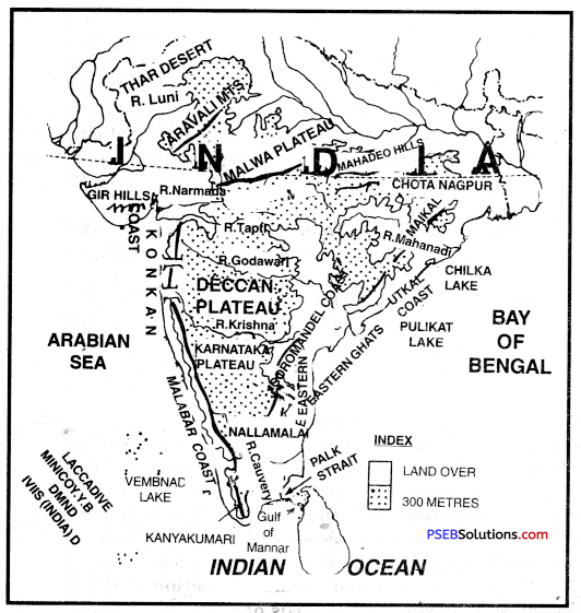
Thar Desert extends from southern borders of Punjab and Haryana to Rann of Kutch (Gujarat). It is a plain and arid area. Aravallis form its eastern boundary. It has international boundary of Pakistan in the West. It is 640 km. long and 300 km. wide. In ancient period, this region was under sea. Proofs show that this desert was once a fertile area. But due to low rainfall and deforestation it has been changed into areas of sand dunes.
![]()
Question 6.
What could be the different divisions of Indian Islands on the basis of location? Explain with examples and diagrams.
Answer:
On the basis of location, Indian islands can be divided into the following two groups:
1. Islands situated away from the coast. There are about 230 islands found in groups. Such Coral islands exist in Arabian Sea and are called Lakshdweep islands. Amandivi, Lakshdweep, Minicoy are other islands. Andaman Nicobar islands, Norcadam, Barren islands are found in Bay of Bengal.
2. Islands situated near the coast. The new moor islands Sorat, Wheeler islands are found near Ganges delta. Other islands are Bhasara, Diu, Palmbam, Mandapam, Elephanta.
Question 7.
What is the contribution of coastal plains to entire country?
Answer:
- Coastal plains are known for rice, dates, coconuts, spices, ginger, cardamoms, etc.
- It leads in international trade.
- High grade fish are caught in these coastal areas,
- Beaches along Goa, Mumbai, Tamilnadu are a great attraction for the tourists.
- Salt is prepared on the marshy areas of west coast.
Question 8.
What is the contribution of the Himalayan Region to the development of the country as a whole?
Answer:
The following is the contribution of the Himalayan region to the development of the country as a whole.
- Useful Rivers. All the important rivers such as the Ganga, the Yamuna, the Sutlej, the Brahmaputra etc. rise in the Himalayas.
- Useful Wood. On account of heavy rainfall, dense forests are found in the Himalayas. Teak, deodar and pine are some of the trees, the wood of which is of great use.
- Minerals. Many types of minerals are found in the Himalayas.
- Fruits and Tea. The slopes of the Himalayas are very favourable for the growth of various fruits and tea. Assam is known for good quality of tea.
- Fodder and Medicinal Herbs. Many varities of medicinal herbs and grasses for fodder grow over most of the parts of Himalayas.
Question 9.
How does the peninsular plateau affect the other physical region of India?
Answer:
- Peninsular India is a part of old Gondwana land. The rivers rising out of it helped in the formation of Himalayas. After that it helped in the formation of Northern plains.
- On both sides of the plateau, there are many dams. These dams provide water for irrigation to the plains and power for industries.
- The forests of this area meet the needs of the other parts of the country.
III. Differentiate between
Question 1.
(i) Distinguish between Terai and Bhabar region.
Answer:
| Terai | Bhabar |
| 1. Terai is a broad long zone south of Bhabar plain. | 1. Bhabar is a long narrow plain along the foothills. |
| 2. It is a marshy damp area covered with thick forests. | 2. It is a pebble-studded zone of porous beds. |
| 3. It is 20-30 kms wide. | 3. It is 8-16 km wide. |
| 4. Many streams re-emerge here from the Bhabar area. | 4. Streams are lost in the region due to porous rocks. |
| 5. It is suitable for agriculture. | 5. It is unsuitable for agriculture. |
![]()
(ii) Distinguish between Bangar and Khadar.
Answer:
|
Bangar |
Khadar |
| 1. The older alluvium of the high plain is called Bangar. | 1. The younger alluvium of the flood plain is called Khadar. |
| 2. This area stands above the level of the , flood plain. | 2. Flood water spreads a new layer over it every year. |
| 3. It is composed of calcarous Kankars and clay. (Dahia) | 3. It is composed of fertile alluvium. (Bet) |
IV. Answer the following questions subjectively:
Question 1.
Divide the relief of India and explain in detail any one region.
Answer:
India is divided into following physiographic divisions:
- Himalayan Ranges
- Northern Great Plains
- Peninsular India
- Coastal Plains
- Indian Islands.
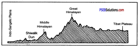
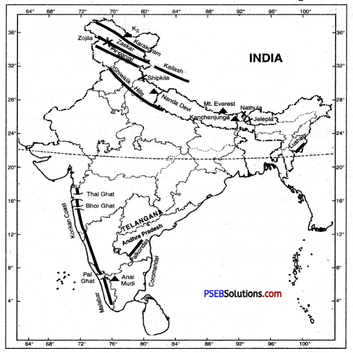
Himalayan Ranges. The Himalayas are spread over the northern boundary of India like an arc, from west to east. The length of these mountains is about 2500 kilometres and breadth is between 250 to 400 kilometres. The Mount Everest (8,848 metres) is the highest peak of the Himalayas.
The Himalayas can be divided into three parts :
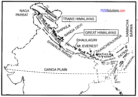
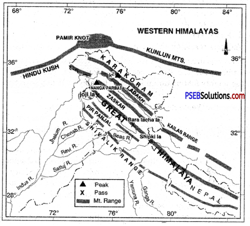
1. Northern Kashmir Himalayas. The North-western part of the Himalayas is known as the Kashmir Himalayas. Karakoram, Laddakh, Zaskar and Kailash ; are the main ranges of the Kashmir Himalayas.
2. Main Himalayas
1. Greater Himalayas or Himadri. This range spreads from East to West. Mount Everest (8,488 metres), the highest peak of the world lies in the range. Jojila, Jailpa la and Lingshi la are some of the important passes in this range.
2. The Himachal Range or Lesser Himalayas. The average height of this range is 3500 to 4500 metres and its breadth is 60 to 80 kilometres. Hill stations like Shimla, Mu^oorie and Nainital are situated on this range.
3. Shiwaliks or Outer Himalayas. The average height of these hills is 900 to 1200 metres and breadth is only 10 to 50 kilometres.
The Himalayas
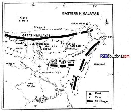
4. Off-Shoots of the Himalayas. The Himalayas turn to the south on the eastern and western flanks. They are repectively known as the Eastern and the Western Himalayas in the east and the west.
(а) Eastern Himalayas. The Himalayas consist of the famous hills of Patkoi, Naga and Manipur. They are very low hills and are fully covered with forests.
(b) Western Himalayas. In the West, Suleman and Kirthar ranges are dominant. They have many important passes like Khyber, Tochi and Bolan.
Western Himalayas
Eastern Himalayas
![]()
Question 2.
Write a note on the origin and structure of the Himalayas. Are they still rising?
Answer:
Millions of years ago, the Himalayas were occupied by a geosyncline known as Tethys. It was sandwiched between two long landmasses—Angara land on the north and Gondwana land on the south. The Tethys seas stretched over the Northern plains in east-west direction. For millions of years, sediments were deposited in Tethys sea. These sediments were folded to form the Himalayas. The land masses of Angara land and Gondwana land drifted slowly towards each other. The horizontal forces worked from two opposite directions resulting in compression. It led to sinking of the Tethys sea.
The Indian plate was driven northwards and pushed beneath the Eurasian plate. When the two plates came closer, the Tethys sea’s crust fractured. The sediments buckled and folded to form the mighty fold mountains of the Himalayas. It has been observed that the ‘Himalayas are still rising.
Question 3.
Compare the Western and Eastern coastal plains.
Answer:
|
Western Coastal Plains |
Eastern Coastal Plains |
| 1. West Coast is a narrow alluvial plain with a width of 50-80 kms.It is uneven and wet. | 1. The Eastern Coast has a wide plain with well developed delta 80 to 120 km wide. It is level and dry. |
| 2. Beautiful lagoons are found on the Malabar Coast. | 2. The Eastern Coast has only two or three lagoons. |
| 3. The short swift rivers do not make any deltas on the western Coast. The Tapti and Narmada make estuaries. | 3. The large rivers make wide deltas on the Eastern Coast. Mahanadi, Godavari, Krishana, Cauvery make well developed deltas. |
| 4. Kandla, Mumbai, Marmugao, Mangalore and Cochi are major ports on West Coast. | 4. Tuticorin, Chennai, Vishakhapatnam, Paradeep and’Kolkata are major ports on the East Coast. |
Question 4.
Give a detailed description of the size, origin and regional division of India’s Northern plains.
Answer:
Extent. The great plain extends in between the Himalayas and the Peninsular plateau. It is 3200 km long and 150 to 300 km wide. Its average height is 150 metres. It covers an area of 7.5 lakh sq. km.
Formation. It is an alluvium filled trough. It has been formed by the deposition of sediments brought from the Himalayas by the Ganga, Sutlej and other rivers.
Main Characteristics :
- It is a dead flat lowland. The maximum height above the sea level is 263 metres.
- It has a gentle gradient \(\frac{1}{4}\) metre per km.
- It has huge depth of alluvium.
- A large number of rivers flow in this plain dividing it into Doabs.
- It has fertile alluvial soils namely Khadar and Bangar soils.
Division of Northern Plain :
- Bhabar and Terai. It is a long, narrow zone along the foothills. It is a pebble- studded zone. Swampy areas occur in Terai.
- Punjab Plain. This plain has a slope in the South West direction. It has been formed by the deposition of sediments by Ravi, Beas and Sutlej rivers. Chos (seasonal streams) cause soil erosion in foothills of Shiwaliks.
- Ganga Plain. This plain has been formed by the deposition of sediments brought by the Ganga and its tributaries. It can be divided into three regions—upper Ganga plain, middle Ganga plain and the lower Ganga plain. It occupies an area of about 3.5 lakh sq. km. Sunder Ban Delta is formed in the lower Ganga plain.
- Brahmaputra Plains. These plains are situated in the Eastern part and are often known as Assam valley. The Brahmaputra river forms a large delta in Bangladesh.
The Great Indian Desert plain of the west. This covers the western part of the Aravalli mountains. This region has a sandy land, so it is also known as the Thar desert. This region gets very little rainfall, due to which the agriculture is not developed here. There are many saltwater lakes like the Sambhar, Didwana and Panchpadra, from which salt is extracted.
The formation of northern plains.
The northern plains lie in between the Himalayas and the peninsular India. It has been formed by the filling of the depression formed by Tethys sea. The Himalayan rivers after eroding the Himalayas deposited huge amount of silt and deposition in the ever-shrinking Tethys sea. This depression has been filled gradually to form northern plains or the Indo- gangetic plains. These rivers have deposited silt to form Ganga delta in Bangladesh. Due to continuous deposition, the delta is still advancing towards sea.
![]()
Question 5.
What is the extent and surface formation of the Peninsular Plateau? Describe its sub-division on the basIs”of slope of the land’.
Answer:
The Peninsular Plateau:
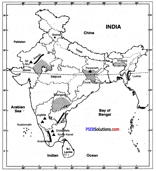
The Deccan plateau is the oldest structure of India. It is the core of the geology of India. It is surrounded by oceans on three sides. Therefore it is often called Peninsular plateau. It covers an area of 16 lakh sq. km. The average altitude of the plateau varies from 600 to 900 metres. Its limits are formed by the Aravallis in the North Rajmahal Hills and Shillong plateau in the East. There is Malda gap between Rajmahal hills and Shillong plateau. The southernmost point is known as Kanyakumari. It is an ancient, stable, hard block formed by igneous and metamorphic rocks. It was part of Gondwana land.
Division of Peninsular Plateau. A series of low hills, known as Satpura ranges between 21° N to 24° N latitudes divided the Peninsular plateau into two parts.
(a) Malwa Plateau
(b) Deccan Plateau.
(a) Malwa Plateau. The Malwa plateau covers a large part of central highlands. It extends from Aravallis in the West, Ganges valley in the North and East, and Vindhyas in the South. The Aravallis are residual mountains or Relict Mountains. Its highest peaks are Mt. Abu (1158 metres) and Guru Shikhar (1722 metres). This plateau includes Bundelkhand, Baghelkhand and Chambal valley. This Vindhyan plateau consists of long narrow ridges made up of Quartzite rocks. It extends upto Mahadeo Hills, Kaimur range, Maikal range, Rajmahal hills in the East. In the East lies Chotta Nagpur plateau drained by Damodar river. This plateau is the storehouse of minerals of India.
Vindhyas: This range extends from east to west in the north of River Narmada. It separates Northern India from Southern India. Its average height is 300 metres. It starts from Gujarat in the west and goes up to Bihar in the East passing through the Madhya Pradesh.
Satpuras: This mountain range spreads between the Narmada and the Tapti rivers. They extend from Gujarat in the west to Amarkantak in the east. Dhupgarh (1350 metres) is the highest point of these ranges.
(b) Deccan Plateau: This plateau lies South of Narmada river. It is surrounded by mountain ranges on three sides Western Ghats, Eastern Ghats and Satpuras. Narmada and Tapti valleys are rift valleys between Satpuras and Vindhyas. Karnataka Plateau lies between Eastern Ghats and Western Ghats. Deccan plateau is a tilted plateau with a general eastward slope. It covers an area of about 70 lakh sq. km. Its average height varies between 500 metres to 1000 metres.
The rivers have divided this plateau into many sub divisions. N.W. Deccan plateau is made up of lava and is known as Deccan trap.
1. the Western Ghats. The Western Ghats extend from Tapti Valley up to Kanyakumari for about 1500 kms. It has three passes Thai ghat, Bhor ghat and Pal ghat. These ranges rise abruptly from the coast. Short swift streams flow towards the west and do not form deltas. The average height is about 1200 metres. Godavari, Krishna and Cauvery rivers rise from Western ghats and flow towards East. Anai Mudi (2698 metres) is the highest peak.
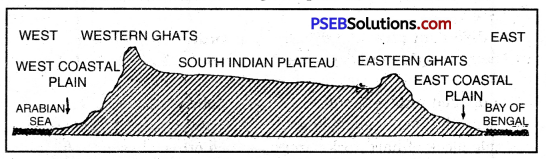
East-West Cross Profile of the South Indian Plateau
2. Eastern Ghats. Eastern Ghats extend for about 800 kms from Mahanadi valleys upto Nilgiris. These are not continuous ranges. Rivers form wide gaps. Javadi, Shevroy and Nallamalai bills are found in the Southern part.
(Hi) Nilgiris. The western and eastern Ghats join each other in the south where they are known as the Nilgiris. Doda Beta (2637 metres) is the highest peak in the Nilgiris.
Question 6.
Compare and contrast the surface features of the Himalayas and Peninsular Plateau.
Or
Cite difference between Himalayas and Peninsular Plateau comparing their physical features.
Answer:
|
The Himalayas |
Indian Plateau |
| 1. The Himalayas are young new fold mountains. | 1. The Indian plateau is an ancient crystalline table land. |
| 2. These mountains have been formed due to folding by different earth movements. | 2. This plateau has been formed’ as a Horst. |
| 3. The relief features show young age of the Himalayas. | 3. The plateau is old and well dissected. |
| 4. Parallel mountain ranges are formed in the Himalayan region. | 4. Rift valleys are formed due to faulting. |
| 5. These mountains are the loftiest mountain system of the world with the highest mountain peak Mt. Everest 8848 mts. above sea level. | 5. It is an old eroded crystal rock with the highest peak Anaimudi 2695 mts. above sea level. |
| 6. These mountains extend in an arc. | 6. This plateau is triangular in shape. |
| 7. Deep gorges and U-shaped valleys are formed. | 7. Narrow deep river valleys are formed on the plateau. |
| 8. These have been formed out of Tethys sea in Mesozoic period. (276 Million years ago.) | 8. This plateau has been lifted out of the sea in the precambrian period. (1600 million years ago.) |
| 9. It is made up of sedimentary rocks. | 9. It is made up of igneous rocks. |
Question 7.
Write short notes on:
(i) Vindhyachal
Answer:
Vindhyas: This range extends from east to west in the north of River Narmada. It separates Northern India from Southern India. Its average height is 300 metres. It starts from Gujarat in the west and goes up to Bihar in the East passing through the Madhya Pradesh.
(ii) Satpuras
Answer:
Satpuras: This mountain range spreads between the Narmada and the Tapti rivers. They extend from Gujarat in the west to Amarkantak in the east. Dhupgarh (1350 metres) is the highest point of these ranges.
(iii) Aravalli Mountains
Answer:
(iv) Malwa Plateau and
Answer:
Malwa Plateau: The Malwa plateau covers a large part of central highlands. It extends from Aravallis in the West, Ganges valley in the North and East, and Vindhyas in the South. The Aravallis are residual mountains or Relict Mountains. Its highest peaks are Mt. Abu (1158 metres) and Guru Shikhar (1722 metres). This plateau includes Bundelkhand, Baghelkhand and Chambal valley. This Vindhyan plateau consists of long narrow ridges made up of Quartzite rocks. It extends upto Mahadeo Hills, Kaimur range, Maikal range, Rajmahal hills in the East. In the East lies Chotta Nagpur plateau drained by Damodar river. This plateau is the storehouse of minerals of India.
(v) Nilgiri Hills.
Answer:
Nilgiris: The western and eastern Ghats join each other in the south where they are known as the Nilgiris. Doda Beta (2637 metres) is the highest peak in the Nilgiris.
![]()
Question 8.
Are the different physical divisions of India separate and interdependent units or are they complementary to each other? Explain this statement with examples. (Important)
Answer:
India is divided into three major physiographic division i.e. the Himalayas, the Northern plains and the Peninsular plateau. The peninsular is the core of the geology of India. It is a stable block of hard rocks around which other physiographic divisions have been formed. The northward drifting of peninsular plateau led to the formation of Himalayas. The Himalayas adorn like a crown. These enclose the Indian sub-continent. Sediments brought down from Himalayas have been deposited to form the northern plains. The Gangetic plain is the cradle of Indian civilisation. Thus three physiographic divisions help to strengthen the forces of unity of our people.
V. Show the following on the outline map of India:
Question 1.
(1) Karakoram, Zanskar, Kailash, Pir Panjal, Shiwalik Hills
(2) Coromandel, Konkan (B.Q.P. 2019), Malabar Coast.
(3) Passes of Thai Ghat, Bhor Ghat, Pal Ghat
(4) Passes of Zojila, Nathula, Jelepla, Shipkila
(5) Mt. Everest (B.Q.P. 2019), Nanda Devi, Kanchenjunga, K2.
Answer:
Question 2.
(1) Aravali, Anamailai.
(2) Mt. Abu, Shimla, Satpura.
Answer:
PSEB 10th Class Social Science Guide Land Important Questions and Answers
Answer the following questions each in one line or one word :
Question 1.
Which is the ancient block in India?
Answer:
Deccan Plateau.
Question 2.
Name the sea which existed in place of Himalayas.
Answer:
Tethys.
![]()
Question 3.
Name the western boundary of Deccan plateau.
Answer:
Aravallis.
Question 4.
Name an area where chos are found.
Answer:
Hoshiarpur.
Question 5.
Name the highest mountain peak of Peninsular India.
Answer:
Anai Mudi.
Question 6.
Name the Northern part of west-coast.
Answer:
Konkan.
Question 7.
Name a cold desert in India.
Answer:
Ladakh.
Question 8.
Name a religious place in western Himalayas.
Answer:
Vaishno Devi.
Question 9.
Where is a valley of flowers located?
Answer:
The great Himalayas.
Question 10.
What is the use of Kayals?
Answer:
Fishing.
Question 11.
Which disaster struck east coast in 2004?
Answer:
Tsunami.
Question 12.
Which is the highest peak of Himalayas located in India?
Answer:
Kanchan Junga.
Question 13.
Name a rift valley in India.
Answer:
Narmada.
Question 14.
Why is the peninsular India called the Core of structure of India?
Answer:
Peninsular India is the ancient part of India.
Question 15.
What is the meaning of Himalayas?
Answer:
Himalayas means abode of snow.
![]()
Question 16.
What is the average height of Trans Himalayas? Name four mountain ranges of these.
Answer:
The average height of Trans Himalayas is 5000. metres. It includes Zanskar, Karakoram, Ladakh, and Kailash Ranges.
Question 17.
Name the main glaciers of the Traps Himalayas.
Answer:
Hisper, Batur, Baltoro, Siachen, Bearo.
Question 18.
What is a dun?
Answer:
Dun is a longitudinal valley situated in Himalayas.
Question 19.
Name the highest peaks of Eastern offshoots of Himalayas.
Answer:
Dafa Bum (4578 meters), Saramati (8926 meters) and Japau.
Question 20.
Name the higher peak of the world and its height.
Or
Which is the highest peak of the world?
Answer:
Mt. Everest 8848 metres is the highest peak of the world.
Question 21.
State the situation of the Northern great plains.
Answer:
This plain extends between Indus River (West) and Brahmaputra River (East).
Question 22.
State two Relief characteristics of Northern great plain.
Answer:
- It is a flat plain.
- The whole plain has a network of streams.
Question 23.
Which rivers have deposited sediments in Punjab-Haryana plain?
Answer:
Sutluj, Ravi, Beas and Ghaghar.
Question 24.
According to height, into how many sub-divisions can Ganges plain be divided?
Answer:
- Upper Ganges valley
- Middle Ganges valley
- Lower Ganges valley.
Question 25.
State two characteristics of Brahmputra plain.
Answer:
- This plain is 640 km long and 90:100 km wide.
- New sediments are deposited every year by floods.
![]()
Question 26.
State the. two ranges of Deccan plateau.
Answer:
- Western ghats
- Eastern ghats
Question 27.
Name three passes of Western ghats.
Answer:
Thai ghat, Bhor ghat, Pal ghat
Question 28.
Where is Jog Falls and what is its height?
Answer:
Jog Falls is located on the border of Shimoga and Uttara Kannada districts of Karnataka. Height of Jog Falls is 253 metres.
Question 29.
State the sub-divisions of west coastal plain.
Answer:
- Gujarat coast
- Konkan coast
- Malabar coast
- Kerala coast.
Question 30.
State one difference between Eastern coastal plain and Western coastal plain.
Answer:
Eastern coastal plain is wide and flat. While west-coastal plain is narrow.
Question 31.
Which are the group of islands of India and where are they situated?
Answer:
Andaman Nicobar and Lakshdweep group of islands are situated in Bay of Bengal and Arabian Sea respectively.
Question 32.
State two differences between the mountains of northern India and mountains of Peninsular India.
Answer:
- Mountains of Northern India are young fold mountains. Mountains of peninsular India are residual old mountains.
- The mountains of northern India are high and snow covered. But the mountains of Peninsular India are not high and are not covered with glacier.
Question 33.
Which is the highest peak of the world?
Answer:
Mount Everest (8848 metres)
Fill in the blanks:
Question 1.
The Himalayas extend for ____________kms.
Answer:
2400.
Question 2.
Mt. Everest is _________ metres high.
Answer:
8848.
Question 3.
Ganges plain slopes towards________.
Answer:
East.
![]()
Question 4.
The Southern plateau has its apex at ________.
Answer:
Kanyakumari
Question 5.
Andaman group has __________ islands.
Answer:
120.
Multiple Choice Questions:
Question 1.
Which is the oldest land mass of India?
(a) Northern Plain
(b) Peninsular Plateau
(c) Himalayas
(d) Aravallis.
Answer:
(b) Peninsular Plateau
Question 2.
Which is the highest peak in southern India?
(a) Doda Beta
(b) Anaimudi
(c) Mahendar gins
(d) Kalsubai.
Answer:
(b) Anaimudi
Question 3.
Which is a rift valley?
(a) Ganga
(b) Narmada
(c) Chambal
(d) Damodar.
Answer:
(b) Narmada
Question 4.
Ravines are found in :
(a) Chambal Valley
(b) Son Valley
(c) Damodar Valley
(d) Betwa Valley.
Answer:
(a) Chambal Valley
Question 5.
The largest salt water lake in India is :
(a) Sambar
(b) Chilka
(c) Vembnad
(d) Kalleru.
Answer:
(b) Chilka
True / False :
Question 1.
The Himalayas are rift valleys formed due to faulting.
Answer:
False
Question 2.
Doda Beta is the highest peak in the Nilgiris.
Answer:
True
![]()
Question 3.
Ganga river makes estuary.
Answer:
False
Question 4.
In Indo-Gangetic plains alluvial soils are found.
Answer:
True
Question 5.
There are 550 islands in the Indian Ocean.
Answer:
True
Short Answer Tyre Questions
Question 1.
Compare and contrast the Indo-Gangetic Plains and Peninsular Plateau.
Answer:
| Peninsular Plateau | Indo-Gangetic Plains |
| 1. Location: It is a triangular plateau bounded by Vindhyas, Western ghats and Eastern ghats. | 1. It is an alluvial plain stretching from Punjab to Assam Valley. |
| 2. Relief: The relief of this plateau is uneven. Its average height above sea level is more than 600 metres. | 2. This is a level plain about 200 metres high above sea level. |
| 3. Climate: The climate here is hot and humid. | 3. Here the summers are hot and winters are cold. |
| 4. Crops: Jawar, Bajra, Spices and Groundnut are grown here. | 4. Rice, Wheat, Cotton and Sugarcane are mostly grown here. |
| 5. Rivers: Cauvery, Mahanadi, Godavari, Narmada and Tapti are the main seasonal rivers here. | 5. Ganga, Yamuna and Brahmaputra are the main perennial rivers. |
| 6. Irrigation: Irrigation here is mainly done by Tanks. | 6. Wells, Tubewells and Canals are the main sources of irrigation here. |
| 7. Transport: Means of transport are rare here. | 7. A network of Railways and roads is laid here. |
| 8. Minerals: Gold and Manganese are the main minerals of this plateau. | 8. Iron, Coal and Mica are the important minerals of these plains. |
| 9. Population: The population is very thin. | 9. The population is very dense. |
| 10. Soils: Soils are made up of lava especially black soil | 10. Alluvial soils are found. |
Question 2.
Write notes on Eastern ghats and Western ghats.
Answer:
|
Western ghats |
Eastern ghats |
| 1. The Western ghats form a continuous chain from Gulf of Cambay to Kanyakumari. | 1. The Eastern ghats form a discontinuous chain of low hills from Orissa to Coromandel coast. |
| 2. These consist of Sahyadri, Nilgiris, Annamalai and Cardamom hills. | 2. The Eastern ghats are known by local names. |
| 3. The main passes in Western ghats are Thai ghat, Bhor ghat, Pal ghat. | 3. There are wide gaps in Eastern ghats, through which rivers flow. |
| 4. The average height is 100d metres. The highest peak is Anaimuth (2965 metres) in Kerala. | 4. The average height of Eastern ghats is 450 metres. These merge with Western ghats to form a knot in Nilgiris. |
Question 3.
What is Gondwatta land? Which land masses constitute it?
Answer:
Orignially it was a super continent called Pangea consisting of two parts. The Northern part was called Angara land, while the Southern part was called Gondwana land. Gondwana land is the oldest landmass. It included India, Australia, South Africa and South America. These have changed its position due’ to drifting of continents.
Question 4.
State four main features of Himalayas.
Answer:
- The Himalayas are young, fold and loftiest mouhtains.
- These extend in a west-east direction from Indus to Brahmaputra.
- These form an arc which covers a distance of about 2400 kms. while their width varies from 400 km. in Kashmir to 150 km-in Arunachal Pradesh.
- The Himalayas consist of three, parallel ranges Himadri (Great Himalayas), Himachal (Lesser Himalayas) and Shiwaliks (Outer Himalayas).
Question 5.
Name the mountain ranged and. valleys situated in Himachal (Lesser Himalayas).
Answer:
The lesser Himalayas are called Himachal. Its altitude varies between 3,700 and 4,500 mitres. It includes the ranges of Pir Panjal, Dhaula Dhar and Mahabharat. It includes the famous valleys of Kashmir, Kangra and Kulu. This region is well-known for its hill stations.
Question 6.
‘River valleys demarcate the broad divisions of Himalayas.’ Give examples.
Answer:
The Himalayas have been divided on the basis of regions from West to East on the basis of. river valleys.
- Kashmir Himalayas: Between Indus and Satluj rivers.
- Kumaon Himalayas: Between Satluj and Kali rivers.
- Nepal Himalayas: Between Kali and Tista rivers.
- Assam Himalayas: Between Tista and Dihang rivers.
![]()
Question 7.
‘Northern plain is agriculturally a very productive part of India.’ Give reasons.
Answer:
Northern plain is called the ‘Granary of India’. It is rich in the production of food grains and crops.
- The region has fertile alluvial soils.
- It has an adequate water supply.
- It has a favourable climate with a long growing season.
Question 8.
What is the extent of Ganga plain? Name the states included in it.
Answer:
The Ganga plain extends between Ghaggar and Teesta rivers. It spreads over an area of 7 lakh sq km. It is 2400 km long and 240-320 km wide. It is spread over the the states of North India—Haryana, Delhi, U.P., Bihar, West Bangal and partly Jharkhand.
Question 9.
Describe four main features of Peninsular plateau.
Answer:
- The Peninsular Plateau is a table land composed of igneous and metamorphic rocks.
- It is the oldest land mass (a part of Gondwana land).
- The plateau has broad and shallow valleys anjd rounded hills.
- It has been formed due to breaking, weathering and drifting of Gondwana land.
- It consists of two broad divisions-Central Highlands and Deccan Plateaus.
Question 10.
Describe the different plateaus found in Central Highland.
Answer:
The peninsular plateau consists of two broad divisions-Central Highlands and Deccan Plateau. Central Highlands lie to the North of Narmada river. It includes a major area of Malwa plateau. Vindhyan range is enclosed by Aravallis and central highlands. The eastward extension of Central Highlands is Bundelkhand and Baghelkhand plateaus. Further eastwards, lies the Chota Nagpur plateau.
Question 11.
What is the average height of Western ghats? Name the local peaks and hill stations found in Western ghats.
Answer:
Western ghats are higher than Eastern ghats. The average height of Western ghats is 900-1600 metres. The height of the western ghats increases from North to South. The highest peaks include Anai Mudi (2695 meters), Doda Beta (2637 metres). The famous hill stations are Udaga Mandlam (Ooty) and Kodai Kanal.
![]()
Question 12.
What are the effects of Western ghats?
Answer:
- Western ghats cause relief rainfall along the Western slopes. These face the rain bearing moist winds. <br
- The eastern slopes and Deccan plateau lie in rain shadow.
- Due to weathering of Deccan plateau, Black soils of Deccan trap are found here.
Question 13.
What is meant by ‘Trans Himalayas’?
Answer:
The Trans Himalaya or Gangetic-Nyenchen Tanglha range is a 16,00-kilometre
long mountain range. This range is in China extending in west-east direction parallel to the main Himalayan range.
Long Answer Type Questions
Question 1.
Give an account of the coastal plains and island groups of India.
Answer:
Coastal Plains And Islands
The peninsular plateau is flanked by narrow coastal plains on the Eastern and Western margins.
1. The Eastern Coastal Plain. It extends from Mahanadi Delta upto Kanyakumari. Its width varies from 50 to 250 km. Mahanadi, Godavari, Krishna form broad deltas on this coast. Sand dunes and lagoons exist on this coast. Chilka lake and Pulicat lake are the two important lagoons. It is also known as Coromandel coast. The northern part, along the Orissa state, is known as Utkal coast.
2. The Western Coastal Plain. This is a narrow coastal plain 1500 kms long and about 10 to 50 km wide. It extends between the Arabian Sea and Western Ghats. It has three sub-divisions. Konkan coast from Gulf of Cambay to Goa, Kanara coast from Goa to Cochin, Malabar coast from Cochin to Kanyakumari. Lagoons and back waters along Malabar coast join together to form waterways. Vembnad is an important lagoon lake which is 63 km in length. Narmada and Tapti rivers make estuaries while Mumbai and Marmagao are deep natural harbours.
These plains are divided into the following parts:
(a) Gujarat coastal plain: A marshy area around Gulf of Kutch and Saurashtra. Gorakhnath is the highest peak with 1117 metres in height.
(b) Konkan coast: It extends from Daman to Goa; 500 km long and 50-80 km. wide. Mumbai port is in the Creek by Thana.
(c) Malabar coast: From Goa to Mangalore, 225 km long and 24 km wide. It extends upto Kanyakumari.
(d) Kerala coast: From Mangalore to Kanyakumari 500 km long and 100 km wide plain has lagoons and Kayals used as backwaters for boat navigation.
ISLANDS: There are about 550 islands in the Indian Ocean. Most of these islands are too small to be inhabited.
These islands are found in the following groups :
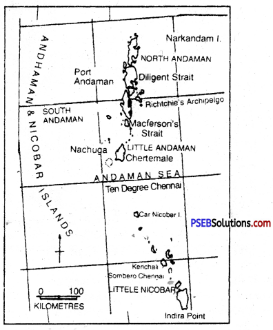
1. Andaman-Nicobar Islands: These islands form two major groups in Bay of Bengal. These are Andamans and Nicobar islands. These islands extend between 10° and 14° N latitudes for a distance of 500 kms. These islands are 214 in number. The Nicobar group consists of 15 islands extending between 6°N to 10°N latitudes. Ten degree channel separates the Andaman group of island from the Nicobar group. These islands form a union territory of India with Port Blair as its capital. Indira Point in the Nicobar-island is the southernmost point of the Indian Union. These islands form the summits of the submerged hills of the ocean floor.
The Arabian Sea Islands
2. Barren Islands and Norcondam Islands: These islands situated in the north of Port Blair are volcanic islands.
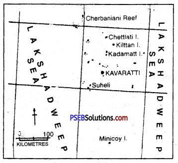
3. Lakshadweep Islands: These islands are situated in the Arabian Sea and lie 320 km off the coast of Kerala between 8° N and 12° North latitudes. These are coral islands and some of these are ring-shaped and called atolls. These are 27 in number and 17 of these are uninhabited. It is a U.T. with Kavaratti as capital. Pamban and Rameshwaram islands lie between India and Sri Lanka.
Bay of Bengal-Islands
