PSEB 6th Class Social Science Solutions Chapter 17 The Chalukyas and the Pallavas

Punjab State Board PSEB 6th Class Social Science Book Solutions History Chapter 17 The Chalukyas and the Pallavas Textbook Exercise Questions and Answers.

PSEB Solutions for Class 6 Social Science History Chapter 17 The Chalukyas and the Pallavas

SST Guide for Class 6 PSEB The Chalukyas and the Pallavas Textbook Questions and Answers

I. Answer the following questions :

Question 1.
What do you know about the Chalukyas of South India?
Answer:
The Chalukyas established their rule in South India in the early 6th century A.D. Pulakeshin-I and his son Kirtivarman were early notable kings of this dynasty. Vatapi (modern Badami) in District Bijapur of Karnataka was their capital city. The most famous and strong king’of this dynasty was Pulakeshin-II. He wanted to establish his rule over the whole of the Deccan. He achieved some success in the beginning. He conquered several areas in South India and defeated the Pallavas of Tamil Nadu. He defeated great king Harshavardhana near the river Narmada. But he was defeated by the Pallava king Narasimhavarman-I. This was a big defeat for the Chalukyas. Pulakeshin-II died in 642 A.D. His successors were inefficient and they failed to control the empire. In the middle of the eighth century, the Rashtrakutas defeated them, and ended their rule.

Question 2.
Write a note about the temples of the Chalukyas.
Answer:
The Chalukyas were great lovers of art. They constructed several famous temples at.Aihole, Vatapi and Pattadkal. The Virupaksha and the Pampanatha temples were the most famous. These temples were dedicated to Brahma, Vishnu and Shiva. They had beautiful panels of scenes from the Ramayana. The Chalukyas also got beautiful cave temples built at Vatapi (Badami). These temples are known for their artistic carvings. Most of the sculptures found at Ellora were due to the patronage of the Chalukyas.

PSEB 6th Class Social Science Solutions Chapter 17 The Chalukyas and the Pallavas

Question 3.
What do you know about the Pallavas?
Answer:
The Pallavas were officers of the Satavahanas. When the Satavahana kings became weak, they strengthened their position and captured power. They gradually expanded their state towards the region of Kanchipuram near Chennai in Tamil Nadu. They had to fight many wars against the Pandyas and the Chalukyas. They conquered regions south of Kanchipuram, Tanjore and Puddukottai.

Mahendravarman-I was a famous king of the Pallava dynasty. He was involved in a long struggle with the Chalukya ruler Pulakeshin-II. He was not just a warrior but also a poet and a musician. His son Narasimhavarman-I was also a great warrior. He defeated the Chalukyas and thus avenged the defeat of his father. He also sent two expeditions against Sri Lanka and came out victorious.

The Pallavas were locked in a long struggle with the Cholas. Ultimately, they were defeated and ousted in the 9th century A.D.

Question 4.
Write about the art and architecture of the Pallavas.
Answer:
The Pallavas were great patrons of art and architecture. They were deeply interested in temple building. They got several temples constructed. Some of them were cut out of large rocks such as the Ratha Temples at Mahabalipuram. The Ratha Temples are named after the’ Pandavas of the Mahabharata. Another Pallava temple at Mahabalipuram is known as the Shore Temple. At their capital city Kanchipuram the Pallavas constructed the famous Kailashanath Temple. Besides the sculptures of gods and goddesses, statues of the Pallava kings and queens were»also built in these temples.

The Pallavas also patronised music, dance and painting.

II. Fill in the blanks :

Question 1.
_______ and _______ were the famous kings of the Chalukyas.
Answer:
Pulakeshin I

Question 2.
Chalukya rulers were the famous patrons of _______
Answer:
Kirtivarman art

Question 3.
_______ founded the Pallava dynasty.
Answer:
Simhavishnu

PSEB 6th Class Social Science Solutions Chapter 17 The Chalukyas and the Pallavas

Question 4.
Pallavas had their capital at _______ near Chennai in Tamil
Answer:
Kanchi,

Question 5.
Pallavas were great patrons and lovers of _______ and _______
Answer:
art, architecture

Question 6.
Pallava rulers were mainly followers of _______ and _______
Answer:
Jainism, Saivism.

III. Match the columns :

Question 1.

A B
(1) Persian ambassador (a) Chalukya temple
(2) Virupaksha (b) Pulakeshin II
(3) Mahabalipuram (c) Pallava king
(4) Mahendravarman (d) The Ratha temple.

Answer:
Correct columns :

A B
(1) Persian ambassador (b) Pulakeshin II
(2) Virupaksha (a) Chalukya temple
(3) Mahabalipuram (d) The Ratha temple.
(4) Mahendravarman (c) Pallava king

IV. Write ‘true’ or ‘false’ in the brackets given after each statement :

Question 1.
Pulakeshin-II fought with Harshavardhana.
Answer:
True

PSEB 6th Class Social Science Solutions Chapter 17 The Chalukyas and the Pallavas

Question 2.
Aihole and Pattadkal are known for the seashore.
Answer:
False

Question 3.
Kanchipuram was the capital of the Chalukyas.
Answer:
False

Question 4.
Kailashanath temple was built by the Pallavas.
Answer:
True.

V. Activity (Something To Do) :

Question 1.
Collect pictures of the famous rock-cut temples of South India.
Answer:
Do it yourself.

PSEB 6th Class Social Science Guide The Chalukyas and the Pallavas Important Questions and Answers

Multiple Choice Questions

Question 1.
Which was the capital Chalukyas?
(A) Madwari
(B) Varanasi
(C) Aithole
(D) Kanaj.
Answer:
(C) Aithole.

Question 2.
Who was the best chalukya ruler?
(A) Vijayaraja I
(B) Vijayraja II
(C) Samudragupta
(D) Pulakeshin II.
Answer:
(D) Pulakeshin II.

PSEB 6th Class Social Science Solutions Chapter 17 The Chalukyas and the Pallavas

Question 3.
_______ was the court poet of Pulakeshin II?
(A) Ravikirti
(B) Xuan Zang
(C) Banabhatta
(D) Harishana.
Answer:
(A) Ravikirti.

Question 4.
After the decline of kingdom, the Chalukyas and Pallavas emerged in south India.
(A) Rashtrakuta
(B) Satavahana
(C) Pala
(D) Chera
Answer:
(B) Satavahana.

Question 5.
Mahendravarman-I was a powerful king of _______ dynasty
(A) Satavahana
(B) Chera
(C) Pallava
(D) Chola.
Answer:
(C) Pallava.

Question 6.
Ratha Temple at Mahabalipuram was made under _______dynasty.
(A) Pallava
(B) Chera
(C) Satavahana
(D) Chola.
Answer:
(A) Pallava.

PSEB 6th Class Social Science Solutions Chapter 17 The Chalukyas and the Pallavas

Question 7.
Pallavas were ousted by the __________
(A) Cheras
(B) Cholas
(C) Rashtrakutas
(D) Palas.
Answer:
(B) Cholas.

Very Short Answer Type Questions

Question 1.
Name the capital city of the Chalukyas.
Answer:
Vatapi (Badami).

Question 2.
Who was the most powerful ruler of the Chalukya dynasty?
Answer:
Pulakeshin-II.

Question 3.
Name the ruler of the Pushyabhuti dynasty who was defeated by Pulakeshin-II.
Answer:
Harshavardhana.

Question 4.
Name the Chinese traveller who visited the kingdom of Pulakeshin-II.
Answer:
Hiuen Tsang.

Question 5.
When did Pulakeshin-II die?
Answer:
Pulakeshin-II died in 642 A.D.

Question 6.
Name the most famous temples constructed by the Chalukyas.
Answer:
The Virupaksha and the Pampanatha.

PSEB 6th Class Social Science Solutions Chapter 17 The Chalukyas and the Pallavas

Question 7.
Where did the Pallavas rule?
Answer:
The Pallavas ruled in Tamil Nadu and parts of Andhra Pradesh.

Question 8.
Who defeated the Pallava king Vishnugopavarman?
Answer:
The Gupta ruler Samudragupta defeated Vishnugopavarman.

Question 9.
When and by whom was a new Pallava dynasty established?
Answer:
A new Pallava dynasty was established in the last quarter of the 6th century A.D. by Simhavishnu.

Question 10.
Who ousted the Pallavas and when?
Answer:
The Cholas ousted the Pallavas in the 9th century A.D.

Question 11.
Who were Alwars and Nayannars?
Answer:
The Alwars were the devotees of Vishnu and Nayannars were the devotees of Shiva.

Question 12.
Who built the Ratha Temple at Mahabalipuram?
Answer:
The Pallavas.

PSEB 6th Class Social Science Solutions Chapter 17 The Chalukyas and the Pallavas

Question 13.
Name the two important enemies of the Chalukyas.
Answer:
The Rashtrakutas in the north and the Pallavas in the south were the two important enemies of the Chalukyas.

Question 14.
Besides religious centres, what other functions were performed in the Pallava temples?
Answer:
Besides religious centres, the Pallava temples were also centres of social activities and education.

Question 15.
Name two important books written during the Pallava period.
Answer:
Manimekhalai and Shilpadikaram.

Short Answer Type Questions

Question 1.
Who was Hiuen Tsang? About which state did he write his account?
Answer:
Hiuen Tsang was a Chinese traveller who visited India during the reign of Pulakeshin-II of the Chalukya dynasty. Then the Chalukya kingdom was at its height. Hiuen Tsang wrote an account about the life, administration and economic and religious conditions of the Chalukya state.

Question 2.
What do you know about the Pallava king Narasimhavarman-I?
Answer:
The Pallava king Narasimhavarman-I was a powerful ruler. He defeated Pulakeshin-II of the Chalukya dynasty. He also made several other victories and expanded his empire. He fought battles against the Pandya, Chera and Chola kings. He sent two expeditions against Sri Lanka and was successful. He made Kanchipuram his capital city.

PSEB 6th Class Social Science Solutions Chapter 17 The Chalukyas and the Pallavas

Question 3.
Write a brief note on the religion of the Pallava age.
Answer:
The Pallava kings were mainly followers of Jainism and Shaivism. But they adopted the policy of religious tolerance. They respected all religions. Hiuen Tsang visited the Pallavas’ capital city Kanchipuram in 642 A.D. He writes that Buddhism, Jainism, and Hinduism flourished side by side in the Pallava kingdom.

Question 4.
How is the age of the Pallavas of Kanchi memorable?
Answer:
The age of the Pallavas of Kanchi is memorable in the political and cultural history of India. The Pallavas established a great empire. Kanchi became a great centre of Brahminical as well as Buddhist learning. Many of the Vaishnav Alwars and Shaiva Nayannars flourished during the rule of the Pallavas of Kanchi.
PSEB 6th Class Social Science Solutions Chapter 16 The Period of Harshavardhana (600 – 650 A.D.)

Punjab State Board PSEB 6th Class Social Science Book Solutions History Chapter 16 The Period of Harshavardhana (600 – 650 A.D.) Textbook Exercise Questions and Answers.

PSEB Solutions for Class 6 Social Science History Chapter 16 The Period of Harshavardhana (600 – 650 A.D.)

SST Guide for Class 6 PSEB The Period of Harshavardhana (600 – 650 A.D.) Textbook Questions and Answers

I. Answer the following questions :

Question 1.
What do you know about Hiuen Tsang?
Answer:
Hiuen Tsang: Hiuen Tsang was a famous Chinese traveller who visited India during the reign of Harshavardhana. He was the royal guest in Harsha’s court. He spent nearly 15 years in India. He wrote about India and her people in detail.

Question 2.
Write a note about Harshavardhana.
Answer:
Harshavardhana was the most important ruler of the Pushyabhuti dynasty. His brother Rajyavardhana and his sister’s husband Grahavarman who was the ruler of Maukhari, were assassinated by Shashanka, the king of Bengal, with the help of the king of Malwa. Therefore, Harshavardhana ascended the throne in 606 A.D., after the death of his brother.

After ascending the throne Harshavardhana moved his capital from Sthaneshwar to Kannauj and became the joint ruler of both (Pushyabhuti and Maukhari) the states. He vowed to take revenge of the death of his brother and sister’s husband. After a few years he killed Shashanka and thus conquered Bengal. He conquered several other territories also and became the most powerful ruler of North India. He also led a military campaign against Pulakeshin- II of Chalukya dynasty of South India but failed.

Harshavardhana was a great scholar. He wrote three plays in Sanskrit, namely Priyadarshika, Ratnavali and Nagananda.

Harshavardhana was a follower of Shaivism but he respected other faiths also. He had special respect for Buddhism. He convened an assembly of Buddhists at Kannauj under the chairmanship of Hiuen Tsang. He also held assemblies at Allahabad after every five years. In one such assembly he is said to have given away all his wealth in charity.
Harshavardhana passed away in about 647 A.D. and with his death the rule of the Pushyabhuti dynasty also ended.

Question 3.
What do you know about the society of this period?
Answer:
The caste system was in existence in India during Harshavardhana’s period. The untouchables were treated badly. They had to live outside the towns. The houses of rich people were beautifully built. On the other hand, the poor lived in small houses having mud floors. The dress of the people varied from region to region. The people were honest and lovers of freedom. They loved and respected each other. Most of the people were vegetarians. There were not many criminals. The Hinduism was much popular among the people, whereas the Buddhism was less popular among them.

PSEB 6th Class Social Science Solutions Chapter 16 The Period of Harshavardhana (600 - 650 A.D.)

Question 4.
Write about the administration of Harshavardhana.
Answer:
Harshavardhana was supreme in his empire. He himself made a visit of empire in order to know about the problems and difficulties of his people.There was a council of ministers to help him in administration. He himself appointed the ministers. The entire empire was divided into provinces, districts and villages. Villages were administered by Panchayats. Justice was imparted to all. Judicial system was efficient. Punishments were rigorous. Land revenue was the main source of income of the state. It was 1/ 6th of the produce and paid both in cash and kind.

II. Fill in the blanks :

Question 1.
Harshavardhana made ________ his capital.
Answer:
Kanauj

Question 2.
________ a faftious Chinese visited India during the reign of Harshavardhana.
Answer:
Hsuan Tsang

Question 3.
An account of Hashavardhana tells us that he donated the income of about ________ villages for Nalanda University.
Answer:
200

III. Match the columns :

Question 1.

A B
(1) Pushyabhutis (a) Writer
(2) Hiuen Tsang (b) Khurtkshetra
(3) Banabhatta (c) Chinese traveller
(4) Dutaka (d) Messenger

Answer:
Correct columns:

A B
(1) Pushyabhutis (b) Khurtkshetra
(2) Hiuen Tsang (c) Chinese traveller
(3) Banabhatta (a) Writer
(4) Dutaka (d) Messenger

IV. Write ‘true’ or ‘false’ in the brackets given after each statement :

Question 1.
Harshavardhana ascended the throne in, 606 A.D.
Answer:
True

PSEB 6th Class Social Science Solutions Chapter 16 The Period of Harshavardhana (600 - 650 A.D.)

Question 2.
Pulakeshin-II was the king of Bihar.
Answer:
False.

Question 3.
People did not pay any taxes to the king.
Answer:
False.

Question 4.
Most of the people were vegetarians.
Answer:
True

Question 5.
Rajyavardhana was the father of Harsha.
Answer:
False.

V. Activities (Something To Do):

Question 1.
Draw a sketch map of India and indicate Thanesar, Kanauj, Nalanda, Vatapi, Ellora on it.
Answer:
Do it yourself.

PSEB 6th Class Social Science Guide The Period of Harshavardhana (600 – 650 A.D.) Important Questions and Answers

Multiple Choice Questions:

Question 1.
The rule of Harshavardhana was around ________ years ago.
(A) 1400
(B) 1500
(C) 1600
(D) 1700.
Answer:
(A) 1400.

PSEB 6th Class Social Science Solutions Chapter 16 The Period of Harshavardhana (600 - 650 A.D.)

Question 2.
Who among the following wrote a about Hershavardhana?
(A) Banabhatta
(B) Xuna Zang
(C) Ravi Kirti’
(D) All of these.
Answer:
(D) All of these.

Question 3.
Harshacharitta was written by ________
(A) Harishana
(B) Banabhatta
(C) Arya Bhatta
(D) Xuan Zangt
Answer:
(B) Banabhatta.

Question 4.
________ dynasty rose in northern India after the decline of the Gupta empire.
(A) Pushyabhuti
(B) Mauryan
(C) Kushana
(D) Slave.
Answer:
(A) Pushyabhuti.

Question 5.
________ was the most important ruler of the Pushyabhuti dynasty.
(A) dynasty
(B) Harshavardhana
(C) Ashoka
(D) Bindusara.
Answer:
(B) Harshavardhana.

Question 6.
Shashanka was the king of ________
(A) Bengal
(B) Bihar
(C) Bengal
(D) Tamil Nadu.
Answer:
(A) Bengal.

Question 7.
Hiuen Tsang visited India during the times of.
(A) Ashoka
(B) Harshavarardhaka
(C) Sheshanka
(D) Chandragupta II.
Answer:
(B) Harshavardhana.

Question 8.
Nalanda is situated in
(A) Bengal
(B) Odisha
(C) Bihar
(D) Tamil Nadu.
Answer:
(C) Bihar

PSEB 6th Class Social Science Solutions Chapter 16 The Period of Harshavardhana (600 - 650 A.D.)

Question 9.
Which of these play was written by Harshavardhana?
(A) Priyadarshika
(B) Rathavali
(C) Nagananda
(D) All of these.
Answer:
(D) All of these.

Very Short Answer Type Questions

Question 1.
Name some of the states that rose in Northern India after the decline of the Gupta Empire.
Answer:
The Maukharis of Kannauj, the later Guptas of Magadha, the Maitrakas in Gujarat and Shashanka in Bengal.

Question 2.
Where did the Pushyabhutis start their rule?
Answer:
The Pushyabhutis started their rule in the region of Kurukshetra in the present day Haryana.

Question 3.
Name the capital city of the Pushyabhuti dynasty.
Answer:
Sthaneshwar (Thanesar).

Question 4.
Who was the most important ruler of the Pushyabhuti dynasty?
Answer:
Harshavardhana.

Question 5.
Where and why did Harshavardhana change his capital?
Answer:
Harshavardhana changed his capital from Sthaneshwar to Kannauj. He believed that Kannauj was a central place to rule whole of India.

Question 6.
Who wrote biography of Harshavardhana?
Answer:
Banabhatta.

Question 7.
Name the South Indian ruler who defeated Harshavardhana.
Answer:
Pulakeshin-II.

PSEB 6th Class Social Science Solutions Chapter 16 The Period of Harshavardhana (600 - 650 A.D.)

Question 8.
What was Harshavardhana’s religion?
Answer:
Shaivism.

Question 9.
Name the plays written by Harshavardhana.
Answer:
Priyadarshika, Ratnavali and Na

Question 10.
When did Harshavardhana die?
Answer:
In about 647 A.D.

Question 11.
What was the effect of Harshavardhana’s death on his kingdom?
Answer:
His kingdom was divided into several smaller units which kept fighting with one another.

Question 12.
From where do we come to know about Harsha-vardhana’s period?
Answer:
From Hiuen Tsang’s accounts and Banabhatta’s Harshachrita.

Short Answer Type Questions

Question 1.
Name the kings defeated by Harshavardhana. Did he conquer the kings of the Deccan?
Answer:
Harshavardhana defeated the kings of Punjab, Eastern Rajasthan and Assam. He ruled over almost the whole of North India.

After he had taken over Northern India under his control, he launched several campaigns against the Deccan rulers. But he did not conquer the Deccan. He was stopped by the army of Pulakeshin- II of the Chalukya dynasty.

PSEB 6th Class Social Science Solutions Chapter 16 The Period of Harshavardhana (600 - 650 A.D.)

Question 2.
What was Harshavardhana’s religion? How did he behave towards other religions?
Answer:
Harshavardhana was a follower of Shaivism but he bestowed his patronage on other religions as well. At Prayag he held a great assembly. He followed a tolerant religious policy. He r generously gave gifts to the Brahamanas as well as to Jains.

Question 3.
How did Hiuen Tsang describe the people of Indip?
Answer:
Hiuen Tsang described the people of India as hot tempered and quick to anger but honest. Indians were also particular about cleanliness. Except for some robberies, there were not many crimes, There was no death sentence.

Question 4.
What do you know about the economy of Harshavardhana’s period?
Answer:
In Harshavardhana’s time, agriculture was the main occupation of people. Cattle rearing was also done. Trade and carftsmanship were other occupations. People paid taxes regularly to the king both in cash and kind.

Long Answer Type Question

Question 1.
Describe the achievements of Harshavardhana as a ruler.
Answer:
Harshavardhana became the king of Sthaneshwar at the age of sixteen. He soon gathered the courage and ability to establish one of the largest kingdoms of his time.

His achievements can be described as under :
1. A Great Conquerer: Harshavardhana conquered the five kingdoms of the North, namely Punjab, Kannauj, Bengal, Bihar, and Orissa. However, he was defeated by Pulakeshin-II of the Chalukya dynasty.

2. A Great Ruler: Harshavardhana administered his empire efficiently. Taxes were reasonable. Punishments were severe. He also kept a strong army. He acted on the advice of his ministers.

3. A Patron of Literature: Harshavardhana was a great patron of literature. Banabhatta was one of his court poets. He wrote Harsha’s biography, Harshachrita. Harshavardhana himself was a great scholar. He wrote three plays in Sanskrit, namely Ratnavali, Nagananda, and Priyadarshika.

4. Religious Tolerance: Harshavardhana was a follower of Shaivism but he respected all other religions also. He had special respect for Buddhism. He convened an assembly of Buddhists at Kannauj. In the Prayag Assembly, he worshipped the Buddha, the Sun, and Shiva.

PSEB 6th Class Social Science Solutions Chapter 15 The Gupta: Empire

Punjab State Board PSEB 6th Class Social Science Book Solutions History Chapter 15 The Gupta: Empire Textbook Exercise Questions and Answers.

PSEB Solutions for Class 6 Social Science History Chapter 15 The Gupta: Empire

SST Guide for Class 6 PSEB The Gupta: Empire Textbook Questions and Answers

I. Answer the following questions :

Question 1.
Write about the conquests of Samudragupta.
Answer:
Samudragupta was a great conqueror. His conquests can be described as under :

  1. Samudragupta first of all defeated three North Indian kings of Aryavarta, namely Nagsen, Achyut and king of the Kot dynasty.
  2. While Samudragupta was busy in the South, Nagsen, Achyut and other kings of North raised a joint front against him. Samudragupta defeated all the kings of this front.
  3. He defeated twelve kings of the South. But he did not annex their territories to his kingdom. He returned their kingdoms to them after their acceptance of his subordination.
  4. Some jungle tribes of Orissa created a disturbance in his area. He defeated these tribes and established peace.
  5. He annexed the areas captured by him in the North but returned the areas in the South to their rulers. He collected taxes from these rulers.

Question 2.
What do you know about Chandragupta Vikrama- ditya?
Answer:
Chandragupta, Vikramaditya was the son of Samudragupta. He is also known as Chandragupta-II. He conducted a victorious campaign in Western India against the Shakas who had been troubling the Guptas. He also maintained friendly relations with the kings of the Deccan and the South by marital alliances. The most important of such marital alliances was with the Vakataka kingdom of the Deccan.

Chandragupta Vikramaditya is best remembered for his patronage of learning and art. He had in his court some of the wisest and most learned men of the country, known as the ‘Nine Gems’. He was a devotee of Vishnu but respected all other religions. He issued a large number of coins in gold, silver and copper. A Chinese traveller Fa-hein came to India in his time. He adopted the title of Vikramaditya that means ‘Sun of Valour’.

PSEB 6th Class Social Science Solutions Chapter 15 The Gupta: Empire

Question 3.
Write a note on Kalidasa.
Answer:
Kalidasa was the most famous among ‘Nine Gems’ in Chandragupta Vikramaditya’s court. He was a famous Sanskrit poet. He wrote books on various subjects in Sanskrit. He had written the world famous books Kumar Sambhava, Raghuvamsa, Meghaduta and Abhigyan Shakuntalam. Abhigyan Shakuntalam is famous all over the world.

Question 4.
What do you know about economic life during the Gupta period?
Answer:
The economic life during the Gupta period was very prosperous.

  1. Taxes were light and the articles of daily need were cheap. The common people used only cowries or copper coins to buy these articles. The largest number of gold coins were issued during this period. Such coins were called Dinaras.
  2. Agriculture was the main profession of the people. Besides food crops of various types, fruits and oil seeds were also grown.
  3. Both internal and external trade were developed. India had trade relations with South-East Asia, China, Central Asia and the European countries.
  4. There were unions of bankers, merchants and manufacturers, known as guilds.
  5. Cattle rearing and artisanship were other famous professions.

Question 5.
Why is the Gupta period called the Golden Age of India?
Answer:
The Gupta period was very advanced in every sphere of life. That is why it is called the Golden Age of India.

  1. The people enjoyed a period of peace and prosperity. They enjoyed a high standard of living.
  2. Both inland and international trade was carried on. Trade with other countries brought a lot of wealth and the people became rich and prosperous.
  3. There was. great advancement in the field of education.
  4. The people were honest and devoted to religion.
  5. Caste system prevailed. But the different sections of the people lived in harmony.
  6.  Though the Gupta rulers were patrons of Hinduism, yet they showed tolerance towards other religions. Buddhism was allowed to flourish.
  7. There was a great development in literature. Nine learned men known as ‘Nine Gems’ adorned the Gupta court.
  8. Art and architecture were encouraged. Several pillars of artistic beauty and a number of temples were built.
  9. Science and technology made tremendous progress. Two of the famous scientists of this age were Aryabhatta and Varahamihira. Both of them were astronomers and mathematicians.
  10. Indian culture and civilisation spread in foreign lands in the Gupta period.

II. Fill in the blanks :

Question 1.
Samudragupta was a great ________ and ________
Answer:
great warrior, ruler

Question 2.
Chandragupta II issued a very large number of coins in ________ and ________
Answer:
gold, silver, copper

Question 3.
Gupta empire was divided into many provinces which were called ________
Answer:
Bhakti

PSEB 6th Class Social Science Solutions Chapter 15 The Gupta: Empire

Question 4.
The districts were called ________
Answer:
Vishayas

Question 5.
________and ________ poem written by Kalidasa are very famous.
Answer:
Sakuntala, Meghaduta.

III. Match the columns :

Question 1.

A B
(1) Aryavarta (a) Punjab
(2) Madrakas (b) Northern India
(3) Iron Pillar (c) Officers
(4) Kumaramatyas (d) Delhi

Answer:
Correct columns :

A B
(1) Aryavarta (b) Northern India
(2) Madrakas (a) Punjab
(3) Iron Pillar (d) Delhi
(4) Kumaramatyas (c) Officers

IV. Write ‘true’ or ‘false’ in the brackets given after each

Question 1.
Maharaja Gupta was the first Gupta king.
Answer:
True

Question 2.
Vikramaditya was the title of Samudragupta.
Answer:
False

Question 3.
Yaudheyas were ruling in South India.
Answer:
False

Question 4.
Fa-hein was a Greek writer.
Answer:
False

PSEB 6th Class Social Science Solutions Chapter 15 The Gupta: Empire

Question 5.
Guptas issued gold coins.
Answer:
True

Question 6.
Aryabhatta was a famous scientist.
Answer:
True

V. Activities (Something To Do) :

Question 1.
Show the extent of the Gupta empire on the map of India.
Answer:
Do it yourself.

Question 2.
Collect pictures of the works of the art of Gupta age and paste them in your scrapbook.
Answer:
Do it yourself.

PSEB 6th Class Social Science Guide The Gupta: Empire Important Questions and Answers

Multiple Choice Questions

Question 1.
Who founded the Gupta empire?
(A) Maharaja Gupta
(B) Samundragupta
(C) Chandragupta
(D) Chandragupta II.
Answer:
(A) Maharaja Gupta.

PSEB 6th Class Social Science Solutions Chapter 15 The Gupta: Empire

Question 2.
Who is known as the greatest conqueror of the Gupta Dynasty?
(A) Sri Gupta
(B) Samudragupta
(C) Maharaja Gupta
(D) Chandragupta.
Answer:
(B) Samudragupta.

Question 3.
Horse sacrifice means
(A) Ashvashodha
(B) Ashvashloka
(C) Ashvamedha
(D) None of those.
Answer:
(C) Ashvamedha.

Question 4.
Chandragupta Vikramaditya was the son of
(A) Samudragupta
(B) Sri Gupta
(C) Chandragupta II
(D) Maharaja Gupta.
Answer:
(A) Samundragupta.

Question 5.
Fa-hein was a Chinese traveller who visited India during empire.
(A) Mughal
(B) Mavryan
(C) Gupta
(D) Kushana.
Answer:
(C) Gupta.

Question 6.
Shakuntala and Meghaduta were written by
(A) Chanakya
(B) Kalidasa
(C) Charaka
(D) Arujabhatta.
Answer:
(B) Kalidasa.

Question 7.
Aryabhata was a famous of the Gupta period.
(A) Scientist
(B) Mathematician
(C) Astronomer
(D) All of these.
Answer:
(D) All of these.

Question 8.
Chandragupta issued many coins of ________
(A) Gold
(B) Silver
(C) Copper
(D) All of these.
Answer:
(D) All of these.

PSEB 6th Class Social Science Solutions Chapter 15 The Gupta: Empire

Question 9.
Abhigyan Shakuntalam was written by
(A) Tulsidas
(B) Kalidas
(C) Aryabhatta
(D) Varahamihira.
Answer:
(B) Kalidas.

Very Short Answer Type Questions

Question 1.
Who was the first great king of the Gupta dynasty?
Answer:
Chandragupta-I.

Question 2.
For how long did Samudragupta rule?
Answer:
Samudragupta ruled for about thirty-five years.

Question 3.
Who was Harishena?
Answer:
Harishena was a court poet of Samudragupta. He recorded a detailed account of Samudragupta’s achievements on a stone pillar at Allahabad.

Question 4.
Which was the biggest conquest of Chandragupta-II, and why?
Answer:
The biggest conquest of Chandragupta-II was over the Sakas of Western India. It brought an end to the foreign rule in India.

Question 5.
Who was Skandagupta?
Answer:
Skandagupta was the grandson of Chandragupta-II. He ruled from 454 A.D. to 467 A.D.

Question 6.
Who were Uparikas?
Answer:
The Governors of provinces in the Gupta administration were called Uparikas or Maharajas.

PSEB 6th Class Social Science Solutions Chapter 15 The Gupta: Empire

Question 7.
Name the capital of the Guptas.
Answer:
Patliputra.

Question 8.
What were Dinaras?
Answer:
Dinaras were the gold coins issued by the Gupta kings.

Question 9.
Name some famous writers of the Gupta period.
Answer:
Kalidasa, Amarasimha, Sudraka, Dandin, etc.

Question 10.
Where are the world famous Ajanta Caves situated?
Answer:
The world famous Ajanta Caves are situated near Aurangabad in Maharashtra.

Question 11.
What is meant by Ashvamedha?
Answer:
The meaning of Ashvamedha is a horse sacrifice. Ashvamedha was a symbol of universal rule.

Question 12.
What, were Bhuktis and Vishayas?
Answer:
Provinces within Gupta administration were called Buktis and districts within Gupta administration were known as Vishayas.

Question 13.
Who was Fa-hein?
Answer:
Fa-hein was a Chinese traveller who came to India in the Gupta period and wrote an account of his stay in India.

Short Answer Type Questions

Question 1.
What is the main source of our information about Samudragupta’s conquests?
Answer:
The main source of our information about Samudragupta’s conquests is an inscription engraved on a pillar at Allahabad. This inscription has been written by Harishena and it describes Samudragupta’s achievements and conquests.

Question 2.
Who were Hunas? How did they affect the Gupta’s kingdom?
Answer:
The Hunas was a savage tribe that lived in Central Asia. Stories about India’s wealth attracted them, and they attacked the northern border of India in the fifth cenutury A.D. Their first invasion was repulsed by Skandagupta. But soon after they conquered Punjab and Kashmir. Their invasions shook the Gupta Empire which soon fell into pieces.

Question 3.
What does Fa-hein write about the society in the Gupta period?
Answer:
Fa-hein was a Chinese traveller, who visited India during the rule of Chandragupta-II. He writes that in the Gupta period, people were happy and honest. There was no crime or theft. People did not even lock their houses when going out. Taxes were light. Most of the people were vegetarians. The caste system had become rigid and one could not change one’s caste.

Question 4.
Name the countries with which India had trade and cultural relations in the Gupta period.
Answer:
In the Gupta period, India had trade and cultural relations with the countries of South-East Asia, such as Myanmar, Thailand, Malaysia, Vietnam, Indonesia, etc. India had trade relations even with China and Central Asian and the European countries.

PSEB 6th Class Social Science Solutions Chapter 15 The Gupta: Empire

Question 5.
Describe the achievements of the Gupta period in science and technology.
Answer:
There was an advance in science and technology in the Gupta period.

  • Aryabhatta and Varahamihira made new discoveries. Aryabhatta wrote Aryabhattiyam. He explained that the earth moves around the sun. He also told how solar and lunar eclipses occur.
  • Indian mathematicians used the decimal system and knew about zero.
  • Books on medicines and other sciences were also written during this period.

Long Answer Type Questions

Question 1.
Describe the administration of the Guptas.
Answer:
The administration of the Guptas can be described in the following ways :

  • The king was the highest authority. He administered the country with the help of ministers and several high officials.
  • The empire was divided into provinces. The provinces were called Bhuktis and were governed by officials called Uparikas or Maharajas.
  • The provinces were divided into districts, known as Vishayas.
  • The districts were further divided into cities and towns.
  • The punishments were not severe.
  • The officials were allotted jagirs instead of cash salaries during the later period of the Guptas.

Question 2.
Describe the achievements of India in the field of art and literature during the Gupta period.
Answer:
The Guptas were great patrons of art and literature. They paid great attention to the development of art and literature in India.
1. Art. Mathura became the famous centre of art during the Gupta period. It produced the most beautiful statues of the Buddha, Jain and Hindu gods and goddesses. Sarnath near Varanasi in Uttar Pradesh was also famous for good sculptures. Many beautiful temples were also made. The temples of Deogarh in Madhya Pradesh and Bhitari near Kanpur are very famous. The world-famous Ajanta Caves near Aurangabad in Maharashtra, with beautiful paintings in them, were also made. The kings made these caves for the residence and worship of the Buddhist monks. The famous Stupa of Sanchi was also rebuilt.

2. Literature. Best pieces of literature were produced during the Gupta period. The famous Sanskrit poet Kalidasa wrote several dramas and poems. His play Shakuntala and his poem Meghaduta are very famous, Other writers of the Gupta period were Amarasimha, Sudraka, Dandin, etc.

Question 3.
Give a brief description of the progress of science and technology under the patronage of the Guptas.
Answer:
Science and technology made huge progress under the patronage of Gupta rulers. “Aryabhata was the famous scientist of this age and he wrote a book called Aryabhattiyam”. In this book, he wrote that the earth moves around the sun and how solar and lunar eclipses occur. In the field of mathematics, the use of decimal systems was also given by this period. Arabs borrowed it from India and then Europeans borrowed it from Arabs. A number of books on astronomy, mathematics, and other sciences were written in this age.

This age also made huge progress in the field of technology. The iron pillar standing near Qutab Minar in Delhi is one of the finest examples of technological advances of this age.

PSEB 6th Class Social Science Solutions Chapter 14 India: From 200 B.C. – 300 A.D.

Punjab State Board PSEB 6th Class Social Science Book Solutions History Chapter 14 India: From 200 B.C. – 300 A.D. Textbook Exercise Questions and Answers.

PSEB Solutions for Class 6 Social Science History Chapter 14 India: From 200 B.C. – 300 A.D.

SST Guide for Class 6 PSEB India: From 200 B.C. – 300 A.D. Textbook Questions and Answers

I. Answer the following questions in brief:

Question 1.
Write about the administration of Satavahanas.
Answer:
The Satavahana kingdom was well administered. The king was supreme in the state. He was regarded as the protector of religion. He was believed to possess divine powers. The empire was divided into provinces ruled by civil and military governors. The provinces were divided into districts, called Aharas. These were administered by certain officials, namely Amatyas and Mahamatyas, The rural areas were headed by Goulmikas. The Goulmikas were responsible for collecting the revenue or land tax.

Question 2.
Who was the first great Chola ruler and what were his achievements?
Answer:
Karikala was the first great Chola ruler. He bagged several achievements. He defeated badly his neighbouring Chera and Pandya kingdoms. He invaded Sri Lanka. He cleared forests and made the land cultivable. He arranged for canals and tanks for irrigation. He constructed a dam on the river Kaveri to check floods.

Question 3.
Write about the life of people in South India during the period 200 B.C. to 300 A.D.
Answer:
The life of people in South India during the period 200 B.C. to 300 A.D. was very simple. Most of the people lived in villages and their main occupation was agriculture. But the royalty and rich people lived in the interior parts of the towns. Many of merchants and craftsmen lived along the coasts, from where trade was easy. The people lived in their families cordially. After day’s work, amusements consisted of music, dancing, poetry recitations and gambling, etc. Musical instruments like pipes, flutes, string instruments and drums were in use. Music was advanced. There was special music for the different hours of day and night. Farmers, merchants, herdsmen and craftsmen paid taxes to the government.

PSEB 6th Class Social Science Solutions Chapter 14 India: From 200 B.C. - 300 A.D.

Question 4.
What do you know about Megalithic Culture?
Answer:
The Megalithic Culture existed in South India around 1000 B.C. This region was inhabited by the people known as the Megalith Builders. These people encircled the graves of the dead with large stones to give them shape of enclosures. That is why their culture is called the Megalithic Culture.

We come to know about the Megalithic Culture from the remains discovered at Inamgaon, Takalghat and Mahurjhari in Maharashtra and Maski, Kopbal and Brahmagiri in South India. These remains show that the people of the Megalithic Culture used black and red pottery. This pottery consisted of a variety of pots and vessels. Many of them were made on wheel.

The people practised both agriculture and hunting as their profession. Agriculture was developed but most of the people liked hunting.

Question 5.
Write about the burial system of the Megalithic Culture. .
Answer:
The people of the Megalithic Culture adopted a peculiar custom to bury their dead. They buried their dead and encircled their graves with large stones. Moreover, they also buried the articles like pottery, weapons and implements of the dead along with him. Probably, they believed that the dead went to another world and would need their belongings in the next world.

Question 6.
Who were Demetrius and Menander?
Answer:
1. Demetrius: Demetrius was the first Indo-Greek invader who invaded India after the decline of the Mauryan Empire and occupied a large part of Afghanistan, Punjab and Sind. But Demetrius had to lose the Bacteria province of Central Asia because Uketice had made a successful revolt there.

2. Menander: Menander was a great Indo-Greek ruler. He is popular as Milinda in the Buddha literature. He was a very able and brave ruler. He invaded India in the time of Pushyamitra Sunga and occupied Punjab (including modern Pakistan) and some parts of Kashmir. He became a Buddhist.

Question 7.
What do you know about the Scythians?
Answer:
The Scythians are also known as the Shakas. They were the original inhabitants of Central Asia. They came to India as invaders in the middle of 200 B.C. and settled down here. In the beginning, they had their establishments in North-West Punjab, Mathura in Uttar Pradesh and Central India. But afterwards, Gujarat in Western India and Ujjain region of Madhya Pradesh became their stronghold. Rudradaman-I was a very famous ruler of the Scythian dynasty, who ruled in 200 A.D. In the end of the fourth century A.D. Chandragupta Vikramaditya (Chandragupta-II) of the Gupta dynasty defeated the Scythians and brought their rule to an end.

PSEB 6th Class Social Science Solutions Chapter 14 India: From 200 B.C. - 300 A.D.

Question 8.
Write a note about Kanishka.
Answer:
Kanishka was the most famous ruler of the Kushana dynasty. He ruled from 78 to 102 A.D. As far as his bravery is concerned, he can be compared with Samudragupta. The Kushana Empire was expanded the most during his reign. His empire was extended upto Bihar and included areas of Central India, Gujarat, Sind, Punjab, Afghanistan and Bacteria. He also fought a war with a Chinese General Pan Chao.

As a follower of Buddhism, Kanishka can be compared with Ashoka. He got repaired Buddhist Stupas and monasteries and constructed several new ones. He called a conference of Buddhist scholars in Kashmir, known as the Fourth Buddhist Council. He patronised Buddhist scholars like Ashvaghosha, Nagarjuna and Vasumitra.

Kanishka was also a great lover of art. Many beautiful statues of Buddha were made in his time. Besides Gandhara Art, Mathura Art also developed. He also issued a large number of gold and silver coins.

II. Fill in the blanks :

Question 1.
Gautmiputra Satakarni ruled from _________ to A.D.
Answer:
106, 130

Question 2.
The Satavahanas laid _________ to connect the towns and villages.
Answer:
roads

Question 3.
The Satavahana rulers were the followers of _________
Answer:
Hinduism

PSEB 6th Class Social Science Solutions Chapter 14 India: From 200 B.C. - 300 A.D.

Question 4.
_________ was the capital of the Pandya Kingdom
Answer:
Madurai

Question 5.
Pallavas were called _________ in English.
Answer:
Parthians

Question 6.
_________ was the famous king of the Kushana dynasty.
Answer:
Kanishka.

III. Match the columns :

Question 1.

A B
(1) Gautmiputra Satakarni’s successor (a) Yajnasri Satakarni
(2) Satavahanas’s last great ruler (b) Vasishthiputra Pulamayi
(3) Black and redware (c) Pottery
(4) Sickle and spade (d) Kushana king
(5) Menander (e) Chinese General
(6) Kujula Kadphises (f) Indo Greek invader
(7) Pan Chao (g) Buddhist scholar
(8) Asvaghosha (h) Implements

Answer:
Correct columns :

A B
(1) Gautmiputra Satakarni’s successor (b) Vasishthiputra Pulamayi
(2) Satavahanas’s last great ruler (a) Yajnasri Satakarni
(3) Black and redware (c) Pottery
(4) Sickle and spade (h) Implements
(5) Menander (f) Indo Greek invader
(6) Kujula Kadphises (d) Kushana king
(7) Pan Chao (e) Chinese General
(8) Asvaghosha (g) Buddhist scholar

IV. Write ‘true’ or ‘false’ in the brackets given after each statement:

Question 1.
The most important successors of the Mauryas in the Deccan were the Satavahanas.
Answer:
True

PSEB 6th Class Social Science Solutions Chapter 14 India: From 200 B.C. - 300 A.D.

Question 2.
Gautmiputra Satakarni ruled from 106 A.D.to 131 A.D.
Answer:
False.

Question 3.
Music, dancing, poetry recitations and gambling were popular forms of amusement.
Answer:
True

Question 4.
Sakas were not defeated by the Chandragupta Vikramaditya.
Answer:
False.

Question 5.
Gondopharns was a Scythian king.
Answer:
False.

Question 6.
Kanishka called the Fourth Buddhist Council.
Answer:
True

Question 7.
Huvishka was a Parthian king.
Answer:
False.

V. Activity (Something To Do) :

Question 1.
Show the extent of Madurai, Arikmedu, Kaveripattinam, Amravati, Nagarjuna Konda, Broach on the map of India. Answer:
Do it yourself.

PSEB 6th Class Social Science Guide India: From 200 B.C. – 300 A.D. Important Questions and Answers

Multiple Choice Questions:

Question 1.
Which of these was the main feature of Bhakti?
(A) It emphasised the worship of god or goddess by an individual.
(B) It discarded the performance of Yajna and Sacrifices.
(C) It emphasised at the purity of heart.
(D) All of these.
Answer:
(D) All of these.

PSEB 6th Class Social Science Solutions Chapter 14 India: From 200 B.C. - 300 A.D.

Question 2.
For which of these was South India famous?
(A) Gold
(B) Spices.
(C) Precious stones
(D) All of these.
Answer:
(D) All of these.

Question 3.
Which river valley was the most fertile?
(A) Godavari
(B) Kaveri
(C) Krishna
(D) All of these.
Answer:
(B) Kaveri.

Question 4.
Which of these was the capital of Pandyas?
(A) Madurai
(B) Decca
(C) Magadha
(D) Kashi.
Answer:
(A) Madurai.

Question 5.
Kaveripattinam belonged to family.
(A) Chera
(B) Chola
(C) Satavahana
(D) Pandya.
Answer:
(B) Chola.

Question 6.
Name the most important ruler of the Satavahanas.
(A) Gautamiputra Shri Satakarni
(B) Vijayraja I
(C) Vijayraja II
(D) Pulkeshin I.
Answer:
(A) Gautamiputra Shri Satakarni.

Very Short Answer Type Questions

Question 1.
Who were the most important successors of the Mauryas in the Deccan?
Answer:
The Satavahanas.

PSEB 6th Class Social Science Solutions Chapter 14 India: From 200 B.C. - 300 A.D.

Question 2.
Which Satavahana king was described as the Lord of the West?
Answer:
Gautmiputra Satakarni.

Question 3.
Where did Vasishthiputra Pulamayi set up his capital?
Answer:
Vasishthiputra Pulamayi set up his capital at Pratishthana in Aurangabad District of Maharashtra.

Question 4.
When did the Satavahana dynasty come to an end?
Answer:
The Satavahana dynasty came to an end in 220 A.D.

Question 5.
What were Aharas?
Answer:
Districts in the Satavahana administration were called Aharas.

Question 6.
Name the items of import during the Satavahanas’ reign.
Answer:
Wine, copper, tin, glass and precious stones.

Question 7.
Name the capital city of the Cholas.
Answer:
Tanjore.

Question 8.
Name the capital city of the Pandya kingdom.
Answer:
Madurai.

PSEB 6th Class Social Science Solutions Chapter 14 India: From 200 B.C. - 300 A.D.

Question 9.
Name the capital city of the Cheras.
Answer:
Vanji.

Question 10.
Name the most important religion which arose in West Asia during the first century A.D.
Answer:
The Christianity.

Question 11.
Who were the Sakas?
Answer:
The Sakas were foreigners who came from Central Asia as invaders and settled down in India.

Question 12.
Name the rribst important ruler of the Parthians.
Answer:
Gondopharns.

Question 13.
During whose reign was the Fourth Buddhist Council held?
Answer:
Kanishka.

Question 14.
Name the areas in which Gandhara Art was popular.
Answer:
Gandhara Art was popular in modern Punjab, Kashmir and modern Afghanistan.

Question 15.
Name the two sects of Buddhism.
Answer:
Mahayana and Hinayana.

PSEB 6th Class Social Science Solutions Chapter 14 India: From 200 B.C. - 300 A.D.

Question 16.
Who were the successors of Kanishka?
Answer:
Vasishka, Huvishka and Vasudeva.

Question 17.
Who was the greatest Satavahana ruler and when did he rule?
Answer:
Gautmiputra Satakarni was the greatest Satavahana ruler. He ruled from A.D. 106 till A.D. 130.

Question 18.
Who was the last great ruler of Satavahanas?
Answer:
Yajnasri Satakarni was the last great ruler of Satavahanas.

Question 19.
With which countries Satavahanas had trade relations?
Answer:
Satavahanas had trade relations with many countries like Arabia, Iran, Egypt, Burma and Malaya.

Question 20.
From where the remains of the Megalithic period have been discovered?
Answer:
Inamgaon, Takalghat, Mahurjhari in Maharashtra and Maski, Kopbal and Brahmagiri in South India.

Question 21.
What was Fourth Buddhist Council?
Answer:
Kanishka called a conference of Buddhist scholars at a place Kundalvana in Kashmir. This conference was known as Fourth Buddhist Council.

Question 22.
What were the popular forms of amusement of Cheras?
Answer:
Music, dancing, gambling and poetry recitations were popular forms of amusement.

PSEB 6th Class Social Science Solutions Chapter 14 India: From 200 B.C. - 300 A.D.

Question 23.
Name the things exported from Satavahana kingdom.
Answer:
Wine, Copper, tin, glass and precious stones were imported. The exported goods brought gold and silver coins in return.

Question 24.
Who were the Satavahanas?
Answer:
The Satavahanas were also known the Andhras. After the fall of the Mauryas, they arose in the Deccan.

Question 25.
What were the Jatakas?
Answer:
Collection of stories about the Bodhisattvas were the Jatakas. The Bodhisattvas were holy persons who had lived on earth before the Buddha.

Question 26.
What were the Chaityas?
Answer:
Prayer or meeting halls where the Buddhists worshipped were known as the Chaityas.

Short Answer Type Questions

Question 1.
Who was the most famous Saka ruler, and why?
Answer:
Rudradaman-I was the most famous Saka ruler. He ruled in the second century A.D. He did a lot of work that made him the most famous among other Saka rulers. He promoted agriculture by constructing canals and dams. He exempted his subjects from taxes. He drove the Satavahanas out of Central Asia and forced them to settle in Andhra Pradesh.

PSEB 6th Class Social Science Solutions Chapter 14 India: From 200 B.C. - 300 A.D.

Question 2.
What do you know about the Indo-Greeks? Name their famous rulers.
Answer:
The Indo-Greeks were the rulers whose forefathers had come from Greece to India. They ruled in Punjab and Kabul Valley Demetrius and Menander were famous Indo-Greek rulers.

Question 3.
Name the countries with which trade was carried on by the merchants of the Satavahana kingdom.
Answer:
The Satavahana kings took great pains to increase trade and make their kingdom prosperous. At that time trade was carried on by the merchants with Persia, Egypt, Iraq, Arabia, Myanmar and Malaya.

Question 4.
What is Gandhara School of Art?
Answer:
With the advent of the Greeks in India, Indian artists and sculptors learnt the Greek art of making the images of Greek and Roman gods. Indian artists working in Gandhara were interested in this new style of sculpture and were influenced by it. The statues of Lord Buddha and scenes from Buddha’s life resembled the Greek style. This type of art came to be known as Gandhara School of Art.

Question 5.
What are the teachings of Christianity?
Answer:
Christianity believes in one God, who is the Almighty. Jesus Christ is the messenger and son of God. Christianity emphasises on love and humanity. It also emphasises on purity of life. Men, according to Christianity, are sons of God and hence they should live a noble life. The souls of the pure-hearted persons will go to heaven and will be united with God.

Long Answer Type Question

Question 1.
What is meant by Chaityas, Stupas and Viharas? Mention the names of the places where these have been found.
Answer:
1. Chaityas. Chaityas were the halls where the Buddhists worshipped or met. These have been mainly found at Karle and Bedsa in the Western Ghats near Pune.

2. Stupas. Stupas were large semi-circle mounds in which were placed the relics of either Lord Buddha or the Buddhist monks. They were sacred to the Buddhists. These have been mainly found at Sanchi (near Bhopal) and Amravati (in Andhra Pradesh).

3. Viharas. Viharas or monasteries were the places where the Buddhist monks lived. Many of the Viharas were built close to big cities so that the monks could go to the cities every morning and beg for alms. The Viharas have been mainly found at Taxila (near Peshawar in Pakistan) and Sarnath (near Varanasi in Uttar Pradesh).

PSEB 6th Class Social Science Solutions Chapter 2 Globe – The Model of the Earth

Punjab State Board PSEB 6th Class Social Science Book Solutions Geography Chapter 2 Globe – The Model of the Earth Textbook Exercise Questions and Answers.

PSEB Solutions for Class 6 Social Science Geography Chapter 2 Globe – The Model of the Earth

SST Guide for Class 6 PSEB Globe – The Model of the Earth Textbook Questions and Answers

I. Answer the following questions in brief:

Question 1.
Why is Globe called a model of the Earth?
Answer:
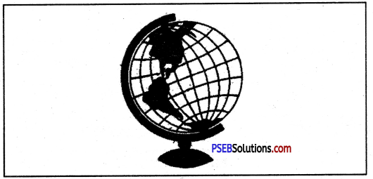
Globe shows the earth in its true shape. The shapes and sizes of all the physical features of the earth such as continents and oceans, distances and directions, etc. are correctly represented on it. As such, it is a correct replica of the round shape of the earth. That is why Globe is called a model of the earth.
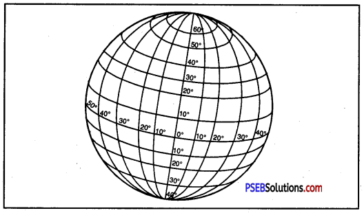
PSEB 6th Class Social Science Solutions Chapter 2 Globe - The Model of the Earth 1
Globe

Question 2.
What is the name of the ending of screw of Globe?
Answer:
The upper screw of Globe is known as North Pole and lower one is called South Pole.

Question 3.
What is the name given to the semi-circles that connect both the poles?
Answer:
The semi-circles that connect both the poles are named as longitudes.

Question 4.
What is Hemisphere? Name the line that cuts the Globe or Earth into the Hemispheres.
Answer:
The half of a sphere is called hemisphere. The equator cuts the Globe or Earth into the hemispheres.

PSEB 6th Class Social Science Solutions Chapter 2 Globe - The Model of the Earth

Question 5.
What is the Prime Meridian? From where it passes?
Answer:
0° longitude is called the Prime Meridian. It passes through Greenwich in England.

Question 6.
What is the difference between Longitudes and Latitudes?
Answer:
Longitudes are angular distances of a place from the Prime Meridian, whereas latitudes are angular distances of a place from the equator.

Question 7.
Why longitudes are called Meridians of Longitude? Into how many Meridians do we divide the Earth or Globe?
Answer:
Longitudes are called Meridians of Longitude because they are drawn through the Prime Meridian. We divide the Earth or Globe into 360° meridians.

Question 8.
Which is the largest circle of Globe? Name it.
Answer:
The circle of equator is the largest circle of Globe.

Question 9.
What is the difference between Parallels of Latitude and Meridians of Longitude?
Answer:

Parallels of Latitude Meridians of Longitude
1. Parallels of latitude are imaginary circles drawn parallel to the equator. 1. Meridians of longitude are imaginary lines running from North to South.
2. These are circles. 2. These are semi circles.
3. The distance between them is measured in degrees of latitude. 3. The distance between them is measured in degrees of longitude.
4. They are 180+1 in number. 4. They are 360 in number.

Question 10.
What is the importance of Longitudes?
Answer:
The importance of longitudes is as follow :

  1. Longitudes help us in knowing the east-west distance of a place.
  2. They help us in calculating the local time of a place.

Question 11.
Which lines help us to divide the Earth into Heat Zones? Give reasons why there are Heat Zones.
Answer:
Latitudes help us to divide the earth into Heat Zones. Heat Zones are there because of the following reasons :
1. The rays of the sun which are vertical, occupy less space but intensity of heating is very high and the rays of the sun which are slanting, occupy more space but intensity of heating is low.

2. The shape of the earth is spherical. The central, the bulging part of the earth receives maximum heat of the sun and as we go away from the central part towards the poles, the heat reduces.

Question 12.
What is the difference between Local Time and Indian Standard Time?
Answer:
1. Local Time. Local time is the time reckoned by the noon sun at a given place. At any place a watch can he adjusted to read 12 O’ clock when the sun is at the highest point in the sky or when it is mid day. The time shown by such a watch will give the local time for that place. All the places, on a given meridian of longitude, have the same local time.

2. Indian Standard Time. In a particular country, local time of a particular or rather a central place is adopted as the uniform time for the whole country. It is called the standard time of that country or that area. In India, the local time of 8214 ° E Longitude is used as the standard time for the whole country. It is called the Indian Standard Time. 8214° E is thus the standard meridian of India.

II. Fill in the blanks :

Question 1.
Tropic of Cancer is depicted by ________ Parallel of Latitude.
Answer:
0 to 23 1/2° North

Question 2.
Tropic of Capricorn is depicted by ________ Parallel of Latitude.
Answer:
0 to 23 1/2° South

PSEB 6th Class Social Science Solutions Chapter 2 Globe - The Model of the Earth

Question 3.
Latitudes and Longitudes make a on a Globe.
Answer:
grid

Question 4.
The distance between any two parallels is always ________
Answer:
equal

Question 5.
The ________ is also known as Zero Meridian.
Answer:
Prime Meridian

Question 6.
In India, the Longitude of ________ is considered the Standard Meridian.
Answer:
82 1/2° East

Question 7.
The time difference between Greenwich Mean Time and Indian Standard Time is ________
Answer:
5 hours 30 minutes.

III. Say whether the following statements are True or False :

Question 1.
Each parallel of Latitude is a semi-circle.
Answer:
False

Question 2.
Temperature increases as we go away from the equator.
Answer:
False

PSEB 6th Class Social Science Solutions Chapter 2 Globe - The Model of the Earth

Question 3.
The Torrid Zone lies between the Tropic of Cancer and Tropic of Capricorn.
Answer:
True.

Question 4.
The Earth rotates from the West to East direction.
Answer:
True.

IV. Things To Do (Activity):

Question 1.
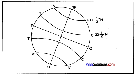
Draw a diagram of the earth, liark the earth’s Axis, the Great Circle, Tropic of Cancer, Tropic of Capricorn, Arctic Circle and Antarctic Circle on it.
Answer:

  • N.P. – S.P. = Axis
  • EQ = Great Circle
  • TC = Tropic of Cancer
  • T’C’ = Tropic of Capricorn
  • AR = Arctic Circle
  • A’N’ = Antarctic Circle.

PSEB 6th Class Social Science Solutions Chapter 2 Globe - The Model of the Earth 2

PSEB 6th Class Social Science Guide Globe – The Model of the Earth Important Questions and Answers

Multiple Choice Questions :

Question 1.
As earth is a globe, most accurate model of it is :
(A) Map on chart
(B) Globe
(C) Map on spherical fruit
(D) Map on a circular paper.
Answer:
(B) Globe.

Question 2.
A system of orbiting satellites that send radio signals to receivers on earth is a
(A) Navigator
(B) Radio
(C) Radar
(D) GPS.
Answer:
(D) GPS.

PSEB 6th Class Social Science Solutions Chapter 2 Globe - The Model of the Earth

Question 3.
A great circle is a circle which passes through the centre of the earth and bisects it into two equal hemispheres is called :
(A) Arctic circle
(B) Antarctic circle
(C) Great circle
(D) Equator.
Answer:
(C) Great circle.

Question 4.
The ends of the axis are called :
(A) Equator
(B) Poles
(C) Great Divide
(D) Great Circle.
Answer:
(B) Poles.

Question 5.
The zone with moderate temperatures is called :
(A) Temperate zone
(B) Tropical zone
(C) Equatorial zone
(D) None of these.
Answer:
(A) Temperate zone.

Fill in the Blanks :

Question 1.
The tropic of capricorn is located at ________
Answer:
23% south of equator

Question 2.
The standard meridian of India is ________
Answer:
82’4° East,

Question 3.
The 0° meridian is also known as ________
Answer:
Prime meridian

PSEB 6th Class Social Science Solutions Chapter 2 Globe - The Model of the Earth

Question 4.
The distance between the longitudes decreases towards ________
Answer:
Poles

Question 5.
The arctic circle is located in the hemisphere.
Answer:
Northern.

True/False :

Question 1.
Frigid zone lies between the arctic circle and the north pole.
Answer:
True

Question 2.
With longitudes we can divide the earth into heat zones.
Answer:
False

Question 3.
Local time is the time of a central meridian of an area.
Answer:
False

Question 4.
Latitude is the angular distance of a place north to south of the equator.
Answer:
True

PSEB 6th Class Social Science Solutions Chapter 2 Globe - The Model of the Earth

Question 5.
I.S.T. is termed as Indian Standard Time.
Answer:
False

Very Short Answer Type Questions

Question 1.
Name the two Hemispheres.
Answer:
The two Hemispheres are Northern Hemisphere and Southern Hemisphere.

Question 2.
What is Northern Hemisphere?
Answer:
The northern and upper part of Globe from equator is called Northern Hemisphere.

Question 3.
What is Southern Hemisphere?
Answer:
The southern and lower part of Globe from equator is known as Southern Hemisphere.

Question 4.
Explain Parallel Lines.
Answer:
Parallel lines’are those lines which run at equal distance and never meet with each other. They may be straight or circular.

Question 5.
What is Equatorial Line?
Answer:
The line drawn through the centre or 0° latitude is known as Equatorial Line.

Question 6.
How many Parallels of Latitude are there?
Answer:
There are 180+1 Parallels of Latitude.

Question 7.
What degree of angle does the equator represent?
Answer:
The equator represents 0° latitude.

PSEB 6th Class Social Science Solutions Chapter 2 Globe - The Model of the Earth

Question 8.
What does 90° South Latitude indicate?
Answer:
90° South Latitude indicates South Pole.

Question 9.
Where does the Tropic of Cancer lie on Globe?
Answer:
The Tropic of Cancer lies in the Northern Hemisphere on Globe.

Question 10.
What is the angular distance of the Tropic of Cancer from the equator?
Answer:
The angular distance of the Tropic of Cancer from the equator is 231/4° North.

Question 11.
What is the angular distance of the Tropic of Capricorn from the equator?
Answer:
The angular distance of the Tropic of Capricorn from the equator is 2354° South.

Question 12.
What is the Indian Standard Time?
Answer:
The Indian Standard Time is taken in the longitude of 8214° E.

Question 13.
Which area on the earth receives the maximum heat?
Answer:
The area lying between the Tropic of Cancer and the Tropic of Capricorn receives the maximum heat.

Question 14.
Into how many Heat Zones has the earth been divided?
Answer:
The earth has been divided into three Heat Zones.

PSEB 6th Class Social Science Solutions Chapter 2 Globe - The Model of the Earth

Question 15.
What is the basis of the division of Heat Zones?
Answer:
Temperature is the basis of the division of Heat Zones.

Short Answer Type Questions

Question 1.
Distinguish between Northern Hemisphere and Southern Hemisphere.
Answer:

Northern Hemisphere Southern Hemisphere
1. The part of the earth which lies in the northern part of equator is called Northern Hemisphere. 1. The part of the earth which lies to the south of the equator is called Southern Hemisphere.
2. 0° to 90° North latitude mark Northern Hemisphere. 2. 0° to 90° South latitude mark Southern Hemisphere.

Question 2.
Distinguish between Latitude and Longitude.
Answer:

Latitude Longitude
1. Latitude is the angular distance of a place North or South of the Equator. 1. Longitude is the angular distance of a place East or West of Prime Meridian.
2. The latitude value increases in North-South directions from the Equator. 2. The longitude value increases in East-West directions from meridian.
3. Its value ranges between 0° to 90° N, 0° to 90°S. 3. Its value ranges between 0° to 180°E, 00 to 180°W.

PSEB 6th Class Social Science Solutions Chapter 2 Globe - The Model of the Earth

Question 3.
Distinguish between Local and Standard Time.
Answer:

Local Time Standard Time
1. Local time of a place is the time of its meridian. 1. Standard time is the time of a central meridian of an area.
2. Each place has its own local time. 2. All places have a uniform or same time.
3. When it is noon, the local time is 12 o’clock. 3. It has not any relation with noon or height. of the sun.
4. All places on the Meridian have same local time. 4. All places within a country have the same standard time.
5. The places in the East are ahead of west in time. For 10 longitude there is difference of 4 minutes of time. 5. There is no change in time. So it is known as standard time.

Question 4.
In which hemisphere does the Tropic of Cancer lie?
Answer:
The Tropic of Cancer lies in the Northern Hemisphere. It is at an angular distance of 23’A° North from the equator. It runs in an east-west direction almost mid-way through our country.

Question 5.
What are Temperate Zones?
Answer:
The areas bounded by the Tropic of Cancer and the Arctic Circle in the Northern Hemisphere and the Tropic of Capricorn and the Antarctic Circle in the Southern Hemisphere are called Temperate Zones.

Question 6.
What are Frigid Zones?
Answer:
The areas lying between the Arctic Circle and the North Pole in the Northern Hemisphere and the Antarctic Circle and the South Pole in the Southern Hemisphere are known as Frigid Zones.

PSEB 6th Class Social Science Solutions Chapter 2 Globe - The Model of the Earth

Question 7.
Where is Greenwich? For what is it famous?
Answer:
Greenwich lies near London in England. It is the place where British Royal Observatory is located. Greenwich Mean Time (GMT) has been fixed here.

Question 8.
Discuss the importance of Grid.
Answer:
The importance of Grid is as follows :
1. Grid helps us in making maps and atlases.
2. It helps us in reading maps.
3. It helps us in fixing the boundary between two countries.
PSEB 6th Class Social Science Solutions Chapter 2 Globe - The Model of the Earth 3
Grid

Question 9.
What is the importance of Latitudes?
Answer:
The importance of latitudes can be discussed as under :
1. We can very easily form an idea of the temperature of a place.
2. We can divide the earth into Heat Zones.
3. We can find the exact location of a place.

Question 10.
Why do we use models to show earth?
Answer:
The earth is very large in size. We cannot’ see the whole of the earth in its actual size and shape in one go. So we use models, photographs, and maps to see the earth.

Question 11.
Why is the globe a correct replica of the earth?
Answer:
On the globe, shapes, sizes, distance and directions of continents and oceans are correctly represented.

Question 12.
How many parallels of latitude are there?
Answer:
There are 90 imaginary lines drawn to the north of equator and 90 imaginary lines drawn to the south of equator. It makes 181 parallels of latitude in all.

PSEB 6th Class Social Science Solutions Chapter 2 Globe - The Model of the Earth

Question 13.
How to locate a place on it (The Earth/Globe)?
Answer:
If we want to locate a place on the globe we have to do the following exercise :

  • First we have to know the latitude and longitude of that place.
  • Now we draw the meridian and parallel of latitude of that place on the basis of its longitude and latitude.
  • The point where these meridian and parallel of latitude intersect themselves, will be the location of that place.

Question 14.
Do you know what is the time difference between India and England?
Answer:
The time difference between India and England is of 5.30 hours.
1. If it is noon in England, it is 5.30 p.m. in India because time is ahead in India than in England by 5.30 hours.

2. This can be calculated in the following manner :

  • Difference between 0° longitude and 82 1/4° E longitude = 82 1/4°
  • Time in the East is ahead by 4 minutes on passing every meridian
  • Hence time ahead 82 1/4° × 4 = 330 minutes or 5.30 hours.

Long Answer Type Questions

Question 1.
In what way is a globe different from maps?
Answer:
Globe is a true jnodel of the earth while a map is a picture of the earth. A globe has three dimensions, while a map has two dimensions. Globe gives correct idea of shape of the earth, but a map gives details of an area. It is easy to carry maps, but globes are not portable. Globe is not*fixed. It can be rotated while map is fixed. A globe can be rotated as a top spin or a potter’s wheel. On the globe, countries, continents and oceans are shown in their correct size.

PSEB 6th Class Social Science Solutions Chapter 2 Globe - The Model of the Earth

Question 2.
List the situation in which the globe is far more useful than maps.
Answer:

  • Earth is truly shown by a globe. It gives shapes and directions correctly.
  • It is a true model of our planet.
  • Lines of latitudes and longitudes are shown correctly on a globe.
  • NoW-a- days relief features can be shown on globe.
  • It can be rotated on its axis.
  • Globe is an important tool of Geography.
  • Globe can be rotated like a top spin or a potter’s wheel.

Question 3.
What are the shortcomings of a globe?
Answer:
A globe has some limitations :

  • It is not easy to carry globes.
  • It is not useful for studying an area of a country.
  • Only one hemisphere can be studied from a globe.
  • Distances cannot be measured on a spherical globe.
  • Globes do not show details.

Question 4.
Into how many Heat Zones can tile earth be divided? Explain each zone.
Answer:
The earth can be divided into three Heat Zones. They are Torrid Zone, Temperate Zone and Frigid Zone.
1. Torrid Zone: It lies between the Tropic of Cancer and the Tropic of Capricorn. It is the hottest zone of the world. The noon sun shines vertically over this part of the earth.

2. Temperate Zone: It lies between the Tropic of Cancer and the Arctic Circle in the Northern Fig. Heat Zones of Earth
Hemisphere and between the Tropic of Capricorn and the Antarctic Circle in the Southern Hemisphere. The sun is never overhead in this zone. It is neither very hot in summer nor very cold in winter. It is, therefore, called the Temperate Zone.

3. Frigid Zone: It lies between the Arctic Circle and the North Pole in the Northern Hemisphere and the Antarctic Circle and the South Pole in the Southern Hemisphere.

Question 5.
Describe the important Parallels of Latitude.
Answer:
The Equator, the Tropic of Cancer, the Tropic of Capricorn, the Arctic Circle, and the Antarctic Circle is the important Parallels of Latitude.

  1. The Equator: The equator is the most important parallel of latitude. It divides the earth into two equal parts. These parts are the Northern Hemisphere and the Southern Hemisphere. It is the largest possible circle that can be drawn around the earth.
  2. The Tropic of Cancer: It lies in the Northern Hemisphere at 23°30′ latitude. It is an angular distance of 2314° N from the equator.
  3. The Tropic of Capricorn: It is also an imaginary circle measuring the angular distance of 23/4° to the south from the central point of the equator.
  4. The Arctic Circle: It is the parallel of latitude that lies at a distance of 6614° North of the equator.
  5. The Antarctic Circle: It lies in the Southern Hemisphere and is at 66!4° South to the equator.

PSEB 6th Class Social Science Solutions Chapter 2 Globe - The Model of the Earth

Question 6.
How do longitudes help us in calculating time?
Answer:
Longitude and Time.

  • Longitudes help us to calculate time.
  • It takes 24 hours for the earth to complete one rotation.
  • This means in 24 hours the Earth completes 360°.
  • Hence, it takes about 4 minutes for crossing one degree of longitude.
  • This means each place has a different time of Sunrise and Sunset.
  • Places East of the Greenwich Meridian experience day or sunrise earlier than the places lying west of this Meridian.

In other words, time is ahead in the east than that in the west, at the rate of 4 minutes per degree of longitude.

PSEB 6th Class Social Science Solutions Chapter 1 Earth – As a Member of Solar System

Punjab State Board PSEB 6th Class Social Science Book Solutions Geography Chapter 1 Earth – As a Member of Solar System Textbook Exercise Questions and Answers.

PSEB Solutions for Class 6 Social Science Geography Chapter 1 Earth – As a Member of Solar System

SST Guide for Class 6 PSEB Earth – As a Member of Solar System Textbook Questions and Answers

I. Answer the following questions in brief :

Question 1.
What do you mean by the Universe? Enlist the different forms of the Universe.
Answer:
The Universe is a vast and infinite space having millions of galaxies.

Composition of Universe
PSEB 6th Class Social Science Solutions Chapter 1 Earth - As a Member of Solar System 1

It consists of the sun, the planets, the earth, the moon, stars, dust particles, gases, etc. It is so large that one can’t estimate its size.

Forms of the Universe.The galaxy, milky way, planets, satellites, asteroids, comets, meteors and meteorites are the different forms of the Universe.

Question 2.
What is a planet? Is our earth a planet? How?
Answer:
A planet is a celestial (heavenly) body which draws heat and light from the sun and also revolves around it.The word ‘planet’ comes from the Greek word ‘planetai’ which means wanderer (moving thing). Planets are opaque bodies and reflect the Sun’s light.

Yes, our earth is a planet. It gets heat and light from the sun and moves around it in a particular direction in the space. There are eight planets.

PSEB 6th Class Social Science Solutions Chapter 1 Earth - As a Member of Solar System

Question 3.
What do you understand by Solar System?
Answer:
The sun and, the eight planets which revolve around it make up the Solar System. In addition to the eight planets, there are 63 satellites in the Solar System. The Solar System is also known as the Family of the Sun. The sun is the centre of solar system. Sol in Roman mythology means Sun God.
PSEB 6th Class Social Science Solutions Chapter 1 Earth - As a Member of Solar System 2
The eight planets in the order of their distance from the Sun.

Question 4.
Enlist the distance of planets from the sun. Also tell which planet is far away and which is nearest.
Answer:
There are eight planets. As per their distance from the sun, they are :

  1. Mercury,
  2. Venus,
  3. Earth,
  4. Mars,
  5. Jupiter,
  6. Saturn,
  7. Uranus,
  8. Neptune.

Of these planets, Neptune is the farthest and Mercury is the nearest.

Question 5.
Enlist planets according to the size of planets.
Answer:
In ascending order, the sizes of planets are as follows :

  1. Mercury,
  2. Mars,
  3. Venus,
  4. Earth,
  5. Neptune,
  6. Uranus,
  7. Saturn,
  8. Jupiter.

Question 6.
Which facts do you know that tell us the shape and size of the earth?
Answer:

  1. Shape of the Earth: The earth is not flat, it is round in shape. It is like a very big ball.
  2. Size of the Earth: As far as size of the earth is concerned, it ranks fifth among the planets. It is smaller than Jupiter and Saturn. Its diameter is 12,756 km. Its circumference is 40,000 km. On poles its diameter is 12,712 km. It means that its diameter on the poles is lesser by 44 km than the equator.

PSEB 6th Class Social Science Solutions Chapter 1 Earth - As a Member of Solar System

Question 7.
Write notes on the following :
(а) Planet
Answer:
Planet: A planet is a gaseous ball that moves around the sun. It moves in a particular direction in the space. It has no heat or light of its own. It receives heat and light from the sun. There are eight known planets.

(b) Meteors
Answer:
Meteors: Meteors are also known as Shooting Stars. They are small bodies which come from inter-planetary space. When they enter the earth’s surface, they get fire by friction. As a result, a lot of light appears trailing,. These are called meteors.

(c) Sphere
Answer:
Sphere: The earth has two ends. Northern end is known as Northern Pole and southern end is called Southern Pole.

(d) Equator
Answer:
Equator: Equator is an imaginary line that runs east to west in the centre of the earth. It divides the earth into two equal halves.

(e) Tailed Star
Answer:
Tailed Star: A comet is called a tailed star. It is trailed by a long tail of light.

(f) Axle/Axis
Answer:
Axle/Axis: Axle/Axis is an imaginary line that passes through and joins Northern Pole and Southern Pole of the earth.

(g) Asteroids
Answer:
Asteroids: Asteroids are small planets which revolve around the sun. They lie between the orbits of Mars and Jupiter.

(h) Lunar Eclipse.
Answer:
Lunar Eclipse: The earth revolves around the sun and the moon moves around the earth. During their revolution, when the earth comes between the sun and the moon, it casts its shadow on the moon. It is called Lunar Eclipse.

II. Fill in the blanks in the following :

Question 1.
Our earth is a flat sphere, therefore it is called ____________
Answer:
an oblate spheroid

Question 2.
The circumference of the earth is ____________ km.
Answer:
40,000

Question 3.
The diameter of earth on equator is ____________ km and diameter of earth at poles is km.
Answer:
12,756, 12,712.

III. Activity (Something To Do)

Question 1.
Show the planets according to the distance from the Sun.
Answer:
PSEB 6th Class Social Science Solutions Chapter 1 Earth - As a Member of Solar System 3

S.No. Planet Distance from the Sun (million kms)
1. Mercury 58 (The nearest)
2. Venus 108
3. Earth 150
4. Mars 226
5. Jupiter 778
6. Saturn 1427
7. Uranus 2870
8. Neptune 4496 (The farthest)

PSEB 6th Class Social Science Solutions Chapter 1 Earth - As a Member of Solar System

Question 2.
Enlist the planets according to their size.
Answer:

S. No. Planet Size
1. Jupiter 1st (The largest)
2. Saturn 2nd
3. Uranus 3rd
4. Neptune 4th
5. Earth 5th
6. Venus 6th
7. Mars 7th
8. Mercury 8th (The smallest)

PSEB 6th Class Social Science Guide Earth – As a Member of Solar System Important Questions and Answers

Multiple Choice Questions :

Question 1.
Which is the nearest planet to the sun?
(A) Neptune
(B) Mars
(C) Mercury
(D) Earth.
Answer:
(C) Mercury.

Question 2.
The tilting of earth is responsible for :
(A) Change of the days
(B) Change of the sunrays
(C) Change of the seasons
(D) None of these.
Answer:
(C) Change of the seasons.

Question 3.
Stars appear to move from :
(A) West to East
(B) East to West.
(C) North to South
(D) South to West
Answer:
(B) East to West.

PSEB 6th Class Social Science Solutions Chapter 1 Earth - As a Member of Solar System

Question 4.
What are the tiny bodies between the orbit of Mars and Jupiter called?
(A) Asteroids
(B) Comets
(C) Meteor
(D) Meleorities
Answer:
(A) Asteroids.

Question 5.
Which is the largest planet in solar system?
(A) Mercury
(B) Mars
(C) Jupiter
(D) Saturn.
Answer:
(C) Jupiter.

Fill in the Blanks :

Question 1.
____________ planet appears to be yellowish.
Answer:
Saturn

Question 2.
____________ study the space and travel.
Answer:
Astronauts

Question 3.
Group of shining stars is called ____________
Answer:
Constellation

Question 4.
____________ is a group of seven stars.
Answer:
Saptarishi

Question 5.
____________ is called a tailed star.
Answer:
A comet.

True/False :

Question 1.
There are 7 planets in our solar system.
Answer:
False

Question 2.
The universe includes the sun, satellites, planets, stars etc.
Answer:
True.

Question 3.
Geoid means sunlike shape.
Answer:
False

Question 4.
Moon is a natural satellite of the earth.
Answer:
True.

PSEB 6th Class Social Science Solutions Chapter 1 Earth - As a Member of Solar System

Question 5.
The earth has a circumference of 40000 km.
Answer:
True.

Very Short Answer Type Questions

Question 1.
What do you mean by Geoid?
Answer:
Geoid means earth like shape.

Question 2.
Who are astronauts?
Answer:
Astronauts are the persons who study the space and travel in the space. Kalpna Chawla was an astronaut of Indian origin.

Question 3.
Why does the sun appear big to us?
Answer:
The sun appears big to us because it is nearest to the earth.

Question 4.
What do you understand by constellation?
Answer:
A group of shining stars is called constellation.

Question 5.
What is Saptarishi?
Answer:
Saptarishi is a group of seven stars, which appears like a Great Bear.

Question 6.
Which planets rotate in a different direction than our earth?
Answer:
Venus and Uranus rotate in a different direction than our earth.

Question 7.
What is the name of the star nearest to earth?
Answer:
The sun is the star nearest to earth.

PSEB 6th Class Social Science Solutions Chapter 1 Earth - As a Member of Solar System

Question 8.
How much time does the light of the sun take to reach the earth?
Answer:
It takes eight minutes to reach the earth.

Question 9.
What is the distance between the sun and the earth?
Answer:
The distance between the sun and the earth is 15 crore kms.

Question 10.
What is Akash Ganga or Milky Way?
Answer:
Akash Ganga or Milky Way is a part of galaxy consisting of a million of stars and planets.
PSEB 6th Class Social Science Solutions Chapter 1 Earth - As a Member of Solar System 4

Question 11.
Name the largest and the smallest planets.
Answer:
Jupiter is the largest and Neptune is the smallest planet.

Question 12.
Name the planets which have no satellites.
Answer:
Mercury and Venus.

Question 13.
How much time does the moon take to complete one cycle around the earth and its own axis?
Answer:
27 days and 7 hours.

PSEB 6th Class Social Science Solutions Chapter 1 Earth - As a Member of Solar System

Question 14.
After whose name has the Comet Halley been named?
Answer:
Comet Halley has been named after the astronomer of England ‘Almond Halley’.

Question 15.
What are spheroids?
Answer:
The spheres of the earth which are flat on the top and bottom are called spheroids.

Question 16.
Name the four planets which are bigger than the earth.
Answer:
Jupiter, Saturn, Uranus and Neptune.

Short Answer Type Questions

Question 1.
Why is the earth called a blue planet?
Answer:
Astronauts, who have seen the earth from space, say that the earth appears blue in colour. It is due to the presence of water. Therefore, the earth is called a blue planet.

Question 2.
What is the distance of the earth from sun and from the moon?
Answer:

  1. Earth from sun-1,50 million kms.
  2. Earth from moon-3,84,400 kms.

Thus the distance of earth from the sun is about 40 times more than that from the moon.

PSEB 6th Class Social Science Solutions Chapter 1 Earth - As a Member of Solar System

Question 3.
Why do we see only one side of the moon?
Answer:
The moon revolves around the earth in 27 days and 7 hours.
It takes exactly the same time in completing one rotation about its axis. As such, we see only one side of the moon while the other side always remains away from us.

Question 4.
Describe the composition of the Solar System.
Answer:
The Solar System is composed of the sun and the eight planets which revolve around it. The sun is the creator of the planets.

The planets are named after Greek gods and goddesses. In addition, there are in all 63 satellites or moons in the Solar System.

Question 5.
What is meant by a satellite? How many satellites are there in the Solar System?
Answer:
The word ‘satellite’ means a smaller companion to anything.
There are 63 satellites in the Solar System. The satellites revolve j around their planets and also follow them in their revolution around the sun. For example, the moon is the satellite of the earth which moves around the earth and also around the sun along with the earth.

Question 6.
Tell the main physical conditions prevalent on the moon.
Answer:
The moon has rugged and barren surface. There is no air or water on the moon. It is very hot during the day and very cold during the night.

Question 7.
What are Novae?
Answer:
Novae are stars which seem to appear out of nowhere and later disappear. They are also known as new stars. Today, we know a truly new star does not appear and only a dim star suddenly brightens up.

PSEB 6th Class Social Science Solutions Chapter 1 Earth - As a Member of Solar System

Question 8.
Why do the stars twinkle?
Answer:
The light from the stars travels through different layers of space. Therefore, the light rays deviate from its original path. Further, these rays are not stationary but keep on moving. This leads to the twinkling effect of the stars.

Question 9.
State some characteristics of celestial bodies.
Answer:

  1. They are very big and hot.
  2. These are made up of gases.
  3. These have their own heat and light.
  4. These are numerous.
  5. These are very away from us and look tiny.

Question 10.
What is a Tailed Star?
Answer:
Comets are called Tailed Stars. These are clusters of gases and dust. The comet is trailed by a long tail of light. That is why it is called a Tailed Star.

Question 11.
What is Halley’s comet?
Answer:
Halle/s comet is a narrow loop-like comet. This star appears after a gap of 76 years, It last appeared in the sky in 1956.

PSEB 6th Class Social Science Solutions Chapter 1 Earth - As a Member of Solar System

Question 12.
What are shooting stars?
Answer:
Meteors and Meteorites are called shooting stars. When these enter the atmosphere, the matter gets fire. So these are called shooting stars. Half burnt meteors are called Meteorites. Arizona (USA) crator is formed due to falling of a meteorite.

Long Answer Type Questions

Question 1.
What is the place of the earth in the Solar System?
Answer:
The earth is the third nearest planet to the sun. It lies between Venus and Mars and is the fifth largest planet. It has an equatorial diameter of 12,756 km and a polar diameter of 12,712 km. Its circumference is 40, 000 km. It is the only planet in the Solar System where life is possible. Water and air support all forms of life on the earth.

Question 2.
What do you know about the moon?
Answer:
The moon is the only satellite of the earth. It is over one quarter size of the earth. Its diameter is 3,476 km. It is also the nearest neighbour of the earth. It is at a mean distance of 3,84,000 km centre to centre and 3,76,284 km surface to surface. Its average orbital speed is 3,680 km per hour.

The moon revolves round the earth. Its position in relation to the sun changes every day, as it reflects the light of the sun.
PSEB 6th Class Social Science Solutions Chapter 1 Earth - As a Member of Solar System 5
Various phases of the moon

Question 3.
Distinguish between a star and a planet.
Answer:

Star Planet
1. Stars are heavenly bodies shining by their own heat and light. 1. Planets are opaque heavenly bodies which reflect the light of the sun.
2. Millions of stars, scattered in space, occur in clusters. 2. Nine planets revolve around the sun.
3. Stars emit a large amount of heat and light. 3. Planets reflect the light of the sun.
4. Stars twinkle due to radiation of their heat and light. 4. Planets do not twinkle.

PSEB 6th Class Social Science Solutions Chapter 1 Earth - As a Member of Solar System

Question 4.
Distinguish between a planet and a satellite.
Answer:

Planet Satellite
1. Planet receives heat and light from the sun. 1. They have no light of their own.
2. These are spherical in shape. 2. These are small bodies.
3. There are 8 planets in our solar system. 3. There are 110 Satellites.
4. A planet means a wanderer. 4. A satellite means a companion.

Question 5.
Why is the earth called a unique planet?
Answer:
The earth is a unique planet because it is the only planet having life for animals and plants. It is a unique planet due to the ahead reasons :

  1. The presence of Oxygen and Nitrogen in the atmosphere around the earth favours the existence of life on the earth.
  2. Water cycle on the earth provides water for all living beings. No other planet of the solar system has water.
  3. The earth is neither too hot nor too cold. Moderate temperatures favour life on the earth. It has suitable temperatures for life.
  4. Ozone layer protects us from harmful solar rays (ultra-violet rays).

Question 6.
Why do we see only one side of the Moon always?
Answer:
The Moon is a satellite of the Earth.

  • It moves around the Sun along with the Earth.
  • It takes 27 days to revolve around the earth.
  • It takes exactly the same time to complete one rotation about its axis.
  • That is why we can see only one side of the Moon. The other side always remains away from us.
  • The places on the moon correspond to places on earth always.

PSEB 6th Class Social Science Solutions Chapter 6 Our India – In World

Punjab State Board PSEB 6th Class Social Science Book Solutions Geography Chapter 6 Our India – In World Textbook Exercise Questions and Answers.

PSEB Solutions for Class 6 Social Science Geography Chapter 6 Our India – In World

SST Guide for Class 6 PSEB Our India – In World Textbook Questions and Answers

I. Answer the following questions :

Question 1.
Which latitude divides India into two parts? Name the two parts.
Answer:
The Tropic of Cancer (23°30′ N) divides India into two parts. The northern part is called Sub-tropical India and the Southern part is known as Tropical India.

Question 2.
Name the neighbouring countries of India.
Answer:
India has seven countries as her neighbours. They are Pakistan, Afghanistan, China, Nepal, Bhutan, Myanmar and Bangladesh.

Question 3.
Write down the. latitudinal and longitudinal location of India.
Answer:
The latitudinal location of India is 8°4′ N to 37°6′ N and the longitudinal location is 67°7′ E to 97°25′ E.

Question 4.
Why is India called a sub-continent?
Answer:
India is called a sub-continent because she has a great longitudinal and latitudinal length. She stands out’distinctly from the rest of the countries of the world.

PSEB 6th Class Social Science Solutions Chapter 6 Our India - In World

Question 5.
Into how many States and Union Territories India is divided from administrative point of view?
Answer:
From administrative point of view, India is divided info 28 States and 8 Union Territories.

Question 6.
Write down the names of the three seas or oceans that engulf the Indian Peninsula.
Answer:
The Indian Peninsula is engulfed by the Indian Ocean, the Arabian Sea and the Bay of Bengal.

II. Fill in the blanks in the following :

Question 1.
_______ state is the lrgest state of India.
Answer:
Rajasthan

Question 2.
_______ is the smallest state of India.
Answer:
Goa

Question 3.
Indira Point is the _______ point of India.
Answer:
southernmost

Question 4.
From Kashmir to _______ India is one.
Answer:
Kanyakumari

PSEB 6th Class Social Science Solutions Chapter 6 Our India - In World

Question 5.
Arunachal Pradesh is in _______ part of India.
Answer:
eastern.

III. Make proper pairs:

Question 1.

A B
(i) Andaman and Nicobar (i) Our eastern neighbour
(ii) Maldives (ii) Southern neighbour
(iii) Myanmar (iii) Indian Island Group
(iv) Sri Lanka (iv) Connected through oceanic boundary

Answer:

A B
(i) Andaman and Nicobar (iii) Indian Island Group
(ii) Maldives (ii) Southern neighbour
(iii) Myanmar (i) Our eastern neighbour
(iv) Sri Lanka (iv) Connected through oceanic boundary

Activity (Something To Do)

Question 1.
Name two main port cities which are also capital cities.
Answer:
Mumbai and Chennai.

PSEB 6th Class Social Science Solutions Chapter 6 Our India - In World

Question 2.
Name three capital cities that are located fairly close to the tropic of cancer.
Answer:

  1. Gandhinagar
  2. Bhopal
  3. Ranchi.

Question 3.
Name five states from West to East.
Answer:

  1. Gujarat
  2. Madhya Pradesh
  3. Jharkhand
  4. West Bengal
  5. Tripura.

PSEB 6th Class Social Science Solutions Chapter 6 Our India - In World 1

Area, Population And Density Of States And Union Territories (2011):
PSEB 6th Class Social Science Solutions Chapter 6 Our India - In World 2
PSEB 6th Class Social Science Solutions Chapter 6 Our India - In World 3
PSEB 6th Class Social Science Solutions Chapter 6 Our India - In World 4
PSEB 6th Class Social Science Solutions Chapter 6 Our India - In World 5

Based upon the Survey of India map, with the permission of the Surveyor General of India. The territorial waters of India extend into the sea to a distance of twelve nautical miles measured from the appropriate baseline. The boundary of Meghalaya shown on this map is as interpreted from the North-Eastern Areas (Reorganisation) Act. 1971, but has yet to be verified. Responsibility for the correctness of internal details shown on the map rests with the publisher.

PSEB 6th Class Social Science Guide Our India – In World Important Questions and Answers

Multiple Choice Questions :

Question 1.
Which of the following is the exact north-south extent of India?
(A) 2933 km
(B) 3214 km
(Q 2930 km
(D) 3014 km
Answer:
(B) 3214 km.

PSEB 6th Class Social Science Solutions Chapter 6 Our India - In World

Question 2.
Which of the following is the southernmost tip of the mainland?
(A) Kanyakumari
(B) Indira point
(Q J&K
(D) Malabar.
Answer:
(A) Kanyakumari.

Question 3.
How many islands lie in the Bay of Bengal?
(A) 250
(B) 204
(C) 205
(D) 206.
Answer:
(B) 204.

Question 4.
Which one of the following longitudes is the standard meridian for India?
(A) 69° 30’ E
(B) 82° 30’ E
(C) 75° 30’ E
(D) 90° 30’ E.
Answer:
(B) 82° 30’ E.

Question 5.
Which one of the following countries is larger in area than India?
(A) China
(B) Egypt
(C) France
(D) Iron.
Answer:
(A) China.

Fill in the Blanks :

Question 1.
_______ separates as India from Sri Lanka.
Answer:
Palk Strait

Question 2.
_______ is the smallest state of India.
Answer:
Goa

PSEB 6th Class Social Science Solutions Chapter 6 Our India - In World

Question 3.
Lakshadweep is the _______ U.T.
Answer:
Smallest

Question 4.
_______ is the southernmost point of India.
Answer:
Indira point

Question 5.
_______ separates the Andaman Islands from the Nicobar Islands.
Answer:
Ten-degree channel.

True/False :

Question 1.
India has four physiographic units.
Answer:
False

Question 2.
Ahmedabad is located on Tropic of Cancer.
Answer:
True.

PSEB 6th Class Social Science Solutions Chapter 6 Our India - In World

Question 3.
Fifteen states are coastal states of India.
Answer:
False

Question 4.
International boundaries of 7 countries touch India.
Answer:
True.

Question 5.
Lakshadweep is a group of coral islands.
Answer:
True.

Very Short Answer Type Questions

Question 1.
Name the Indian states having common frontiers with China.
Answer:
J&K, Uttarakhand, Himachal Pradesh, Sikkim, Arunachal Pradesh.

Question 2.
Between which latitudes and longitudes the Indian sub-continent lies?
Answer:
Between 8° N To 37° N latitude and 68°E to 97° E longitudes.

Question 3.
Name the major rivers of India which constitute the North Indian Plain.
Answer:
The major rivers of India constituting the North Indian Plain are the Sutlej, Ganga and Brahmaputra.

PSEB 6th Class Social Science Solutions Chapter 6 Our India - In World

Question 4.
Name five major hill ranges constituting the Purvanchal.
Answer:
Five major hill ranges constituting the Purvanchal are Patkoi Bum, Garo, Khasi, Jaintia and Lushai.

Question 5.
Why are the Himalayas called young mountains?
Answer:
The Himalayas are called young mountains because they have been formed recently in world history.

Question 6.
Which is the largest delta in the world?
Answer:
The Ganga-Brahmaputra Delta is the largest delta in the world.

Question 7.
Which strait separates India from Sri Lanka?
Answer:
Palk Strait separates India from Sri Lanka.

Question 8.
Name the largest and the smallest Union Territories in area.
Answer:
Andaman and Nicobar is the largest and Lakshadweep is the smallest in terms of area.

Question 9.
What is the length and breadth of the Himalayas?
Answer:
The length of the Himalayas is 3600 km and breadth is 150 to 400 km.

Question 10.
Name three ranges of the Himalayas.
Answer:
Three ranges of the Himalayas are the Shiwaliks, Himachal (Lesser Himalayas) and the Himadris (Greater Himalayas).

PSEB 6th Class Social Science Solutions Chapter 6 Our India - In World

Question 11.
What are dunes? Give one example.
Answer:
The longitudinal valleys between the Shiwaliks and Lesser Himalayas are called dunes. For example, Dehradun.

Question 12.
Name some famous hill stations found in Himachal ranges.
Answer:
Dalhousie, Shimla, Mussoorie, Nainital and Darjeeling are some famous hill stations found in Himachal ranges.

Question 13.
Name the highest mountain peak of the world.
Answer:
Mt. Everest is the highest mountain peak of the world. Its height is 8848 metres.

Question 14.
Name the highest mountain peak of the Himalayas in India.
Answer:
The highest mountain peak of the Himalayas in India is Kanchanjunga (Sikkim).

Question 15.
Name the plateaus in Central Highlands.
Answer:
Malwa, Bundelkhand, Baghelkhand and Chhotanagpur.

PSEB 6th Class Social Science Solutions Chapter 6 Our India - In World

Question 16.
Name the main ranges of Western Ghats.
Answer:
Sahyadri, Nilgiris, Annamalai and Cardamom hills.

Question 17.
Name a group of coral islands.
Answer:
The Lakshadweep Islands.

Short Answer Type Questions

Question 1.
Name the island groups in Arabian Sea and Bay of Bengal.
Answer:
The Arabian Sea has Lakshadweep Group of Islands and the Bay of Bengal has Andaman Group of Islands and Nicobar Group of Islands. India has almost a total of 250 islands, out of which 204 lie in the Bay of Bengal.

Question 2.
What is a sub-continent?
Answer:
A sub-continent is a part of continent, an independent geographical unit, distinctly separated from the main continent.

Question 3.
Write a short note on the Himalayas.
Answer:
The Himalayas are young fold mountains. They have been formed due to folding by different earth movements. Parallel mountain ranges are formed in these mountains. These mountains are the loftiest mountain system of the world. The highest mountain peak Mt. Everest (8848 mt.) lies in the Himalayas. These mountains extend in an arc. Here, deep gorges anc U-shaped valleys are formed.

PSEB 6th Class Social Science Solutions Chapter 6 Our India - In World

Question 4.
Distinguish Shiwaliks from Greater Himalayas.
Answer:

Shivalik Greater Himalayas
1. Shiwaliks are called Outer Himalayas. 1. Greater Himalayas are called Himadris.
2. These mountains have an average height of about 1200 metres. 2. These mountains have an average height of about 6000 metres.
3. These consist of loose unconsolidated sediments. 3. These consist of the highest peaks like Mt. Everest.

Question 5.
Describe the boundaries of India.
Answer:
Boundaries of India.

  • India is a country of vast geographical expanse.
  • It is bounded by the mighty Himalayas in the north.
  • Arabian sea bounds it in the west.
  • Bay of Bengal forms its boundary in the east.
  • Indian ocean bounds it in the south.

Question 6.
How is India a country of vast geographical expanse?
Answer:

  • India has an area of about 32.8 crore hectares.
  • Its north-south extent from Kashmir to Kanyakumari is about 3200 kms.
  • It extends east-west from Arunachal Pradesh to Kutchh over 2900 kms.
  • The lofty mountains, the Thar desert, the Northern plains, Peninsular Plateau, east and west coasts and islands present a diversity of land forms.

PSEB 6th Class Social Science Solutions Chapter 6 Our India - In World

Question 7.
How does unity in diversity exist in India?
Answer:
(a) There is a great variety in climate, vegetation, wildlife as well as language and culture in India.
(b) In this diversity there is unity. It is reflected in traditions that bind us as one nation.
(c) India has a population of 1.22 billion crore according to the Census of 2011.
(d) It is the second-most populous country of the world after China.

Question 8.
Write any four features of the Ganga Basin.
Answer:
The Ganga basin is a part of northern plains. It lies at the foot of the Himalayas. It is an alluvium plain formed by the deposition of sediments brought from the Himalayas by rivers. It is a flat lowland. It has fertile alluvial soils, namely Khadar and Bangar. These soils have led to the development of agriculture. The basin has been divided into many Doabs.

Question 9.
Name the major rivers of Peninsular India.
Answer:
Some rivers of Peninsular India flow eastward into the Bay of Bengal. These are Mahanadi, Godavari, Krishna and Kaveri. Some rivers flow westward into the Arabian Sea. These rivers include Narmada and Tapti.

Long Answer Type Questions

Question 1.
Describe the Northern Plains of India.
Answer:
The Northern Plains of India are a region of a vast alluvial plain. This region extends from Punjab-Haryana Plains to Assam Valley. It is 3200 km long and 150 to 300 km wide. Its average height is 150 metres. It covers an area of 7.5 lakh sqvkm.

It can be divided into the following parts :
1. The Punjab-Haryana Plains. These plains owe their origin to the depositional work of the Sutlej, the Beas and the Ravi rivers. This is a uniform and flat plain and is formed by the Indus and its five tributaries. Due to creation of international border between India and Pakistan in 1947, greater part of it went to Pakistan. To the other side, due to the rise of surface near Delhi, the Yamuna has started flowing towards east. Delhi and its surrounding area work as a water divide between the Ganga and Indus River Drainage System.

The interfluves formed on the basis of river boundaries can be divided into four sub-divisions :

  • Bari Doab or Majha: Area between the Ravi and the Beas is known as Bari Doab or the Majha plain in Punjab.
  • Bist Doab: Area between the Beas and the Sutlej is called Bist Doab or the Doaba plain in Punjab.
  • Malwa: Plain area spreading from the Satluj to the Ghaggar is called Malwa Plain in Punjab.
  • Plain of Haryana: Area from the Ghaggar to the Yamuna is known as Plain of Haryana.

2. The Thar Desert Plain. The drier and the flat area extending from the southern parts of Punjab and Haryana to the Rann of Kuchchh of Gujarat is known as the Thar Desert. The Aravali mountain ranges form its eastern boundary. Due to the scarcity of rain, whole of the region has become sand-duned. In the Barmer District sand-dunes are 50 to 100 metres high. In whole of this dry region the action of wind is very fast. Westward along the Aravalis, there are fertile plains, called Rohi. There are many salt lakes like Samber lake.

3. The Ganga Plain. This plain is spread over the states of Uttar Pradesh and Bihar, extending from the Yamuna in the west to the international boundary of Bangladesh in east and the Shiwaliks in the north. This vast and fertile plain is important from the historic, agricultural and dense population point of view. The main rivers of this plain are the Ganga, the Yamuna, the Ramganga, the Chambal, the Betwa, the Kali and the Pandu.

4. The Brahmputra Plain. These plains are also called the Assam plains. The Brahmputra, Sesari, Dibang and Lohit are the rivers of this plain.

PSEB 6th Class Social Science Solutions Chapter 6 Our India - In World

Question 2.
Explain the Indian islands.
Answer:
India has almost a total of 250 islands. On the basis of their location, these islands are divided into two main sub-divisions :

  1. Offshore Islands
  2. Onshore Islands.

1. Offshore Islands.: These islands are further divided into two :
(a) The Island Group of the Arabian Sea. Formed with the deposit of coral reefs in the South-eastern Arabian Sea these islands are known as Lakshadweep. They are 25 in number. The whole group has three major parts. The northern part is named as Amindive, the middle as Laccadive and the southern as Minicoy.

(b) The Island Group of the Bay of Bengal. Some of these islands are made up by volcanic eruption and some are the raised parts of the peaks of sub-merged hills.

These islands also have three main parts :

  1. Andaman Island Group,
  2. Nicobar,
  3. Other Adjoining Islands.

There are about 120 islands in the Andaman Group of Islands. Indira Point island of Nicobar is the southernmost point of India.

2. Onshore Islands. In these islands near the delta of Ganges, small islands such as Wheeler, New Moor, etc. are found. Some islands are found near the coast of Tamil Nadu. Big islands like Diu are situated near the coast of Gujarat.

In Khambat and Rann of Kutchchh, islands of various sizes are found.

PSEB 6th Class Social Science Solutions Chapter 5 Realms of the Earth

Punjab State Board PSEB 6th Class Social Science Book Solutions Geography Chapter 5 Realms of the Earth Textbook Exercise Questions and Answers.

PSEB Solutions for Class 6 Social Science Geography Chapter 5 Realms of the Earth

SST Guide for Class 6 PSEB How Maps Help Us Textbook Questions and Answers

I. Answer the following questions in brief :

Question 1.
What is Lithosphere?
Answer:
The realm of the earth consisting of rocks, stones, and soil, etc. is called the lithosphere.

Question 2.
Name the main landforms of the earth.
Answer:
The main landforms of the earth are mountains, plateaus, and plains.

Question 3.
How all the realms of earth affect each other?
Answer:
All the realms of the earth are inter-related with each other. Any change in one realm affects the other realms also. For example, felling of trees may lead to washing off the soil cover. This may increase silting in the river beds and ultimately leads to flooding of the rivers.

Question 4.
What is mountain range?
Answer:
A mountain range is a group of very high hills usually forming a long chain.

Question 5.
Name the important plateaus of the world.
Answer:
The important plateaus of the world are :

  • The Deccan Plateau in India,
  • Appalachian Plateau in North America,
  • Plateau of Central Africa,
  • Tibetan Plateau.

PSEB 6th Class Social Science Solutions Chapter 5 Realms of the Earth

Question 6.
How the atmosphere helps the life system to live?
Answer:
The air envelope surrounding the ea^th is called the atmosphere. The air is a .mixture of gases such as nitrogen, oxygen and carbon dioxide. The air near the earth’s surface has a fairly constant proportion of these gases, i.e. nitrogen -78%, oxygen – 21% and other gases – one per cent by volume. Oxygen may be regarded as the breath of life, for without it life would not be possible. Nitrogen alone cannot support life but it helps in the growth of living organisms. Carbon dioxide and water help plants to grow. In its lower parts, the atmosphere contains water vapour, which gives us rain and snow.

Question 7.
Which landform is called tablelands, and why?
Answer:
Plateaus are called tablelands. They are called so because their shape is like that of a table.

Question 8.
What is the importance of the Hydrosphere to man?
Answer:
The Hydrosphere consists of oceans, seas, rivers, lakes and other water bodies. All the water bodies are quite necessary for the existence of life on this earth. Without water, life is impossible.

Question 9.
What is meant by a continent?
Answer:
A continent is a large separated landmass surrounded by an ocean or watermass.

Question 10.
How many continents are there on the earth? Name them. Which is the largest continent?
Answer:
There are seven continents on the earth. They are Asia, Africa, North America, South America, Antarctica, Europe and Australia. Of these seven continents, Asia is the largest continent.

Question 11.
Write the names of the oceans; Also tell by which colour these oceans are represented on the Globe.
Answer:
There are four oceans on the earth. In order of their size they are the Pacific Ocean, the Atlantic Ocean, the Indian Ocean and the Arctic Ocean. On the Globe, these oceans are represented in blue colour.

PSEB 6th Class Social Science Solutions Chapter 5 Realms of the Earth

Question 12.
What is Biosphere? Give brief explanation regarding this.
Answer:
There is a very narrow zone on the earth where land, water and air come in contact with each other. This is called Biosphere. All the living things such as plants, animals and human beings, exist only in the biosphere.

Question 13.
Why is Northern Hemisphere called land sphere and Southern Hemisphere is called water sphere?
Answer:
Northern Hemisphere has more landmass than the watermass, while in the Southern Hemisphere the watermass is more than the landmass. This is the reason why Northern Hemisphere is called land sphere and Southern Hemisphere is known as water sphere.

Question 14.
Being an important inmate of the Biosphere, what precautionary steps are to be taken by man?
Answer:
Being an inmate of the Biosphere, the following precautionary steps are to be taken by man

  • Man must check the growth of human population so that the burden on the biosphere is reduced.
  • He must use natural resources carefully so that the biosphere is kept clean.
  • He must control the pollution of air, water and land so that the biosphere is not affected.
  • He should adopt the principle of live and let live. He should not hunt animals.

II. Fill in the blanks :

Question 1.
_________ is the smallest continent of the world.
Answer:
Australia

Question 2.
_________ is the second biggest continent.
Answer:
Africa

Question 3.
Arctic Ocean has encircled Pole.
Answer:
North

PSEB 6th Class Social Science Solutions Chapter 5 Realms of the Earth

Question 4.
Southern Ocean has encircled _________ continent.
Answer:
Antarctica

Question 5.
2/3rd of the Earth is covered by _________
Answer:
water

Question 6.
_________ continent is called white continent.
Answer:
Antarctica

Question 7.
_________ realm is affected by the three realms of the Earth.
Answer:
Biosphere.

III. Make pairs of the following :

Question 1.

A B
1. Continent (i) the Arctic
2. Landform (ii) Biosphere
3. Life (iii) Antarctica
4. Ocean (iv) Plateau

Answer:

A B
1. Continent (iii) Antarctica
2. Landform (iv) Plateau
3. Life (ii) Biosphere
4. Ocean (i) Arctic

PSEB 6th Class Social Science Guide Realms of the Earth Important Questions and Answers

Multiple Choice Questions :

Question 1.
Thick blue line on map is usually used to show :
(A) Electricity power station
(B) Stream
(C) River
(D) Dam.
Answer:
(c) River.

PSEB 6th Class Social Science Solutions Chapter 5 Realms of the Earth

Question 2.
The hard top layer of the earth is called :
(A) Lithosphere
(B) Hydrosphere
(C) Biosphere
(D) Atmosphere.
Answer:
(A) Lithosphere.

Question 3.
Which of the following is not a main gas of air?
(A) Nitrogen
(B) Oxygen
(C) Nitric
(D) Carbondioxide.
Answer:
(C) Nitric.

Question 4.
Which one of the following is a deeper ocean?
(A) Pacific
(B) Atlantic
(C) Arctic
(D) Indian.
Answer:
(A) Pacific.

Question 5.
An irregular surface with various landforms is :
(A) Hydrosphere
(B) Biosphere
(C) Lithosphere
(D) Atmosphere.
Answer:
(C) Lithosphere.

Question 6.
A large area of continuous land rising above sea level is called :
(A) Continent
(B) Ocean
(C) Plain
(D) Plateau.
Answer:
(A) Continent.

Fill in the Blanks :

Question 1.
About _________ of earth surface is covered by water.
Answer:
70%

PSEB 6th Class Social Science Solutions Chapter 5 Realms of the Earth

Question 2.
There are _________ continents in the world.
Answer:
Seven

Question 3.
_________ is a mixture of gases.
Answer:
Atmosphere

Question 4.
_________ is the realm of water.
Answer:
Hydrosphere,

Question 5.
_________ and _________ two continents lie entirely in the Southern Hemisphere.
Answer:
Australia, Antarctica.

True/False :

Question 1.
The Indian Ocean is named after a country.
Answer:
True

Question 2.
Shape of the Pacific Ocean is triangular.
Answer:
False.

Question 3.
Air moves from Low pressure to high pressure.
Answer:
False.

PSEB 6th Class Social Science Solutions Chapter 5 Realms of the Earth

Question 4.
Carbon dioxide is an important gas of air.
Answer:
True

Question 5.
Europe lies to the west of North America.
Answer:
False.

Very Short Answer Type Questions

Question 1.
Which two continents are spread on both sides of the equator?
Answer:
Africa and South America are spread on both sides of the equator.

Question 2.
Name the highest plateau in the world.
Answer:
Tibet Plateau is the highest plateau in the world.

Question 3.
Which continent is known as the island continent?
Answer:
Australia is known as the island continent.

Question 4.
Which is the busiest ocean from the viewpoint of trade and commerce?
Answer:
The Atlantic Ocean is the busiest ocean from the view-point of trade and commerce.

PSEB 6th Class Social Science Solutions Chapter 5 Realms of the Earth

Question 5.
Name the canal separating Africa from Asia.
Answer:
The Suez Canal separates Africa from Asia.

Question 6.
In which ocean does the deepest trench called Mariana Trench lie?
Answer:
Mariana Trench lies in the Pacific Ocean.

Question 7.
In which hemisphere does Asia lie?
Answer:
Asia lies in the Northern Hemisphere.

Question 8.
Which strait connects the Arctic Ocean with the Pacific Ocean?
Answer:
Berring Strait connects the Arctic Ocean with the Pacific Ocean.

Question 9.
Name the mountains that separate Asia and Europe.
Answer:
Ural mountains separate Asia and Europe.

Question 10.
In which hemisphere does North America lie?
Answer:
North America lies in the Northern Hemisphere.

Question 11.
Which are the highest mountain ranges in the world?
Answer:
The Himalayas are the highest mountain ranges in the world.

Question 12.
What is the Southern Ocean?
Answer:
The extension of the Pacific Ocean, the Altantic Ocean and Indian Ocean around Antarctica is called the Southern Ocean.

PSEB 6th Class Social Science Solutions Chapter 5 Realms of the Earth

Question 13.
Name the ocean which is named after a country.
Answer:
The Indian Ocean is named after a country, namely India.

Question 14.
Which gas is known as the ‘life breath’?
Answer:
Oxygen is known as the ‘life breath’.

Question 15.
What is soil erosion?
Answer:
The washing off the upper layer of soil is called soil erosion.

Question 16.
What is an island?
Answer:
An island is a small landmass surrounded by water.

Short Answer Type Questions

Question 1.
Why is the earth called a unique planet?
Answer:
The earth is the only planet in the Solar System which has life on it. No other planet is said to have life. That is why the earth is called a unique planet.

Question 2.
Why is the earth called a watery planet?
Answer:
71 per cent of the earth is covered by water, while 29 per cent of it is covered by land. Since two-third of the earth’s surface is covered by water, we call it a watery planet.

Question 3.
Why does the level of sea water remain the same everywhere?
Answer:
All the oceans of the world are connected with one another. Therefore, the level of sea water remains the same everywhere.

PSEB 6th Class Social Science Solutions Chapter 5 Realms of the Earth

Question 4.
What is the average height of the continents and the average depth of the oceans?
Answer:
The average height of the continents is only about 700 metres above sea level, while the average depth of the oceans is about 4000 metres.

Question 5.
What is meant by continents? Explain their importance.
Answer:
Continents are large separated landmasses which are surrounded by oceans or watermasses.

Importance of Continents:

  • Their soil is used for agricultural as well as plantation purposes.
  • Minerals are mined from them.
  • They are a base for human activities and dwelling places of human beings and animals.

Question 6.
What is a plain? How are plains formed?
Answer:
A plain is a relatively flat stretch of land that is not very high above sea level.
Most of the plains are formed by the material brought by the rivers flowing down the mountains.

Question 7.
Name the major mountain systems of the world.
Answer:
Rockies in North America, Andes in South America, Himalayas in Asia, Atlas in Africa, Alps in Europe and Great Dividing Range of Australia are the major mountain systems of the world.

Long Answer Type Questions

Question 1.
Describe in detail the oceans of the world.
Answer:
There are four oceans of the world. They are the Pacific Ocean, the Atlantic Ocean, the Indian Ocean and the Arctic Ocean.
1. The Pacific Ocean: It is the largest of all the oceans. It separates Asia and Australia from North America. It covers about one third of the area of the earth. This is larger than all the continents put together. The deepest trench of the world Mariana Trench lies in this ocean. It, on one side, extends upto North America and South America and on the other side, extends upto Asia and Australia.

2. The Atlantic Ocean: The Atlantic Ocean is the second largest ocean. It is situated between North America and South America on the one side and Europe and Africa on the other side. It is the busiest ocean in the world. All the important sea routes pass through this ocean. There are many important harbours on its coastline. North America and Europe make it very important for trade and commerce.

3. The Indian Ocean: It is the only ocean that is named after a country i.e. India. It is surrounded by three continents : Asia in the north, Africa in the west and Australia in the east. In ancient times, the trade and commerce of India was mainly done through this ocean.

4. The Arctic Ocean: It is the smallest ocean in the world. It encircles the North Pole. It lies within the Arctic Circle. Bering Straits- connects it with the Pacific Ocean. It is bounded by Russia, Scandinavia, Greenland, Canada, and Alaska. It remains covered with snow most of the year.

5. The Southern Ocean: Antarctica, the Pacific, and the Indian oceans merge together in the Southern Hemisphere. This vast ocean is called the Southern Ocean. It surrounds the continents of Antarctica. It also remains covered with snow most of the year.

PSEB 6th Class Social Science Solutions Chapter 5 Realms of the Earth

Question 2.
Describe the area of different continents.
Answer:
There are seven continents in the world.

S. No. Continent Area Sq. km. (Million) Area of the total land in %
1. Asia 41.6 29.5
2. Africa 29.8 20.0
3. North America 24.3 16.3
4. South America 17.5 11.3
5. Europe 9.6 6.5
6. Antarctica 14.2 9.6
7. Australia 7.6 5.2

PSEB 6th Class Social Science Solutions Chapter 4 How Maps Help Us

Punjab State Board PSEB 6th Class Social Science Book Solutions Geography Chapter 4 How Maps Help Us Textbook Exercise Questions and Answers.

PSEB Solutions for Class 6 Social Science Geography Chapter 4 How Maps Help Us

SST Guide for Class 6 PSEB How Maps Help Us Textbook Questions and Answers

I. Answer the following questions in brief:

Question 1.
What is a map?
Answer:
A map is the representation of the earth or a portion of the earth, drawn to a scale on a flat surface.

Question 2.
What is a Globe?
Answer:
A Globe is a true representation of the earth or a model of the earth.

Question 3.
Write the difference between a Map and a Globe.
Answer:

A Map A Globe
1. A map is the representation of the earth’s surface or a part of it on a flat surface according to a scale. 1. A globe is the true model of the earth. It shows the earth in its true shape. It is a correct replica of the round shape of the earth.
2. A map is convenient to handle. It is very easy to carry a map from one place to the other. 2. A globe is not convenient to handle. We find it difficult to carry a Globe from one place to the other.
3. Every feature can be shown in detail in a map. 3. Every feature cannot be shown in detail on a globe.

PSEB 6th Class Social Science Solutions Chapter 4 How Maps Help Us

Question 4.
Why were maps made? Give their importance.
Answer:
Undoubtedly, a Globe is a true model of the earth. But globes occupy a lot of space and they are difficult to be carried everywhere. A need was felt to carry something handy, something that can be carried in one’s pocket and also included in a book. So maps were made.

Importance of Maps:

  • Maps help us in learning the different aspects of Geography.
  • They show us the position of the places in relation to latitudes and longitudes that are drawn on the map.
  • They help us in locating the distance from one place to another, time and location.
  • They help us in locating the trade centres, routes, slope of the land, rivers, etc.
  • They are used by the government for administrative purposes.
  • They guide the travellers and also are useful for the army.

Question 5.
Enlist the different types of maps.
Answer:
The different types of maps are:

  1. Physical maps,
  2. Historical maps,
  3. Distributional maps,
  4. Topographical maps,
  5. Atlas maps,
  6. Wall maps.

Question 6.
What are the pillars of maps and why?
Answer:
Distance, direction and conventional signs are the pillars of maps. These are also known as the most essential components of maps. These are the pillars of maps because, without knowledge of them, we won’t be able to read the map correctly.

Question 7.
What do you understand by the conventional symbols?
Answer:
It is not possible to show on the map the actual shape of features such as a building, a well or a tree. So symbols are used to represent various features in maps. With their help, it is easier and quicker to read and understand the maps. They also make the map clearer and easier to be read. As there has been a common agreement all over the world regarding the use of these symbols, they are called conventional symbols.

PSEB 6th Class Social Science Solutions Chapter 4 How Maps Help Us

Question 8.
Make a chart of the conventional symbols.
Answer:
PSEB 6th Class Social Science Solutions Chapter 4 How Maps Help Us 1

Question 9.
In coloured maps, with which colour we show mountains, uplands, plains, rivers, forest and snow-covered hills.
Answer:

Physical Features Colour
1. Mountains Brown
2. Uplands Yellow
3. Plains Green
4. Rivers Blue
5. Forest Green
6. Snow covered Hills White

Question 10.
What is the use of directions in the maps?
Answer:
In the upper right-hand margin of the maps we see an arrow. The tip of the arrow is marked with the letter ‘N’
It means that the arrow is pointing northwards. The arrow is, therefore, called the North Line.
PSEB 6th Class Social Science Solutions Chapter 4 How Maps Help Us 2
Direction

PSEB 6th Class Social Science Solutions Chapter 4 How Maps Help Us

Question 11.
How does scale of the map help us to study the maps?
Answer:
Scale of the map is a measuring line with the help of which correct distance between various points on a map can be measured. In a scale, there is always a proportion between the dimensions of the map and the actual areas they represent on the earth. It can be a millimetre, a centimetre or an inch to represent a kilometre, a hundred kilometre or even still larger distances.
PSEB 6th Class Social Science Solutions Chapter 4 How Maps Help Us 3
Scale

Question 12.
What is the importance of the key in a map?
Answer:
The key in a map tells us what each symbol used in the map stands for. In other words, key explains symbols.

PSEB 6th Class Social Science Guide How Maps Help Us Important Questions and Answers

Multiple Choice Questions :

Question 1.
Thick blue line on map is usually used to show :
(A) Electricity power station
(B) Stream
(C) River
(D) Dam.
Answer:
(C) River.

Question 2.
A large scale drawing showing greater details is called :
(A) Plan
(B) Sketch
(C) Map
(D) Compose.
Answer:
(A) Plan.

Question 3.
Element of map that shows relationship between actual distance and length on map is
(A) Grid line
(B) Key line
(C) Legend line
(D) Scale.
Answer:
(D) Scale.

Question 4.
Maps that represent a particular theme are called :
(A) Physical
(B) Thematic
(C) Historical
(D) Wall maps.
Answer:
(B) Thematic.

PSEB 6th Class Social Science Solutions Chapter 4 How Maps Help Us

Question 5.
Survey maps are also called :
(A) Topographical maps
(B) Physical maps
(C) Thematic maps
(D) Historical maps.
Answer:
(A) Topographical maps.

Fill in the Blanks :

Question 1.
________ is an instrument used to find the directions.
Answer:
Compass

Question 2.
There are ________ cardinal directions.
Answer:
Four

Question 3.
Blue colour is used for showing ________
Answer:
Water bodies

Question 4.
________ is the true model of the earth.
Answer:
Globe

PSEB 6th Class Social Science Solutions Chapter 4 How Maps Help Us

Question 5.
________ colour is used for showing mountain.
Answer:
Brown.

True/False :

Question 1.
Maps are tools of geography.
Answer:
True

Question 2.
Every feature can be shown in detail on a globe.
Answer:
False

Question 3.
The tip of the arrow is marked with the letter ‘N’
Answer:
True

Question 4.
Topographical maps are the only which show only physical features.
Answer:
False

PSEB 6th Class Social Science Solutions Chapter 4 How Maps Help Us

Question 5.
Colours are mostly used in maps.
Answer:
True.

Very Short Answer Type Questions

Question 1.
What is Geography?
Answer:
Geography is that branch of science which deals with the earth, its surroundings and the people who live on it.

Question 2.
What is a physical map?
Answer:
A physical map is one which shows different features of land-forms.

Question 3.
For what are historical maps used?
Answer:
Historical maps are used to explain historical events.

Question 4.
What is a political map?
Answer:
A map showing different countries and states of the world with their boundaries is called a political map.

Question 5.
For what purpose are wall maps used?
Answer:
Wall maps are used for demonstration and lecture purpose.

Question 6.
What is a scale?
Answer:
The relation between the distance of two points in the map and the two corresponding points on the land is known as a scale.

PSEB 6th Class Social Science Solutions Chapter 4 How Maps Help Us

Question 7.
What does the tip of arrow in the right hand margin of map show?
Answer:
The tip of arrow shows northwards.

Question 8.
What are the four cardinal points of a compass?
Answer:
The four cardinal points of a compass are North, South, East and West.

Question 9.
What does the term ‘one centimetre to one kilometre’ indicate in a map?
Answer:
It indicates that one centimetre on the map represents one kilometre on the ground.

Short Answer Type Questions

Question 1.
Why can’t maps be as accurate as globes?
Answer:
Maps can’t be as accurate as globes because the maps are drawn on flat surfaces. They show the earth’s surface or a part of it according to some scale. It is impossible to flatten a round shape completely. As a result, the northern and the southern parts of the earth are stretched out of proportion. But the globes are very accurate because the shapes and sizes of continents and oceans are shown accurately on them.

Question 2.
How are maps helpful in our daily life?
Answer:
Maps provide us great help in our daily life. They help us in locating places and reaching wherever we want. People travel all around the world with the help of maps.

Question 3.
What are Topographical Maps?
Answer:
Topographical maps are the ones which show natural features as well as man-made features like roads, railways, etc. They are prepared by the survey department of each country. They are helpful for town planning, for use by the army and for various study purposes.

PSEB 6th Class Social Science Solutions Chapter 4 How Maps Help Us

Question 4.
Distinction between a map and a plan.
Answer:

Map Plan
1. The map shows a large area on a sheet of paper such as world, continents, countries etc. 1. It shows a small area on a sheet of paper such as a room, a garden, school building etc.
2. The map is drawn on a small scale such as 1 centimetre = 1 kilometre etc. 2. The plan is drawn on a large scale such as 1 centimetre = 1 metre.
3. Colours are mostly used in maps. 3. The plans are mostly simple.
4. Only the important features can be shown in brief on a map. 4. Even details of small and unimportant areas can be shown on a plan.

Question 5.
What are the components of maps?
Answer:
(a) Distance
(b) Direction and
(c) Symbol.

Distance: Distance is measured with the help of a scale.

Direction:

  • Direction is known by the arrow marked with ‘N’ on the map.
  • It is also known as an instrument called a compass.

Symbol: Universally accepted marks or icons to depict information on the maps are known as symbols.

Long Answer Type Question

Question 1.
Describe the various types of maps.
Answer:
Maps are very useful in modern life. Therefore, various types of maps are drawn according to the purpose of the study. Some important types of them are given as under :

  1. Physical Maps: Maps showing physical features of the earth such as landforms of different elevations, i.e. mountains, plateaus, plains, rivers, oceans, etc. are called physical maps.
  2. Political Maps: Political maps are the maps that show different countries and states of the world with their boundaries.
  3. Historical Maps: Historical maps show historical events such as war, the spread of civilization, an important voyage, etc.
  4. Distributional Maps: Distributional maps are also called commodity maps. They are used to show the distribution of various commodities such as crops, population, minerals, etc.
  5. Topographical Maps: Topographical maps are used to show natural as well as man-made features such as roads, railways, etc.
  6. Atlas Maps: Atlas maps are in the form of a book. They are easy to carry and are useful for students. They are small-scale maps.
  7. Wall Maps: Wall maps are used for the purpose of demonstration and lecture. These are bigger than atlas maps.

PSEB 6th Class Social Science Solutions Chapter 3 Motions of the Earth

Punjab State Board PSEB 6th Class Social Science Book Solutions Geography Chapter 3 Motions of the Earth Textbook Exercise Questions and Answers.

PSEB Solutions for Class 6 Social Science Geography Chapter 3 Motions of the Earth

SST Guide for Class 6 PSEB Motions of the Earth Textbook Questions and Answers

I. Answer the following questions in brief :

Question 1.
What is rotation of Earth?
Answer:
The earth rotates on its axis. It completes its round along its axis in twenty-four hours, from west to east. This is called Rotation of the Earth.

Question 2.
What is meant by “Inclination of the Earth’s axis”?
Answer:
The tilting of the Earth’s axis at an angle of 23%° from a perpendicular to the orbital plane is called “Inclination of the Earth’s axis”.
PSEB 6th Class Social Science Solutions Chapter 3 Motions of the Earth 1
The Inclination of the Earth’s Axis

Question 3.
What causes the cycle of seasons?
Answer:
The cycle of seasons is caused mainly by the revolution of the earth around the sun and the inclination of the earth’s axis at an angle of 66 1/2° to the plane of its orbit which constantly points to the same direction.

Question 4.
Where do the vertical rays of the sun fall on June 21?
Answer:
The vertical rays of the sun fall on the Tropic of Cancer on June 21.

PSEB 6th Class Social Science Solutions Chapter 3 Motions of the Earth

Question 5.
On September 23, which season is experienced in the Northern Hemisphere?
Answer:
On September 23, autumn season is experienced in the Northern Hemisphere.

Question 6.
When is winter solastice?
Answer:
In Southern Hemisphere in summer season when the sun shines vertically on the Tropic of Capricorn, it is winter solstice.

Question 7.
On September 23, which season is experienced in the Southern Hemisphere?
Answer:
On September 23, spring season is experienced in the Southern Hemisphere.

II. Distinguish between the following :

Question 1.
Summer Solstice and Winter Solstice.
Answer:
On 21st June, when the sun shines vertically on the Tropic of Cancer, it is called Summer Solstice. On the other hand, on 22nd December, when the sun shines vertically on the Tropic of Capricorn, it is known as Winter Solstice.

Question 2.
Spring Equinox and Autumn Equinox.
Answer:
On March 21 and September 23, days and nights are equal throughout the world. On March 21, spring season starts in the Northern Hemisphere. So this day is known as Spring Equinox.’On the other hand, on September 23, autumn season begins in the Northern Hemisphere. So this day is called Autumn Equinox.

PSEB 6th Class Social Science Solutions Chapter 3 Motions of the Earth

Question 3.
Rotation and Revolution.
Answer:
The continuous spinning of the earth on its axis is called rotation. The earth takes twenty-four hours to complete one rotation on its axis. Days and nights are caused by the rotation of the earth.

Revolution, on the other hand, is the movement of the earth around the sun. The earth takes 36544 days to make a complete round of the sun, while rotating along its axis. Cycle of seasons is caused by the revolution of the earth.

III. Give reasons :

Question 1.
The sun rises in the east and sets in the west.
Answer:
The sun is stationary and the earth moves from west to east. Due to this movement of the earth, the sun appears to rise in the east and set in the west.

Question 2.
Days and nights are not always equal.
Answer:
On the equator, the rays of the sun fall vertically. So days and nights are equal there. But as we move away from the equator towards north or south, the rays of the sun fall slantingly. As a result, the length of days and nights increases or decreases. That is why days and nights are not equal.

Question 3.
On June 21, the South Pole is in continuous darkness.
Answer:
On June 21, the sun is away from the South Pole. So on this day, the South Pole is in continuous darkness.

Question 4.
Why do the sun, the moon and the stars appear moving round the earth, from east to west?
Answer:
The earth moves from west to east. It is because of this movement of the earth that the sun, the moon and the stars appear moving round the earth, from east to west.

IV. Fill in the blanks :

Question 1.
The earth rotates from __________ to __________
Answer:
west, east

PSEB 6th Class Social Science Solutions Chapter 3 Motions of the Earth

Question 2.
The __________ is the line around which the earth turns.
Answer:
axis

Question 3.
The path along which earth travels around the sun is called the __________
Answer:
planetary path, (orbit)

Question 4.
The __________ areas experience six months long day and six months long night.
Answer:
polar.

PSEB 6th Class Social Science Guide Motions of the Earth Important Questions and Answers

Multiple Choice Questions :

Question 1.
Movement of the earth on its axis is called :
(A) Revolution
(B) Rotation
(C) Resolution
(D) Cycle.
Answer:
(B) Rotation.

Question 2.
The axis of the earth which is an imaginary line makes an angle of with its orbital plane.
(A) 90°
(B) 60°
(C) 45°
(D) 66°
Answer:
(D) 66°.

Question 3.
The plane formed by the axis of earth and orbit is called __________
(A) Spherical plane
(B) Orbital plane
(C) Symmetric plane
(D) None of these.
Answer:
(B) Orbital plane.

PSEB 6th Class Social Science Solutions Chapter 3 Motions of the Earth

Question 4.
Earth has __________ types of motions.
(A) 2
(B) 3
(C) 4
(D) 5.
Answer:
(A) 2.

Question 5.
When the earth is farthest from the sun, it is called :
(A) Aphelion
(B) Perihelion
(C) Solistices
(D) Equinoxes.
Answer:
(A) Aphelion.

Fill in the Blanks:

Question 1.
The earth mainly receives light from __________
Answer:
The sun

Question 2.
Period of rotation is called the __________
Answer:
Earthday

Question 3.
Australia lies in _____________ Hemisphere.
Answer:
Southern

Question 4.
Revolution of the earth causes change in_______________
Answer:
Seasons

PSEB 6th Class Social Science Solutions Chapter 3 Motions of the Earth

Question 5.
Earth is in shape.
Answer:
Spherical.

True/False :

Question 1.
Earth takes 24 hrs to complete one rotation around its axis.
Answer:
True

Question 2.
On 23rd March rays of the sun fall on the equator.
Answer:
False

Question 3.
Seasons change due to the change in the position of the sun around the earth.
Answer:
False

Question 4.
Day and night on the earth occurs due to rotation of the earth.
Answer:
True

PSEB 6th Class Social Science Solutions Chapter 3 Motions of the Earth

Question 5.
Every fourth year, month February is of 29 days.
Answer:
True

Very Short Answer Type Questions

Question 1.
How much time does the earth take to complete one rotation?
Answer:
The earth takes twenty-four hours to complete one rotation.

Question 2.
On what days do we have equal days and nights all over the world?
Answer:
We have equal days and nights all over the world on 21st March and 23rd September.

Question 3.
In which season is Christmas celebrated in Australia?
Answer:
Christmas in Australia is celebrated in summer season.

Question 4.
How much time does the earth take to complete one revolution?
Answer:
The earth takes 365 days and 6 hours to complete one revolution.

PSEB 6th Class Social Science Solutions Chapter 3 Motions of the Earth

Question 5.
What causes days and nights?
Answer:
Rotation of the earth causes days and nights.

Question 6.
How much is the earth’s axis tilted from a perpendicular to the orbital plane?
Answer:
The earth’s axis is tilted at an angle of 23Vi° from a perpendicular to the orbital plane.

Question 7.
When the Northern Hemisphere is inclined towards the sun, which hemisphere will have the longer days and shorter nights?
Answer:
The Northern Hemisphere will have the longer days and shorter nights.

Question 8.
Which place on the earth has. days and nights of equal length throughout the year?
Answer:
The equator has days and nights of equal length throughout the year.

Question 9.
What is the position of the earth on 21st June?
Answer:
The North Pole remains inclined towards the sun, while the South Pole is away from it.

Question 10.
When is the autumn season in the Southern Hemisphere?
Answer:
The autumn season in the Southern Hemisphere is on 21st March.

Question 11.
On what days do we have days and nights equal in the Tropic of Cancer and the Tropic of Capricorn?
Answer:
On 21st March and 23rd September.

PSEB 6th Class Social Science Solutions Chapter 3 Motions of the Earth

Question 12.
Why does the sun at noon give more heat?
Answer:
The sun at noon gives more heat because its rays on the earth’s surface are vertical.

Question 13.
“The earth is not a perfect sphere.” Explain.
Answer:
The earth is a spheroid. It is flattened at the Poles. It has a bulge in the middle. Its shape is that of a Geoid. It is due to the centrifugal force acting on earth.

Question 14.
‘The real earth has no needle.’ Explain.
Answer:
If a needle is fixed through the globe in a tilted manner, it is called axis. The points of the needle on the globe are north pole and south pole. The globe can be moved around the needle. But the real earth has no such needle because the axis is an imaginary line.

Question 15.
The sun never sets or rises. Discuss.
Answer:
The sun seems to be rising or setting due to Rotation. Actually it is the earth that movps. The sun is stationary. It does not set or rise.

Question 16.
What is a planetary path?
Answer:
All the planets move along an elliptical path called orbit. It is also called planetary path.

PSEB 6th Class Social Science Solutions Chapter 3 Motions of the Earth

Question 17.
What is Ferral’s law?
Answer:
All the winds and ocean currents move towards the right in the northern hemisphere and towards left in the southern hemisphere. It is called Ferral’s law.

Short Answer Type Questions

Question 1.
Distinguish between Morning and Evening.
Answer:

Morning Evening
1. It is the time of sunrise. 1. It is the time of sunset.
2. The rays of the sun appear on the horizon in the east. 2. The rays of the sun appear to be descending to the horizon in the west.
3. It is the time between the day break and noon. 3. It is the time between the noon and sunset.

Question 2.
Distinguish between Rotation and Revolution.
Answer:
The distinction between rotation and revolution is as under :

Rotation Revolution
1. The spinning of the Earth on its axis is called rotation. 1. Annual motion of the Earth round the Sun is called revolution.
2. The time of rotation is about 24 hours. 2. The time of revolution is 365 days 6 hours.
3. Days and nights follow each other in regular succession in all parts of the Earth due to rotation. 3. The change of season takes place because of the revolution of the Earth.

Question 3.
Why do people experience more heat during noon than in the morning or evening?
Answer:
The rays of the sun are vertical at noon and slanting in the morning and evening. The great amount of heat is received by the earth when the sun’s rays fall vertical over it. Hence, people experience more heat during noon. Since the sun’s rays fall slanting in the morning and evening, they scatter over the greater area and hence they are comparatively cool.

Question 4.
Why do we have longer days and shorter nights in the Northern Hemisphere during summers?
Answer:
The earth’s axis is inclined by 23 1/2° to one side. Due to .this inclination, the Northern Hemisphere remains inclined towards the sun during one half of the year. Hence, the days are fonger and nights are shorter. In contrast, the Southern Hemisphere is always away from the sun during this half of the year.

Question 5.
What is a leap year? Why does a leap year have an extra day than an ordinary year?
Answer:
A leap year is one which has 366 days. It comes after a cycle of four years.

The earth moves around the sun and takes 365 days and 6 hours to make a complete round of it. We take 365 days in a year and ignore six hours. But these six hours make a day in four years. Hence, one day is added to every fourth year. Thus, every fourth year is called a leap year because it has 366 days. The extra day is added to the month of February. In an ordinary year, February has 28 days while in a leap year, it has 29 days.

PSEB 6th Class Social Science Solutions Chapter 3 Motions of the Earth

Question 6.
How are days and nights caused?
Answer:
Days and nights are caused due to rotation. The earth rotates on its axis from West to East. When it rotates, one half of the earth turns towards light and has therefore day. The other half turns away
PSEB 6th Class Social Science Solutions Chapter 3 Motions of the Earth 2
Day and Night

from the sun and remains in darkness and has night. During 24 hours, every part of the earth comes in turn before the sun and then goes into darkness. Therefore, the position of day and night keeps on changing. When it is day in one hemisphere, it is night in the other. The circle that divides the day from night on the globe is called circle of illumination (circle of light). This circle does not coincide with the inclined axis of the earth.

Question 7.
Make Difference between Summer and Winter Solstice.
Answer:

Summer Solstice Winter Solstice
1. Summer solstice occurs on 22nd June in Northern hemisphere. 1. Winter solstice occurs on 22nd December in the Northern hemisphere.
2. The whole Northern hemisphere experiences more heat and light. 2. Northern hemisphere exper¬iences less heat and light.
3. It is summer in the Northern hemisphere. 3. It is winter in the Northern hemisphere.
4. Days are longer, nights are shorter. 4. Days are shorter, nights are longer.
5. Reverse conditions prevail in the Southern hemisphere. 5. Reverse conditions prevail in the Southern hemisphere.

Question 8.
What would happen if the Earth did not rotate?
Answer:
If the earth did not rotate :

  • The portion before the sun would have remained the same and continued to experience day regularly.
  • On the other hand the portion of the Earth away from the sun would have experienced night continuously.
  • Life would have not been possible on the Earth in such a situation.

Long Answer Type Questions

Question 1.
(a) Define Rotation.
Answer:
Rotation: The spinning of the earth on its axis from West to East is called rotation.

(b) What is the period of rotation?
Answer:
The earth takes about 24 hours (23 hours 56 minutes 4 seconds) to complete one rotation. It is also known as daily motion of the earth.

(c) What are its effects?
Answer:
Effects:

  • Rotation causes days and nights.
  • All bodies like sun, moon, planets appear to move from East to West.
  • Tides occur regularly twice a day.
  • Winds and ocean currents change their directions.
  • The four main directions (North, South, East, West) can.be determined with the help of rotation.
  • We get a measure of time. A day consists of 24 hours-one complete rotation.
  • The different times of a day like sunrise, noon, sunset, midnight can be determined due to rotation.

PSEB 6th Class Social Science Solutions Chapter 3 Motions of the Earth

Question 2.
(a) What is a revolution?
Answer:
Revolution: The spinning of the earth around the sun, along an elliptical orbit from West to East is known as revolution.

(b) What is period of revolution?
Answer:
It takes a year or 36514 days to complete one revolution. Hence it is also known as annual motion of the earth. The earth’s axis is always inclined at a fixed angle of 66/4° to the plane of the ecliptic,

(c) What are aphelion and perihelion?
Answer:
When the earth is farthest from the sun (152 million kms) it is aphelion. When the earth is nearest the sun (147 million km) it is perihelion,

(d) What are its effects?
Answer:
Effects:

  • Due to revolution, the lengths of days and nights vary at a place at different times of the year.
  • Revolution causes a change of seasons.
  • It helps in the location of Tropic of Cancer and Tropic of Capricorn due to the fact that the sun’s rays fall vertical here.
  • Altitude of the mid-day sun changes.
  • It gives us a measure of time for one year.
  • Poles have days and nights of 6 months duration.
  • It determines the distribution of solar energy on the earth.

PSEB 6th Class Social Science Solutions Chapter 3 Motions of the Earth 3
Rotation and Revolution

Question 3.
(a) How many seasons are there in a year?
Answer:
Normally, four seasons are experienced during a year- spring, summer, autumn, and winter.

(b) What are the causes of seasons?
Answer:
The change of seasons is due to the following reasons :

  1. Rotations of the earth.
  2. The inclination of the earth’s axis at 66 1/2° to the plane of the orbit.
  3. The axis remains always in the same direction.
  4. Revolution of the earth.

(c) Describe the conditions in each position.
Answer:
Due to the four seasons, the earth keeps on changing its position at different times of the year or during one revolution. These are seasonal positions. Each position of the earth with relation to the sun changes and explains different seasons.

Seasonal Positions :
1. Position on 21 June:

  • North pole is inclined towards the sun and the South pole is tilted away from the sun.
  • The larger part of the northern hemisphere is in daylight, while the larger part of the southern hemisphere is in darkness.
  • Days are longer than nights in northern hemisphere while nights are longer in the southern hemisphere.
  • The Sun shines vertical on the Tropic of Cancer (2314°N), but the southern hemisphere has slanting rays.
    Hence the Northern hemisphere, with vertical rays and longer days has summer season. The southern hemisphere with slanting rays and shorter days has winter season. This position is also called the Summer Solstice. 21st June is the longest day and the shortest night in the northern hemisphere.

2. Position on 22 December: This position of the earth comes six months after the first position.

  • The South pole is inclined towards the sun and the north pole turns away from the soil.
  • The major part of the southern hemisphere is in light, while the major part of the northern hemisphere is in darkness.
  • Days are shorter than nights in the northern hemisphere while days are longer in the southern hemisphere.
  • The sun shines vertically on the Tropic of Capricorn (2314 °S) and the northern hemisphere gets slanting rays.
    Hence the southern hemisphere with perpendicular rays and longer days has the summer season. This is the season of the southern summer and of the northern winter. It is also called the Winter Solstice. December 22 is the longest day and shortest night in the southern hemisphere.

3. Positions of 21st March, 23rd September:

  • In these positions, the sun shines vertically on the equator.
  • The circle of light passage through the poles dividing the globe into equal parts.
  • Neither of the poles is inclined towards the sun.
  • Every parallel has one half in darkness and the other half in light, with the result, the days and nights are equal all over the world.
  • Both the hemispheres have similar seasons. It is autumn on 23rd September in the northern hemisphere and spring in the southern hemisphere.
  • It is spring on 21st March in the northern hemisphere and autumn in the southern hemisphere. These positions are called Equinoxes (meaning equal nights).