Punjab State Board PSEB 6th Class Social Science Book Solutions Geography Chapter 4 How Maps Help Us Textbook Exercise Questions and Answers.
PSEB Solutions for Class 6 Social Science Geography Chapter 4 How Maps Help Us
SST Guide for Class 6 PSEB How Maps Help Us Textbook Questions and Answers
I. Answer the following questions in brief:
Question 1.
What is a map?
Answer:
A map is the representation of the earth or a portion of the earth, drawn to a scale on a flat surface.
Question 2.
What is a Globe?
Answer:
A Globe is a true representation of the earth or a model of the earth.
Question 3.
Write the difference between a Map and a Globe.
Answer:
| A Map | A Globe |
| 1. A map is the representation of the earth’s surface or a part of it on a flat surface according to a scale. | 1. A globe is the true model of the earth. It shows the earth in its true shape. It is a correct replica of the round shape of the earth. |
| 2. A map is convenient to handle. It is very easy to carry a map from one place to the other. | 2. A globe is not convenient to handle. We find it difficult to carry a Globe from one place to the other. |
| 3. Every feature can be shown in detail in a map. | 3. Every feature cannot be shown in detail on a globe. |
![]()
Question 4.
Why were maps made? Give their importance.
Answer:
Undoubtedly, a Globe is a true model of the earth. But globes occupy a lot of space and they are difficult to be carried everywhere. A need was felt to carry something handy, something that can be carried in one’s pocket and also included in a book. So maps were made.
Importance of Maps:
- Maps help us in learning the different aspects of Geography.
- They show us the position of the places in relation to latitudes and longitudes that are drawn on the map.
- They help us in locating the distance from one place to another, time and location.
- They help us in locating the trade centres, routes, slope of the land, rivers, etc.
- They are used by the government for administrative purposes.
- They guide the travellers and also are useful for the army.
Question 5.
Enlist the different types of maps.
Answer:
The different types of maps are:
- Physical maps,
- Historical maps,
- Distributional maps,
- Topographical maps,
- Atlas maps,
- Wall maps.
Question 6.
What are the pillars of maps and why?
Answer:
Distance, direction and conventional signs are the pillars of maps. These are also known as the most essential components of maps. These are the pillars of maps because, without knowledge of them, we won’t be able to read the map correctly.
Question 7.
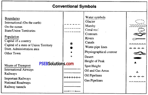
What do you understand by the conventional symbols?
Answer:
It is not possible to show on the map the actual shape of features such as a building, a well or a tree. So symbols are used to represent various features in maps. With their help, it is easier and quicker to read and understand the maps. They also make the map clearer and easier to be read. As there has been a common agreement all over the world regarding the use of these symbols, they are called conventional symbols.
![]()
Question 8.
Make a chart of the conventional symbols.
Answer:
Question 9.
In coloured maps, with which colour we show mountains, uplands, plains, rivers, forest and snow-covered hills.
Answer:
| Physical Features | Colour |
| 1. Mountains | Brown |
| 2. Uplands | Yellow |
| 3. Plains | Green |
| 4. Rivers | Blue |
| 5. Forest | Green |
| 6. Snow covered Hills | White |
Question 10.
What is the use of directions in the maps?
Answer:
In the upper right-hand margin of the maps we see an arrow. The tip of the arrow is marked with the letter ‘N’
It means that the arrow is pointing northwards. The arrow is, therefore, called the North Line.
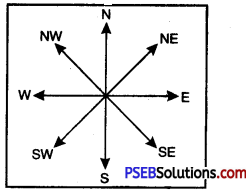
Direction
![]()
Question 11.
How does scale of the map help us to study the maps?
Answer:
Scale of the map is a measuring line with the help of which correct distance between various points on a map can be measured. In a scale, there is always a proportion between the dimensions of the map and the actual areas they represent on the earth. It can be a millimetre, a centimetre or an inch to represent a kilometre, a hundred kilometre or even still larger distances.
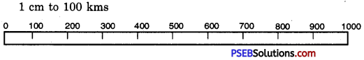
Scale
Question 12.
What is the importance of the key in a map?
Answer:
The key in a map tells us what each symbol used in the map stands for. In other words, key explains symbols.
PSEB 6th Class Social Science Guide How Maps Help Us Important Questions and Answers
Multiple Choice Questions :
Question 1.
Thick blue line on map is usually used to show :
(A) Electricity power station
(B) Stream
(C) River
(D) Dam.
Answer:
(C) River.
Question 2.
A large scale drawing showing greater details is called :
(A) Plan
(B) Sketch
(C) Map
(D) Compose.
Answer:
(A) Plan.
Question 3.
Element of map that shows relationship between actual distance and length on map is
(A) Grid line
(B) Key line
(C) Legend line
(D) Scale.
Answer:
(D) Scale.
Question 4.
Maps that represent a particular theme are called :
(A) Physical
(B) Thematic
(C) Historical
(D) Wall maps.
Answer:
(B) Thematic.
![]()
Question 5.
Survey maps are also called :
(A) Topographical maps
(B) Physical maps
(C) Thematic maps
(D) Historical maps.
Answer:
(A) Topographical maps.
Fill in the Blanks :
Question 1.
________ is an instrument used to find the directions.
Answer:
Compass
Question 2.
There are ________ cardinal directions.
Answer:
Four
Question 3.
Blue colour is used for showing ________
Answer:
Water bodies
Question 4.
________ is the true model of the earth.
Answer:
Globe
![]()
Question 5.
________ colour is used for showing mountain.
Answer:
Brown.
True/False :
Question 1.
Maps are tools of geography.
Answer:
True
Question 2.
Every feature can be shown in detail on a globe.
Answer:
False
Question 3.
The tip of the arrow is marked with the letter ‘N’
Answer:
True
Question 4.
Topographical maps are the only which show only physical features.
Answer:
False
![]()
Question 5.
Colours are mostly used in maps.
Answer:
True.
Very Short Answer Type Questions
Question 1.
What is Geography?
Answer:
Geography is that branch of science which deals with the earth, its surroundings and the people who live on it.
Question 2.
What is a physical map?
Answer:
A physical map is one which shows different features of land-forms.
Question 3.
For what are historical maps used?
Answer:
Historical maps are used to explain historical events.
Question 4.
What is a political map?
Answer:
A map showing different countries and states of the world with their boundaries is called a political map.
Question 5.
For what purpose are wall maps used?
Answer:
Wall maps are used for demonstration and lecture purpose.
Question 6.
What is a scale?
Answer:
The relation between the distance of two points in the map and the two corresponding points on the land is known as a scale.
![]()
Question 7.
What does the tip of arrow in the right hand margin of map show?
Answer:
The tip of arrow shows northwards.
Question 8.
What are the four cardinal points of a compass?
Answer:
The four cardinal points of a compass are North, South, East and West.
Question 9.
What does the term ‘one centimetre to one kilometre’ indicate in a map?
Answer:
It indicates that one centimetre on the map represents one kilometre on the ground.
Short Answer Type Questions
Question 1.
Why can’t maps be as accurate as globes?
Answer:
Maps can’t be as accurate as globes because the maps are drawn on flat surfaces. They show the earth’s surface or a part of it according to some scale. It is impossible to flatten a round shape completely. As a result, the northern and the southern parts of the earth are stretched out of proportion. But the globes are very accurate because the shapes and sizes of continents and oceans are shown accurately on them.
Question 2.
How are maps helpful in our daily life?
Answer:
Maps provide us great help in our daily life. They help us in locating places and reaching wherever we want. People travel all around the world with the help of maps.
Question 3.
What are Topographical Maps?
Answer:
Topographical maps are the ones which show natural features as well as man-made features like roads, railways, etc. They are prepared by the survey department of each country. They are helpful for town planning, for use by the army and for various study purposes.
![]()
Question 4.
Distinction between a map and a plan.
Answer:
| Map | Plan |
| 1. The map shows a large area on a sheet of paper such as world, continents, countries etc. | 1. It shows a small area on a sheet of paper such as a room, a garden, school building etc. |
| 2. The map is drawn on a small scale such as 1 centimetre = 1 kilometre etc. | 2. The plan is drawn on a large scale such as 1 centimetre = 1 metre. |
| 3. Colours are mostly used in maps. | 3. The plans are mostly simple. |
| 4. Only the important features can be shown in brief on a map. | 4. Even details of small and unimportant areas can be shown on a plan. |
Question 5.
What are the components of maps?
Answer:
(a) Distance
(b) Direction and
(c) Symbol.
Distance: Distance is measured with the help of a scale.
Direction:
- Direction is known by the arrow marked with ‘N’ on the map.
- It is also known as an instrument called a compass.
Symbol: Universally accepted marks or icons to depict information on the maps are known as symbols.
Long Answer Type Question
Question 1.
Describe the various types of maps.
Answer:
Maps are very useful in modern life. Therefore, various types of maps are drawn according to the purpose of the study. Some important types of them are given as under :
- Physical Maps: Maps showing physical features of the earth such as landforms of different elevations, i.e. mountains, plateaus, plains, rivers, oceans, etc. are called physical maps.
- Political Maps: Political maps are the maps that show different countries and states of the world with their boundaries.
- Historical Maps: Historical maps show historical events such as war, the spread of civilization, an important voyage, etc.
- Distributional Maps: Distributional maps are also called commodity maps. They are used to show the distribution of various commodities such as crops, population, minerals, etc.
- Topographical Maps: Topographical maps are used to show natural as well as man-made features such as roads, railways, etc.
- Atlas Maps: Atlas maps are in the form of a book. They are easy to carry and are useful for students. They are small-scale maps.
- Wall Maps: Wall maps are used for the purpose of demonstration and lecture. These are bigger than atlas maps.